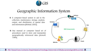
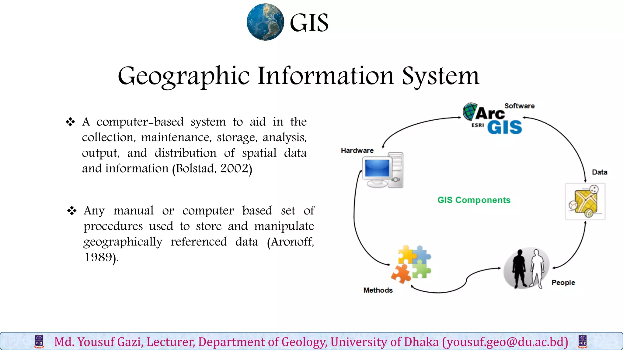
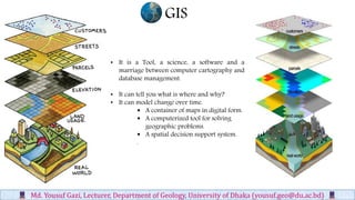
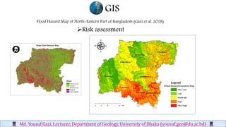
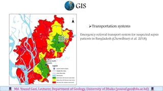
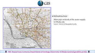
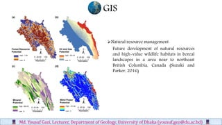
SlideShare a Scribd company logo
Geographic Information System
 A computer-based system to aid in the
collection, maintenance, storage, analysis,
output, and distribution of spatial data
and information (Bolstad, 2002)
GIS
Md. Yousuf Gazi, Lecturer, Department of Geology, University of Dhaka (yousuf.geo@du.ac.bd)
 Any manual or computer based set of
procedures used to store and manipulate
geographically referenced data (Aronoff,
1989).
Md. Yousuf Gazi, Lecturer, Department of Geology, University of Dhaka (yousuf.geo@du.ac.bd)
• It is a Tool, a science, a software and a
marriage between computer cartography and
database management.
• It can tell you what is where and why?
• It can model change over time.
 A container of maps in digital form.
 A computerized tool for solving
geographic problems.
 A spatial decision support system.
.
GIS
GIS
Md. Yousuf Gazi, Lecturer, Department of Geology, University of Dhaka (yousuf.geo@du.ac.bd)
Computer Aided
Cartography
(CAC)
Remote Sensing
(RS)
Computer Aided Design/
Drafting
(CAD)
Database
Management
Systems
(DBMS)
GIS
Integrated Technologies
GIS
Md. Yousuf Gazi, Lecturer, Department of Geology, University of Dhaka (yousuf.geo@du.ac.bd)
Risk assessment
• Natural disasters, disease infection, etc.
Transportation systems
• Highways and interstates, subway and bus routes
Infrastructure
• Power grids, sewage, water and gas lines
Natural resource management
 Resources inventory (what is available at
where?)
 Network Analysis (How to get to a place
in the shortest amount of time?)
 Location Analysis (Where is the best
place to locate a shopping mall?)
 Terrain Analysis (What is the danger
zone for a natural disaster? Visibility
analysis)
 Spatio-Temporal Analysis (Land use:
what has changed over the last twenty
years, and why?)
GIS
Md. Yousuf Gazi, Lecturer, Department of Geology, University of Dhaka (yousuf.geo@du.ac.bd)
Risk assessment
Flood Hazard Map of North-Eastern Part of Bangladesh (Gazi et al. 2018)
GIS
Md. Yousuf Gazi, Lecturer, Department of Geology, University of Dhaka (yousuf.geo@du.ac.bd)
Transportation systems
Emergency referral transport system for suspected sepsis
patients in Bangladesh (Chowdhury et al. 2018)
GIS
Md. Yousuf Gazi, Lecturer, Department of Geology, University of Dhaka (yousuf.geo@du.ac.bd)
Main pipe network of the water supply
in Dhaka city
Source: Survey of Bangladesh (sob)
Infrastructure
GIS
Md. Yousuf Gazi, Lecturer, Department of Geology, University of Dhaka (yousuf.geo@du.ac.bd)
Future development of natural resources
and high-value wildlife habitats in boreal
landscapes in a area near to northeast
British Columbia, Canada (Suzuki and
Parker, 2016)
Natural resource management
GIS
Md. Yousuf Gazi, Lecturer, Department of Geology, University of Dhaka (yousuf.geo@du.ac.bd)

More Related Content

What's hot

GIS
GISGIS
Chap1 introduction to geographic information system (gis)
Chap1 introduction to geographic information system (gis)Chap1 introduction to geographic information system (gis)
Chap1 introduction to geographic information system (gis)
Mweemba Hachita
 
Introduction and Application of GIS
Introduction and Application of GISIntroduction and Application of GIS
Introduction and Application of GIS
Satish Taji
 
Introduction to gis and its application
Introduction to gis and its application Introduction to gis and its application
Introduction to gis and its application
gandhinagar
 
Introduction to GIS systems
Introduction to GIS systemsIntroduction to GIS systems
Introduction to GIS systemsVivek Srivastava
 
GEOGRAPHICAL INFORMATION SYSTEM (GIS)
GEOGRAPHICAL INFORMATION SYSTEM (GIS)GEOGRAPHICAL INFORMATION SYSTEM (GIS)
GEOGRAPHICAL INFORMATION SYSTEM (GIS)
Siva Mbbs
 
Application of GIS (Geographical information system)
Application of GIS (Geographical information system)Application of GIS (Geographical information system)
Application of GIS (Geographical information system)
Fayaz Ahamed A P
 
Gis powerpoint
Gis powerpointGis powerpoint
Gis powerpoint
kaushdave
 
Remote Sensing Platforms and Its types
Remote Sensing Platforms and Its typesRemote Sensing Platforms and Its types
Remote Sensing Platforms and Its types
Senthamizhan M
 
Quantitative revolution and phenomenology
Quantitative revolution and phenomenologyQuantitative revolution and phenomenology
Quantitative revolution and phenomenology
AsrafulMandal
 
Classification of knowledge and place of geography
Classification of knowledge and place of geography Classification of knowledge and place of geography
Classification of knowledge and place of geography
Banaras Hindu University, Varanasi
 
Introduction to GIS
Introduction to GISIntroduction to GIS
Introduction to GIS
KU Leuven
 
Introduction to GIS
Introduction to GISIntroduction to GIS
Introduction to GIS
Hans van der Kwast
 
Application of gis & rs in urban planning
Application of gis & rs in urban planning Application of gis & rs in urban planning
Application of gis & rs in urban planning
sathish1446
 
Introduction to gis and arc gis
Introduction to gis and arc gis Introduction to gis and arc gis
Introduction to gis and arc gis
Saad Raja
 
GIS - Topology
GIS - Topology GIS - Topology
GIS - Topology
Malla Reddy University
 
Geo referencing by Mashhood Arif
Geo referencing by Mashhood ArifGeo referencing by Mashhood Arif
Geo referencing by Mashhood Arif
KU Leuven
 
History of gis
History of gisHistory of gis
History of gis
Ehtisham Wajid
 
Remote Sensing and GIS in Land Use / Land Cover Mapping
Remote Sensing and GIS in Land Use / Land Cover MappingRemote Sensing and GIS in Land Use / Land Cover Mapping
Remote Sensing and GIS in Land Use / Land Cover Mapping
VenkatKamal1
 

What's hot (20)

GIS
GISGIS
GIS
 
Chap1 introduction to geographic information system (gis)
Chap1 introduction to geographic information system (gis)Chap1 introduction to geographic information system (gis)
Chap1 introduction to geographic information system (gis)
 
Introduction and Application of GIS
Introduction and Application of GISIntroduction and Application of GIS
Introduction and Application of GIS
 
Introduction to gis and its application
Introduction to gis and its application Introduction to gis and its application
Introduction to gis and its application
 
Introduction to GIS systems
Introduction to GIS systemsIntroduction to GIS systems
Introduction to GIS systems
 
GEOGRAPHICAL INFORMATION SYSTEM (GIS)
GEOGRAPHICAL INFORMATION SYSTEM (GIS)GEOGRAPHICAL INFORMATION SYSTEM (GIS)
GEOGRAPHICAL INFORMATION SYSTEM (GIS)
 
Application of GIS (Geographical information system)
Application of GIS (Geographical information system)Application of GIS (Geographical information system)
Application of GIS (Geographical information system)
 
Gis powerpoint
Gis powerpointGis powerpoint
Gis powerpoint
 
Remote Sensing Platforms and Its types
Remote Sensing Platforms and Its typesRemote Sensing Platforms and Its types
Remote Sensing Platforms and Its types
 
Quantitative revolution and phenomenology
Quantitative revolution and phenomenologyQuantitative revolution and phenomenology
Quantitative revolution and phenomenology
 
Classification of knowledge and place of geography
Classification of knowledge and place of geography Classification of knowledge and place of geography
Classification of knowledge and place of geography
 
Vectors and Rasters
Vectors and RastersVectors and Rasters
Vectors and Rasters
 
Introduction to GIS
Introduction to GISIntroduction to GIS
Introduction to GIS
 
Introduction to GIS
Introduction to GISIntroduction to GIS
Introduction to GIS
 
Application of gis & rs in urban planning
Application of gis & rs in urban planning Application of gis & rs in urban planning
Application of gis & rs in urban planning
 
Introduction to gis and arc gis
Introduction to gis and arc gis Introduction to gis and arc gis
Introduction to gis and arc gis
 
GIS - Topology
GIS - Topology GIS - Topology
GIS - Topology
 
Geo referencing by Mashhood Arif
Geo referencing by Mashhood ArifGeo referencing by Mashhood Arif
Geo referencing by Mashhood Arif
 
History of gis
History of gisHistory of gis
History of gis
 
Remote Sensing and GIS in Land Use / Land Cover Mapping
Remote Sensing and GIS in Land Use / Land Cover MappingRemote Sensing and GIS in Land Use / Land Cover Mapping
Remote Sensing and GIS in Land Use / Land Cover Mapping
 

Similar to Geographic information system

Gis data source (geo spatial data) md. yousuf gazi
Gis data source (geo spatial data) md. yousuf gaziGis data source (geo spatial data) md. yousuf gazi
Gis data source (geo spatial data) md. yousuf gazi
Md. Yousuf Gazi
 
Introductory GIS
Introductory GISIntroductory GIS
Introductory GIS
Md. Yousuf Gazi
 
Gi science discipline_foloo
Gi science discipline_folooGi science discipline_foloo
Gi science discipline_foloooloofrank
 
Gis Geographical Information System Fundamentals
Gis Geographical Information System FundamentalsGis Geographical Information System Fundamentals
Gis Geographical Information System Fundamentals
Uroosa Samman
 
Importance and application of gis for environmental sustainability
Importance and application of gis for environmental sustainabilityImportance and application of gis for environmental sustainability
Importance and application of gis for environmental sustainability
Abdulla - Al Kafy
 
GIS KD.pdf
GIS KD.pdfGIS KD.pdf
GIS KD.pdf
AkashBhagat34
 
Application of gis Md. Yousuf Gazi
Application of gis Md. Yousuf GaziApplication of gis Md. Yousuf Gazi
Application of gis Md. Yousuf Gazi
Md. Yousuf Gazi
 
FULLYFINAL GIS CHOUBEYJI.pptx
FULLYFINAL GIS CHOUBEYJI.pptxFULLYFINAL GIS CHOUBEYJI.pptx
FULLYFINAL GIS CHOUBEYJI.pptx
AkashBhagat34
 
Image information extraction techniques gazi
Image information extraction techniques gaziImage information extraction techniques gazi
Image information extraction techniques gazi
Md. Yousuf Gazi
 
Geospatial Outreach and Support at Stanford University - Julie Sweetkind-Sing...
Geospatial Outreach and Support at Stanford University - Julie Sweetkind-Sing...Geospatial Outreach and Support at Stanford University - Julie Sweetkind-Sing...
Geospatial Outreach and Support at Stanford University - Julie Sweetkind-Sing...
JISC GECO
 
ICT in Geography
ICT in GeographyICT in Geography
ICT in Geography
Arup Dasgupta
 
Introduction to geomatics
Introduction to geomaticsIntroduction to geomatics
Introduction to geomatics
Islamic University, Kushtia, Bangladesh
 
Lidar remote sensing md. yousuf gazi
Lidar remote sensing md. yousuf gaziLidar remote sensing md. yousuf gazi
Lidar remote sensing md. yousuf gazi
Md. Yousuf Gazi
 
GIScience_all.pdf
GIScience_all.pdfGIScience_all.pdf
GIScience_all.pdf
ssuser38add91
 
Effective Management of Geographical Information in Map/GIS Libraries
Effective Management of Geographical Information  in Map/GIS LibrariesEffective Management of Geographical Information  in Map/GIS Libraries
Effective Management of Geographical Information in Map/GIS Libraries
Ifigenia Vardakosta
 
Intern report final
Intern report finalIntern report final
Intern report finalFazlul wahid
 
Gis basic-2
Gis basic-2Gis basic-2
Gis basic-2
RJRANJEET1
 
2-3-intro11.ppt
2-3-intro11.ppt2-3-intro11.ppt
2-3-intro11.ppt
Temur10
 
ICTs in Geography
ICTs in GeographyICTs in Geography
ICTs in Geography
Namdev Telore
 

Similar to Geographic information system (20)

Gis data source (geo spatial data) md. yousuf gazi
Gis data source (geo spatial data) md. yousuf gaziGis data source (geo spatial data) md. yousuf gazi
Gis data source (geo spatial data) md. yousuf gazi
 
Introductory GIS
Introductory GISIntroductory GIS
Introductory GIS
 
Gi science discipline_foloo
Gi science discipline_folooGi science discipline_foloo
Gi science discipline_foloo
 
Gis Geographical Information System Fundamentals
Gis Geographical Information System FundamentalsGis Geographical Information System Fundamentals
Gis Geographical Information System Fundamentals
 
Importance and application of gis for environmental sustainability
Importance and application of gis for environmental sustainabilityImportance and application of gis for environmental sustainability
Importance and application of gis for environmental sustainability
 
GIS KD.pdf
GIS KD.pdfGIS KD.pdf
GIS KD.pdf
 
Application of gis Md. Yousuf Gazi
Application of gis Md. Yousuf GaziApplication of gis Md. Yousuf Gazi
Application of gis Md. Yousuf Gazi
 
FULLYFINAL GIS CHOUBEYJI.pptx
FULLYFINAL GIS CHOUBEYJI.pptxFULLYFINAL GIS CHOUBEYJI.pptx
FULLYFINAL GIS CHOUBEYJI.pptx
 
Image information extraction techniques gazi
Image information extraction techniques gaziImage information extraction techniques gazi
Image information extraction techniques gazi
 
Geospatial Outreach and Support at Stanford University - Julie Sweetkind-Sing...
Geospatial Outreach and Support at Stanford University - Julie Sweetkind-Sing...Geospatial Outreach and Support at Stanford University - Julie Sweetkind-Sing...
Geospatial Outreach and Support at Stanford University - Julie Sweetkind-Sing...
 
ICT in Geography
ICT in GeographyICT in Geography
ICT in Geography
 
Introduction to geomatics
Introduction to geomaticsIntroduction to geomatics
Introduction to geomatics
 
Lidar remote sensing md. yousuf gazi
Lidar remote sensing md. yousuf gaziLidar remote sensing md. yousuf gazi
Lidar remote sensing md. yousuf gazi
 
GIScience_all.pdf
GIScience_all.pdfGIScience_all.pdf
GIScience_all.pdf
 
Effective Management of Geographical Information in Map/GIS Libraries
Effective Management of Geographical Information  in Map/GIS LibrariesEffective Management of Geographical Information  in Map/GIS Libraries
Effective Management of Geographical Information in Map/GIS Libraries
 
Intern report final
Intern report finalIntern report final
Intern report final
 
Gis basic-2
Gis basic-2Gis basic-2
Gis basic-2
 
2-3-intro11.ppt
2-3-intro11.ppt2-3-intro11.ppt
2-3-intro11.ppt
 
ICTs in Geography
ICTs in GeographyICTs in Geography
ICTs in Geography
 
JGE_2016
JGE_2016JGE_2016
JGE_2016
 

More from Md. Yousuf Gazi

Coastal biodiversity md. yousuf gazi
Coastal biodiversity md. yousuf gaziCoastal biodiversity md. yousuf gazi
Coastal biodiversity md. yousuf gazi
Md. Yousuf Gazi
 
Coastal engineering md. yousuf gazi
Coastal engineering md. yousuf gaziCoastal engineering md. yousuf gazi
Coastal engineering md. yousuf gazi
Md. Yousuf Gazi
 
Coastal economic resource md. yousuf gazi
Coastal economic resource md. yousuf gaziCoastal economic resource md. yousuf gazi
Coastal economic resource md. yousuf gazi
Md. Yousuf Gazi
 
Coastal vulnerability md. yousuf gazi
Coastal vulnerability md. yousuf gaziCoastal vulnerability md. yousuf gazi
Coastal vulnerability md. yousuf gazi
Md. Yousuf Gazi
 
Coastal physical processes md. yousuf gazi
Coastal physical processes md. yousuf gaziCoastal physical processes md. yousuf gazi
Coastal physical processes md. yousuf gazi
Md. Yousuf Gazi
 
Coastal env. impact assessment md. yousuf gazi
Coastal env. impact assessment md. yousuf gaziCoastal env. impact assessment md. yousuf gazi
Coastal env. impact assessment md. yousuf gazi
Md. Yousuf Gazi
 
Coastal hazards md. yousuf gazi
Coastal hazards md. yousuf gaziCoastal hazards md. yousuf gazi
Coastal hazards md. yousuf gazi
Md. Yousuf Gazi
 
Integrated coastal zone management md. yousuf gazi
Integrated coastal zone management md. yousuf gaziIntegrated coastal zone management md. yousuf gazi
Integrated coastal zone management md. yousuf gazi
Md. Yousuf Gazi
 
Thermal infrared remote sensing md. yousuf gazi
Thermal infrared remote sensing md. yousuf gaziThermal infrared remote sensing md. yousuf gazi
Thermal infrared remote sensing md. yousuf gazi
Md. Yousuf Gazi
 
Map projection md. yousuf gazi
Map projection md. yousuf gaziMap projection md. yousuf gazi
Map projection md. yousuf gazi
Md. Yousuf Gazi
 
Introduction to remote sensing md. yousuf gazi
Introduction to remote sensing md. yousuf gaziIntroduction to remote sensing md. yousuf gazi
Introduction to remote sensing md. yousuf gazi
Md. Yousuf Gazi
 
Image classification md. yousuf gazi
Image classification md. yousuf gaziImage classification md. yousuf gazi
Image classification md. yousuf gazi
Md. Yousuf Gazi
 
Geodesy md. yousuf gazi
Geodesy md. yousuf gaziGeodesy md. yousuf gazi
Geodesy md. yousuf gazi
Md. Yousuf Gazi
 
Seismology & earthquake md. yousuf gazi
Seismology & earthquake md. yousuf gaziSeismology & earthquake md. yousuf gazi
Seismology & earthquake md. yousuf gazi
Md. Yousuf Gazi
 
Plate tectonics md. yousuf gazi
Plate tectonics md. yousuf gaziPlate tectonics md. yousuf gazi
Plate tectonics md. yousuf gazi
Md. Yousuf Gazi
 
Mountain building & volcanism md. yousuf gazi
Mountain building & volcanism md. yousuf gaziMountain building & volcanism md. yousuf gazi
Mountain building & volcanism md. yousuf gazi
Md. Yousuf Gazi
 
Introduction to geology md. yousuf gazi
Introduction to geology md. yousuf gaziIntroduction to geology md. yousuf gazi
Introduction to geology md. yousuf gazi
Md. Yousuf Gazi
 
Geological time scale md. yousuf gazi
Geological time scale md. yousuf gaziGeological time scale md. yousuf gazi
Geological time scale md. yousuf gazi
Md. Yousuf Gazi
 
Earth surface processes md. yousuf gazi
Earth surface processes md. yousuf gaziEarth surface processes md. yousuf gazi
Earth surface processes md. yousuf gazi
Md. Yousuf Gazi
 
Earth internal structure md. yousuf gazi
Earth internal structure md. yousuf gaziEarth internal structure md. yousuf gazi
Earth internal structure md. yousuf gazi
Md. Yousuf Gazi
 

More from Md. Yousuf Gazi (20)

Coastal biodiversity md. yousuf gazi
Coastal biodiversity md. yousuf gaziCoastal biodiversity md. yousuf gazi
Coastal biodiversity md. yousuf gazi
 
Coastal engineering md. yousuf gazi
Coastal engineering md. yousuf gaziCoastal engineering md. yousuf gazi
Coastal engineering md. yousuf gazi
 
Coastal economic resource md. yousuf gazi
Coastal economic resource md. yousuf gaziCoastal economic resource md. yousuf gazi
Coastal economic resource md. yousuf gazi
 
Coastal vulnerability md. yousuf gazi
Coastal vulnerability md. yousuf gaziCoastal vulnerability md. yousuf gazi
Coastal vulnerability md. yousuf gazi
 
Coastal physical processes md. yousuf gazi
Coastal physical processes md. yousuf gaziCoastal physical processes md. yousuf gazi
Coastal physical processes md. yousuf gazi
 
Coastal env. impact assessment md. yousuf gazi
Coastal env. impact assessment md. yousuf gaziCoastal env. impact assessment md. yousuf gazi
Coastal env. impact assessment md. yousuf gazi
 
Coastal hazards md. yousuf gazi
Coastal hazards md. yousuf gaziCoastal hazards md. yousuf gazi
Coastal hazards md. yousuf gazi
 
Integrated coastal zone management md. yousuf gazi
Integrated coastal zone management md. yousuf gaziIntegrated coastal zone management md. yousuf gazi
Integrated coastal zone management md. yousuf gazi
 
Thermal infrared remote sensing md. yousuf gazi
Thermal infrared remote sensing md. yousuf gaziThermal infrared remote sensing md. yousuf gazi
Thermal infrared remote sensing md. yousuf gazi
 
Map projection md. yousuf gazi
Map projection md. yousuf gaziMap projection md. yousuf gazi
Map projection md. yousuf gazi
 
Introduction to remote sensing md. yousuf gazi
Introduction to remote sensing md. yousuf gaziIntroduction to remote sensing md. yousuf gazi
Introduction to remote sensing md. yousuf gazi
 
Image classification md. yousuf gazi
Image classification md. yousuf gaziImage classification md. yousuf gazi
Image classification md. yousuf gazi
 
Geodesy md. yousuf gazi
Geodesy md. yousuf gaziGeodesy md. yousuf gazi
Geodesy md. yousuf gazi
 
Seismology & earthquake md. yousuf gazi
Seismology & earthquake md. yousuf gaziSeismology & earthquake md. yousuf gazi
Seismology & earthquake md. yousuf gazi
 
Plate tectonics md. yousuf gazi
Plate tectonics md. yousuf gaziPlate tectonics md. yousuf gazi
Plate tectonics md. yousuf gazi
 
Mountain building & volcanism md. yousuf gazi
Mountain building & volcanism md. yousuf gaziMountain building & volcanism md. yousuf gazi
Mountain building & volcanism md. yousuf gazi
 
Introduction to geology md. yousuf gazi
Introduction to geology md. yousuf gaziIntroduction to geology md. yousuf gazi
Introduction to geology md. yousuf gazi
 
Geological time scale md. yousuf gazi
Geological time scale md. yousuf gaziGeological time scale md. yousuf gazi
Geological time scale md. yousuf gazi
 
Earth surface processes md. yousuf gazi
Earth surface processes md. yousuf gaziEarth surface processes md. yousuf gazi
Earth surface processes md. yousuf gazi
 
Earth internal structure md. yousuf gazi
Earth internal structure md. yousuf gaziEarth internal structure md. yousuf gazi
Earth internal structure md. yousuf gazi
 

Recently uploaded

Digital Tools and AI for Teaching Learning and Research
Digital Tools and AI for Teaching Learning and ResearchDigital Tools and AI for Teaching Learning and Research
Digital Tools and AI for Teaching Learning and Research
Vikramjit Singh
 
1.4 modern child centered education - mahatma gandhi-2.pptx
1.4 modern child centered education - mahatma gandhi-2.pptx1.4 modern child centered education - mahatma gandhi-2.pptx
1.4 modern child centered education - mahatma gandhi-2.pptx
JosvitaDsouza2
 
aaaaaaaaaaaaaaaaaaaaaaaaaaaaaaaaaaaaaaaaa
aaaaaaaaaaaaaaaaaaaaaaaaaaaaaaaaaaaaaaaaaaaaaaaaaaaaaaaaaaaaaaaaaaaaaaaaaaaaaaaaaa
aaaaaaaaaaaaaaaaaaaaaaaaaaaaaaaaaaaaaaaaa
siemaillard
 
special B.ed 2nd year old paper_20240531.pdf
special B.ed 2nd year old paper_20240531.pdfspecial B.ed 2nd year old paper_20240531.pdf
special B.ed 2nd year old paper_20240531.pdf
Special education needs
 
Sha'Carri Richardson Presentation 202345
Sha'Carri Richardson Presentation 202345Sha'Carri Richardson Presentation 202345
Sha'Carri Richardson Presentation 202345
beazzy04
 
CACJapan - GROUP Presentation 1- Wk 4.pdf
CACJapan - GROUP Presentation 1- Wk 4.pdfCACJapan - GROUP Presentation 1- Wk 4.pdf
CACJapan - GROUP Presentation 1- Wk 4.pdf
camakaiclarkmusic
 
The geography of Taylor Swift - some ideas
The geography of Taylor Swift - some ideasThe geography of Taylor Swift - some ideas
The geography of Taylor Swift - some ideas
GeoBlogs
 
Mule 4.6 & Java 17 Upgrade | MuleSoft Mysore Meetup #46
Mule 4.6 & Java 17 Upgrade | MuleSoft Mysore Meetup #46Mule 4.6 & Java 17 Upgrade | MuleSoft Mysore Meetup #46
Mule 4.6 & Java 17 Upgrade | MuleSoft Mysore Meetup #46
MysoreMuleSoftMeetup
 
The French Revolution Class 9 Study Material pdf free download
The French Revolution Class 9 Study Material pdf free downloadThe French Revolution Class 9 Study Material pdf free download
The French Revolution Class 9 Study Material pdf free download
Vivekanand Anglo Vedic Academy
 
A Strategic Approach: GenAI in Education
A Strategic Approach: GenAI in EducationA Strategic Approach: GenAI in Education
A Strategic Approach: GenAI in Education
Peter Windle
 
Palestine last event orientationfvgnh .pptx
Palestine last event orientationfvgnh .pptxPalestine last event orientationfvgnh .pptx
Palestine last event orientationfvgnh .pptx
RaedMohamed3
 
678020731-Sumas-y-Restas-Para-Colorear.pdf
678020731-Sumas-y-Restas-Para-Colorear.pdf678020731-Sumas-y-Restas-Para-Colorear.pdf
678020731-Sumas-y-Restas-Para-Colorear.pdf
CarlosHernanMontoyab2
 
The Accursed House by Émile Gaboriau.pptx
The Accursed House by Émile Gaboriau.pptxThe Accursed House by Émile Gaboriau.pptx
The Accursed House by Émile Gaboriau.pptx
DhatriParmar
 
Model Attribute Check Company Auto Property
Model Attribute  Check Company Auto PropertyModel Attribute  Check Company Auto Property
Model Attribute Check Company Auto Property
Celine George
 
Supporting (UKRI) OA monographs at Salford.pptx
Supporting (UKRI) OA monographs at Salford.pptxSupporting (UKRI) OA monographs at Salford.pptx
Supporting (UKRI) OA monographs at Salford.pptx
Jisc
 
Polish students' mobility in the Czech Republic
Polish students' mobility in the Czech RepublicPolish students' mobility in the Czech Republic
Polish students' mobility in the Czech Republic
Anna Sz.
 
Adversarial Attention Modeling for Multi-dimensional Emotion Regression.pdf
Adversarial Attention Modeling for Multi-dimensional Emotion Regression.pdfAdversarial Attention Modeling for Multi-dimensional Emotion Regression.pdf
Adversarial Attention Modeling for Multi-dimensional Emotion Regression.pdf
Po-Chuan Chen
 
The Roman Empire A Historical Colossus.pdf
The Roman Empire A Historical Colossus.pdfThe Roman Empire A Historical Colossus.pdf
The Roman Empire A Historical Colossus.pdf
kaushalkr1407
 
TESDA TM1 REVIEWER FOR NATIONAL ASSESSMENT WRITTEN AND ORAL QUESTIONS WITH A...
TESDA TM1 REVIEWER  FOR NATIONAL ASSESSMENT WRITTEN AND ORAL QUESTIONS WITH A...TESDA TM1 REVIEWER  FOR NATIONAL ASSESSMENT WRITTEN AND ORAL QUESTIONS WITH A...
TESDA TM1 REVIEWER FOR NATIONAL ASSESSMENT WRITTEN AND ORAL QUESTIONS WITH A...
EugeneSaldivar
 
Chapter 3 - Islamic Banking Products and Services.pptx
Chapter 3 - Islamic Banking Products and Services.pptxChapter 3 - Islamic Banking Products and Services.pptx
Chapter 3 - Islamic Banking Products and Services.pptx
Mohd Adib Abd Muin, Senior Lecturer at Universiti Utara Malaysia
 

Recently uploaded (20)

Digital Tools and AI for Teaching Learning and Research
Digital Tools and AI for Teaching Learning and ResearchDigital Tools and AI for Teaching Learning and Research
Digital Tools and AI for Teaching Learning and Research
 
1.4 modern child centered education - mahatma gandhi-2.pptx
1.4 modern child centered education - mahatma gandhi-2.pptx1.4 modern child centered education - mahatma gandhi-2.pptx
1.4 modern child centered education - mahatma gandhi-2.pptx
 
aaaaaaaaaaaaaaaaaaaaaaaaaaaaaaaaaaaaaaaaa
aaaaaaaaaaaaaaaaaaaaaaaaaaaaaaaaaaaaaaaaaaaaaaaaaaaaaaaaaaaaaaaaaaaaaaaaaaaaaaaaaa
aaaaaaaaaaaaaaaaaaaaaaaaaaaaaaaaaaaaaaaaa
 
special B.ed 2nd year old paper_20240531.pdf
special B.ed 2nd year old paper_20240531.pdfspecial B.ed 2nd year old paper_20240531.pdf
special B.ed 2nd year old paper_20240531.pdf
 
Sha'Carri Richardson Presentation 202345
Sha'Carri Richardson Presentation 202345Sha'Carri Richardson Presentation 202345
Sha'Carri Richardson Presentation 202345
 
CACJapan - GROUP Presentation 1- Wk 4.pdf
CACJapan - GROUP Presentation 1- Wk 4.pdfCACJapan - GROUP Presentation 1- Wk 4.pdf
CACJapan - GROUP Presentation 1- Wk 4.pdf
 
The geography of Taylor Swift - some ideas
The geography of Taylor Swift - some ideasThe geography of Taylor Swift - some ideas
The geography of Taylor Swift - some ideas
 
Mule 4.6 & Java 17 Upgrade | MuleSoft Mysore Meetup #46
Mule 4.6 & Java 17 Upgrade | MuleSoft Mysore Meetup #46Mule 4.6 & Java 17 Upgrade | MuleSoft Mysore Meetup #46
Mule 4.6 & Java 17 Upgrade | MuleSoft Mysore Meetup #46
 
The French Revolution Class 9 Study Material pdf free download
The French Revolution Class 9 Study Material pdf free downloadThe French Revolution Class 9 Study Material pdf free download
The French Revolution Class 9 Study Material pdf free download
 
A Strategic Approach: GenAI in Education
A Strategic Approach: GenAI in EducationA Strategic Approach: GenAI in Education
A Strategic Approach: GenAI in Education
 
Palestine last event orientationfvgnh .pptx
Palestine last event orientationfvgnh .pptxPalestine last event orientationfvgnh .pptx
Palestine last event orientationfvgnh .pptx
 
678020731-Sumas-y-Restas-Para-Colorear.pdf
678020731-Sumas-y-Restas-Para-Colorear.pdf678020731-Sumas-y-Restas-Para-Colorear.pdf
678020731-Sumas-y-Restas-Para-Colorear.pdf
 
The Accursed House by Émile Gaboriau.pptx
The Accursed House by Émile Gaboriau.pptxThe Accursed House by Émile Gaboriau.pptx
The Accursed House by Émile Gaboriau.pptx
 
Model Attribute Check Company Auto Property
Model Attribute  Check Company Auto PropertyModel Attribute  Check Company Auto Property
Model Attribute Check Company Auto Property
 
Supporting (UKRI) OA monographs at Salford.pptx
Supporting (UKRI) OA monographs at Salford.pptxSupporting (UKRI) OA monographs at Salford.pptx
Supporting (UKRI) OA monographs at Salford.pptx
 
Polish students' mobility in the Czech Republic
Polish students' mobility in the Czech RepublicPolish students' mobility in the Czech Republic
Polish students' mobility in the Czech Republic
 
Adversarial Attention Modeling for Multi-dimensional Emotion Regression.pdf
Adversarial Attention Modeling for Multi-dimensional Emotion Regression.pdfAdversarial Attention Modeling for Multi-dimensional Emotion Regression.pdf
Adversarial Attention Modeling for Multi-dimensional Emotion Regression.pdf
 
The Roman Empire A Historical Colossus.pdf
The Roman Empire A Historical Colossus.pdfThe Roman Empire A Historical Colossus.pdf
The Roman Empire A Historical Colossus.pdf
 
TESDA TM1 REVIEWER FOR NATIONAL ASSESSMENT WRITTEN AND ORAL QUESTIONS WITH A...
TESDA TM1 REVIEWER  FOR NATIONAL ASSESSMENT WRITTEN AND ORAL QUESTIONS WITH A...TESDA TM1 REVIEWER  FOR NATIONAL ASSESSMENT WRITTEN AND ORAL QUESTIONS WITH A...
TESDA TM1 REVIEWER FOR NATIONAL ASSESSMENT WRITTEN AND ORAL QUESTIONS WITH A...
 
Chapter 3 - Islamic Banking Products and Services.pptx
Chapter 3 - Islamic Banking Products and Services.pptxChapter 3 - Islamic Banking Products and Services.pptx
Chapter 3 - Islamic Banking Products and Services.pptx
 

Geographic information system

  • 1. Geographic Information System  A computer-based system to aid in the collection, maintenance, storage, analysis, output, and distribution of spatial data and information (Bolstad, 2002) GIS Md. Yousuf Gazi, Lecturer, Department of Geology, University of Dhaka (yousuf.geo@du.ac.bd)  Any manual or computer based set of procedures used to store and manipulate geographically referenced data (Aronoff, 1989).
  • 2. Md. Yousuf Gazi, Lecturer, Department of Geology, University of Dhaka (yousuf.geo@du.ac.bd) • It is a Tool, a science, a software and a marriage between computer cartography and database management. • It can tell you what is where and why? • It can model change over time.  A container of maps in digital form.  A computerized tool for solving geographic problems.  A spatial decision support system. . GIS
  • 3. GIS Md. Yousuf Gazi, Lecturer, Department of Geology, University of Dhaka (yousuf.geo@du.ac.bd) Computer Aided Cartography (CAC) Remote Sensing (RS) Computer Aided Design/ Drafting (CAD) Database Management Systems (DBMS) GIS Integrated Technologies
  • 4. GIS Md. Yousuf Gazi, Lecturer, Department of Geology, University of Dhaka (yousuf.geo@du.ac.bd) Risk assessment • Natural disasters, disease infection, etc. Transportation systems • Highways and interstates, subway and bus routes Infrastructure • Power grids, sewage, water and gas lines Natural resource management  Resources inventory (what is available at where?)  Network Analysis (How to get to a place in the shortest amount of time?)  Location Analysis (Where is the best place to locate a shopping mall?)  Terrain Analysis (What is the danger zone for a natural disaster? Visibility analysis)  Spatio-Temporal Analysis (Land use: what has changed over the last twenty years, and why?)
  • 5. GIS Md. Yousuf Gazi, Lecturer, Department of Geology, University of Dhaka (yousuf.geo@du.ac.bd) Risk assessment Flood Hazard Map of North-Eastern Part of Bangladesh (Gazi et al. 2018)
  • 6. GIS Md. Yousuf Gazi, Lecturer, Department of Geology, University of Dhaka (yousuf.geo@du.ac.bd) Transportation systems Emergency referral transport system for suspected sepsis patients in Bangladesh (Chowdhury et al. 2018)
  • 7. GIS Md. Yousuf Gazi, Lecturer, Department of Geology, University of Dhaka (yousuf.geo@du.ac.bd) Main pipe network of the water supply in Dhaka city Source: Survey of Bangladesh (sob) Infrastructure
  • 8. GIS Md. Yousuf Gazi, Lecturer, Department of Geology, University of Dhaka (yousuf.geo@du.ac.bd) Future development of natural resources and high-value wildlife habitats in boreal landscapes in a area near to northeast British Columbia, Canada (Suzuki and Parker, 2016) Natural resource management
  • 9. GIS Md. Yousuf Gazi, Lecturer, Department of Geology, University of Dhaka (yousuf.geo@du.ac.bd)