SlideShare a Scribd company logo
1 of 16
Download to read offline
• Urban Planning, Management & Policy
• Zoning, subdivision planning
• Land acquisition
• Economic development
• Code enforcement
• Housing renovation programs
• Emergency response
• Crime analysis
• Tax assessment
• Environmental Sciences
• Monitoring environmental risk
• Modeling storm water runoff
• Management of watersheds, floodplains,
wetlands, forests, aquifers
• Environmental Impact Analysis
• Hazardous or toxic facility siting
• Groundwater modeling and contamination
tracking
• Political Science
• Redistricting
• Analysis of election results
• Predictive modeling
Civil Engineering/Utility
• Locating underground facilities
• Designing alignment for freeways,
transit
• Coordination of infrastructure
maintenance
Business
• Demographic Analysis
• Market Penetration/ Share Analysis
• Site Selection
Education Administration
• Attendance Area Maintenance
• Enrollment Projections
• School Bus Routing
Real Estate
• Neighborhood land prices
• Traffic Impact Analysis
• Determination of Highest and Best
Use
Health Care
• Epidemiology
• Needs Analysis
• Service Inventory
ApplicationsofGIS
GIS
Md. Yousuf Gazi, Lecturer, Department of Geology, University of Dhaka (yousuf.geo@du.ac.bd)
• Zoning, subdivision planning • Land acquisition
GIS
Md. Yousuf Gazi, Lecturer, Department of Geology, University of Dhaka (yousuf.geo@du.ac.bd)
• Economic development
• Housing renovation programsGIS
Md. Yousuf Gazi, Lecturer, Department of Geology, University of Dhaka (yousuf.geo@du.ac.bd)
• Code enforcement
• Emergency response
GIS
Md. Yousuf Gazi, Lecturer, Department of Geology, University of Dhaka (yousuf.geo@du.ac.bd)
• Crime analysis
• Tax assessment
GIS
Md. Yousuf Gazi, Lecturer, Department of Geology, University of Dhaka (yousuf.geo@du.ac.bd)
• Monitoring environmental risk
• Modeling storm water runoff
GIS
Md. Yousuf Gazi, Lecturer, Department of Geology, University of Dhaka (yousuf.geo@du.ac.bd)
• Management of watersheds, floodplains,
wetlands, forests, aquifers
• Environmental Impact Analysis
GIS
Md. Yousuf Gazi, Lecturer, Department of Geology, University of Dhaka (yousuf.geo@du.ac.bd)
• Hazardous or toxic facility siting • Groundwater modeling and contamination
tracking
GIS
Md. Yousuf Gazi, Lecturer, Department of Geology, University of Dhaka (yousuf.geo@du.ac.bd)
• Analysis of election results
• Redistricting
GIS
Md. Yousuf Gazi, Lecturer, Department of Geology, University of Dhaka (yousuf.geo@du.ac.bd)
• Predictive modeling
• Locating underground facilitiesGIS
Md. Yousuf Gazi, Lecturer, Department of Geology, University of Dhaka (yousuf.geo@du.ac.bd)
• Designing alignment for freeways, transit
• Coordination of infrastructure maintenance
GIS
Md. Yousuf Gazi, Lecturer, Department of Geology, University of Dhaka (yousuf.geo@du.ac.bd)
• Demographic Analysis
• Market Penetration/ Share Analysis
GIS
Md. Yousuf Gazi, Lecturer, Department of Geology, University of Dhaka (yousuf.geo@du.ac.bd)
• Site Selection
• Attendance Area MaintenanceGIS
Md. Yousuf Gazi, Lecturer, Department of Geology, University of Dhaka (yousuf.geo@du.ac.bd)
• School Bus Routing
• Neighborhood land prices
GIS
Md. Yousuf Gazi, Lecturer, Department of Geology, University of Dhaka (yousuf.geo@du.ac.bd)
• Traffic Impact Analysis • Epidemiology
GIS
Md. Yousuf Gazi, Lecturer, Department of Geology, University of Dhaka (yousuf.geo@du.ac.bd)
GIS
Md. Yousuf Gazi, Lecturer, Department of Geology, University of Dhaka (yousuf.geo@du.ac.bd)

More Related Content

What's hot

Mountain building & volcanism md. yousuf gazi
Mountain building & volcanism md. yousuf gaziMountain building & volcanism md. yousuf gazi
Mountain building & volcanism md. yousuf gaziMd. Yousuf Gazi
 
Class 11 Cbse Geography Syllabus 2013-14
Class 11 Cbse Geography Syllabus 2013-14Class 11 Cbse Geography Syllabus 2013-14
Class 11 Cbse Geography Syllabus 2013-14Sunaina Rawat
 
Structural Trends from Airborne Gravity Data of Delta State, Nigeria
Structural Trends from Airborne Gravity Data of Delta State, NigeriaStructural Trends from Airborne Gravity Data of Delta State, Nigeria
Structural Trends from Airborne Gravity Data of Delta State, NigeriaAssociate Professor in VSB Coimbatore
 
Field Education 2009 Stewart
Field Education 2009 StewartField Education 2009 Stewart
Field Education 2009 StewartRobert Stewart
 
LAND USE /LAND COVER CLASSIFICATION AND CHANGE DETECTION USING GEOGRAPHICAL I...
LAND USE /LAND COVER CLASSIFICATION AND CHANGE DETECTION USING GEOGRAPHICAL I...LAND USE /LAND COVER CLASSIFICATION AND CHANGE DETECTION USING GEOGRAPHICAL I...
LAND USE /LAND COVER CLASSIFICATION AND CHANGE DETECTION USING GEOGRAPHICAL I...IAEME Publication
 
Geological fieldwork report
Geological fieldwork reportGeological fieldwork report
Geological fieldwork reportBhadra Thakuri
 
Land Use / Land Cover Classification of kanniykumari Coast, Tamilnadu, India....
Land Use / Land Cover Classification of kanniykumari Coast, Tamilnadu, India....Land Use / Land Cover Classification of kanniykumari Coast, Tamilnadu, India....
Land Use / Land Cover Classification of kanniykumari Coast, Tamilnadu, India....IJERA Editor
 
3rd Lesson ( Built Environment in Responding to Natural & Human Environments ...
3rd Lesson ( Built Environment in Responding to Natural & Human Environments ...3rd Lesson ( Built Environment in Responding to Natural & Human Environments ...
3rd Lesson ( Built Environment in Responding to Natural & Human Environments ...Farouk Daghistani
 
Coastal physical processes md. yousuf gazi
Coastal physical processes md. yousuf gaziCoastal physical processes md. yousuf gazi
Coastal physical processes md. yousuf gaziMd. Yousuf Gazi
 
Geomorphological Mapping Using Remote Sensing and GIS A Tool for Land Use Pla...
Geomorphological Mapping Using Remote Sensing and GIS A Tool for Land Use Pla...Geomorphological Mapping Using Remote Sensing and GIS A Tool for Land Use Pla...
Geomorphological Mapping Using Remote Sensing and GIS A Tool for Land Use Pla...IOSR Journals
 
Subsurface Mapping
Subsurface MappingSubsurface Mapping
Subsurface MappingMaliha Mehr
 
Remote sensing-derived national land cover land use maps: a comparison for Ma...
Remote sensing-derived national land cover land use maps: a comparison for Ma...Remote sensing-derived national land cover land use maps: a comparison for Ma...
Remote sensing-derived national land cover land use maps: a comparison for Ma...rsmahabir
 
Coastal engineering md. yousuf gazi
Coastal engineering md. yousuf gaziCoastal engineering md. yousuf gazi
Coastal engineering md. yousuf gaziMd. Yousuf Gazi
 
Structural geology
Structural geologyStructural geology
Structural geologyKhchao Tel
 
Evaluation of Groundwater Resource Potential using GIS and Remote Sensing App...
Evaluation of Groundwater Resource Potential using GIS and Remote Sensing App...Evaluation of Groundwater Resource Potential using GIS and Remote Sensing App...
Evaluation of Groundwater Resource Potential using GIS and Remote Sensing App...IJERA Editor
 
DEVELOPMENT OF DIGITAL ELEVATION MODEL FOR STORM -WATER MODELING FOR COASTAL ...
DEVELOPMENT OF DIGITAL ELEVATION MODEL FOR STORM -WATER MODELING FOR COASTAL ...DEVELOPMENT OF DIGITAL ELEVATION MODEL FOR STORM -WATER MODELING FOR COASTAL ...
DEVELOPMENT OF DIGITAL ELEVATION MODEL FOR STORM -WATER MODELING FOR COASTAL ...IAEME Publication
 

What's hot (18)

Mountain building & volcanism md. yousuf gazi
Mountain building & volcanism md. yousuf gaziMountain building & volcanism md. yousuf gazi
Mountain building & volcanism md. yousuf gazi
 
Class 11 Cbse Geography Syllabus 2013-14
Class 11 Cbse Geography Syllabus 2013-14Class 11 Cbse Geography Syllabus 2013-14
Class 11 Cbse Geography Syllabus 2013-14
 
Structural Trends from Airborne Gravity Data of Delta State, Nigeria
Structural Trends from Airborne Gravity Data of Delta State, NigeriaStructural Trends from Airborne Gravity Data of Delta State, Nigeria
Structural Trends from Airborne Gravity Data of Delta State, Nigeria
 
Field Education 2009 Stewart
Field Education 2009 StewartField Education 2009 Stewart
Field Education 2009 Stewart
 
LAND USE /LAND COVER CLASSIFICATION AND CHANGE DETECTION USING GEOGRAPHICAL I...
LAND USE /LAND COVER CLASSIFICATION AND CHANGE DETECTION USING GEOGRAPHICAL I...LAND USE /LAND COVER CLASSIFICATION AND CHANGE DETECTION USING GEOGRAPHICAL I...
LAND USE /LAND COVER CLASSIFICATION AND CHANGE DETECTION USING GEOGRAPHICAL I...
 
Geological fieldwork report
Geological fieldwork reportGeological fieldwork report
Geological fieldwork report
 
Land Use / Land Cover Classification of kanniykumari Coast, Tamilnadu, India....
Land Use / Land Cover Classification of kanniykumari Coast, Tamilnadu, India....Land Use / Land Cover Classification of kanniykumari Coast, Tamilnadu, India....
Land Use / Land Cover Classification of kanniykumari Coast, Tamilnadu, India....
 
3rd Lesson ( Built Environment in Responding to Natural & Human Environments ...
3rd Lesson ( Built Environment in Responding to Natural & Human Environments ...3rd Lesson ( Built Environment in Responding to Natural & Human Environments ...
3rd Lesson ( Built Environment in Responding to Natural & Human Environments ...
 
Geological mapping
Geological mappingGeological mapping
Geological mapping
 
Coastal physical processes md. yousuf gazi
Coastal physical processes md. yousuf gaziCoastal physical processes md. yousuf gazi
Coastal physical processes md. yousuf gazi
 
Geomorphological Mapping Using Remote Sensing and GIS A Tool for Land Use Pla...
Geomorphological Mapping Using Remote Sensing and GIS A Tool for Land Use Pla...Geomorphological Mapping Using Remote Sensing and GIS A Tool for Land Use Pla...
Geomorphological Mapping Using Remote Sensing and GIS A Tool for Land Use Pla...
 
Subsurface Mapping
Subsurface MappingSubsurface Mapping
Subsurface Mapping
 
Remote sensing-derived national land cover land use maps: a comparison for Ma...
Remote sensing-derived national land cover land use maps: a comparison for Ma...Remote sensing-derived national land cover land use maps: a comparison for Ma...
Remote sensing-derived national land cover land use maps: a comparison for Ma...
 
Coastal engineering md. yousuf gazi
Coastal engineering md. yousuf gaziCoastal engineering md. yousuf gazi
Coastal engineering md. yousuf gazi
 
Structural geology
Structural geologyStructural geology
Structural geology
 
Evaluation of Groundwater Resource Potential using GIS and Remote Sensing App...
Evaluation of Groundwater Resource Potential using GIS and Remote Sensing App...Evaluation of Groundwater Resource Potential using GIS and Remote Sensing App...
Evaluation of Groundwater Resource Potential using GIS and Remote Sensing App...
 
20320130406017 2
20320130406017 220320130406017 2
20320130406017 2
 
DEVELOPMENT OF DIGITAL ELEVATION MODEL FOR STORM -WATER MODELING FOR COASTAL ...
DEVELOPMENT OF DIGITAL ELEVATION MODEL FOR STORM -WATER MODELING FOR COASTAL ...DEVELOPMENT OF DIGITAL ELEVATION MODEL FOR STORM -WATER MODELING FOR COASTAL ...
DEVELOPMENT OF DIGITAL ELEVATION MODEL FOR STORM -WATER MODELING FOR COASTAL ...
 

Similar to Application of gis Md. Yousuf Gazi

Use of remote sensing for land cover monitoring servir science applications
Use of remote sensing for land cover monitoring servir science applicationsUse of remote sensing for land cover monitoring servir science applications
Use of remote sensing for land cover monitoring servir science applicationsKabir Uddin
 
Integrated_Coastal_Zone_Management.pptx
Integrated_Coastal_Zone_Management.pptxIntegrated_Coastal_Zone_Management.pptx
Integrated_Coastal_Zone_Management.pptxmkamalnaser
 
Integrated coastal zone management md. yousuf gazi
Integrated coastal zone management md. yousuf gaziIntegrated coastal zone management md. yousuf gazi
Integrated coastal zone management md. yousuf gaziMd. Yousuf Gazi
 
Geographic information system
Geographic information systemGeographic information system
Geographic information systemMd. Yousuf Gazi
 
Bringing the Data Alive - Dr. A. Gonzalez
Bringing the Data Alive - Dr. A. GonzalezBringing the Data Alive - Dr. A. Gonzalez
Bringing the Data Alive - Dr. A. GonzalezCiara McCabe
 
Application of gis and remote sensing in agriculture
Application of gis and remote sensing in agricultureApplication of gis and remote sensing in agriculture
Application of gis and remote sensing in agricultureRehana Qureshi
 
Introduction to Civil Engineering
Introduction to Civil Engineering Introduction to Civil Engineering
Introduction to Civil Engineering Umer Farooq
 
civilintroduction-130920022924-phpapp01.pdf
civilintroduction-130920022924-phpapp01.pdfcivilintroduction-130920022924-phpapp01.pdf
civilintroduction-130920022924-phpapp01.pdfBaDriGaMeR
 
Application of GIS and Remote Sensing in Flood Risk Management
Application of GIS and Remote Sensing in Flood Risk ManagementApplication of GIS and Remote Sensing in Flood Risk Management
Application of GIS and Remote Sensing in Flood Risk ManagementAmitSaha123
 
civil Introduction. Basic introduction regarding civil engineering
civil Introduction. Basic introduction regarding civil engineeringcivil Introduction. Basic introduction regarding civil engineering
civil Introduction. Basic introduction regarding civil engineeringPradeepPandya1
 
Application of Geo-informatics in Environmental Management
Application of Geo-informatics in Environmental ManagementApplication of Geo-informatics in Environmental Management
Application of Geo-informatics in Environmental ManagementMahaMadhu2
 
Modernization.pptx
Modernization.pptxModernization.pptx
Modernization.pptxUpmaSharma22
 
GIS & Conservation
GIS & ConservationGIS & Conservation
GIS & ConservationRabail Urooj
 
7 - AECOM Water Resources Seminar World Bank -16-Sept
7 - AECOM Water Resources Seminar World Bank -16-Sept7 - AECOM Water Resources Seminar World Bank -16-Sept
7 - AECOM Water Resources Seminar World Bank -16-Septindiawrm
 

Similar to Application of gis Md. Yousuf Gazi (20)

Use of remote sensing for land cover monitoring servir science applications
Use of remote sensing for land cover monitoring servir science applicationsUse of remote sensing for land cover monitoring servir science applications
Use of remote sensing for land cover monitoring servir science applications
 
Integrated_Coastal_Zone_Management.pptx
Integrated_Coastal_Zone_Management.pptxIntegrated_Coastal_Zone_Management.pptx
Integrated_Coastal_Zone_Management.pptx
 
Integrated coastal zone management md. yousuf gazi
Integrated coastal zone management md. yousuf gaziIntegrated coastal zone management md. yousuf gazi
Integrated coastal zone management md. yousuf gazi
 
Geographic information system
Geographic information systemGeographic information system
Geographic information system
 
Application of Remote sensing
Application of Remote sensingApplication of Remote sensing
Application of Remote sensing
 
Option one.pptx
Option one.pptxOption one.pptx
Option one.pptx
 
Document 5 (1).pptx
Document 5 (1).pptxDocument 5 (1).pptx
Document 5 (1).pptx
 
Option one (1).pptx
Option one (1).pptxOption one (1).pptx
Option one (1).pptx
 
Document 5.pptx
Document 5.pptxDocument 5.pptx
Document 5.pptx
 
Bringing the Data Alive - Dr. A. Gonzalez
Bringing the Data Alive - Dr. A. GonzalezBringing the Data Alive - Dr. A. Gonzalez
Bringing the Data Alive - Dr. A. Gonzalez
 
Application of gis and remote sensing in agriculture
Application of gis and remote sensing in agricultureApplication of gis and remote sensing in agriculture
Application of gis and remote sensing in agriculture
 
Introduction to Civil Engineering
Introduction to Civil Engineering Introduction to Civil Engineering
Introduction to Civil Engineering
 
civilintroduction-130920022924-phpapp01.pdf
civilintroduction-130920022924-phpapp01.pdfcivilintroduction-130920022924-phpapp01.pdf
civilintroduction-130920022924-phpapp01.pdf
 
Application of GIS and Remote Sensing in Flood Risk Management
Application of GIS and Remote Sensing in Flood Risk ManagementApplication of GIS and Remote Sensing in Flood Risk Management
Application of GIS and Remote Sensing in Flood Risk Management
 
civil Introduction. Basic introduction regarding civil engineering
civil Introduction. Basic introduction regarding civil engineeringcivil Introduction. Basic introduction regarding civil engineering
civil Introduction. Basic introduction regarding civil engineering
 
civilIntroduction.ppt
civilIntroduction.pptcivilIntroduction.ppt
civilIntroduction.ppt
 
Application of Geo-informatics in Environmental Management
Application of Geo-informatics in Environmental ManagementApplication of Geo-informatics in Environmental Management
Application of Geo-informatics in Environmental Management
 
Modernization.pptx
Modernization.pptxModernization.pptx
Modernization.pptx
 
GIS & Conservation
GIS & ConservationGIS & Conservation
GIS & Conservation
 
7 - AECOM Water Resources Seminar World Bank -16-Sept
7 - AECOM Water Resources Seminar World Bank -16-Sept7 - AECOM Water Resources Seminar World Bank -16-Sept
7 - AECOM Water Resources Seminar World Bank -16-Sept
 

More from Md. Yousuf Gazi

Coastal biodiversity md. yousuf gazi
Coastal biodiversity md. yousuf gaziCoastal biodiversity md. yousuf gazi
Coastal biodiversity md. yousuf gaziMd. Yousuf Gazi
 
Coastal economic resource md. yousuf gazi
Coastal economic resource md. yousuf gaziCoastal economic resource md. yousuf gazi
Coastal economic resource md. yousuf gaziMd. Yousuf Gazi
 
Coastal env. impact assessment md. yousuf gazi
Coastal env. impact assessment md. yousuf gaziCoastal env. impact assessment md. yousuf gazi
Coastal env. impact assessment md. yousuf gaziMd. Yousuf Gazi
 
Coastal hazards md. yousuf gazi
Coastal hazards md. yousuf gaziCoastal hazards md. yousuf gazi
Coastal hazards md. yousuf gaziMd. Yousuf Gazi
 
Thermal infrared remote sensing md. yousuf gazi
Thermal infrared remote sensing md. yousuf gaziThermal infrared remote sensing md. yousuf gazi
Thermal infrared remote sensing md. yousuf gaziMd. Yousuf Gazi
 
Map projection md. yousuf gazi
Map projection md. yousuf gaziMap projection md. yousuf gazi
Map projection md. yousuf gaziMd. Yousuf Gazi
 
Seismology & earthquake md. yousuf gazi
Seismology & earthquake md. yousuf gaziSeismology & earthquake md. yousuf gazi
Seismology & earthquake md. yousuf gaziMd. Yousuf Gazi
 
Plate tectonics md. yousuf gazi
Plate tectonics md. yousuf gaziPlate tectonics md. yousuf gazi
Plate tectonics md. yousuf gaziMd. Yousuf Gazi
 
Introduction to geology md. yousuf gazi
Introduction to geology md. yousuf gaziIntroduction to geology md. yousuf gazi
Introduction to geology md. yousuf gaziMd. Yousuf Gazi
 
Geological time scale md. yousuf gazi
Geological time scale md. yousuf gaziGeological time scale md. yousuf gazi
Geological time scale md. yousuf gaziMd. Yousuf Gazi
 
Earth surface processes md. yousuf gazi
Earth surface processes md. yousuf gaziEarth surface processes md. yousuf gazi
Earth surface processes md. yousuf gaziMd. Yousuf Gazi
 
Earth internal structure md. yousuf gazi
Earth internal structure md. yousuf gaziEarth internal structure md. yousuf gazi
Earth internal structure md. yousuf gaziMd. Yousuf Gazi
 
Basic pricipals of geology md. yousuf gazi
Basic pricipals of geology md. yousuf gaziBasic pricipals of geology md. yousuf gazi
Basic pricipals of geology md. yousuf gaziMd. Yousuf Gazi
 
GEOLOGICAL AND GEOPHYSICAL OBSERVATIONS TO DETERMINE THE GAS SEEPAGE SOURCE O...
GEOLOGICAL AND GEOPHYSICAL OBSERVATIONS TO DETERMINE THE GAS SEEPAGE SOURCE O...GEOLOGICAL AND GEOPHYSICAL OBSERVATIONS TO DETERMINE THE GAS SEEPAGE SOURCE O...
GEOLOGICAL AND GEOPHYSICAL OBSERVATIONS TO DETERMINE THE GAS SEEPAGE SOURCE O...Md. Yousuf Gazi
 
Structure of geographic data
Structure of geographic dataStructure of geographic data
Structure of geographic dataMd. Yousuf Gazi
 
SILT CONTENT APPROXIMATION OF NEOGENE SURMA GROUP MUDROCKS, SITAKUND ANTICLIN...
SILT CONTENT APPROXIMATION OF NEOGENE SURMA GROUP MUDROCKS, SITAKUND ANTICLIN...SILT CONTENT APPROXIMATION OF NEOGENE SURMA GROUP MUDROCKS, SITAKUND ANTICLIN...
SILT CONTENT APPROXIMATION OF NEOGENE SURMA GROUP MUDROCKS, SITAKUND ANTICLIN...Md. Yousuf Gazi
 

More from Md. Yousuf Gazi (18)

Coastal biodiversity md. yousuf gazi
Coastal biodiversity md. yousuf gaziCoastal biodiversity md. yousuf gazi
Coastal biodiversity md. yousuf gazi
 
Coastal economic resource md. yousuf gazi
Coastal economic resource md. yousuf gaziCoastal economic resource md. yousuf gazi
Coastal economic resource md. yousuf gazi
 
Coastal env. impact assessment md. yousuf gazi
Coastal env. impact assessment md. yousuf gaziCoastal env. impact assessment md. yousuf gazi
Coastal env. impact assessment md. yousuf gazi
 
Coastal hazards md. yousuf gazi
Coastal hazards md. yousuf gaziCoastal hazards md. yousuf gazi
Coastal hazards md. yousuf gazi
 
Thermal infrared remote sensing md. yousuf gazi
Thermal infrared remote sensing md. yousuf gaziThermal infrared remote sensing md. yousuf gazi
Thermal infrared remote sensing md. yousuf gazi
 
Map projection md. yousuf gazi
Map projection md. yousuf gaziMap projection md. yousuf gazi
Map projection md. yousuf gazi
 
Seismology & earthquake md. yousuf gazi
Seismology & earthquake md. yousuf gaziSeismology & earthquake md. yousuf gazi
Seismology & earthquake md. yousuf gazi
 
Plate tectonics md. yousuf gazi
Plate tectonics md. yousuf gaziPlate tectonics md. yousuf gazi
Plate tectonics md. yousuf gazi
 
Introduction to geology md. yousuf gazi
Introduction to geology md. yousuf gaziIntroduction to geology md. yousuf gazi
Introduction to geology md. yousuf gazi
 
Geological time scale md. yousuf gazi
Geological time scale md. yousuf gaziGeological time scale md. yousuf gazi
Geological time scale md. yousuf gazi
 
Earth surface processes md. yousuf gazi
Earth surface processes md. yousuf gaziEarth surface processes md. yousuf gazi
Earth surface processes md. yousuf gazi
 
Earth internal structure md. yousuf gazi
Earth internal structure md. yousuf gaziEarth internal structure md. yousuf gazi
Earth internal structure md. yousuf gazi
 
Basic pricipals of geology md. yousuf gazi
Basic pricipals of geology md. yousuf gaziBasic pricipals of geology md. yousuf gazi
Basic pricipals of geology md. yousuf gazi
 
GEOLOGICAL AND GEOPHYSICAL OBSERVATIONS TO DETERMINE THE GAS SEEPAGE SOURCE O...
GEOLOGICAL AND GEOPHYSICAL OBSERVATIONS TO DETERMINE THE GAS SEEPAGE SOURCE O...GEOLOGICAL AND GEOPHYSICAL OBSERVATIONS TO DETERMINE THE GAS SEEPAGE SOURCE O...
GEOLOGICAL AND GEOPHYSICAL OBSERVATIONS TO DETERMINE THE GAS SEEPAGE SOURCE O...
 
Structure of geographic data
Structure of geographic dataStructure of geographic data
Structure of geographic data
 
Introductory GIS
Introductory GISIntroductory GIS
Introductory GIS
 
Basics of geodesy
Basics of geodesyBasics of geodesy
Basics of geodesy
 
SILT CONTENT APPROXIMATION OF NEOGENE SURMA GROUP MUDROCKS, SITAKUND ANTICLIN...
SILT CONTENT APPROXIMATION OF NEOGENE SURMA GROUP MUDROCKS, SITAKUND ANTICLIN...SILT CONTENT APPROXIMATION OF NEOGENE SURMA GROUP MUDROCKS, SITAKUND ANTICLIN...
SILT CONTENT APPROXIMATION OF NEOGENE SURMA GROUP MUDROCKS, SITAKUND ANTICLIN...
 

Recently uploaded

Painted Grey Ware.pptx, PGW Culture of India
Painted Grey Ware.pptx, PGW Culture of IndiaPainted Grey Ware.pptx, PGW Culture of India
Painted Grey Ware.pptx, PGW Culture of IndiaVirag Sontakke
 
Software Engineering Methodologies (overview)
Software Engineering Methodologies (overview)Software Engineering Methodologies (overview)
Software Engineering Methodologies (overview)eniolaolutunde
 
“Oh GOSH! Reflecting on Hackteria's Collaborative Practices in a Global Do-It...
“Oh GOSH! Reflecting on Hackteria's Collaborative Practices in a Global Do-It...“Oh GOSH! Reflecting on Hackteria's Collaborative Practices in a Global Do-It...
“Oh GOSH! Reflecting on Hackteria's Collaborative Practices in a Global Do-It...Marc Dusseiller Dusjagr
 
Sanyam Choudhary Chemistry practical.pdf
Sanyam Choudhary Chemistry practical.pdfSanyam Choudhary Chemistry practical.pdf
Sanyam Choudhary Chemistry practical.pdfsanyamsingh5019
 
Proudly South Africa powerpoint Thorisha.pptx
Proudly South Africa powerpoint Thorisha.pptxProudly South Africa powerpoint Thorisha.pptx
Proudly South Africa powerpoint Thorisha.pptxthorishapillay1
 
_Math 4-Q4 Week 5.pptx Steps in Collecting Data
_Math 4-Q4 Week 5.pptx Steps in Collecting Data_Math 4-Q4 Week 5.pptx Steps in Collecting Data
_Math 4-Q4 Week 5.pptx Steps in Collecting DataJhengPantaleon
 
How to Make a Pirate ship Primary Education.pptx
How to Make a Pirate ship Primary Education.pptxHow to Make a Pirate ship Primary Education.pptx
How to Make a Pirate ship Primary Education.pptxmanuelaromero2013
 
Computed Fields and api Depends in the Odoo 17
Computed Fields and api Depends in the Odoo 17Computed Fields and api Depends in the Odoo 17
Computed Fields and api Depends in the Odoo 17Celine George
 
Science lesson Moon for 4th quarter lesson
Science lesson Moon for 4th quarter lessonScience lesson Moon for 4th quarter lesson
Science lesson Moon for 4th quarter lessonJericReyAuditor
 
Introduction to AI in Higher Education_draft.pptx
Introduction to AI in Higher Education_draft.pptxIntroduction to AI in Higher Education_draft.pptx
Introduction to AI in Higher Education_draft.pptxpboyjonauth
 
भारत-रोम व्यापार.pptx, Indo-Roman Trade,
भारत-रोम व्यापार.pptx, Indo-Roman Trade,भारत-रोम व्यापार.pptx, Indo-Roman Trade,
भारत-रोम व्यापार.pptx, Indo-Roman Trade,Virag Sontakke
 
CARE OF CHILD IN INCUBATOR..........pptx
CARE OF CHILD IN INCUBATOR..........pptxCARE OF CHILD IN INCUBATOR..........pptx
CARE OF CHILD IN INCUBATOR..........pptxGaneshChakor2
 
Incoming and Outgoing Shipments in 1 STEP Using Odoo 17
Incoming and Outgoing Shipments in 1 STEP Using Odoo 17Incoming and Outgoing Shipments in 1 STEP Using Odoo 17
Incoming and Outgoing Shipments in 1 STEP Using Odoo 17Celine George
 
How to Configure Email Server in Odoo 17
How to Configure Email Server in Odoo 17How to Configure Email Server in Odoo 17
How to Configure Email Server in Odoo 17Celine George
 
18-04-UA_REPORT_MEDIALITERAСY_INDEX-DM_23-1-final-eng.pdf
18-04-UA_REPORT_MEDIALITERAСY_INDEX-DM_23-1-final-eng.pdf18-04-UA_REPORT_MEDIALITERAСY_INDEX-DM_23-1-final-eng.pdf
18-04-UA_REPORT_MEDIALITERAСY_INDEX-DM_23-1-final-eng.pdfssuser54595a
 
Alper Gobel In Media Res Media Component
Alper Gobel In Media Res Media ComponentAlper Gobel In Media Res Media Component
Alper Gobel In Media Res Media ComponentInMediaRes1
 
Introduction to ArtificiaI Intelligence in Higher Education
Introduction to ArtificiaI Intelligence in Higher EducationIntroduction to ArtificiaI Intelligence in Higher Education
Introduction to ArtificiaI Intelligence in Higher Educationpboyjonauth
 
Crayon Activity Handout For the Crayon A
Crayon Activity Handout For the Crayon ACrayon Activity Handout For the Crayon A
Crayon Activity Handout For the Crayon AUnboundStockton
 
Pharmacognosy Flower 3. Compositae 2023.pdf
Pharmacognosy Flower 3. Compositae 2023.pdfPharmacognosy Flower 3. Compositae 2023.pdf
Pharmacognosy Flower 3. Compositae 2023.pdfMahmoud M. Sallam
 

Recently uploaded (20)

Painted Grey Ware.pptx, PGW Culture of India
Painted Grey Ware.pptx, PGW Culture of IndiaPainted Grey Ware.pptx, PGW Culture of India
Painted Grey Ware.pptx, PGW Culture of India
 
Software Engineering Methodologies (overview)
Software Engineering Methodologies (overview)Software Engineering Methodologies (overview)
Software Engineering Methodologies (overview)
 
Staff of Color (SOC) Retention Efforts DDSD
Staff of Color (SOC) Retention Efforts DDSDStaff of Color (SOC) Retention Efforts DDSD
Staff of Color (SOC) Retention Efforts DDSD
 
“Oh GOSH! Reflecting on Hackteria's Collaborative Practices in a Global Do-It...
“Oh GOSH! Reflecting on Hackteria's Collaborative Practices in a Global Do-It...“Oh GOSH! Reflecting on Hackteria's Collaborative Practices in a Global Do-It...
“Oh GOSH! Reflecting on Hackteria's Collaborative Practices in a Global Do-It...
 
Sanyam Choudhary Chemistry practical.pdf
Sanyam Choudhary Chemistry practical.pdfSanyam Choudhary Chemistry practical.pdf
Sanyam Choudhary Chemistry practical.pdf
 
Proudly South Africa powerpoint Thorisha.pptx
Proudly South Africa powerpoint Thorisha.pptxProudly South Africa powerpoint Thorisha.pptx
Proudly South Africa powerpoint Thorisha.pptx
 
_Math 4-Q4 Week 5.pptx Steps in Collecting Data
_Math 4-Q4 Week 5.pptx Steps in Collecting Data_Math 4-Q4 Week 5.pptx Steps in Collecting Data
_Math 4-Q4 Week 5.pptx Steps in Collecting Data
 
How to Make a Pirate ship Primary Education.pptx
How to Make a Pirate ship Primary Education.pptxHow to Make a Pirate ship Primary Education.pptx
How to Make a Pirate ship Primary Education.pptx
 
Computed Fields and api Depends in the Odoo 17
Computed Fields and api Depends in the Odoo 17Computed Fields and api Depends in the Odoo 17
Computed Fields and api Depends in the Odoo 17
 
Science lesson Moon for 4th quarter lesson
Science lesson Moon for 4th quarter lessonScience lesson Moon for 4th quarter lesson
Science lesson Moon for 4th quarter lesson
 
Introduction to AI in Higher Education_draft.pptx
Introduction to AI in Higher Education_draft.pptxIntroduction to AI in Higher Education_draft.pptx
Introduction to AI in Higher Education_draft.pptx
 
भारत-रोम व्यापार.pptx, Indo-Roman Trade,
भारत-रोम व्यापार.pptx, Indo-Roman Trade,भारत-रोम व्यापार.pptx, Indo-Roman Trade,
भारत-रोम व्यापार.pptx, Indo-Roman Trade,
 
CARE OF CHILD IN INCUBATOR..........pptx
CARE OF CHILD IN INCUBATOR..........pptxCARE OF CHILD IN INCUBATOR..........pptx
CARE OF CHILD IN INCUBATOR..........pptx
 
Incoming and Outgoing Shipments in 1 STEP Using Odoo 17
Incoming and Outgoing Shipments in 1 STEP Using Odoo 17Incoming and Outgoing Shipments in 1 STEP Using Odoo 17
Incoming and Outgoing Shipments in 1 STEP Using Odoo 17
 
How to Configure Email Server in Odoo 17
How to Configure Email Server in Odoo 17How to Configure Email Server in Odoo 17
How to Configure Email Server in Odoo 17
 
18-04-UA_REPORT_MEDIALITERAСY_INDEX-DM_23-1-final-eng.pdf
18-04-UA_REPORT_MEDIALITERAСY_INDEX-DM_23-1-final-eng.pdf18-04-UA_REPORT_MEDIALITERAСY_INDEX-DM_23-1-final-eng.pdf
18-04-UA_REPORT_MEDIALITERAСY_INDEX-DM_23-1-final-eng.pdf
 
Alper Gobel In Media Res Media Component
Alper Gobel In Media Res Media ComponentAlper Gobel In Media Res Media Component
Alper Gobel In Media Res Media Component
 
Introduction to ArtificiaI Intelligence in Higher Education
Introduction to ArtificiaI Intelligence in Higher EducationIntroduction to ArtificiaI Intelligence in Higher Education
Introduction to ArtificiaI Intelligence in Higher Education
 
Crayon Activity Handout For the Crayon A
Crayon Activity Handout For the Crayon ACrayon Activity Handout For the Crayon A
Crayon Activity Handout For the Crayon A
 
Pharmacognosy Flower 3. Compositae 2023.pdf
Pharmacognosy Flower 3. Compositae 2023.pdfPharmacognosy Flower 3. Compositae 2023.pdf
Pharmacognosy Flower 3. Compositae 2023.pdf
 

Application of gis Md. Yousuf Gazi

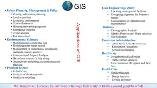
  • 1. • Urban Planning, Management & Policy • Zoning, subdivision planning • Land acquisition • Economic development • Code enforcement • Housing renovation programs • Emergency response • Crime analysis • Tax assessment • Environmental Sciences • Monitoring environmental risk • Modeling storm water runoff • Management of watersheds, floodplains, wetlands, forests, aquifers • Environmental Impact Analysis • Hazardous or toxic facility siting • Groundwater modeling and contamination tracking • Political Science • Redistricting • Analysis of election results • Predictive modeling Civil Engineering/Utility • Locating underground facilities • Designing alignment for freeways, transit • Coordination of infrastructure maintenance Business • Demographic Analysis • Market Penetration/ Share Analysis • Site Selection Education Administration • Attendance Area Maintenance • Enrollment Projections • School Bus Routing Real Estate • Neighborhood land prices • Traffic Impact Analysis • Determination of Highest and Best Use Health Care • Epidemiology • Needs Analysis • Service Inventory ApplicationsofGIS GIS Md. Yousuf Gazi, Lecturer, Department of Geology, University of Dhaka (yousuf.geo@du.ac.bd)
  • 2. • Zoning, subdivision planning • Land acquisition GIS Md. Yousuf Gazi, Lecturer, Department of Geology, University of Dhaka (yousuf.geo@du.ac.bd)
  • 3. • Economic development • Housing renovation programsGIS Md. Yousuf Gazi, Lecturer, Department of Geology, University of Dhaka (yousuf.geo@du.ac.bd)
  • 4. • Code enforcement • Emergency response GIS Md. Yousuf Gazi, Lecturer, Department of Geology, University of Dhaka (yousuf.geo@du.ac.bd)
  • 5. • Crime analysis • Tax assessment GIS Md. Yousuf Gazi, Lecturer, Department of Geology, University of Dhaka (yousuf.geo@du.ac.bd)
  • 6. • Monitoring environmental risk • Modeling storm water runoff GIS Md. Yousuf Gazi, Lecturer, Department of Geology, University of Dhaka (yousuf.geo@du.ac.bd)
  • 7. • Management of watersheds, floodplains, wetlands, forests, aquifers • Environmental Impact Analysis GIS Md. Yousuf Gazi, Lecturer, Department of Geology, University of Dhaka (yousuf.geo@du.ac.bd)
  • 8. • Hazardous or toxic facility siting • Groundwater modeling and contamination tracking GIS Md. Yousuf Gazi, Lecturer, Department of Geology, University of Dhaka (yousuf.geo@du.ac.bd)
  • 9. • Analysis of election results • Redistricting GIS Md. Yousuf Gazi, Lecturer, Department of Geology, University of Dhaka (yousuf.geo@du.ac.bd)
  • 10. • Predictive modeling • Locating underground facilitiesGIS Md. Yousuf Gazi, Lecturer, Department of Geology, University of Dhaka (yousuf.geo@du.ac.bd)
  • 11. • Designing alignment for freeways, transit • Coordination of infrastructure maintenance GIS Md. Yousuf Gazi, Lecturer, Department of Geology, University of Dhaka (yousuf.geo@du.ac.bd)
  • 12. • Demographic Analysis • Market Penetration/ Share Analysis GIS Md. Yousuf Gazi, Lecturer, Department of Geology, University of Dhaka (yousuf.geo@du.ac.bd)
  • 13. • Site Selection • Attendance Area MaintenanceGIS Md. Yousuf Gazi, Lecturer, Department of Geology, University of Dhaka (yousuf.geo@du.ac.bd)
  • 14. • School Bus Routing • Neighborhood land prices GIS Md. Yousuf Gazi, Lecturer, Department of Geology, University of Dhaka (yousuf.geo@du.ac.bd)
  • 15. • Traffic Impact Analysis • Epidemiology GIS Md. Yousuf Gazi, Lecturer, Department of Geology, University of Dhaka (yousuf.geo@du.ac.bd)
  • 16. GIS Md. Yousuf Gazi, Lecturer, Department of Geology, University of Dhaka (yousuf.geo@du.ac.bd)