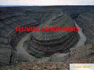
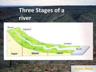
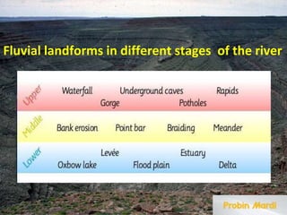
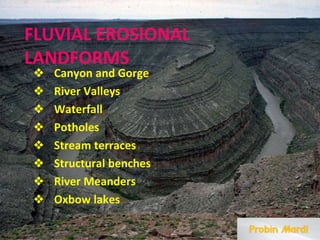
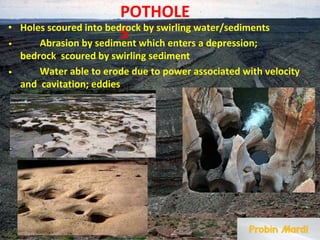
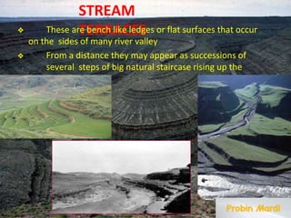
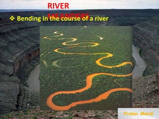
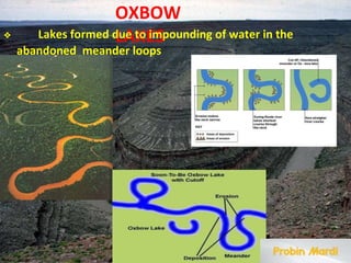
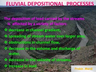
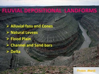
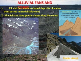
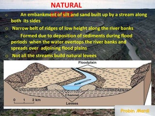
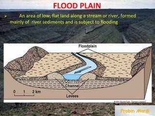
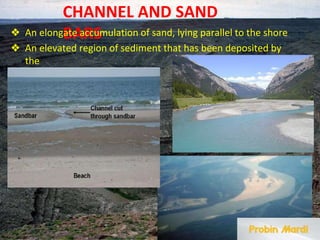
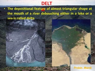
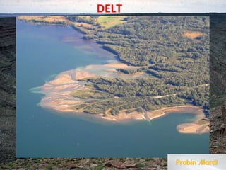
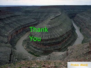
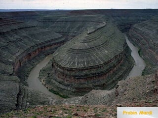
Submitted for the fulfillment of FYUGP
Fluvial Landforms
Geography (Major)
Paper: C1- Geomorphology
Under Dibrugarh University
Submitted by:
Name: Probin Mardi
Semester: 1st Semester ,Rollno.:53
Department: Geography
Session: 2023-24
Borholla College
FLUVIAL LANDFORMS
Three Stages of a
river
Fluvial landforms in different stages of the river
FLUVIAL EROSIONAL
LANDFORMS
❖ Canyon and Gorge
❖ River Valleys
❖ Waterfall
❖ Potholes
❖ Stream terraces
❖ Structural benches
❖ River Meanders
❖ Oxbow lakes
WATERFAL
L
⮚ A waterfall is when a river falls over a
vertical slope.
⮚ It is found in the youth stage of a river where
there are areas of hard and soft rocks.
Canyon and
Gorge
✔ Canyon (US) or
Gorge (Europe)
represents very deep
and narrow
having
valley
very
side
are mostly
valleys
steep
slopes.
✔ They
formed when the
process of
forming a
repeate
d as the
retreats
waterfall
is
frequently,
waterfall
upstream
RIVER
VALLEYS
An elongated
ranges
lowland
of
between
mountains
, uplands,
hills,
often
or
ot
her
having
a river or stream
running along the
bottom
It is typically a low-lying area of land, surrounded by
higher areas such as mountains or hills. It can also be seen
as a path between two mountains, or a depression in a
single mountain.
POTHOLE
S
• Holes scoured into bedrock by swirling water/sediments
• Abrasion by sediment which enters a depression;
bedrock scoured by swirling sediment
• Water able to erode due to power associated with velocity
and cavitation; eddies
STREAM
TERRACES
❖ These are bench like ledges or flat surfaces that occur
on the sides of many river valley
❖ From a distance they may appear as successions of
several steps of big natural staircase rising up the
river bed
RIVER
MEANDERS
❖ Bending in the course of a river
OXBOW
LAKES
❖ Lakes formed due to impounding of water in the
abandoned meander loops
FLUVIAL DEPOSITIONAL PROCESSES
The deposition of load carried by the streams
is affected by a variety of factors:
❖ decrease in channel gradient,
❖ spreading of stream water over larger area,
❖ obstructions in channel flow,
❖ decrease in the volume and discharge of
water,
❖ decrease in the velocity of streams,
❖ increase in load.
FLUVIAL DEPOSITIONAL LANDFORMS
⮚ Alluvial fans and Cones
⮚ Natural Levees
⮚ Flood Plain
⮚ Channel and Sand bars
⮚ Delta
ALLUVIAL FANS AND
CONES
❑ Alluvial fans are fan-shaped deposits of water-
transported material (alluvium)
❑ Alluvial fans have gentler slopes than the cones
a.
NATURAL
LEVEES
o An embankment of silt and sand built up by a stream along
both its sides
o Narrow belt of ridges of low height along the river banks
o Formed due to deposition of sediments during flood
periods when the water overtops the river banks and
spreads over adjoining flood plains
o Not all the streams build natural levees
FLOOD PLAIN
⮚ An area of low, flat land along a stream or river, formed
mainly of river sediments and is subject to flooding
CHANNEL AND SAND
BARS
❖ An elongate accumulation of sand, lying parallel to the shore
❖ An elevated region of sediment that has been deposited by
the
flow
DELT
A
• The depositional feature of almost triangular shape at
the mouth of a river debouching either in a lake or a
sea is called delta
DELT
A
Thank
You
fluvial_landforms.pptx, Geomorphology, Geography

fluvial_landforms.pptx, Geomorphology, Geography

  • 1.
    Submitted for thefulfillment of FYUGP Fluvial Landforms Geography (Major) Paper: C1- Geomorphology Under Dibrugarh University Submitted by: Name: Probin Mardi Semester: 1st Semester ,Rollno.:53 Department: Geography Session: 2023-24 Borholla College
  • 2.
  • 3.
  • 4.
    Fluvial landforms indifferent stages of the river
  • 5.
    FLUVIAL EROSIONAL LANDFORMS ❖ Canyonand Gorge ❖ River Valleys ❖ Waterfall ❖ Potholes ❖ Stream terraces ❖ Structural benches ❖ River Meanders ❖ Oxbow lakes
  • 6.
    WATERFAL L ⮚ A waterfallis when a river falls over a vertical slope. ⮚ It is found in the youth stage of a river where there are areas of hard and soft rocks.
  • 7.
    Canyon and Gorge ✔ Canyon(US) or Gorge (Europe) represents very deep and narrow having valley very side are mostly valleys steep slopes. ✔ They formed when the process of forming a repeate d as the retreats waterfall is frequently, waterfall upstream
  • 8.
    RIVER VALLEYS An elongated ranges lowland of between mountains , uplands, hills, often or ot her having ariver or stream running along the bottom It is typically a low-lying area of land, surrounded by higher areas such as mountains or hills. It can also be seen as a path between two mountains, or a depression in a single mountain.
  • 9.
    POTHOLE S • Holes scouredinto bedrock by swirling water/sediments • Abrasion by sediment which enters a depression; bedrock scoured by swirling sediment • Water able to erode due to power associated with velocity and cavitation; eddies
  • 10.
    STREAM TERRACES ❖ These arebench like ledges or flat surfaces that occur on the sides of many river valley ❖ From a distance they may appear as successions of several steps of big natural staircase rising up the river bed
  • 11.
    RIVER MEANDERS ❖ Bending inthe course of a river
  • 12.
    OXBOW LAKES ❖ Lakes formeddue to impounding of water in the abandoned meander loops
  • 13.
    FLUVIAL DEPOSITIONAL PROCESSES Thedeposition of load carried by the streams is affected by a variety of factors: ❖ decrease in channel gradient, ❖ spreading of stream water over larger area, ❖ obstructions in channel flow, ❖ decrease in the volume and discharge of water, ❖ decrease in the velocity of streams, ❖ increase in load.
  • 14.
    FLUVIAL DEPOSITIONAL LANDFORMS ⮚Alluvial fans and Cones ⮚ Natural Levees ⮚ Flood Plain ⮚ Channel and Sand bars ⮚ Delta
  • 15.
    ALLUVIAL FANS AND CONES ❑Alluvial fans are fan-shaped deposits of water- transported material (alluvium) ❑ Alluvial fans have gentler slopes than the cones a.
  • 16.
    NATURAL LEVEES o An embankmentof silt and sand built up by a stream along both its sides o Narrow belt of ridges of low height along the river banks o Formed due to deposition of sediments during flood periods when the water overtops the river banks and spreads over adjoining flood plains o Not all the streams build natural levees
  • 17.
    FLOOD PLAIN ⮚ Anarea of low, flat land along a stream or river, formed mainly of river sediments and is subject to flooding
  • 18.
    CHANNEL AND SAND BARS ❖An elongate accumulation of sand, lying parallel to the shore ❖ An elevated region of sediment that has been deposited by the flow
  • 19.
    DELT A • The depositionalfeature of almost triangular shape at the mouth of a river debouching either in a lake or a sea is called delta
  • 20.
  • 21.