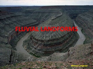
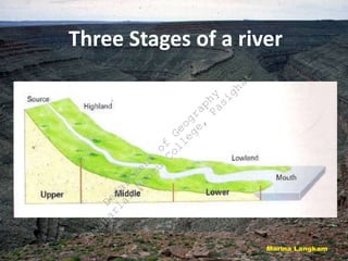
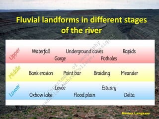
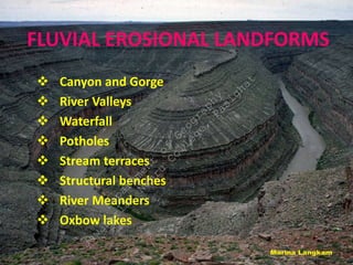
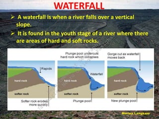
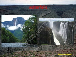
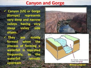
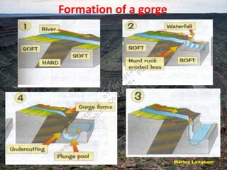
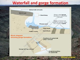
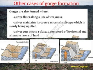
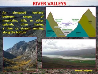
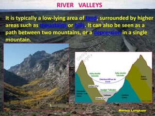
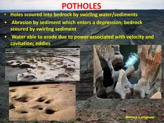
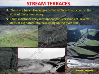
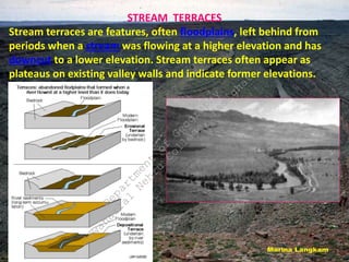
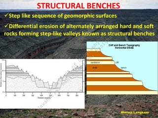
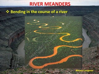
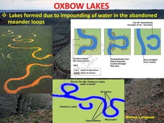
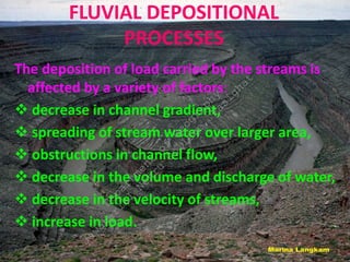
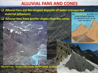
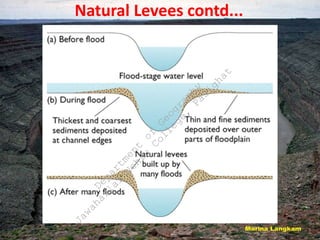
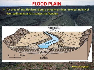
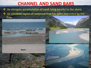
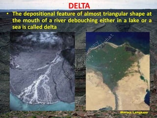
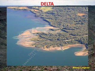
FLUVIAL LANDFORMS
D
e
p
a
r
t
m
e
n
t
o
f
G
e
o
g
r
a
p
h
y
J
a
w
a
h
a
r
l
a
l
N
e
h
r
u
C
o
l
l
e
g
e
,
P
a
s
i
g
h
a
t
Three Stages of a river
D
e
p
a
r
t
m
e
n
t
o
f
G
e
o
g
r
a
p
h
y
J
a
w
a
h
a
r
l
a
l
N
e
h
r
u
C
o
l
l
e
g
e
,
P
a
s
i
g
h
a
t
Fluvial landforms in different stages
of the river
D
e
p
a
r
t
m
e
n
t
o
f
G
e
o
g
r
a
p
h
y
J
a
w
a
h
a
r
l
a
l
N
e
h
r
u
C
o
l
l
e
g
e
,
P
a
s
i
g
h
a
t
FLUVIAL EROSIONAL LANDFORMS
 Canyon and Gorge
 River Valleys
 Waterfall
 Potholes
 Stream terraces
 Structural benches
 River Meanders
 Oxbow lakes
D
e
p
a
r
t
m
e
n
t
o
f
G
e
o
g
r
a
p
h
y
J
a
w
a
h
a
r
l
a
l
N
e
h
r
u
C
o
l
l
e
g
e
,
P
a
s
i
g
h
a
t
WATERFALL
 A waterfall is when a river falls over a vertical
slope.
 It is found in the youth stage of a river where there
are areas of hard and soft rocks.
D
e
p
a
r
t
m
e
n
t
o
f
G
e
o
g
r
a
p
h
y
J
a
w
a
h
a
r
l
a
l
N
e
h
r
u
C
o
l
l
e
g
e
,
P
a
s
i
g
h
a
t
waterfalls
D
e
p
a
r
t
m
e
n
t
o
f
G
e
o
g
r
a
p
h
y
J
a
w
a
h
a
r
l
a
l
N
e
h
r
u
C
o
l
l
e
g
e
,
P
a
s
i
g
h
a
t
Canyon and Gorge
 Canyon (US) or Gorge
(Europe) represents
very deep and narrow
valleys having very
steep valley side
slopes.
 They are mostly
formed when the
process of forming a
waterfall is repeated
frequently, as the
waterfall retreats
upstream
D
e
p
a
r
t
m
e
n
t
o
f
G
e
o
g
r
a
p
h
y
J
a
w
a
h
a
r
l
a
l
N
e
h
r
u
C
o
l
l
e
g
e
,
P
a
s
i
g
h
a
t
Formation of a gorge
D
e
p
a
r
t
m
e
n
t
o
f
G
e
o
g
r
a
p
h
y
J
a
w
a
h
a
r
l
a
l
N
e
h
r
u
C
o
l
l
e
g
e
,
P
a
s
i
g
h
a
t
Waterfall and gorge formation
D
e
p
a
r
t
m
e
n
t
o
f
G
e
o
g
r
a
p
h
y
J
a
w
a
h
a
r
l
a
l
N
e
h
r
u
C
o
l
l
e
g
e
,
P
a
s
i
g
h
a
t
Other cases of gorge formation
D
e
p
a
r
t
m
e
n
t
o
f
G
e
o
g
r
a
p
h
y
J
a
w
a
h
a
r
l
a
l
N
e
h
r
u
C
o
l
l
e
g
e
,
P
a
s
i
g
h
a
t
RIVER VALLEYS
An elongated lowland
between ranges of
mountains, hills, or other
uplands, often having
a river or stream running
along the bottom
D
e
p
a
r
t
m
e
n
t
o
f
G
e
o
g
r
a
p
h
y
J
a
w
a
h
a
r
l
a
l
N
e
h
r
u
C
o
l
l
e
g
e
,
P
a
s
i
g
h
a
t
RIVER VALLEYS
It is typically a low-lying area of land, surrounded by higher
areas such as mountains or hills. It can also be seen as a
path between two mountains, or a depression in a single
mountain.
D
e
p
a
r
t
m
e
n
t
o
f
G
e
o
g
r
a
p
h
y
J
a
w
a
h
a
r
l
a
l
N
e
h
r
u
C
o
l
l
e
g
e
,
P
a
s
i
g
h
a
t
POTHOLES
• Holes scoured into bedrock by swirling water/sediments
• Abrasion by sediment which enters a depression; bedrock
scoured by swirling sediment
• Water able to erode due to power associated with velocity and
cavitation; eddies
D
e
p
a
r
t
m
e
n
t
o
f
G
e
o
g
r
a
p
h
y
J
a
w
a
h
a
r
l
a
l
N
e
h
r
u
C
o
l
l
e
g
e
,
P
a
s
i
g
h
a
t
STREAM TERRACES
 These are bench like ledges or flat surfaces that occur on the
sides of many river valley
 From a distance they may appear as successions of several
steps of big natural staircase rising up the river bed
D
e
p
a
r
t
m
e
n
t
o
f
G
e
o
g
r
a
p
h
y
J
a
w
a
h
a
r
l
a
l
N
e
h
r
u
C
o
l
l
e
g
e
,
P
a
s
i
g
h
a
t
STREAM TERRACES
Stream terraces are features, often floodplains, left behind from
periods when a stream was flowing at a higher elevation and has
downcut to a lower elevation. Stream terraces often appear as
plateaus on existing valley walls and indicate former elevations.
D
e
p
a
r
t
m
e
n
t
o
f
G
e
o
g
r
a
p
h
y
J
a
w
a
h
a
r
l
a
l
N
e
h
r
u
C
o
l
l
e
g
e
,
P
a
s
i
g
h
a
t
STRUCTURAL BENCHES
Step like sequence of geomorphic surfaces
Differential erosion of alternately arranged hard and soft
rocks forming step-like valleys known as structural benches
D
e
p
a
r
t
m
e
n
t
o
f
G
e
o
g
r
a
p
h
y
J
a
w
a
h
a
r
l
a
l
N
e
h
r
u
C
o
l
l
e
g
e
,
P
a
s
i
g
h
a
t
RIVER MEANDERS
 Bending in the course of a river
D
e
p
a
r
t
m
e
n
t
o
f
G
e
o
g
r
a
p
h
y
J
a
w
a
h
a
r
l
a
l
N
e
h
r
u
C
o
l
l
e
g
e
,
P
a
s
i
g
h
a
t
OXBOW LAKES
 Lakes formed due to impounding of water in the abandoned
meander loops
D
e
p
a
r
t
m
e
n
t
o
f
G
e
o
g
r
a
p
h
y
J
a
w
a
h
a
r
l
a
l
N
e
h
r
u
C
o
l
l
e
g
e
,
P
a
s
i
g
h
a
t
FLUVIAL DEPOSITIONAL
PROCESSES
The deposition of load carried by the streams is
affected by a variety of factors:
 decrease in channel gradient,
 spreading of stream water over larger area,
 obstructions in channel flow,
 decrease in the volume and discharge of water,
 decrease in the velocity of streams,
 increase in load.
D
e
p
a
r
t
m
e
n
t
o
f
G
e
o
g
r
a
p
h
y
J
a
w
a
h
a
r
l
a
l
N
e
h
r
u
C
o
l
l
e
g
e
,
P
a
s
i
g
h
a
t
FLUVIAL DEPOSITIONAL
LANDFORMS
 Alluvial fans and Cones
 Natural Levees
 Flood Plain
 Channel and Sand bars
 Delta
D
e
p
a
r
t
m
e
n
t
o
f
G
e
o
g
r
a
p
h
y
J
a
w
a
h
a
r
l
a
l
N
e
h
r
u
C
o
l
l
e
g
e
,
P
a
s
i
g
h
a
t
ALLUVIAL FANS AND CONES
 Alluvial fans are fan-shaped deposits of water-transported
material (alluvium)
 Alluvial fans have gentler slopes than the cones
Alluvial Fans - Brodeur Peninsula, Baffin Island, Canada.
D
e
p
a
r
t
m
e
n
t
o
f
G
e
o
g
r
a
p
h
y
J
a
w
a
h
a
r
l
a
l
N
e
h
r
u
C
o
l
l
e
g
e
,
P
a
s
i
g
h
a
t
NATURAL LEVEES
o An embankment of silt and sand built up by a stream along both
its sides
o Narrow belt of ridges of low height along the river banks
o Formed due to deposition of sediments during flood periods
when the water overtops the river banks and spreads over
adjoining flood plains
o Not all the streams build natural levees
D
e
p
a
r
t
m
e
n
t
o
f
G
e
o
g
r
a
p
h
y
J
a
w
a
h
a
r
l
a
l
N
e
h
r
u
C
o
l
l
e
g
e
,
P
a
s
i
g
h
a
t
Natural Levees contd...
D
e
p
a
r
t
m
e
n
t
o
f
G
e
o
g
r
a
p
h
y
J
a
w
a
h
a
r
l
a
l
N
e
h
r
u
C
o
l
l
e
g
e
,
P
a
s
i
g
h
a
t
FLOOD PLAIN
 An area of low, flat land along a stream or river, formed mainly of
river sediments and is subject to flooding
D
e
p
a
r
t
m
e
n
t
o
f
G
e
o
g
r
a
p
h
y
J
a
w
a
h
a
r
l
a
l
N
e
h
r
u
C
o
l
l
e
g
e
,
P
a
s
i
g
h
a
t
CHANNEL AND SAND BARS
 An elongate accumulation of sand, lying parallel to the shore
 An elevated region of sediment that has been deposited by the
flow
D
e
p
a
r
t
m
e
n
t
o
f
G
e
o
g
r
a
p
h
y
J
a
w
a
h
a
r
l
a
l
N
e
h
r
u
C
o
l
l
e
g
e
,
P
a
s
i
g
h
a
t
DELTA
• The depositional feature of almost triangular shape at
the mouth of a river debouching either in a lake or a
sea is called delta
D
e
p
a
r
t
m
e
n
t
o
f
G
e
o
g
r
a
p
h
y
J
a
w
a
h
a
r
l
a
l
N
e
h
r
u
C
o
l
l
e
g
e
,
P
a
s
i
g
h
a
t
DELTA
D
e
p
a
r
t
m
e
n
t
o
f
G
e
o
g
r
a
p
h
y
J
a
w
a
h
a
r
l
a
l
N
e
h
r
u
C
o
l
l
e
g
e
,
P
a
s
i
g
h
a
t
Thank You
D
e
p
a
r
t
m
e
n
t
o
f
G
e
o
g
r
a
p
h
y
J
a
w
a
h
a
r
l
a
l
N
e
h
r
u
C
o
l
l
e
g
e
,
P
a
s
i
g
h
a
t

fluvial_landforms, Geography, Geomorphology

  • 1.
  • 2.
    Three Stages ofa river D e p a r t m e n t o f G e o g r a p h y J a w a h a r l a l N e h r u C o l l e g e , P a s i g h a t
  • 3.
    Fluvial landforms indifferent stages of the river D e p a r t m e n t o f G e o g r a p h y J a w a h a r l a l N e h r u C o l l e g e , P a s i g h a t
  • 4.
    FLUVIAL EROSIONAL LANDFORMS Canyon and Gorge  River Valleys  Waterfall  Potholes  Stream terraces  Structural benches  River Meanders  Oxbow lakes D e p a r t m e n t o f G e o g r a p h y J a w a h a r l a l N e h r u C o l l e g e , P a s i g h a t
  • 5.
    WATERFALL  A waterfallis when a river falls over a vertical slope.  It is found in the youth stage of a river where there are areas of hard and soft rocks. D e p a r t m e n t o f G e o g r a p h y J a w a h a r l a l N e h r u C o l l e g e , P a s i g h a t
  • 6.
  • 7.
    Canyon and Gorge Canyon (US) or Gorge (Europe) represents very deep and narrow valleys having very steep valley side slopes.  They are mostly formed when the process of forming a waterfall is repeated frequently, as the waterfall retreats upstream D e p a r t m e n t o f G e o g r a p h y J a w a h a r l a l N e h r u C o l l e g e , P a s i g h a t
  • 8.
    Formation of agorge D e p a r t m e n t o f G e o g r a p h y J a w a h a r l a l N e h r u C o l l e g e , P a s i g h a t
  • 9.
    Waterfall and gorgeformation D e p a r t m e n t o f G e o g r a p h y J a w a h a r l a l N e h r u C o l l e g e , P a s i g h a t
  • 10.
    Other cases ofgorge formation D e p a r t m e n t o f G e o g r a p h y J a w a h a r l a l N e h r u C o l l e g e , P a s i g h a t
  • 11.
    RIVER VALLEYS An elongatedlowland between ranges of mountains, hills, or other uplands, often having a river or stream running along the bottom D e p a r t m e n t o f G e o g r a p h y J a w a h a r l a l N e h r u C o l l e g e , P a s i g h a t
  • 12.
    RIVER VALLEYS It istypically a low-lying area of land, surrounded by higher areas such as mountains or hills. It can also be seen as a path between two mountains, or a depression in a single mountain. D e p a r t m e n t o f G e o g r a p h y J a w a h a r l a l N e h r u C o l l e g e , P a s i g h a t
  • 13.
    POTHOLES • Holes scouredinto bedrock by swirling water/sediments • Abrasion by sediment which enters a depression; bedrock scoured by swirling sediment • Water able to erode due to power associated with velocity and cavitation; eddies D e p a r t m e n t o f G e o g r a p h y J a w a h a r l a l N e h r u C o l l e g e , P a s i g h a t
  • 14.
    STREAM TERRACES  Theseare bench like ledges or flat surfaces that occur on the sides of many river valley  From a distance they may appear as successions of several steps of big natural staircase rising up the river bed D e p a r t m e n t o f G e o g r a p h y J a w a h a r l a l N e h r u C o l l e g e , P a s i g h a t
  • 15.
    STREAM TERRACES Stream terracesare features, often floodplains, left behind from periods when a stream was flowing at a higher elevation and has downcut to a lower elevation. Stream terraces often appear as plateaus on existing valley walls and indicate former elevations. D e p a r t m e n t o f G e o g r a p h y J a w a h a r l a l N e h r u C o l l e g e , P a s i g h a t
  • 16.
    STRUCTURAL BENCHES Step likesequence of geomorphic surfaces Differential erosion of alternately arranged hard and soft rocks forming step-like valleys known as structural benches D e p a r t m e n t o f G e o g r a p h y J a w a h a r l a l N e h r u C o l l e g e , P a s i g h a t
  • 17.
    RIVER MEANDERS  Bendingin the course of a river D e p a r t m e n t o f G e o g r a p h y J a w a h a r l a l N e h r u C o l l e g e , P a s i g h a t
  • 18.
    OXBOW LAKES  Lakesformed due to impounding of water in the abandoned meander loops D e p a r t m e n t o f G e o g r a p h y J a w a h a r l a l N e h r u C o l l e g e , P a s i g h a t
  • 19.
    FLUVIAL DEPOSITIONAL PROCESSES The depositionof load carried by the streams is affected by a variety of factors:  decrease in channel gradient,  spreading of stream water over larger area,  obstructions in channel flow,  decrease in the volume and discharge of water,  decrease in the velocity of streams,  increase in load. D e p a r t m e n t o f G e o g r a p h y J a w a h a r l a l N e h r u C o l l e g e , P a s i g h a t
  • 20.
    FLUVIAL DEPOSITIONAL LANDFORMS  Alluvialfans and Cones  Natural Levees  Flood Plain  Channel and Sand bars  Delta D e p a r t m e n t o f G e o g r a p h y J a w a h a r l a l N e h r u C o l l e g e , P a s i g h a t
  • 21.
    ALLUVIAL FANS ANDCONES  Alluvial fans are fan-shaped deposits of water-transported material (alluvium)  Alluvial fans have gentler slopes than the cones Alluvial Fans - Brodeur Peninsula, Baffin Island, Canada. D e p a r t m e n t o f G e o g r a p h y J a w a h a r l a l N e h r u C o l l e g e , P a s i g h a t
  • 22.
    NATURAL LEVEES o Anembankment of silt and sand built up by a stream along both its sides o Narrow belt of ridges of low height along the river banks o Formed due to deposition of sediments during flood periods when the water overtops the river banks and spreads over adjoining flood plains o Not all the streams build natural levees D e p a r t m e n t o f G e o g r a p h y J a w a h a r l a l N e h r u C o l l e g e , P a s i g h a t
  • 23.
  • 24.
    FLOOD PLAIN  Anarea of low, flat land along a stream or river, formed mainly of river sediments and is subject to flooding D e p a r t m e n t o f G e o g r a p h y J a w a h a r l a l N e h r u C o l l e g e , P a s i g h a t
  • 25.
    CHANNEL AND SANDBARS  An elongate accumulation of sand, lying parallel to the shore  An elevated region of sediment that has been deposited by the flow D e p a r t m e n t o f G e o g r a p h y J a w a h a r l a l N e h r u C o l l e g e , P a s i g h a t
  • 26.
    DELTA • The depositionalfeature of almost triangular shape at the mouth of a river debouching either in a lake or a sea is called delta D e p a r t m e n t o f G e o g r a p h y J a w a h a r l a l N e h r u C o l l e g e , P a s i g h a t
  • 27.
  • 28.