Downloaded 146 times


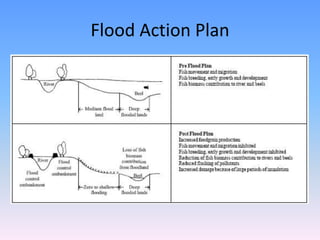


This document discusses flood management strategies in three paragraphs. Hard engineering approaches like dams and levees are mentioned, as well as soft engineering approaches like floodplain management and river restoration. It then provides details on Bangladesh's Flood Action Plan, which relies on embankments along major rivers to control flooding while still allowing benefits from floodwaters. However, opposition to embankments is growing due to problems they can cause by preventing natural drainage. Overall, the document outlines both hard and soft flood management techniques, and summarizes Bangladesh's current national flood control strategy of using embankments.