SlideShare a Scribd company logo
1 of 30
Flooding in Bangladesh

Key idea:
The effects of and responses to floods vary
between areas of contrasting levels of wealth
Lesson objectives
• To study a case study of flooding from a
  poorer part of the world - Bangladesh
• To know the effects of flooding
• To know the responses to the frequent
  flooding event
Starter activity….
Sketch the map below and label the countries:


        China

        India

        Nepal

        Bangladesh

        Pakistan

        Bhutan

        Burma
        (Myanmar)
EXPLORE: Bangladesh
flooding


Almost all of Bangladesh’s
rivers have their source outside
the country.
Bangladesh has three mighty rivers, the Ganges,
the Jamuna and the Meghna
Freshwater
floods occur
when a
watershed
receives so
much water
that it cannot
drain into the
soil quickly
enough to take
the water
away..
Most floods follow heavy rain or melting snow,
frozen ground and already high river levels.


The floods in Bangladesh begin through a
combination of heavy monsoon rains flooding
the rivers and abnormally high tides in the
Bay of Bengal preventing floodwater from
running off the land and into the sea.
The deltas of the Ganges and Brahmaputra rivers in South
Asia flood on a seasonal basis. The flooding keeps the soil
fertile because the rivers deposit silt which forms fertile soil
each year. Partly because of the flooding, it is one of the most
densely populated areas of the world (900 people per km2).
Millions of people in Nepal, Northern India and Bangladesh
depend on the rivers and fertile soils for their livelihoods.
Tear Fund UK
Where does the flooding occur?
Identify specific regions that are worst hit.
80% of Bangladesh is
located on the delta.
The low level of the
delta land means that
large areas are prone to
flooding. 75% of
Bangladesh is at or
below just 10 metres in
height.
Total rainfall within the Brahmaputra, Ganges – Meghna
catchment is very high and very seasonal. 75% of annual
rainfall occurs in the monsoon between June and September.
Annual rainfall total in Dhaka is almost 2000mm
Tropical cyclones from Bay of Bengal bring heavy rain and
storm waves in late summer
Bangladesh also suffers
regularly from
substantial flooding
melting snows from the
Himalayas.

Source: World
Infozone.com
Human factors that cause
                flooding
• Deforestation may be partly to blame, stripping the land bare of
  the vital top soil which slows and drains water. This causes soil
  erosion which reduces the ability of the land to absorb water.

• Irrigation for farming is a factor, because this causes river
  channels to silt up, reducing their capacity to hold flood waters.
  According to some experts, irrigation interferes with river
  drainage into the sea.

• Climate experts also believe global warming is partly to blame,
  by increasing monsoon rainfall and speeding up the melting of
  Himalayan snows.

• In built-up areas with a lot of concrete roads and houses, there
  are fewer places for water to go and less soil for water to drain
  into. Planners in cities prone to flooding have to develop ways of
  channelling water to cope with potential floods.
Bangladesh - Fact File

• is one of the world's most densely populated
  countries!
• has a population of 125m inhabitants
• is one of the poorest countries in the world with a
  GNP of $200 per head
• has three of the world's most powerful rivers passing
  through its country - The Ganges, the Meghna & the
  Brahmaputra
• contains virtually no raw materials or rock
• experiences floods and tropical storms every year
The Physical Causes of the
              Floods
• Most of the country consists of a huge flood plain and
  delta . 70% of the total area is less than 1 metre
  above sea level
• 10% of the land area is made up of Lakes and Rivers
• Snowmelt from the Himalayas takes place in late
  spring & summer
• Bangladesh experiences heavy monsoon rains,
  especially over the highlands
• Tropical storms bring heavy rains and coastal flooding
• The main cause was the above average & long period
  of heavy rain which caused all 3 rivers to have their
  peak flow at the same time!!!
The Human Causes of the
             Floods
• Deforestation in Nepal and the Himalayas increases
  run off and adds to deposition and flooding
  downstream
• Urbanisation of the flood plain has increased
  magnitude & frequency of floods
• the building of dams in India has increased the
  problem of sedimentation in Bangladesh
• Global warming is blamed for sea level rise, increased
  snow melt & increased rainfall in the region
• Poorly maintained embankments (levees) leak &
  collapse in times of high discharge
The Effects of the 1998 Floods

•   Over 57% of the land area was flooded
•   Over 1300 people were killed
•   7 million homes were destroyed
•   25 million people were made homeless
•   There was a serious shortage of drinking water & dry
    food
•   Diseases spread such as bronchitis and
    cholera/diarrhoea
•   As the waters receded - it left fields of rotting
    crops, wrecked roads and bridges and destroyed
    villages
•   2 million tonnes of rice was destroyed
•   1/2 million cattle and poultry were lost
floods occurred July to Sept         Airport, roads and railways
                                     flooded
July 2004 - 40% Dhaka was under
                                     Bridges destroyed
water
                                     $7billion damage
60% of country was flooded           Rice crop destroyed along with
                                     food supplies – vegetables
600 reporte deaths
                                     Cash crops – jute and sugar
20 million homeless
100,000 in Dhaka suffered from
diarrhoea as floodlwaters left mud
and sewage
35cm of rain fell in 1 day on 13th
                                                Textbook
Sept                                            page 115
Death toll rose to 750
Is flooding in Bangladesh always a
             bad thing?
During the monsoon, between 30% and
 50% of the entire country is flooded.
 The flood waters:
• Replenish groundwater reserves
• Provide nutrient rich sediment for
  farming
• Provide fish
• Reduce the need for artificial
  fertilisers
Responses
• Bangladesh GNP US$ 380 per capita
• Short term concern is always for health survival and
  suffering of people affected.
• A heavy reliance is placed upon emergency aid – food,
  drinking water medicines, plastic sheets, boats
• Assistance is provided from United Nations,
  governments, charities
• Problem is distribution because so much of the
  country is underwater.
• As flood water recedes it is easier to set up medical
  treatment centres, distribute water purification
  tablets and provide help with repairing homes and
  restarting economic activities
In 1989  the government of Bangladesh began working with a number of
   international agencies to produce a Flood Action Plan. This huge
   scheme contained 26 action points which it was hoped would provide a
   long term solution to the country's flooding problems.

Short Term Management
• Boats to rescue people
• Emergency supplies for food, water, tents and medicines
• Fodder for livestock
• Repair and rebuild houses, as well as services such as sewage etc
• Aid from other countries

Long Term Management
• Reduce Deforestation in Nepal & Himalayas
• Build 7 large dams in Bangladesh to store excess water $30-$40 million
   and 40 yrs to complete
• Build 5000 flood shelters to accommodate all the population
• Build 350km of embankment - 7 metres high at a cost of $6 billion to
   reduce flooding along the main river channels
• Create flood water storage areas
• Develop an effective Flood Warning Scheme
How have decision makers respond to the flooding?
The Flood Action Plan (FAP) was set up in 1990 supported by several wealthy
countries and the World Bank. Its aim was to reduce the impact of the
floods that occurred annually in Bangladesh.

The FAP’s objectives were to set up regional planning groups to study and
monitor local river processes, followed by hard engineering aproaches. This
involved the construction of 3,500km of coastal and river embankments to
protect the land and to protect from storm surges brought by cyclones.
The project included building seven large dams partly to stop water from
reaching the land and to provide up to 15 floodwater storage basins.
Millions of dollars of aid were poured into the engineering projects but the
scheme remains unfinished due to corruption and inadequate funding.

As a result the FAP is not considered to have been a complete success.

Over 3 million people have been killed by coastal flooding in the last 30 years.

The first findings of the FAP in 1995 stated that, while the flood protection
scheme was economically desirable for urban areas, it was not a good idea in
rural areas, which are dependent upon fishing and farming.
What issues are faced in implementing
      strategies in countries like Bangladesh?
    Whilst the embankments have been strengthened,
    increased in height and extended in many places, the
    FAP has come across several problems, such as:


•    The Bangladeshi Government cannot afford the high maintenance costs of
     the scheme
•    The embankments are at risk of erosion from the rivers
•    River channelisation by FAP embankments has increased the risk of flood
     damage for downstream areas
•    An estimated 8 million people were forced to move due to the FAP. These
     were people who relied on farming and fishing to support themselves.

                                                           BBC Bitesize
A sustainable solution?
• People have suggested that
  Bangladesh really needs a mixture of
  strategies involving flood forecasting
  and early warning schemes together
  with more well stocked flood
  shelters.
• These projects would be cheaper
  and more appropriate for farming
  and fishing communities in rural
  areas and would be more in keeping
  with local knowledge, skills and
  income levels and thus more
  sustainable. They would also have
  the advantage of being less likely to
  damage the ecosystems.
Your task:
Imagine you are working as a volunteer for an aid
agency such as Water Aid in Bangladesh during the
floods of 2004. Write a letter home describing the
situation in the floods in Bangladesh, its effects and
responses to it. Try to make your account as real as
possible so that the reader can imagine the
experience. Include photo images, witness accounts
and describe your own thoughts and feelings.
References:
Use the following links to add detail to your
 account:


• Why Bangladesh floods are so bad


• India 'made floods worse'
• Bangladesh floods worsen
• Bangladesh praised for disaster planning

More Related Content

What's hot

Drought management and risk reduction in pakistan) A Presentation By Mr Allah...
Drought management and risk reduction in pakistan) A Presentation By Mr Allah...Drought management and risk reduction in pakistan) A Presentation By Mr Allah...
Drought management and risk reduction in pakistan) A Presentation By Mr Allah...Mr.Allah Dad Khan
 
Bangladesh Climate Change
Bangladesh Climate ChangeBangladesh Climate Change
Bangladesh Climate ChangeMr Cornish
 
Hydrology & Fluvial Geomorphology
Hydrology & Fluvial GeomorphologyHydrology & Fluvial Geomorphology
Hydrology & Fluvial GeomorphologyMalia Damit
 
Floodplain presentation
Floodplain presentationFloodplain presentation
Floodplain presentationOlexiy Dubilet
 
Floods In Bangladesh
Floods In BangladeshFloods In Bangladesh
Floods In Bangladeshwhiskeyhj
 
Aral Sea Detailed Revision
Aral Sea Detailed RevisionAral Sea Detailed Revision
Aral Sea Detailed Revisionjbaynham
 
Rivers Drainage Basin
Rivers Drainage BasinRivers Drainage Basin
Rivers Drainage BasinMrs Coles
 
Geography AS Level full revision notes
Geography AS Level full revision notesGeography AS Level full revision notes
Geography AS Level full revision notesBrittany Farrant
 
River Presentation
River PresentationRiver Presentation
River PresentationMalia Damit
 
Water resource management in Bangladesh
Water resource management in BangladeshWater resource management in Bangladesh
Water resource management in BangladeshAl Jubaer
 
Floodmanagementstrategies
FloodmanagementstrategiesFloodmanagementstrategies
FloodmanagementstrategiesWill Williams
 
Floods in bangladesh
Floods in bangladeshFloods in bangladesh
Floods in bangladeshHanif Bhuian
 
CAMBRIDGE GEOGRAPHY AS - HYDROLOGY AND FLUVIAL GEOMORPHOLOGY; 1.1. DRAINAGE B...
CAMBRIDGE GEOGRAPHY AS - HYDROLOGY AND FLUVIAL GEOMORPHOLOGY; 1.1. DRAINAGE B...CAMBRIDGE GEOGRAPHY AS - HYDROLOGY AND FLUVIAL GEOMORPHOLOGY; 1.1. DRAINAGE B...
CAMBRIDGE GEOGRAPHY AS - HYDROLOGY AND FLUVIAL GEOMORPHOLOGY; 1.1. DRAINAGE B...George Dumitrache
 
River bank erosion, its migration, causes
River bank erosion, its migration, causesRiver bank erosion, its migration, causes
River bank erosion, its migration, causesNazim Naeem
 
Drainage basin hydrological cycle smy
Drainage basin hydrological cycle smyDrainage basin hydrological cycle smy
Drainage basin hydrological cycle smytonybattista
 

What's hot (20)

Drought management and risk reduction in pakistan) A Presentation By Mr Allah...
Drought management and risk reduction in pakistan) A Presentation By Mr Allah...Drought management and risk reduction in pakistan) A Presentation By Mr Allah...
Drought management and risk reduction in pakistan) A Presentation By Mr Allah...
 
Bangladesh floods
Bangladesh floodsBangladesh floods
Bangladesh floods
 
Bangladesh Climate Change
Bangladesh Climate ChangeBangladesh Climate Change
Bangladesh Climate Change
 
Hydrology & Fluvial Geomorphology
Hydrology & Fluvial GeomorphologyHydrology & Fluvial Geomorphology
Hydrology & Fluvial Geomorphology
 
Floodplain presentation
Floodplain presentationFloodplain presentation
Floodplain presentation
 
Fluvial Systems - General
Fluvial Systems - GeneralFluvial Systems - General
Fluvial Systems - General
 
Floods In Bangladesh
Floods In BangladeshFloods In Bangladesh
Floods In Bangladesh
 
GEOGRAPHY IGCSE: RIVERS
GEOGRAPHY IGCSE: RIVERSGEOGRAPHY IGCSE: RIVERS
GEOGRAPHY IGCSE: RIVERS
 
Aral Sea Detailed Revision
Aral Sea Detailed RevisionAral Sea Detailed Revision
Aral Sea Detailed Revision
 
Rivers Drainage Basin
Rivers Drainage BasinRivers Drainage Basin
Rivers Drainage Basin
 
Geography AS Level full revision notes
Geography AS Level full revision notesGeography AS Level full revision notes
Geography AS Level full revision notes
 
River Presentation
River PresentationRiver Presentation
River Presentation
 
Meandering rivers
Meandering riversMeandering rivers
Meandering rivers
 
Water resource management in Bangladesh
Water resource management in BangladeshWater resource management in Bangladesh
Water resource management in Bangladesh
 
Floodmanagementstrategies
FloodmanagementstrategiesFloodmanagementstrategies
Floodmanagementstrategies
 
Floods in bangladesh
Floods in bangladeshFloods in bangladesh
Floods in bangladesh
 
CAMBRIDGE GEOGRAPHY AS - HYDROLOGY AND FLUVIAL GEOMORPHOLOGY; 1.1. DRAINAGE B...
CAMBRIDGE GEOGRAPHY AS - HYDROLOGY AND FLUVIAL GEOMORPHOLOGY; 1.1. DRAINAGE B...CAMBRIDGE GEOGRAPHY AS - HYDROLOGY AND FLUVIAL GEOMORPHOLOGY; 1.1. DRAINAGE B...
CAMBRIDGE GEOGRAPHY AS - HYDROLOGY AND FLUVIAL GEOMORPHOLOGY; 1.1. DRAINAGE B...
 
River bank erosion, its migration, causes
River bank erosion, its migration, causesRiver bank erosion, its migration, causes
River bank erosion, its migration, causes
 
Exogenous disasters drought
Exogenous disasters    droughtExogenous disasters    drought
Exogenous disasters drought
 
Drainage basin hydrological cycle smy
Drainage basin hydrological cycle smyDrainage basin hydrological cycle smy
Drainage basin hydrological cycle smy
 

Similar to Flooding 5 Bangladesh Gcse Aqa A

L9 Bangladesh Gcse Aqa A
L9 Bangladesh Gcse Aqa AL9 Bangladesh Gcse Aqa A
L9 Bangladesh Gcse Aqa Atudorgeog
 
LEDC flooding case study Bangladesh 1998
LEDC flooding case study Bangladesh 1998LEDC flooding case study Bangladesh 1998
LEDC flooding case study Bangladesh 1998Mr Cornish
 
Year 10 presentation
Year 10 presentationYear 10 presentation
Year 10 presentationeshuttleworth
 
Water resources ppt
Water resources pptWater resources ppt
Water resources pptSriVishwalk
 
Krishna Vatsa - Resilience-based approach to Flood Risk Management in South Asia
Krishna Vatsa - Resilience-based approach to Flood Risk Management in South AsiaKrishna Vatsa - Resilience-based approach to Flood Risk Management in South Asia
Krishna Vatsa - Resilience-based approach to Flood Risk Management in South AsiaGlobal Risk Forum GRFDavos
 
L4 risks of water supply
L4 risks of water supplyL4 risks of water supply
L4 risks of water supplyandypinks
 
inter-linking of rivers in india
inter-linking of rivers in indiainter-linking of rivers in india
inter-linking of rivers in indiamanishgalav
 
Essential resource of Life- WATER
Essential resource of Life- WATEREssential resource of Life- WATER
Essential resource of Life- WATERLovely Singla
 
DISASTER MITIGATION &MANAGEMENT: Case study of SURAT Flood As national & Bang...
DISASTER MITIGATION &MANAGEMENT: Case study of SURAT Flood As national & Bang...DISASTER MITIGATION &MANAGEMENT: Case study of SURAT Flood As national & Bang...
DISASTER MITIGATION &MANAGEMENT: Case study of SURAT Flood As national & Bang...NEEL VAGADIA
 
waterresources-150526055815-lva1-app6891.pptx
waterresources-150526055815-lva1-app6891.pptxwaterresources-150526055815-lva1-app6891.pptx
waterresources-150526055815-lva1-app6891.pptxNishathAnjum4
 
C:\fakepath\geography
C:\fakepath\geographyC:\fakepath\geography
C:\fakepath\geography28tom
 
High risk Floods prone area ManagementIndia By B.pptx
High risk Floods prone area ManagementIndia By B.pptxHigh risk Floods prone area ManagementIndia By B.pptx
High risk Floods prone area ManagementIndia By B.pptxB. BHASKAR
 
WATER CRISIS “Prediction of 3rd world war”
WATER CRISIS “Prediction of 3rd world war”WATER CRISIS “Prediction of 3rd world war”
WATER CRISIS “Prediction of 3rd world war”Poonam Singh
 

Similar to Flooding 5 Bangladesh Gcse Aqa A (20)

L9 Bangladesh Gcse Aqa A
L9 Bangladesh Gcse Aqa AL9 Bangladesh Gcse Aqa A
L9 Bangladesh Gcse Aqa A
 
Bangladesh 10 d
Bangladesh 10 dBangladesh 10 d
Bangladesh 10 d
 
LEDC flooding case study Bangladesh 1998
LEDC flooding case study Bangladesh 1998LEDC flooding case study Bangladesh 1998
LEDC flooding case study Bangladesh 1998
 
Year 10 presentation
Year 10 presentationYear 10 presentation
Year 10 presentation
 
Water resources ppt
Water resources pptWater resources ppt
Water resources ppt
 
10 a
10 a10 a
10 a
 
Water
WaterWater
Water
 
Flood.pptx
Flood.pptxFlood.pptx
Flood.pptx
 
Presentation on flood
Presentation on floodPresentation on flood
Presentation on flood
 
Krishna Vatsa - Resilience-based approach to Flood Risk Management in South Asia
Krishna Vatsa - Resilience-based approach to Flood Risk Management in South AsiaKrishna Vatsa - Resilience-based approach to Flood Risk Management in South Asia
Krishna Vatsa - Resilience-based approach to Flood Risk Management in South Asia
 
Flood & Kosi
Flood & KosiFlood & Kosi
Flood & Kosi
 
L4 risks of water supply
L4 risks of water supplyL4 risks of water supply
L4 risks of water supply
 
inter-linking of rivers in india
inter-linking of rivers in indiainter-linking of rivers in india
inter-linking of rivers in india
 
Essential resource of Life- WATER
Essential resource of Life- WATEREssential resource of Life- WATER
Essential resource of Life- WATER
 
Floods
FloodsFloods
Floods
 
DISASTER MITIGATION &MANAGEMENT: Case study of SURAT Flood As national & Bang...
DISASTER MITIGATION &MANAGEMENT: Case study of SURAT Flood As national & Bang...DISASTER MITIGATION &MANAGEMENT: Case study of SURAT Flood As national & Bang...
DISASTER MITIGATION &MANAGEMENT: Case study of SURAT Flood As national & Bang...
 
waterresources-150526055815-lva1-app6891.pptx
waterresources-150526055815-lva1-app6891.pptxwaterresources-150526055815-lva1-app6891.pptx
waterresources-150526055815-lva1-app6891.pptx
 
C:\fakepath\geography
C:\fakepath\geographyC:\fakepath\geography
C:\fakepath\geography
 
High risk Floods prone area ManagementIndia By B.pptx
High risk Floods prone area ManagementIndia By B.pptxHigh risk Floods prone area ManagementIndia By B.pptx
High risk Floods prone area ManagementIndia By B.pptx
 
WATER CRISIS “Prediction of 3rd world war”
WATER CRISIS “Prediction of 3rd world war”WATER CRISIS “Prediction of 3rd world war”
WATER CRISIS “Prediction of 3rd world war”
 

More from tudorgeog

Meeting powerpoint 2016
Meeting powerpoint 2016Meeting powerpoint 2016
Meeting powerpoint 2016tudorgeog
 
Coastal questions
Coastal questionsCoastal questions
Coastal questionstudorgeog
 
Paper 1 revision 29.5.13 bv
Paper 1 revision 29.5.13 bvPaper 1 revision 29.5.13 bv
Paper 1 revision 29.5.13 bvtudorgeog
 
Tourism model answers
Tourism model answersTourism model answers
Tourism model answerstudorgeog
 
Describe how governments are attempting to cope with the problems of an agein...
Describe how governments are attempting to cope with the problems of an agein...Describe how governments are attempting to cope with the problems of an agein...
Describe how governments are attempting to cope with the problems of an agein...tudorgeog
 
Urban model answers
Urban model answersUrban model answers
Urban model answerstudorgeog
 
Iceland 2011 v2 nsr
Iceland 2011 v2 nsrIceland 2011 v2 nsr
Iceland 2011 v2 nsrtudorgeog
 
Mock exam feedback 2011
Mock exam feedback 2011Mock exam feedback 2011
Mock exam feedback 2011tudorgeog
 
Sustainability requires the
Sustainability requires theSustainability requires the
Sustainability requires thetudorgeog
 
Tourism in kenya– good or bad
Tourism in kenya– good or badTourism in kenya– good or bad
Tourism in kenya– good or badtudorgeog
 
Mass tourism – good or bad
Mass tourism – good or badMass tourism – good or bad
Mass tourism – good or badtudorgeog
 
L3 how do we manage tourism in the uk
L3 how do we manage tourism in the ukL3 how do we manage tourism in the uk
L3 how do we manage tourism in the uktudorgeog
 
L2 why has global
L2 why has globalL2 why has global
L2 why has globaltudorgeog
 
L1 why has global tourism grown nsr
L1 why has global tourism grown nsrL1 why has global tourism grown nsr
L1 why has global tourism grown nsrtudorgeog
 
L15 air and water pollution
L15 air and water pollutionL15 air and water pollution
L15 air and water pollutiontudorgeog
 

More from tudorgeog (20)

Meeting powerpoint 2016
Meeting powerpoint 2016Meeting powerpoint 2016
Meeting powerpoint 2016
 
Coastal questions
Coastal questionsCoastal questions
Coastal questions
 
Paper 1 revision 29.5.13 bv
Paper 1 revision 29.5.13 bvPaper 1 revision 29.5.13 bv
Paper 1 revision 29.5.13 bv
 
Model 1
Model 1Model 1
Model 1
 
Model 3
Model 3Model 3
Model 3
 
Model 2
Model 2Model 2
Model 2
 
Tourism model answers
Tourism model answersTourism model answers
Tourism model answers
 
Describe how governments are attempting to cope with the problems of an agein...
Describe how governments are attempting to cope with the problems of an agein...Describe how governments are attempting to cope with the problems of an agein...
Describe how governments are attempting to cope with the problems of an agein...
 
Urban model answers
Urban model answersUrban model answers
Urban model answers
 
Iceland 2011 v2 nsr
Iceland 2011 v2 nsrIceland 2011 v2 nsr
Iceland 2011 v2 nsr
 
Mock exam feedback 2011
Mock exam feedback 2011Mock exam feedback 2011
Mock exam feedback 2011
 
Sustainability requires the
Sustainability requires theSustainability requires the
Sustainability requires the
 
Tourism in kenya– good or bad
Tourism in kenya– good or badTourism in kenya– good or bad
Tourism in kenya– good or bad
 
Mass tourism – good or bad
Mass tourism – good or badMass tourism – good or bad
Mass tourism – good or bad
 
L3 how do we manage tourism in the uk
L3 how do we manage tourism in the ukL3 how do we manage tourism in the uk
L3 how do we manage tourism in the uk
 
L2 why has global
L2 why has globalL2 why has global
L2 why has global
 
L1 why has global tourism grown nsr
L1 why has global tourism grown nsrL1 why has global tourism grown nsr
L1 why has global tourism grown nsr
 
L14 waste
L14 wasteL14 waste
L14 waste
 
L15 air and water pollution
L15 air and water pollutionL15 air and water pollution
L15 air and water pollution
 
Bhopal
BhopalBhopal
Bhopal
 

Flooding 5 Bangladesh Gcse Aqa A

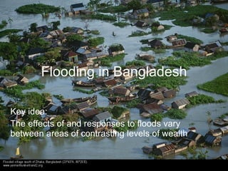
  • 1. Flooding in Bangladesh Key idea: The effects of and responses to floods vary between areas of contrasting levels of wealth
  • 2. Lesson objectives • To study a case study of flooding from a poorer part of the world - Bangladesh • To know the effects of flooding • To know the responses to the frequent flooding event
  • 3. Starter activity…. Sketch the map below and label the countries: China India Nepal Bangladesh Pakistan Bhutan Burma (Myanmar)
  • 5. flooding Almost all of Bangladesh’s rivers have their source outside the country.
  • 6. Bangladesh has three mighty rivers, the Ganges, the Jamuna and the Meghna
  • 7. Freshwater floods occur when a watershed receives so much water that it cannot drain into the soil quickly enough to take the water away..
  • 8. Most floods follow heavy rain or melting snow, frozen ground and already high river levels. The floods in Bangladesh begin through a combination of heavy monsoon rains flooding the rivers and abnormally high tides in the Bay of Bengal preventing floodwater from running off the land and into the sea.
  • 9. The deltas of the Ganges and Brahmaputra rivers in South Asia flood on a seasonal basis. The flooding keeps the soil fertile because the rivers deposit silt which forms fertile soil each year. Partly because of the flooding, it is one of the most densely populated areas of the world (900 people per km2). Millions of people in Nepal, Northern India and Bangladesh depend on the rivers and fertile soils for their livelihoods. Tear Fund UK
  • 10. Where does the flooding occur? Identify specific regions that are worst hit.
  • 11.
  • 12. 80% of Bangladesh is located on the delta. The low level of the delta land means that large areas are prone to flooding. 75% of Bangladesh is at or below just 10 metres in height.
  • 13. Total rainfall within the Brahmaputra, Ganges – Meghna catchment is very high and very seasonal. 75% of annual rainfall occurs in the monsoon between June and September. Annual rainfall total in Dhaka is almost 2000mm Tropical cyclones from Bay of Bengal bring heavy rain and storm waves in late summer
  • 14. Bangladesh also suffers regularly from substantial flooding melting snows from the Himalayas. Source: World Infozone.com
  • 15. Human factors that cause flooding • Deforestation may be partly to blame, stripping the land bare of the vital top soil which slows and drains water. This causes soil erosion which reduces the ability of the land to absorb water. • Irrigation for farming is a factor, because this causes river channels to silt up, reducing their capacity to hold flood waters. According to some experts, irrigation interferes with river drainage into the sea. • Climate experts also believe global warming is partly to blame, by increasing monsoon rainfall and speeding up the melting of Himalayan snows. • In built-up areas with a lot of concrete roads and houses, there are fewer places for water to go and less soil for water to drain into. Planners in cities prone to flooding have to develop ways of channelling water to cope with potential floods.
  • 16.
  • 17. Bangladesh - Fact File • is one of the world's most densely populated countries! • has a population of 125m inhabitants • is one of the poorest countries in the world with a GNP of $200 per head • has three of the world's most powerful rivers passing through its country - The Ganges, the Meghna & the Brahmaputra • contains virtually no raw materials or rock • experiences floods and tropical storms every year
  • 18. The Physical Causes of the Floods • Most of the country consists of a huge flood plain and delta . 70% of the total area is less than 1 metre above sea level • 10% of the land area is made up of Lakes and Rivers • Snowmelt from the Himalayas takes place in late spring & summer • Bangladesh experiences heavy monsoon rains, especially over the highlands • Tropical storms bring heavy rains and coastal flooding • The main cause was the above average & long period of heavy rain which caused all 3 rivers to have their peak flow at the same time!!!
  • 19. The Human Causes of the Floods • Deforestation in Nepal and the Himalayas increases run off and adds to deposition and flooding downstream • Urbanisation of the flood plain has increased magnitude & frequency of floods • the building of dams in India has increased the problem of sedimentation in Bangladesh • Global warming is blamed for sea level rise, increased snow melt & increased rainfall in the region • Poorly maintained embankments (levees) leak & collapse in times of high discharge
  • 20. The Effects of the 1998 Floods • Over 57% of the land area was flooded • Over 1300 people were killed • 7 million homes were destroyed • 25 million people were made homeless • There was a serious shortage of drinking water & dry food • Diseases spread such as bronchitis and cholera/diarrhoea • As the waters receded - it left fields of rotting crops, wrecked roads and bridges and destroyed villages • 2 million tonnes of rice was destroyed • 1/2 million cattle and poultry were lost
  • 21. floods occurred July to Sept Airport, roads and railways flooded July 2004 - 40% Dhaka was under Bridges destroyed water $7billion damage 60% of country was flooded Rice crop destroyed along with food supplies – vegetables 600 reporte deaths Cash crops – jute and sugar 20 million homeless 100,000 in Dhaka suffered from diarrhoea as floodlwaters left mud and sewage 35cm of rain fell in 1 day on 13th Textbook Sept page 115 Death toll rose to 750
  • 22. Is flooding in Bangladesh always a bad thing?
  • 23. During the monsoon, between 30% and 50% of the entire country is flooded. The flood waters: • Replenish groundwater reserves • Provide nutrient rich sediment for farming • Provide fish • Reduce the need for artificial fertilisers
  • 24. Responses • Bangladesh GNP US$ 380 per capita • Short term concern is always for health survival and suffering of people affected. • A heavy reliance is placed upon emergency aid – food, drinking water medicines, plastic sheets, boats • Assistance is provided from United Nations, governments, charities • Problem is distribution because so much of the country is underwater. • As flood water recedes it is easier to set up medical treatment centres, distribute water purification tablets and provide help with repairing homes and restarting economic activities
  • 25. In 1989  the government of Bangladesh began working with a number of international agencies to produce a Flood Action Plan. This huge scheme contained 26 action points which it was hoped would provide a long term solution to the country's flooding problems. Short Term Management • Boats to rescue people • Emergency supplies for food, water, tents and medicines • Fodder for livestock • Repair and rebuild houses, as well as services such as sewage etc • Aid from other countries Long Term Management • Reduce Deforestation in Nepal & Himalayas • Build 7 large dams in Bangladesh to store excess water $30-$40 million and 40 yrs to complete • Build 5000 flood shelters to accommodate all the population • Build 350km of embankment - 7 metres high at a cost of $6 billion to reduce flooding along the main river channels • Create flood water storage areas • Develop an effective Flood Warning Scheme
  • 26. How have decision makers respond to the flooding? The Flood Action Plan (FAP) was set up in 1990 supported by several wealthy countries and the World Bank. Its aim was to reduce the impact of the floods that occurred annually in Bangladesh. The FAP’s objectives were to set up regional planning groups to study and monitor local river processes, followed by hard engineering aproaches. This involved the construction of 3,500km of coastal and river embankments to protect the land and to protect from storm surges brought by cyclones. The project included building seven large dams partly to stop water from reaching the land and to provide up to 15 floodwater storage basins. Millions of dollars of aid were poured into the engineering projects but the scheme remains unfinished due to corruption and inadequate funding. As a result the FAP is not considered to have been a complete success. Over 3 million people have been killed by coastal flooding in the last 30 years. The first findings of the FAP in 1995 stated that, while the flood protection scheme was economically desirable for urban areas, it was not a good idea in rural areas, which are dependent upon fishing and farming.
  • 27. What issues are faced in implementing strategies in countries like Bangladesh? Whilst the embankments have been strengthened, increased in height and extended in many places, the FAP has come across several problems, such as: • The Bangladeshi Government cannot afford the high maintenance costs of the scheme • The embankments are at risk of erosion from the rivers • River channelisation by FAP embankments has increased the risk of flood damage for downstream areas • An estimated 8 million people were forced to move due to the FAP. These were people who relied on farming and fishing to support themselves. BBC Bitesize
  • 28. A sustainable solution? • People have suggested that Bangladesh really needs a mixture of strategies involving flood forecasting and early warning schemes together with more well stocked flood shelters. • These projects would be cheaper and more appropriate for farming and fishing communities in rural areas and would be more in keeping with local knowledge, skills and income levels and thus more sustainable. They would also have the advantage of being less likely to damage the ecosystems.
  • 29. Your task: Imagine you are working as a volunteer for an aid agency such as Water Aid in Bangladesh during the floods of 2004. Write a letter home describing the situation in the floods in Bangladesh, its effects and responses to it. Try to make your account as real as possible so that the reader can imagine the experience. Include photo images, witness accounts and describe your own thoughts and feelings.
  • 30. References: Use the following links to add detail to your account: • Why Bangladesh floods are so bad • India 'made floods worse' • Bangladesh floods worsen • Bangladesh praised for disaster planning