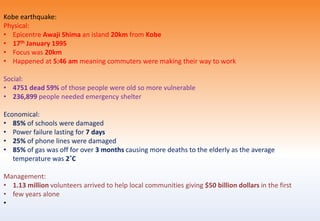
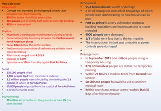
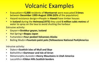
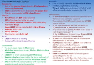
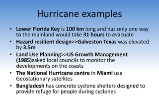
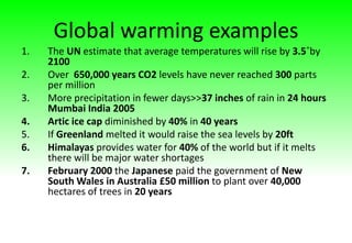
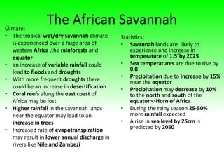
Tectonic
Examples
• Island Arc>>Aleutian Islands
• Ocean trenches>>Marianna Trench
• Fold Mountains>>The Andes (South America)
• Submarine Volcanoes>>Surtsey Island (Iceland)
• Continental Hotspot>>Yellow Stone National
Park(North America)
• Shield Volcanoes>>Hawaii
• Sea Floor spreading>>Mid Atlantic Ridge(Eurasian
plate and North American Plate )
Plate Boundaries
• Conservative>>San Andreas Fault (North
American and Pacific Plate)
• Constructive>>Iceland(North American and
Eurasian)
• Destructive>>South American and
Nazca Plates
• Collision>>India(Eurasian and Indianna plate)
Examples of Earthquake Impacts
• Unconsolidated sediments>>Armenian
(1988)earthquake 95% of the buildings
were destroyed in Leninakan
• Landslides>> 1964 Alaskan Earthquake
had $1.26 billion worth of damage
• Aftershock>>Indonesian Earthquake
(2004) 9.3 magnitude had an aftershock
of 6.1
Earthquake prediction examples
• Park Field centre (America) had
monitoring equipment to watch for any
tell tale earthquake signs
• Quake Finder is a device that measures
electromagnetic changes in the ground to
sense if the earthquake is coming
Northridge Case Study
Background:
• Los Angeles sustains $1.07 billion damage per
year
• MEDC
Physical aspects:
• The Pacific Plate moves past the North
American Plate at 45mm
• Happened along the San Andreas Fault
• Conservative plate boundary
• Depth of the focus 17.5 km
• Occurred along a blind fault
• Magnitude of 6.7 with aftershocks of 5.9 and
5.6
• 17th January 1994
Social:
• 57 people were killed
• 11 hospitals suffered structural damage
• 9,000 people were injured
• 20,000 people were displaced from their home
Environmental
• 50 fires broke out in the San Fernando Valley
• 11,000 landslides were triggered
• Landslides blocked roads and damaged water
lines
Economical:
• 12,500 buildings suffered
• Roads were damaged up to 32km from the epicentre
• 11 hospitals suffered structural damage
• Three storeys of the Northridge Meadow apartment building
collapsed
• 170 bridges were damaged
• 2,500 multi-story car parks were damaged 3km from epicentre
• 700,000 applications for financial help were made to FEMA
• The football scoreboard at Anakeim Stadium collapsed over
several 100s of seats
• Olive View hospital withstood the earthquake after building work
took place after the ?1974? earthquake
• 82,000 homes and businesses were without electricity
• 50,000 without water
• It cost the US $20 billion dollars to recover the damage caused
• Only 20% of the businesses in Northridge carried earthquake
insurance
• Santa Monica freeway and Golden state freeway were both
damaged
•
Management:
• Larse is mapping out all hidden fault lines to allow buildings to not
be built along them
• Larse uses sound waves travelling near the earth’s surface to
detect fault lines
• The ARC(American Red Cross) sheltered 22,000 people
• The ARC spent $36 million looking after people after the
earthquake
Japanese earthquake
Physical:
• 9 on the Richter scale
• Epicentre of the earthquake was 130km off the
coast of Japan
• Northern Japan sits on the Eurasian plate and the
Pacific plate. The pacific plate moves westwards
sinking underneath the Eurasian
• The subduction caused the ocean to move by 40 M
creating the massive waves
• Highest wave was 30 m
• 90/400 nuclear reactors are on plate boundaries
Social:
• 15,400 people died
• Half a million people lived in shelters
Economical:
• Damage was estimated at $120 billion -$230 billion
>>2.5-4.0% of Japans GDP
• Factories were damaged by the disaster meaning
there a was a direct decrease in supply exports
• The draw back from nuclear power means an
increase dependence on fossil fuels
• Increased government debt 225% of annual GDP
Environmental:
• A dam in the North East of Fukishima
burst its banks causing water to
sweep away many homes
• 400 millisieverts hour was the
radiation level emitted by the nuclear
reactor
Management:
• Japan’s automated system managed
to shut down the reactors
• They get mobile alerts for various
tectonic activity
• At Mikato they had a 10m high sea
wall
• 70,000 people were forced to migrate
35km away
Gujarat India earthquake
Physical:
• 26th January 2001
• 7.9 on the Richter scale
• 17 km focus
Social:
• Death toll 20,000
• 160,000 people seriously injured
Management:
• 5,000 troops were deployed and 40 aircraft military to help clear rubble
• A building regulation set up in 1998 to prepare was ignored
Economical:
• 800,000 buildings suffered damage
• Bhuj Bhachau Anja lost 90% of the buildings
• Cost of the earthquake is around $4-5 billion
•
Sichuan Earthquake China
Physical:
• The earthquake happened on the 12 May
2008
• 7.9 magnitude
• Shaking lasted 5 minutes
• Shallow focus of 19 km
• Several aftershocks exceeding 6.0
• 315 million tonnes of water could have
weakened the fault increasing stresses
Social:
• Over 5 million homeless
• 70,000 death toll
• Landslides caused 1,000 deaths
• Heavy rainfall triggered a mudflow killing 158
rescue people
• Environmental:
• A train in the Gansa area spilt 500 tonnes of
gasoline the fires it produced took 40 hours
to put out
•
Economical:
• 80% of houses collapsed
• $150 billion estimated cost of the damage
• 5.4 million buildings collapsed
Management:
• Authorities had to evacuate 250,000 people for
fear of them drowning as a result of the water
escaping from damns
• Earthquake building code set down in 1976 is
mandatory in China however many have ignored
it
• 1.3 billion dollars used to reconstruct 2,600
schools
• 169 new hospitals to be built and 860,000 new
city apartments will be built
Sichuan extra 2013
• 90% of houses damaged as building regulations still
ignored
• 7 on the richter scale
• Around 200 dead(figure debatable)
• "100%" of houses in the 9 towns and townships and in
the county seat were damaged (Lushan area)
• However, around 60 giant pandas in the Wolong
National Nature Reserve in Ya'an, were left unharmed
by the devastating earthquake. (sorry this just made
me laugh as it was on a genuine news report)
Christ Church New Zealand and aftershock
Physical:
• The earthquake struck on 4th September 2010
• 7.1 on the Richter scale
• 22nd February 2011 and after shock struck Christ
Church registering 6.3 on the Richter scale
• The aftershock was 5km in depth of focus
• It happened at12:51pm causing more deaths
Social:
• Nobody died in the first instance
• 181 people died as a result of the aftershock
Environmental:
• Canterbury plains are made up of alluvial sediments
have a large water storage units so the earthquake
caused significant liquefaction
Economical:
• $16 billion New Zealand dollars’ worth of damage
• Six storey Canterbury television building collapsed
• 100,000 damaged buildings
Management:
• Geonet detects and monitors
earthquakes can provide
emergency services with info within
a few minutes of an earthquake
• Earthquake commission funds
Geonet it also funds programs for
people Quakesafe their homes
• The AMI stadium has been
reinforced by 10m stone columns
which can stop liquefaction
Boxing day Tsunami 2004:
Physical:
• The earthquake occurred under the Indian
ocean
• Measured 8.9 on the richter scale
• Focus 10 km
• The epicentre was 256km from Indonesia
• The indian plate was pushed under the
Eurasian plate along a 1040km fault line
Social:
• 5,395 dead in Thailand
• 120,000 people have been effected by damage
caused to the fishing industry
• In India 9,000 people died
• 12,500 people were displaced by the flooding
• Environmental:
• 20/199 of the Maldive islands were destroyed
Economical:
In thailand
• The hotels only managed to fill 10% of
their rooms out 35,000
• International passenger arrivals in
Phuket airport were reduced by 88%
• Effected tourist areas stood to lose
about 5 million tourists
• 1 in 5 hotels had to close
• In Somalia 1000 homes were destroyed
• 240,000 fishing boats were lost
Kobe earthquake:
Physical:
• Epicentre Awaji Shima an island 20km from Kobe
• 17th January 1995
• Focus was 20km
• Happened at 5:46 am meaning commuters were making their way to work
Social:
• 4751 dead 59% of those people were old so more vulnerable
• 236,899 people needed emergency shelter
Economical:
• 85% of schools were damaged
• Power failure lasting for 7 days
• 25% of phone lines were damaged
• 85% of gas was off for over 3 months causing more deaths to the elderly as the average
temperature was 2˚C
Management:
• 1.13 million volunteers arrived to help local communities giving $50 billion dollars in the first
• few years alone
•
Haiti Case study
Background:
• Damage was increased by widespread poverty ,bad
infrastructure ,food insecurity
• 80% live below the official poverty live
• 86% people live in poorly built slums or concrete buildings
• 80% are unemployed
•
Physical:
• Magnitude 7 earthquake>>sedimentary shaking of rocks
• Conservative plate boundary between the Caribbean and
north American plates
• Focus 10km below the earth’s surface
• Predominant composition of sedimentary which is more
prone to shaking
• Aftershocks ranged from 4.5-5.9
• Slippage of 1.8m
• Epicentre was 15km from the capitol Port Au Prince
Social
• 230,000 people killed
• 3,889 people died from the cholera endemic
• 3.5 million people were affected by the earthquake 2.8
million of which in Port Au Prince
• 60,000 people migrated from the capitol of Port Au Prince
• ¼ of civil servants dead
•
Environmental
• 20 million m³ of rubble on the ground less than 5% has
been cleared
Economical
• $5.8 billion dollars’ worth of damage
• A lot of corruption and lack of knowledge of which
people own land meaning no new houses can be
built
• Port au prince is a very vulnerable capitol as
building regulations are inadequate and it is over
crowded
• 4000 schools were damaged
• 1/5 of jobs were lost due to the earthquake
• The international airport was unusable as power
controls were damaged
•
Management
• In September 2011 one million people living in
temporary housing
• 87% of homeless people are still in the temporary
housing
• Within 24 hours a medical team from Iceland had
landed
• 50 Chinese people followed to act as another
medical team
• British search and rescue teams reached Haiti 5
days after the earthquake
Volcanic Examples
• Evacuation>>5,000 residents of Montserrat were evacuated 3 times
between December 1995-August 1996 (63% of the population)
• Hazard resistance design>>People in Hawaii have timber houses
• In Iceland during the Heimaey(1973) they used 6 million cubic metres of
water to spray on the lava to avoid shutting the harbour
Extrusive activity:
• Geyser>>Strokkur geyser, Iceland
• Hot Spring>>Beppu Japan
• Fumaroles>>Four peaked Volcanoes Alaska
• Boiling Muds>>Fountain paint pots (Yellowstone National Park)America
Intrusive activity:
• Dykes>>Scottish isles of Mull and Skye
• Batholiths>>Dartmoor and Isle of Arran
• Metamorphic Aureole>>Henry Mountains in Utah America
• Laccoliths>>Eildon Hills Scottish borders
Montserrat volcano
Background:
• LEDC
• Part of the British Colony
• Caribbean tourist hotspot
Physical:
• Early activity like ash emissions, steam explosions and numerous
earthquakes
• The steam and ash reached heights of 2500m
• March 1996 huge ash cloud and pyroclastic flow happened
• The climax occurred on the 25th June 1996 4.5 million m³ of ash
erupted from the volcano
• 11th February 2009 40 million m³ of rubble from the north eastern
portion of the lava dome collapsed
Social:
• A lot of post-traumatic stress disorder
• The pyroclastic flow killed 19 people
• Between 1995-1999 the population decreased from 10,000 -3,000
growing back to 5,000 after 2006
• Silicosis a lung disease effected a lot of people
Environmental:
• Only 40km² out of 100km² was safe to live on
• The southern island was completely destroyed
• The eruption in 1995 effected 63km around the island
• 1/3 of the tropical rainforests were damaged
• The soil was enriched with volcanic ash
• Feral farm animals like cows have caused problems in the exclusions
zones destroying native species
Economical
• Plymouth was eventually buried in over 10m of ash and
mud and the airport and docking facilities were destroyed
• The construction a new airport cost £11 million known as
Gerald’s 2005
• 1,500 people flocked to the island looking for jobs as they
were construction workers
• Enrolment in all schools dropped from 2,672-620 between
1996-1998
• 300 fulltime farmers lost their land as a result of the
explosions
• Montserrat is now dependant on food imports
• In 1997 annual tourists were at 4,000 when they should
have been 15,000
• 400 students left the medical school (American University
of the Caribbean)
• Money has also been invested into attracting new sets of
tourists to the Caribbean like families or travellers not just
newlyweds or nearly deads
Management
• They set up temporary shelters to the North
• 7,000/01,000 inhabitants left for the UK or Antigua
• A new observatory centre has been set up in Montserrat
• UK government spent £100 million assisting migration
• Stations with infra-red sensors which detect air pressure
which are set of as a result of eruptions have been set up
• 2004 a 5 million grant from the UK was given by a
organisation called international development to build more
hotels to boost the tourist industry again
• 2,000 new homes built as most of the population is still in
temporary accommodation
Mount Etna
Background:
• Europe’s largest volcano
• The mountain was 2368m high
• One of the most active volcanoes in the world
• Calderas surrounds Etna
• Collision of the African and Eurasian >continental plates
Physical:
• Eruption 14th December 1991
Environmental:
• Effusive lava flows lasted 473 days
• Lava destroyed the springs which provided the water supply for Zafferana
Economical:
• Insurance claims ran into millions
• Vineyards and chestnuts orchards were destroyed
• Only one house was destroyed
• Tourist industry boomed once the volcano was safe to visit
• 25% of the population lived on the slopes of Mount Etna meaning they had to move
• Ski station at Piano Provenzana was destroyed by lava flows
Management:
• They constricted earth barriers perpendicular to the flow direction diverting 30% of the lava flow they did by using
concrete blocks to halt lava flow and then managed to dig a diversion channel
• They sourced explosives to disrupt the lava flows away from Zafferana
• The earth barrier built in 1992 was 400m long and 20m high managed to contain the lava for a month
• US Marines operated the explosives
Mount Pinatubo
Physical:
• Typhoons created Lahars and flooding
• 1991
• Massive tropical storm of Yunya caused the
lahars
Economical:
• 1,000,000+ farm animals died, many
through starvation.
• 650,000 workers lost their jobs.
Social:
• Disease spread quickly, Malaria, Chicken Pox
and diarrhoea. Also heavy treatment for
respiratory and stomach disorders.
• 700 deaths: 6 as a direct result, 600+ from
disease and 70 from drowning in lahars.
94% of the deaths were from the Aeta tribe.
There were unaccustomed to being
surrounded by modern day diseases and
food. It was mainly children that died as a
result of disease (Eg. Measles)
Environmental:
• Ash cloud and sulphur compounds shielded
the Earth from the sun’s rays; the global
temperature was reduced by 0.5ͦc.
Management:
• Some Indigenous Aeta tribe displaced. 58,000
people evacuated.
• Philippine Institute of volcanology and seismology
(PHIVOLCS) was alerted when small steam eruptions
were seen. Also USGS (United States Geological
Survey) were called in to monitor the eruption and
attempt to predict the activities.
• 7 seismic stations set up surrounding the volcano by
May. (They were linked back to the Pinatubo
Volcano Observatory (PVO) which had been set up
on Clark Air Base).
• SOշ levels monitored every day. Closer to eruption,
up to 5000 tonnes were emitted every day.
Measured by a COSEC machine.
• Deposit samples taken from previous eruptions. Tree
remnants found showing only a previous 4/5
eruption in 2000 years. (Few eruptions usually mean
they are more violent when they do happen).
• Alert Level 1 Small scale evacuations, villages
within 10km of summit were evacuated. Expensive
equipment removed from Clark Air Base.
• Alert Level 3 Predicted within 24 hours. 120,000
people evacuated from a 10 mile radius. By 10th
June, nearly all of Clark Air Base was evacuated.
Evacuation radius now extended 30km.
Nyiragongo
Background:
• Located in the Virunga mountains within Democratic
Republic of Congo.
• Associated with the African rift valley.
• 20km north Goma, just West of the Rwandan border.
• 2002
Physical:
• Beneath Nyiragongo, the African plate is splitting apart
creating a rift valley.
• Very fluid alkaline magma rises up through the gap
created by the rifting.
• The magma that erupts from Nyiragongo has a low silica
content and can flow at speeds of up to 60mph.
Social:
• 120,000 homeless
• 147 people were killed
• Eye irritation, respiratory problems and diseases caused
by contaminated water and fumes
• Looting from abandoned homes and petrol store which
exploded, killing looters.
Environmental:
• 13km fissure opened in the south of the volcano
• Lake Kivu, a major source of drinking water, was polluted
by sulphuric lava.
• High temperatures caused fears of toxic gases releasing
from the lake bed.
Economical:
• From this lava formed a 600m wide, 2m deep
stream that reached Goma in a few hours, causing
fires
• This destroyed 4500 (15%) of Goma’s buildings
• Infrastructure, including communications and
transport links, was destroyed
• Goma airport was partially covered in lava
• Unemployment due to destroyed businesses
Management:
• UN bring in humanitarian aid 2 days after eruption.
• Rations included high energy food e.g. biscuits.
• UN also set up refugee camps at a cost of $15
million (Repair cost was even higher)
• Medical attention required – treatments for smoke
and fume inhalation.
• Because advanced warning systems from wealthier
countries meant the population was warned in
advance.
• The city of Goma was damaged, but was far
enough from Nyiragongo to allow evacuation.
• If the eruption had happened 100 years ago,
before organisations like the USGS, the death toll
would have been much higher.
Puyehue-Cordón Caulle
Background:
• Puyehue volcano has a 2.4 km wide summit
caldera
• The Cordón Caulle geothermal area has a 6
by 13 km wide depression and is the largest
active geothermal area in the Andes
Physical:
• Eruption began on the 4th of June, 2011.
• It was caused by the Cordon Caulle, not
Puyehue
• The ash cloud reached 12km high
• 230 earthquake tremors occurred in one
hour
•
Social:
• 3,500 people were evacuated
Environmental:
• Sulphur and other gases were emitted
• An estimated one hundred million tons of
ash, sand and pumice were ejected
• The eruption produced lightning and strong
storms and some power cuts
• The temperature of the Nilahue River rose to
45 °C and killed an estimated 4.5 million fish
• Economical:
• Bariloche, Buenos Aires, Neuquén and Melbourne
airports were closed due to ash
• 4.5 million fish dead had a big impact on the fishing
economy
• The cattle economy was also damaged
• The ash cloud led Argentina to declare a state of
emergency for farmers as the eruption continued to
effect the 2 million sheep that graze in Chubut
• Macquarie Equities placed the cost of disruptions to
airlines at $21 million for Qantas and $11 million for
Virgin Australia
Management:
• The ONEMI put Chile on “red alert
• Evacuees were moved into temporary shelters but by
the 19th of June the ONEMI decided that all 4,200
evacuees could return home, as the scale of the
eruption continued to decrease
• The Argentinian government supplied $2.41 billion
dollars to 1,400 farmers and businesses in the area
affected and planned to spend $7 million on the
cleanup operation
• 3,500 people were evacuated
Nevado del Ruiz, Colombia (5)
Social:
• Lahars killed 18,000 people in the town of Chinchina and 22,000 people in
Armero (nearly 70% of the population of Armero)
• Most of the housing was destroyed and 8000 people were made homeless
Economical:
• Livestock and crops were destroyed - over 3400 hectares of agricultural land was
lost
• 60% of the regions livestock and 30% of sorghum’s rice crops were destroyed
• Most roads, bridges, telephone lines and power supplies were destroyed and the
whole region was isolated
• The cost of the eruption to the economy of Colombia was estimated at US$7.7
billion (about 20% of GDP that year
Management:
• The hazards had already been mapped by scientists who had started gathering
data since early 1985 and the hazard map was due to be presented the day after
the disaster
• In 1986 scienetists said people could return home however two days later there
was a mud flow in Armero
World Cities and Urbanisation
Examples of Types of Cities
• Megacities:
Delhi(India),Dhaka(Bangladesh), Lagos(Nigeria)
• Metacities: Tokyo(Japan)
World Cities:London(England),Chicago(America)
Mumbai:
Back ground Problems:
• 14,350,000 population
• Indian Financial Centre and the centre of
Bollywood
• Population due to read 26 million by 2025
Growth problems facing Mumbai
• New migrants are coming in everyday wanting a
share of the new wealth
• The port has enable India to become a exporter
• Most of the migrants are uneducated and
therefore are not needed in a modern city
• It has caused urban sprawl (cheap and poorly
built)
• Massive overcrowding
• Development of squatter settlements like
Dharavi
• The Mumbai Suburban Railway, created in 1853,
links Mumbai to rest of India which is good for
business and trade making it the best way of
transport in Mumbai (7million/year). Means
more people are being able to come to the area
causing a shortage in houses.
Dharavi:
• It is the biggest slum in Asia
• Home to more than 600,000 people spread
over 175 hectares
Economical:
• Industries are estimated to make
$700million dollars worth per year
• There are 4,500 industrial units in Dharavi
producing leather,clothes,jewellry,food and
soap
• Huge recycling industry employing 250,000
people
• Less than 10% is legal buisiness
Problems:
• Dharavi restricts the growth of Mumbai
• Dharavi sits south of the Mithi River not far
from Bandra Kurla Complex>Major
buisiness hub
• Huge hubs or typhoid and cholera
Mumbai continued:
SRA Development:
• The slum dwellers whose names was
on the voters list of 1995 will be
eligible for rehabilitation
• Each family will be allotted 225
square foot free of cost
• The residents will have to pay for
their own water and electricity
• They gain wider
roads,electricity,ample water,medical
centres,and playgrounds/schools
• Dharavi will be divided into 10
sectors a developer responsible for
each one
• Buildings will be 7 storeys high
• The non polluting businesses in
Dharavi will be kept they will also be
provided with modern technology
2004 Dharavi plan:
• 1 million low cost homes will be built
• Slum populations will fall to 10-12%
instead of 60%
• There will be 325 open green spaces
• 300 public toilets
• The land that Dharavi is built on is
worth $10 billion dollars as it has a
prime location
• For every sqft of new affordable
housing built the developers will be
allowed 30% commercial development
e.g for shops
• By 2013 it is supposed to be a world
class location
Examples of city areas
• 1960-1981 1.6 million jobs were lost from
the inner city areas
• 1994 the inner cites had an unemployment
rate of 50% higher than the rest of the
country
• New Town>>Telford (west midlands)
• Expanded Towns>>Bromsgrove and
Droitwich
Suburbanisation: (7)
Why people moved:
• Home to TV and film industry, so workers have
higher paid jobs
• Higher disposable incomes means that car
ownership increases so commute to work
• Other services locate here as people can afford
to use the service
• Higher incomes means people want larger
houses with gardens and garages for family
• Increased I.T technology allows people to work
from home
• Only 7.8% in Beverly Hills do not own cars
• Certain races forced out due to migration of
another race causes suburbanisation
• E.g. Compton is a poorer district where 28% do
not own cars, populated with Hispanics.
• When the Hispanic people moved into
Compton, the previous race, of white ethnic
background moved out. Causes LA to spread
further out = Urban sprawl
•
• Case Study: Los Angeles, USA:
• Located south California, West USA
• 3.8 million people in 2006
• Young unskilled workers attracted to the
area due to Hollywood and Beverly Hills,
film and TV industry
• Effects: the movement of people and
excessive amounts of suburbanisation
causes urban sprawl.
• Problems:
• More congestion of cars travelling inner city
• Pollution :air, noise, visual
• Higher crime rates in poorer districts e.g.
Compton
• Shortage of houses
• Urban sprawl, loss of rural areas, country
side and villages. Social segregation, all
wealthy in suburbs and poor are trapped.
Suburbanisation facts
• In 2008 it was the plan to build 490,000 new
homes in the west midlands
Longbridge (brownfield) (4)
• Birmingham City Council and Bromsgrove
District Council
• a regional transportation interchange with
1,000 park and ride spaces, and the creation of
at least 10,000 jobs.
• Birmingham CC lead on the project, and
Worcestershire CC and Bromsgrove DC have
been involved
• Huge plot - 468 acres
• £1 billion Longbridge scheme is one of the
largest regeneration projects in the West
Midlands
• 2,000 new homes
Brecon View housing – Gornal
(greenfield):
• There are four primary schools
and four secondary schools
located nearby
• Sainsbury's Supermarket less
than a mile away but Dudley
town centre, located less than
two miles away, has high street
stores and boutiques.
• Tandon, Greens and Lower
Gornal Medical Centres close
by
Case Study: Notting Hill Gentrification
London borough of Kensington and Chelsea
West London
• During the Victorian times the area was rough and full of working class people
• In the 1950’s it became a slum area of inner city deprivation
• 1958 was the race riots between Afro Caribbean and the ‘Teddy Boys’
• 1959 The Notting Hill Carnival was started by Claudia Jones as a response to the riots and the state
of race relations in Britain at the time.
• Area is famous for Portobello market and carnival
What?
• Past 30 years it undergone gentrification e.g. primrose Hill
• Property prices have rose to £4million
• Secluded communal gardens = more desirable for wealthy families with children
• ‘Notting Hill’ movie helped popularise the area although gentrification had already happened
• Now has 21 screen cinema opened in 2001
• Many services such as boutiques, restaurants e.g. Feng sushi, wine bars etc.
Counter Urbanisation:
Copmanthorpe:
• Few km south west of York
• Become commuter villages
• The A64 provides a fast link between York and Leeds
Impacts:
• The population increased from 1,261 (1961)-4,008(1991)
• 50% of the population have two or more cars
• And 32% of the population is between 35-65
• Gained a hair dressers, cooperative, and a fish and chip shop
• Also has an improved toddler play group
Bayston Hill (48km from Shrewsbury):
• Has a population of 5,500 in 2007
• In 1971 1520 new homes were built
• Before 1971 the population was 2000 it grew to
5345
• The Meole Brace retail park was built in the
1980s to attract new shoppers
• 97% of people still use local shops
Swardeston (7km south west of Norwich)
• Has commuter services into Norwich(buses
and park and ride)
• Many of the new homes are very expensive
7/9 of the houses are above the UK average
of 168,000
• The village shop closed down as a result of a
Tesco extra opening 5km away
Examples or re-urbanisation
projects
• English Partnerships>>Milton Keynes
• Local Enterprise
partnerships>>Northampton,Hereford
• UDCs>>London Thames Gateway
• Gentrification>>Islington ,Battersea
(London)
UDC Thames Gateway Case Study:
• Starts on canary wharf>1988
• 97 acres of pleasant working environment
(open spaces, parks)
• 14.1 million sqft of office and retail space
• 90,000 people work in canary wharf
• Businesses are attracted to it as it is close to
HSBC, and Barclays which are international
companies
• Close to London City Airport
• Stratford City has gained 35,000 new jobs out
of the hoped 46,000
• £1.5billion investment by DP World(Largest
Marine Terminal Operator)
Re-urbanisation Projects: Flagship project Cardiff Bay:
• Ended in March 2000
• 1250 new apartments were built
• 5 star luxury hotel was built in
2000(St David’s)
• Welsh Millennium Centre(national
opera centre)
• 5780 new houses were built
• 31,000 new jobs
• £1.8 billion private finance was
invested
• £700 million international sport
village
Aims:
• To reunite Cardiff with it’s
waterfront
• To build a superb living and
working environment
• Create a wide range of jobs
Re-Urbanisation continued
NDC Aston Pride :
• Government funded operating
from 2001-2011
• Designed to improve the lives of
17,300 residents
• £8m investment in a brand new
health care with longer opening
hours
• Key stage 2 performance improved
from 49.1%(2002) of students
getting through secondary school
to 73%(2010)
• Key stage 4 performance went
from 34.2%(2002)-83% (2010)
• 2,500 computers have been
introduced into residents homes
• 1328 local residents found
employment
• The areas has reached the 3rd safest in
the UK and has a burglar rate of 265
per 1000
• Local area is now a much cleaner place
as the number of residents reporting a
problem went from 56%-32%
• £470,000 community chest project
supported 4,100 residents,440
volunteers in new projects
• The project^ was supported by
405/500 of the local businesses in the
Aston Pride area
• Over 8,500 have received support in
the health service
• Over 3,000 people have received
support for domestic
abuse,welfare,materniry or healthy
eating programmes
Re-Urbanisation Continued Continued
RDAs(Regional Development Agency)
West Midlands:
• 150,000 new businesses were assisted
to help improve performance
• 10,000 businesses set up
• 1,200 hectares of brownfield site was
built on
• New Street Station (Birmingham) had
£100million invested in it creating
10,000 new jobs
• 392 inward investment projects by
international companies managing to
safe guard 12,161 jobs
NDCs
• £5.8 billion of funding poured
into supporting 1,000 schemes
across england
• The developed areas showed
improvements in 32 out of 36 of
the core indicators
Out of town Shopping Centre Retail
Trafford Centre Manchester:
• 5.5million people live 45 minutes away from it this is because people can travel from
Liverpool in the west and lees and Stoke on Trent to the north
• In 2005 29.4 million people visited the centre with a peak during December
• It has a 16,000 seat food court
• Has a bowling alley and an ODEON cinema
• UK's busiest cinema, attracting more than 28,500 visitors each week
• It has a large furniture department created in 2006
• It is very accessible as it is close to m6,m61,m62
• 11,000 free car parking spaces
• Also a bus station which sees 120 buses an hour
• It is made up of 4 floors and a leisure village
• 280 stores/services
• total space for:,Retail: 185,000 m2,Leisure: 16,258m2,Dining: 13,935m2
• Construction took 27 months costing approximately £600 million, approximately £750M as
of 2012
• 35 million visitors annually
Effects of the CBD:
• Leads to discount and charity shops in CBD
In town Shopping Centres
Bullring(Birmingham) :
• In 2004 on it’s first year it had 36.5 million
visitors
• 125,300 square metres or retail space
• 4 floors
• More than 160 stores and 25 restaurants
• 37 million visitors are attracted to the
Bullring each year
• Has attracted shops like Zara, Next,Top
Shop
• The 15,000 aluminium discs on the exterior
make for a tourist spot
• Open 11-5 on Sundays
• 350,000 flocked to the Bullring boxing day
2012 for the sales
• It has 1 of the 4 Selfridges stores in the UK
• Attracts customers from New York
• 4th largest Debenhams and the only
Forever 21 in Europe
Touchwood ( Solihull):
• Created over 2,000 retail jobs
• Close partnerships have been
developed with John Lewis and the
Job Centre
• 20 restaurants and a Cine World
• 265,000 sqft John Lewis
department store
• There are 104 stores and services
Other small points
• establishing theme areas, such as
the gay area in Manchester and
• the cultural quarters in Sheffield
and Stoke
• developing flagship attractions, for
example the photographic museum
in Bradford
• promoting street entertainment,
such as at Covent Garden in London
Sustainability Curitiba Brazil and Mumbai
• South West of Sao Paulo
• Jamie Lerner was elected mayor in 1971
and wanted it to become ‘a city of people
not cars’
• It has 5 structural arteries that run east to
west and are encouraged to have
developed Areas along them
• This ^ diverts traffic from the city centre
• In 1970 there was 0.5 km² of green space
per person now there is 5km²
• There are 26 parks in the city and 1.5
million trees
• There are 40 special features for feeding
street children
Transport:
• There is a bus and sub way system
• The transport is cheap and reliable as
75% of commuters us them
• 25% less congestion and 30% lower fuel
consumption
• The buses have three compartments each
bus can hold 270 people
• 10% of your wage goes to transport
The green swap programme:
• Citizens are asked to sort rubbish into organic
and inorganic the rubbish is then collected
and taken to plants
• The plants employ recovering Alcoholics and
Homeless people
• Recovered materials are sold to local
industries
• The programme is voluntary and 70% of
households are involved
• Highest recycling rate 70%
• At collection point in Favelas dwellers receive
in exchange for their rubbish basic food bags
from farmers of the state
Mumbai recycling Industry:
• Dharavi turns round waste from 19 million residents
• They recycle plastic, ball point pens, vats of waste of
soap
• 15,000 single room factories processing 400 tins a
day
• Dharavi’s recycling industry employs 250,000 people
• 805 of Mumbai’s plastic waste is recycled
• The plastic recycling industry employs 10,000 people
alone
London Congestion Charge:
• London has a congestion charge to raise funds for London’s
transport system
• £8 charge each day and £10 for a vehicle travelling 7am-6pm
Monday to Friday
• Fine of £60-£180 for non-payment
• Congestion was costing £2million a week for business
• It has increased bus usage
• 26% reduction in congestion since 2006
• £137 million raised in 2007-2008 spent to improve London’s
transport system
• Reduction in road accidents by 40%-70%
Weather and Climate
Examples of Urban heat Island
• Precipitation>>5-15% more in urban areas
• Temperature>>can be up to 5 degrees
warmer in urban areas
• Thunderstorms>>25% greater chance of
thunder storms
Kuching Indonesia:
• It has nearly 1 million inhabitants most of the city is 27m
above sea level
Weather:
• it has daily temperatures in the shade ranging from 25
degrees in the morning and 33 in the afternoon
• It is the wettest city in the world with an annual rain fall of
4,000mm
• Ambient day temperatures can range from 28-40 degrees
• Evaporation rates are high and lead to violent storms
• The city's tarmac and buildings plus the heat from the outlets
air conditioning units can lead to torrential rainfall in the
CBD whilst the suburbs 2-10km away stay dry
Urban heat island Case Study
Pollution control examples
• Land use planning>>Curitiba (Brazil) separated zones
for heavy industry and housing
• Acts>>in 1960s the USA introduced a series of clean air
acts and particulate emissions fell by 80%
• Bad pollution>>Britain suffered 4,000 deaths in 1952
from high incidence of coal particles in the air
• Pollution reduction policies>>1956 (London)
introduced smoke free zones
• In Athens they created a traffic free zone 2km²
•
• Hurricane Sandy (2012)
• Physical:
• Category 3 hurricane
• Largest Atlantic hurricane on record
• 1,100 miles in diameter
• On October 25, Sandy hit Cuba as a Category 3
hurricane
• then weakened to a Category 1 hurricane. Early on
October 26, Sandy moved through the Bahamas
Economic
• Damage was $75 billion
• In Jamaica, winds left 70% of residents without
electricity, blew roofs off buildings
• $100 million dollars’ worth of damage in Jamaica
• Cuba sustained $2 billion dollars’ worth of damage
Environmental
• As a result of the flooding Haiti experience serious food
shortages
• In Cuba, there was extensive coastal flooding and wind
damage inland, destroying some 15,000 homes
• The remnants of Sandy produced high winds along
Lake Huron and Georgian Bay, where gusts were
measured at (63 mph). A (72 mph) gust was measured
on top of the Bluewater Bridge
Social
• 285 people were killed
• Killed one person in Jamaica
• In Haiti, Sandy's outer bands brought flooding that
killed at least 54
• 200,000 homeless in Haiti
• 11 people died in Cuba
Management:
• Disney–ABC Television Group held a "Day of
Giving" on Monday, November 5, raising $17
million on their television stations for the
American Red Cross
• The United Nations and World Food
Programme said they will send humanitarian
aid to at least 500,000 people in Santiago de
Cuba
• NBC raised $23 million during their Hurricane
Sandy: Coming Together telethon.
• News Corporation donated $1 million to relief
efforts in the New York metropolitan area.
Cyclone Orissa, North East India,
Physical:
• 29th October 1999
• Water reached 30km inland and the
heavy rains continued for 36 hours
• 270 km/hr. wind speeds. Storm Surge
in Bay of Bengal, sea level rose by 9m.
• 10 districts in Orissa were affected
Social:
• People ignored evacuation warnings,
10,000 people died. However with
disease and injury the total was much
higher than this.
Economical:
• 1,800,000 hectares of agricultural land
were damaged.
• Several fishing villages on the coast
were washed away.
• 1/3 of the state’s 2 million houses were
damaged and only well-built buildings
remained.
•
Environmental:
• Food shortages and lack of clean water. 40,000
wells were affected (Contaminated and broken).
• 1,800,000 hectares of agricultural land were
damaged.
Management
• Central Indian government allocated 96,000
tonnes of rice by March 2000. 50,000 tonnes of
wheat was supplied to the state government for
conversion to flour.
• 9000 cases of diarrhoea and over 160,000
ailments Ministry of health supplied medicines.
• Normal water supply has been restored in all the
urban areas by early 2000.
• Mid 2000- power restoration varied between 4%
and 85%. It was proving difficult because of
massive damage to transmission lines.
• The United Nations prepared a long term action
plan to undertake various measure in Orissa. These
included programmes to develop several sectors
including forestry, health and the environment.
Hurricane Mitch
(1998)
Physical:
• winds reaching 180 mph.
• Category 5 Hurricane.
Environmental:
• Heavy rainfall, some areas
received as much as 18 inches in
one day.
• Rivers overflowed causing
flooding.
Social:
• 19,325 deaths
• 2.7 million people were left
homeless
• The contaminated flood water
resulted in an increased number
of malaria and cholera cases, 34
people died of cholera out of the
2328 people who caught it.
Economical:
• Farm land was destroyed which affected 29% of Honduras’
arable land.
• 70% of Honduras’ crops were destroyed by flooding.
• An estimated 50,000 cattle were also killed.
• 33,000 houses in Honduras alone were destroyed.
• 50,000 houses in Honduras were damaged.
• 25 small villages were thought to have been entirely
destroyed
Management:
• The hurricane was predicted through the use of satellite
images from space while it was still at sea.
• Predictions of heavy rainfall and flooding were also made
• Countries from around the world donated a total of $6.3
billion (1998 USD)
• US administration donated only $2 million which was a
shock to many; this was later increased to $70 million. The
money was used in the long run to help the economy
recover and so that houses could be rebuilt to withstand
other hurricanes.
Cyclone nargis
Background:
• Since 1962 the country has been ruled by a
military junta with poor human right records they
have a refusal to accept the scale of the problem
and a reluctance to accept outside aid
Physical:
• The tropical system developed from a low
pressure system in the Bay of Bengal
• Winds reached 215 km
• Storm surge of 7.6m
Social:
• 2 million people were left with very little food
and water sources were contaminated by sewage,
bodies and animal carcasses
• Death toll 140,000
• 5 million people made homeless
• 75% of hospitals were badly damaged
• In Sri Lanka 3,000 families were displaced and
35,000 people were affected in all
• 70% of the population had no acess to clean
water
Environmental:
• Five coastal regions-Yangon, Ayeyarwardy,
Bago,Mon and Kayin were declared disaster zones
by the gouvernment
• 600mm of rain destroyed low lying rice paddies of
the Irrawaddy delta
Economic:
• The cost was estimated at $10 billion worth of damage
• 450,000 homes were destroyed
• 600,000 hectares of agricultural land was damaged
• 60% of farming implements were lost
• 95% of houses in low lying lands were washed away
• Cyclone destroyed 42% of Burma’s food supplies
Management:
• Association of South East Asian Nations intervened to
help facilitate exchanges of foreign aid into the country
• UN planes carrying emergency supplies were first
allowed into the country on Sunday after days of
negotiation and a consignment of high energy biscuits
from the World Food Programme
• The UN and red cross declared that some 2.5 million
people were in urgent need of assistance
• After international pressure the government eventually
allowed aid into the country towards on the 23rd of
May 2008
• Thailand sent US$100,000 in supplies including
thirty tonnes of medical supplies
• Indian weather stations warned the cyclone was
going to hit Burma 48 hours before it did
• French Navy ship carrying 1,500 tonnes of supplies
was refused entry as they thought it was a war ship
• Aid was sometimes seized by the military before it
reached the vulnerable people
Hurricane Katrina: (4),(1),(4),(3),(7)
Background:
• One of the poorest cities in America 1/3 of people are
below the poverty line
• 1927 hurricane the levees broke and 246 people died
• The city is surrounded by 350 miles of levees
Physical:
• New Orleans is 6-10ft below sea level
• 80% of the town lies below sea level
• The national hurricane centre had been monitoring
Katrina for 3 days
• August 2005 Katrina made landfall in New Orleans
• Category 5 hurricane
• Winds 280km/h
• Storm surges were 8.2m high
Social:
• 1,836 deaths due to flooding
• Rumours of looting and rape of homes
Environment:
• The storm surge made it 20km inland
• Mississippi levees broke in over 50 place 80%in the New
Orleans area
• 5,300km² of forest was destroyed in Mississippi
• Dauphin Island was breached by the storm and much of
the sand was transported into the Mississippi Sound
• 20% of marshlands were inundated with seawater so
breeding grounds for turtles were lost
Economic:
• Cost of damage estimated at $150 billion US dollars
• 3 million people had no electricity
• Thirty oil platforms were damaged in the Gulf and 9
refineries closed reducing production by 25%
Management:
• In 2004 Hurricane Pam simulation was tested out and
the levees were seen to be breached
• They predicted that 70% would migrate but 127,000
have no vehicles
• At the Superdome there was food and water for
15,000 people but 26,000 people turned up
• They would need to spend $20 billion on the levees to
protect against a category 5
• Of the 60,000 people stranded in new Orleans 33,500
people were rescued by the Coast Guard
• 58,000 of the national guard were activated to deal
with aftermaths of the storm
• 60,000 people moved over 1,200km away and were
still there one month after the storm
• FEMA paid for temporary hotel costs of 12,000
individuals but by July 2006 10,000 people still lived in
trailer parks
• FEMA under Micheal Brown’s orders delayed aid
agencies to go into the city
• Aid didn’t arrive until 3 days after the hurricane struck
meaning people were suffering from dehydration
Hurricane examples
• Lower Florida Key is 100 km long and has only one way
to the mainland would take 31 hours to evacuate
• Hazard resilient design>>Galveston Texas was elevated
by 3.5m
• Land Use Planning>>US Growth Management
(1985)asked local councils to monitor the
developments on the coasts
• The National Hurricane centre in Miami use
Geostationary satellites
• Bangladesh has concrete cyclone shelters designed to
provide refuge for people during cyclones
Global warming examples
1. The UN estimate that average temperatures will rise by 3.5˚by
2100
2. Over 650,000 years CO2 levels have never reached 300 parts
per million
3. More precipitation in fewer days>>37 inches of rain in 24 hours
Mumbai India 2005
4. Artic ice cap diminished by 40% in 40 years
5. If Greenland melted it would raise the sea levels by 20ft
6. Himalayas provides water for 40% of the world but if it melts
there will be major water shortages
7. February 2000 the Japanese paid the government of New
South Wales in Australia £50 million to plant over 40,000
hectares of trees in 20 years
The African Savannah
Statistics:
• Savannah lands are likely to
experience and increase in
temperature of 1.5˚by 2025
• Sea temperatures are due to rise by
0.8˚
• Precipitation due to increase by 15%
near the equator
• Precipitation may decrease by 10%
to the north and south of the
equator>>Horn of Africa
• During the rainy season 25-50%
more rainfall expected
• A rise in sea level by 25cm is
predicted by 2050
Climate:
• The tropical wet/dry savannah climate
is experienced over a huge area of
western Africa ,the rainforests and
equator
• an increase of variable rainfall could
lead to floods and droughts
• With more frequent droughts there
could be an increase in desertification
• Coral reefs along the east coast of
Africa may be lost
• Higher rainfall in the savannah lands
near the equator may lead to an
increase in trees
• Increased rate of evapotranspiration
may result in lower annual discharge in
rivers like Nile and Zambezi
International Protocols
• 1992 Earth Summit in Rio de janero the
developed countries agreed to try and reduce
emissions by 60%
• In 1997 in Kyoto (Japan) 100 governments
signed a climate change protocol
After the protocol:
• In July 2005 the G8 world leaders and
delegates from China,India,Brazil,south Africa
and Mexico attended a conference in Glengles
• The G8 countries are home to 13.5% of the
total world population and 39% of the
greenhouses emission per year
• UN Climate Change convention in Bali was
attended by 180 countries
• When the G8 leaders met in 2008 in Japan
they promised to halve their greenhouse gases
by 2050
The 1997 the protocol:
• Most governments agreed that by
2010 they should reduce their
emissions so they were less than
they were 1990
• The USA produces 15% more co2
than it did at the start of the 20th
century
• President Bush failed to carry out
the protocol as he said it was
flawed
• In 1996 the USA released 21% of
the global co2 even though it has
4% of the world population
National Responses
Climate Change Programme(2006):
• Building regulations tightened so
more insulation
• Vehicle exercise duty and company car
tax changed so finical benefits come
with low carbon cars
• The Carbon Trust was granted
£65million from the government to
help get small energy efficient
businesses off the ground
• In Scotland woodland creation
schemes were sponsored as they were
designed to reduce the amount of
nitrous oxide
Climate Change Bill(2008):
• By 2020 the country hopes to have 26%
reduction in CO2 emissions from the
1990 records
• By 2050 they hope to decrease it by 60%
• An annual review of targets by the
independent committee on climate
change
• The creation of 5 year carbon budgets
which set binding limits on CO2
emissions
• Expansion of the renewable transport
fuels operation which will increase the
proportion of biofuels used in transport
• Assisting local authorities to improve
their household waste reduction and
recycling scheme
• The UK has not reached it’s current
target but has managed to meet the
protocol target!:P
The Great Storm: The depression began over the Bay of Biscay as a
result of south westerly winds carrying warm,wet air from the North
Atlantic met with north easterly winds carrying cold air from the pole
1. The depression deepened rapidly as a result of warm sea surface
temperature and a steep temperature gradient of the two air
masses
2. The Polar Front jet stream was located further south then normal
so the depression formed over northern France and southern
England
3. On the 15th October pressure in the centre of the storm reached
953 mb
4. The storm hit the south coast of Cornwall and Devon shortly after
midnight and moved over the midlands and reached the Humber
estuary at 5:30 am on the 16th of October
5. The depression began to weaken and moved over the North Sea
Impacts:
Social:
• 18 people died in England and 4 in
Northern France
• 150,000 homes lost their telephone
connections
• Several hundred thousand people
were without power for 24 hours
Economic :
• Shanklin pier in the Isle of Wight was
destroyed
• Insurance claims totalled £1.4 billion
• Gatwick airport closed and thousands
of boats were wrecked
Environmental:
• 15 million trees were blown down
• Some areas lost 97% of their trees
affecting ecosystems
Responses and Management:
• Phone companies and electricity boards
worked round the clock to resume normal
service
• Highway agencies began to clear roads and
railways
• Forestry workers collected fallen trees as 4
million m³ of timber needed to be recovered
• The Forestry Commission established the
Forest Windblown Action Committee to
help advise people on how to recover fallen
trees
• The Met Office were criticised as severe
weather warnings were only given 3 hours
before the storm hit
• The government has now established a
national severe weather warnings system
• There was no prior warning given to the CGB
the current power suppliers at the time
• The UK only had 8 stations for aerial
monitoring which was not enough
British Climate
• March 2013 coldest march since records
began more than 3 degrees lower than
average due to polar continental air
• December 2010 was 4 degrees below the
average it was caused by very high
pressure blocking mild westerly winds so
we received artic air masses
Tropical Climate (West Africa)
Climate:
• There is a distinct wet season (May-September) which is a result of the Inter Tropical Convergence
Zone(ITCZ) moving northward
• During the dry season (October- April) the overhead sun migrates south and the ITCZ rain belt moves
with it leaving Kano dry
Temperature:
• Temperatures are generally high and fluctuate slightly due to the fact that the sun remains high in the
sky most of the year round
• During December temperatures do dip slightly as the sun is at a lower angle
• Cloud covering from the wet season can reduce the temperature and is blocks incoming radiation
• During the dry season the lack of cloud means that heat escapes during the night
• The wet season brings a very small range in temperature
Precipitation:
• During the wet season rain falls as heavy showers with thunder
• Huge downpours are caused by high temperatures causing air to rise and meet the low pressure of the
ITCZ
Winds:
• During the Dry season strong winds blows from the North knows as the west African trade wind or the
Harmattan
• The Harmattan brings dusty conditions to Northern Nigeria as it has travelled over a lot of desert regions
FINISHED!!!!!!!!!!!!!!!!!!!!!!!
Have fun-_-

Complete a2 aqa geography case studies

  • 1.
  • 2.
    Examples • Island Arc>>AleutianIslands • Ocean trenches>>Marianna Trench • Fold Mountains>>The Andes (South America) • Submarine Volcanoes>>Surtsey Island (Iceland) • Continental Hotspot>>Yellow Stone National Park(North America) • Shield Volcanoes>>Hawaii • Sea Floor spreading>>Mid Atlantic Ridge(Eurasian plate and North American Plate )
  • 3.
    Plate Boundaries • Conservative>>SanAndreas Fault (North American and Pacific Plate) • Constructive>>Iceland(North American and Eurasian) • Destructive>>South American and Nazca Plates • Collision>>India(Eurasian and Indianna plate)
  • 4.
    Examples of EarthquakeImpacts • Unconsolidated sediments>>Armenian (1988)earthquake 95% of the buildings were destroyed in Leninakan • Landslides>> 1964 Alaskan Earthquake had $1.26 billion worth of damage • Aftershock>>Indonesian Earthquake (2004) 9.3 magnitude had an aftershock of 6.1
  • 5.
    Earthquake prediction examples •Park Field centre (America) had monitoring equipment to watch for any tell tale earthquake signs • Quake Finder is a device that measures electromagnetic changes in the ground to sense if the earthquake is coming
  • 6.
    Northridge Case Study Background: •Los Angeles sustains $1.07 billion damage per year • MEDC Physical aspects: • The Pacific Plate moves past the North American Plate at 45mm • Happened along the San Andreas Fault • Conservative plate boundary • Depth of the focus 17.5 km • Occurred along a blind fault • Magnitude of 6.7 with aftershocks of 5.9 and 5.6 • 17th January 1994 Social: • 57 people were killed • 11 hospitals suffered structural damage • 9,000 people were injured • 20,000 people were displaced from their home Environmental • 50 fires broke out in the San Fernando Valley • 11,000 landslides were triggered • Landslides blocked roads and damaged water lines Economical: • 12,500 buildings suffered • Roads were damaged up to 32km from the epicentre • 11 hospitals suffered structural damage • Three storeys of the Northridge Meadow apartment building collapsed • 170 bridges were damaged • 2,500 multi-story car parks were damaged 3km from epicentre • 700,000 applications for financial help were made to FEMA • The football scoreboard at Anakeim Stadium collapsed over several 100s of seats • Olive View hospital withstood the earthquake after building work took place after the ?1974? earthquake • 82,000 homes and businesses were without electricity • 50,000 without water • It cost the US $20 billion dollars to recover the damage caused • Only 20% of the businesses in Northridge carried earthquake insurance • Santa Monica freeway and Golden state freeway were both damaged • Management: • Larse is mapping out all hidden fault lines to allow buildings to not be built along them • Larse uses sound waves travelling near the earth’s surface to detect fault lines • The ARC(American Red Cross) sheltered 22,000 people • The ARC spent $36 million looking after people after the earthquake
  • 7.
    Japanese earthquake Physical: • 9on the Richter scale • Epicentre of the earthquake was 130km off the coast of Japan • Northern Japan sits on the Eurasian plate and the Pacific plate. The pacific plate moves westwards sinking underneath the Eurasian • The subduction caused the ocean to move by 40 M creating the massive waves • Highest wave was 30 m • 90/400 nuclear reactors are on plate boundaries Social: • 15,400 people died • Half a million people lived in shelters Economical: • Damage was estimated at $120 billion -$230 billion >>2.5-4.0% of Japans GDP • Factories were damaged by the disaster meaning there a was a direct decrease in supply exports • The draw back from nuclear power means an increase dependence on fossil fuels • Increased government debt 225% of annual GDP Environmental: • A dam in the North East of Fukishima burst its banks causing water to sweep away many homes • 400 millisieverts hour was the radiation level emitted by the nuclear reactor Management: • Japan’s automated system managed to shut down the reactors • They get mobile alerts for various tectonic activity • At Mikato they had a 10m high sea wall • 70,000 people were forced to migrate 35km away
  • 8.
    Gujarat India earthquake Physical: •26th January 2001 • 7.9 on the Richter scale • 17 km focus Social: • Death toll 20,000 • 160,000 people seriously injured Management: • 5,000 troops were deployed and 40 aircraft military to help clear rubble • A building regulation set up in 1998 to prepare was ignored Economical: • 800,000 buildings suffered damage • Bhuj Bhachau Anja lost 90% of the buildings • Cost of the earthquake is around $4-5 billion •
  • 9.
    Sichuan Earthquake China Physical: •The earthquake happened on the 12 May 2008 • 7.9 magnitude • Shaking lasted 5 minutes • Shallow focus of 19 km • Several aftershocks exceeding 6.0 • 315 million tonnes of water could have weakened the fault increasing stresses Social: • Over 5 million homeless • 70,000 death toll • Landslides caused 1,000 deaths • Heavy rainfall triggered a mudflow killing 158 rescue people • Environmental: • A train in the Gansa area spilt 500 tonnes of gasoline the fires it produced took 40 hours to put out • Economical: • 80% of houses collapsed • $150 billion estimated cost of the damage • 5.4 million buildings collapsed Management: • Authorities had to evacuate 250,000 people for fear of them drowning as a result of the water escaping from damns • Earthquake building code set down in 1976 is mandatory in China however many have ignored it • 1.3 billion dollars used to reconstruct 2,600 schools • 169 new hospitals to be built and 860,000 new city apartments will be built
  • 10.
    Sichuan extra 2013 •90% of houses damaged as building regulations still ignored • 7 on the richter scale • Around 200 dead(figure debatable) • "100%" of houses in the 9 towns and townships and in the county seat were damaged (Lushan area) • However, around 60 giant pandas in the Wolong National Nature Reserve in Ya'an, were left unharmed by the devastating earthquake. (sorry this just made me laugh as it was on a genuine news report)
  • 11.
    Christ Church NewZealand and aftershock Physical: • The earthquake struck on 4th September 2010 • 7.1 on the Richter scale • 22nd February 2011 and after shock struck Christ Church registering 6.3 on the Richter scale • The aftershock was 5km in depth of focus • It happened at12:51pm causing more deaths Social: • Nobody died in the first instance • 181 people died as a result of the aftershock Environmental: • Canterbury plains are made up of alluvial sediments have a large water storage units so the earthquake caused significant liquefaction Economical: • $16 billion New Zealand dollars’ worth of damage • Six storey Canterbury television building collapsed • 100,000 damaged buildings Management: • Geonet detects and monitors earthquakes can provide emergency services with info within a few minutes of an earthquake • Earthquake commission funds Geonet it also funds programs for people Quakesafe their homes • The AMI stadium has been reinforced by 10m stone columns which can stop liquefaction
  • 12.
    Boxing day Tsunami2004: Physical: • The earthquake occurred under the Indian ocean • Measured 8.9 on the richter scale • Focus 10 km • The epicentre was 256km from Indonesia • The indian plate was pushed under the Eurasian plate along a 1040km fault line Social: • 5,395 dead in Thailand • 120,000 people have been effected by damage caused to the fishing industry • In India 9,000 people died • 12,500 people were displaced by the flooding • Environmental: • 20/199 of the Maldive islands were destroyed Economical: In thailand • The hotels only managed to fill 10% of their rooms out 35,000 • International passenger arrivals in Phuket airport were reduced by 88% • Effected tourist areas stood to lose about 5 million tourists • 1 in 5 hotels had to close • In Somalia 1000 homes were destroyed • 240,000 fishing boats were lost
  • 13.
    Kobe earthquake: Physical: • EpicentreAwaji Shima an island 20km from Kobe • 17th January 1995 • Focus was 20km • Happened at 5:46 am meaning commuters were making their way to work Social: • 4751 dead 59% of those people were old so more vulnerable • 236,899 people needed emergency shelter Economical: • 85% of schools were damaged • Power failure lasting for 7 days • 25% of phone lines were damaged • 85% of gas was off for over 3 months causing more deaths to the elderly as the average temperature was 2˚C Management: • 1.13 million volunteers arrived to help local communities giving $50 billion dollars in the first • few years alone •
  • 14.
    Haiti Case study Background: •Damage was increased by widespread poverty ,bad infrastructure ,food insecurity • 80% live below the official poverty live • 86% people live in poorly built slums or concrete buildings • 80% are unemployed • Physical: • Magnitude 7 earthquake>>sedimentary shaking of rocks • Conservative plate boundary between the Caribbean and north American plates • Focus 10km below the earth’s surface • Predominant composition of sedimentary which is more prone to shaking • Aftershocks ranged from 4.5-5.9 • Slippage of 1.8m • Epicentre was 15km from the capitol Port Au Prince Social • 230,000 people killed • 3,889 people died from the cholera endemic • 3.5 million people were affected by the earthquake 2.8 million of which in Port Au Prince • 60,000 people migrated from the capitol of Port Au Prince • ¼ of civil servants dead • Environmental • 20 million m³ of rubble on the ground less than 5% has been cleared Economical • $5.8 billion dollars’ worth of damage • A lot of corruption and lack of knowledge of which people own land meaning no new houses can be built • Port au prince is a very vulnerable capitol as building regulations are inadequate and it is over crowded • 4000 schools were damaged • 1/5 of jobs were lost due to the earthquake • The international airport was unusable as power controls were damaged • Management • In September 2011 one million people living in temporary housing • 87% of homeless people are still in the temporary housing • Within 24 hours a medical team from Iceland had landed • 50 Chinese people followed to act as another medical team • British search and rescue teams reached Haiti 5 days after the earthquake
  • 15.
    Volcanic Examples • Evacuation>>5,000residents of Montserrat were evacuated 3 times between December 1995-August 1996 (63% of the population) • Hazard resistance design>>People in Hawaii have timber houses • In Iceland during the Heimaey(1973) they used 6 million cubic metres of water to spray on the lava to avoid shutting the harbour Extrusive activity: • Geyser>>Strokkur geyser, Iceland • Hot Spring>>Beppu Japan • Fumaroles>>Four peaked Volcanoes Alaska • Boiling Muds>>Fountain paint pots (Yellowstone National Park)America Intrusive activity: • Dykes>>Scottish isles of Mull and Skye • Batholiths>>Dartmoor and Isle of Arran • Metamorphic Aureole>>Henry Mountains in Utah America • Laccoliths>>Eildon Hills Scottish borders
  • 16.
    Montserrat volcano Background: • LEDC •Part of the British Colony • Caribbean tourist hotspot Physical: • Early activity like ash emissions, steam explosions and numerous earthquakes • The steam and ash reached heights of 2500m • March 1996 huge ash cloud and pyroclastic flow happened • The climax occurred on the 25th June 1996 4.5 million m³ of ash erupted from the volcano • 11th February 2009 40 million m³ of rubble from the north eastern portion of the lava dome collapsed Social: • A lot of post-traumatic stress disorder • The pyroclastic flow killed 19 people • Between 1995-1999 the population decreased from 10,000 -3,000 growing back to 5,000 after 2006 • Silicosis a lung disease effected a lot of people Environmental: • Only 40km² out of 100km² was safe to live on • The southern island was completely destroyed • The eruption in 1995 effected 63km around the island • 1/3 of the tropical rainforests were damaged • The soil was enriched with volcanic ash • Feral farm animals like cows have caused problems in the exclusions zones destroying native species Economical • Plymouth was eventually buried in over 10m of ash and mud and the airport and docking facilities were destroyed • The construction a new airport cost £11 million known as Gerald’s 2005 • 1,500 people flocked to the island looking for jobs as they were construction workers • Enrolment in all schools dropped from 2,672-620 between 1996-1998 • 300 fulltime farmers lost their land as a result of the explosions • Montserrat is now dependant on food imports • In 1997 annual tourists were at 4,000 when they should have been 15,000 • 400 students left the medical school (American University of the Caribbean) • Money has also been invested into attracting new sets of tourists to the Caribbean like families or travellers not just newlyweds or nearly deads Management • They set up temporary shelters to the North • 7,000/01,000 inhabitants left for the UK or Antigua • A new observatory centre has been set up in Montserrat • UK government spent £100 million assisting migration • Stations with infra-red sensors which detect air pressure which are set of as a result of eruptions have been set up • 2004 a 5 million grant from the UK was given by a organisation called international development to build more hotels to boost the tourist industry again • 2,000 new homes built as most of the population is still in temporary accommodation
  • 17.
    Mount Etna Background: • Europe’slargest volcano • The mountain was 2368m high • One of the most active volcanoes in the world • Calderas surrounds Etna • Collision of the African and Eurasian >continental plates Physical: • Eruption 14th December 1991 Environmental: • Effusive lava flows lasted 473 days • Lava destroyed the springs which provided the water supply for Zafferana Economical: • Insurance claims ran into millions • Vineyards and chestnuts orchards were destroyed • Only one house was destroyed • Tourist industry boomed once the volcano was safe to visit • 25% of the population lived on the slopes of Mount Etna meaning they had to move • Ski station at Piano Provenzana was destroyed by lava flows Management: • They constricted earth barriers perpendicular to the flow direction diverting 30% of the lava flow they did by using concrete blocks to halt lava flow and then managed to dig a diversion channel • They sourced explosives to disrupt the lava flows away from Zafferana • The earth barrier built in 1992 was 400m long and 20m high managed to contain the lava for a month • US Marines operated the explosives
  • 18.
    Mount Pinatubo Physical: • Typhoonscreated Lahars and flooding • 1991 • Massive tropical storm of Yunya caused the lahars Economical: • 1,000,000+ farm animals died, many through starvation. • 650,000 workers lost their jobs. Social: • Disease spread quickly, Malaria, Chicken Pox and diarrhoea. Also heavy treatment for respiratory and stomach disorders. • 700 deaths: 6 as a direct result, 600+ from disease and 70 from drowning in lahars. 94% of the deaths were from the Aeta tribe. There were unaccustomed to being surrounded by modern day diseases and food. It was mainly children that died as a result of disease (Eg. Measles) Environmental: • Ash cloud and sulphur compounds shielded the Earth from the sun’s rays; the global temperature was reduced by 0.5ͦc. Management: • Some Indigenous Aeta tribe displaced. 58,000 people evacuated. • Philippine Institute of volcanology and seismology (PHIVOLCS) was alerted when small steam eruptions were seen. Also USGS (United States Geological Survey) were called in to monitor the eruption and attempt to predict the activities. • 7 seismic stations set up surrounding the volcano by May. (They were linked back to the Pinatubo Volcano Observatory (PVO) which had been set up on Clark Air Base). • SOշ levels monitored every day. Closer to eruption, up to 5000 tonnes were emitted every day. Measured by a COSEC machine. • Deposit samples taken from previous eruptions. Tree remnants found showing only a previous 4/5 eruption in 2000 years. (Few eruptions usually mean they are more violent when they do happen). • Alert Level 1 Small scale evacuations, villages within 10km of summit were evacuated. Expensive equipment removed from Clark Air Base. • Alert Level 3 Predicted within 24 hours. 120,000 people evacuated from a 10 mile radius. By 10th June, nearly all of Clark Air Base was evacuated. Evacuation radius now extended 30km.
  • 19.
    Nyiragongo Background: • Located inthe Virunga mountains within Democratic Republic of Congo. • Associated with the African rift valley. • 20km north Goma, just West of the Rwandan border. • 2002 Physical: • Beneath Nyiragongo, the African plate is splitting apart creating a rift valley. • Very fluid alkaline magma rises up through the gap created by the rifting. • The magma that erupts from Nyiragongo has a low silica content and can flow at speeds of up to 60mph. Social: • 120,000 homeless • 147 people were killed • Eye irritation, respiratory problems and diseases caused by contaminated water and fumes • Looting from abandoned homes and petrol store which exploded, killing looters. Environmental: • 13km fissure opened in the south of the volcano • Lake Kivu, a major source of drinking water, was polluted by sulphuric lava. • High temperatures caused fears of toxic gases releasing from the lake bed. Economical: • From this lava formed a 600m wide, 2m deep stream that reached Goma in a few hours, causing fires • This destroyed 4500 (15%) of Goma’s buildings • Infrastructure, including communications and transport links, was destroyed • Goma airport was partially covered in lava • Unemployment due to destroyed businesses Management: • UN bring in humanitarian aid 2 days after eruption. • Rations included high energy food e.g. biscuits. • UN also set up refugee camps at a cost of $15 million (Repair cost was even higher) • Medical attention required – treatments for smoke and fume inhalation. • Because advanced warning systems from wealthier countries meant the population was warned in advance. • The city of Goma was damaged, but was far enough from Nyiragongo to allow evacuation. • If the eruption had happened 100 years ago, before organisations like the USGS, the death toll would have been much higher.
  • 20.
    Puyehue-Cordón Caulle Background: • Puyehuevolcano has a 2.4 km wide summit caldera • The Cordón Caulle geothermal area has a 6 by 13 km wide depression and is the largest active geothermal area in the Andes Physical: • Eruption began on the 4th of June, 2011. • It was caused by the Cordon Caulle, not Puyehue • The ash cloud reached 12km high • 230 earthquake tremors occurred in one hour • Social: • 3,500 people were evacuated Environmental: • Sulphur and other gases were emitted • An estimated one hundred million tons of ash, sand and pumice were ejected • The eruption produced lightning and strong storms and some power cuts • The temperature of the Nilahue River rose to 45 °C and killed an estimated 4.5 million fish • Economical: • Bariloche, Buenos Aires, Neuquén and Melbourne airports were closed due to ash • 4.5 million fish dead had a big impact on the fishing economy • The cattle economy was also damaged • The ash cloud led Argentina to declare a state of emergency for farmers as the eruption continued to effect the 2 million sheep that graze in Chubut • Macquarie Equities placed the cost of disruptions to airlines at $21 million for Qantas and $11 million for Virgin Australia Management: • The ONEMI put Chile on “red alert • Evacuees were moved into temporary shelters but by the 19th of June the ONEMI decided that all 4,200 evacuees could return home, as the scale of the eruption continued to decrease • The Argentinian government supplied $2.41 billion dollars to 1,400 farmers and businesses in the area affected and planned to spend $7 million on the cleanup operation • 3,500 people were evacuated
  • 21.
    Nevado del Ruiz,Colombia (5) Social: • Lahars killed 18,000 people in the town of Chinchina and 22,000 people in Armero (nearly 70% of the population of Armero) • Most of the housing was destroyed and 8000 people were made homeless Economical: • Livestock and crops were destroyed - over 3400 hectares of agricultural land was lost • 60% of the regions livestock and 30% of sorghum’s rice crops were destroyed • Most roads, bridges, telephone lines and power supplies were destroyed and the whole region was isolated • The cost of the eruption to the economy of Colombia was estimated at US$7.7 billion (about 20% of GDP that year Management: • The hazards had already been mapped by scientists who had started gathering data since early 1985 and the hazard map was due to be presented the day after the disaster • In 1986 scienetists said people could return home however two days later there was a mud flow in Armero
  • 22.
    World Cities andUrbanisation
  • 23.
    Examples of Typesof Cities • Megacities: Delhi(India),Dhaka(Bangladesh), Lagos(Nigeria) • Metacities: Tokyo(Japan) World Cities:London(England),Chicago(America)
  • 24.
    Mumbai: Back ground Problems: •14,350,000 population • Indian Financial Centre and the centre of Bollywood • Population due to read 26 million by 2025 Growth problems facing Mumbai • New migrants are coming in everyday wanting a share of the new wealth • The port has enable India to become a exporter • Most of the migrants are uneducated and therefore are not needed in a modern city • It has caused urban sprawl (cheap and poorly built) • Massive overcrowding • Development of squatter settlements like Dharavi • The Mumbai Suburban Railway, created in 1853, links Mumbai to rest of India which is good for business and trade making it the best way of transport in Mumbai (7million/year). Means more people are being able to come to the area causing a shortage in houses. Dharavi: • It is the biggest slum in Asia • Home to more than 600,000 people spread over 175 hectares Economical: • Industries are estimated to make $700million dollars worth per year • There are 4,500 industrial units in Dharavi producing leather,clothes,jewellry,food and soap • Huge recycling industry employing 250,000 people • Less than 10% is legal buisiness Problems: • Dharavi restricts the growth of Mumbai • Dharavi sits south of the Mithi River not far from Bandra Kurla Complex>Major buisiness hub • Huge hubs or typhoid and cholera
  • 25.
    Mumbai continued: SRA Development: •The slum dwellers whose names was on the voters list of 1995 will be eligible for rehabilitation • Each family will be allotted 225 square foot free of cost • The residents will have to pay for their own water and electricity • They gain wider roads,electricity,ample water,medical centres,and playgrounds/schools • Dharavi will be divided into 10 sectors a developer responsible for each one • Buildings will be 7 storeys high • The non polluting businesses in Dharavi will be kept they will also be provided with modern technology 2004 Dharavi plan: • 1 million low cost homes will be built • Slum populations will fall to 10-12% instead of 60% • There will be 325 open green spaces • 300 public toilets • The land that Dharavi is built on is worth $10 billion dollars as it has a prime location • For every sqft of new affordable housing built the developers will be allowed 30% commercial development e.g for shops • By 2013 it is supposed to be a world class location
  • 26.
    Examples of cityareas • 1960-1981 1.6 million jobs were lost from the inner city areas • 1994 the inner cites had an unemployment rate of 50% higher than the rest of the country • New Town>>Telford (west midlands) • Expanded Towns>>Bromsgrove and Droitwich
  • 27.
    Suburbanisation: (7) Why peoplemoved: • Home to TV and film industry, so workers have higher paid jobs • Higher disposable incomes means that car ownership increases so commute to work • Other services locate here as people can afford to use the service • Higher incomes means people want larger houses with gardens and garages for family • Increased I.T technology allows people to work from home • Only 7.8% in Beverly Hills do not own cars • Certain races forced out due to migration of another race causes suburbanisation • E.g. Compton is a poorer district where 28% do not own cars, populated with Hispanics. • When the Hispanic people moved into Compton, the previous race, of white ethnic background moved out. Causes LA to spread further out = Urban sprawl • • Case Study: Los Angeles, USA: • Located south California, West USA • 3.8 million people in 2006 • Young unskilled workers attracted to the area due to Hollywood and Beverly Hills, film and TV industry • Effects: the movement of people and excessive amounts of suburbanisation causes urban sprawl. • Problems: • More congestion of cars travelling inner city • Pollution :air, noise, visual • Higher crime rates in poorer districts e.g. Compton • Shortage of houses • Urban sprawl, loss of rural areas, country side and villages. Social segregation, all wealthy in suburbs and poor are trapped.
  • 28.
    Suburbanisation facts • In2008 it was the plan to build 490,000 new homes in the west midlands Longbridge (brownfield) (4) • Birmingham City Council and Bromsgrove District Council • a regional transportation interchange with 1,000 park and ride spaces, and the creation of at least 10,000 jobs. • Birmingham CC lead on the project, and Worcestershire CC and Bromsgrove DC have been involved • Huge plot - 468 acres • £1 billion Longbridge scheme is one of the largest regeneration projects in the West Midlands • 2,000 new homes Brecon View housing – Gornal (greenfield): • There are four primary schools and four secondary schools located nearby • Sainsbury's Supermarket less than a mile away but Dudley town centre, located less than two miles away, has high street stores and boutiques. • Tandon, Greens and Lower Gornal Medical Centres close by
  • 29.
    Case Study: NottingHill Gentrification London borough of Kensington and Chelsea West London • During the Victorian times the area was rough and full of working class people • In the 1950’s it became a slum area of inner city deprivation • 1958 was the race riots between Afro Caribbean and the ‘Teddy Boys’ • 1959 The Notting Hill Carnival was started by Claudia Jones as a response to the riots and the state of race relations in Britain at the time. • Area is famous for Portobello market and carnival What? • Past 30 years it undergone gentrification e.g. primrose Hill • Property prices have rose to £4million • Secluded communal gardens = more desirable for wealthy families with children • ‘Notting Hill’ movie helped popularise the area although gentrification had already happened • Now has 21 screen cinema opened in 2001 • Many services such as boutiques, restaurants e.g. Feng sushi, wine bars etc.
  • 30.
    Counter Urbanisation: Copmanthorpe: • Fewkm south west of York • Become commuter villages • The A64 provides a fast link between York and Leeds Impacts: • The population increased from 1,261 (1961)-4,008(1991) • 50% of the population have two or more cars • And 32% of the population is between 35-65 • Gained a hair dressers, cooperative, and a fish and chip shop • Also has an improved toddler play group Bayston Hill (48km from Shrewsbury): • Has a population of 5,500 in 2007 • In 1971 1520 new homes were built • Before 1971 the population was 2000 it grew to 5345 • The Meole Brace retail park was built in the 1980s to attract new shoppers • 97% of people still use local shops Swardeston (7km south west of Norwich) • Has commuter services into Norwich(buses and park and ride) • Many of the new homes are very expensive 7/9 of the houses are above the UK average of 168,000 • The village shop closed down as a result of a Tesco extra opening 5km away
  • 31.
    Examples or re-urbanisation projects •English Partnerships>>Milton Keynes • Local Enterprise partnerships>>Northampton,Hereford • UDCs>>London Thames Gateway • Gentrification>>Islington ,Battersea (London)
  • 32.
    UDC Thames GatewayCase Study: • Starts on canary wharf>1988 • 97 acres of pleasant working environment (open spaces, parks) • 14.1 million sqft of office and retail space • 90,000 people work in canary wharf • Businesses are attracted to it as it is close to HSBC, and Barclays which are international companies • Close to London City Airport • Stratford City has gained 35,000 new jobs out of the hoped 46,000 • £1.5billion investment by DP World(Largest Marine Terminal Operator) Re-urbanisation Projects: Flagship project Cardiff Bay: • Ended in March 2000 • 1250 new apartments were built • 5 star luxury hotel was built in 2000(St David’s) • Welsh Millennium Centre(national opera centre) • 5780 new houses were built • 31,000 new jobs • £1.8 billion private finance was invested • £700 million international sport village Aims: • To reunite Cardiff with it’s waterfront • To build a superb living and working environment • Create a wide range of jobs
  • 33.
    Re-Urbanisation continued NDC AstonPride : • Government funded operating from 2001-2011 • Designed to improve the lives of 17,300 residents • £8m investment in a brand new health care with longer opening hours • Key stage 2 performance improved from 49.1%(2002) of students getting through secondary school to 73%(2010) • Key stage 4 performance went from 34.2%(2002)-83% (2010) • 2,500 computers have been introduced into residents homes • 1328 local residents found employment • The areas has reached the 3rd safest in the UK and has a burglar rate of 265 per 1000 • Local area is now a much cleaner place as the number of residents reporting a problem went from 56%-32% • £470,000 community chest project supported 4,100 residents,440 volunteers in new projects • The project^ was supported by 405/500 of the local businesses in the Aston Pride area • Over 8,500 have received support in the health service • Over 3,000 people have received support for domestic abuse,welfare,materniry or healthy eating programmes
  • 34.
    Re-Urbanisation Continued Continued RDAs(RegionalDevelopment Agency) West Midlands: • 150,000 new businesses were assisted to help improve performance • 10,000 businesses set up • 1,200 hectares of brownfield site was built on • New Street Station (Birmingham) had £100million invested in it creating 10,000 new jobs • 392 inward investment projects by international companies managing to safe guard 12,161 jobs NDCs • £5.8 billion of funding poured into supporting 1,000 schemes across england • The developed areas showed improvements in 32 out of 36 of the core indicators
  • 35.
    Out of townShopping Centre Retail Trafford Centre Manchester: • 5.5million people live 45 minutes away from it this is because people can travel from Liverpool in the west and lees and Stoke on Trent to the north • In 2005 29.4 million people visited the centre with a peak during December • It has a 16,000 seat food court • Has a bowling alley and an ODEON cinema • UK's busiest cinema, attracting more than 28,500 visitors each week • It has a large furniture department created in 2006 • It is very accessible as it is close to m6,m61,m62 • 11,000 free car parking spaces • Also a bus station which sees 120 buses an hour • It is made up of 4 floors and a leisure village • 280 stores/services • total space for:,Retail: 185,000 m2,Leisure: 16,258m2,Dining: 13,935m2 • Construction took 27 months costing approximately £600 million, approximately £750M as of 2012 • 35 million visitors annually Effects of the CBD: • Leads to discount and charity shops in CBD
  • 36.
    In town ShoppingCentres Bullring(Birmingham) : • In 2004 on it’s first year it had 36.5 million visitors • 125,300 square metres or retail space • 4 floors • More than 160 stores and 25 restaurants • 37 million visitors are attracted to the Bullring each year • Has attracted shops like Zara, Next,Top Shop • The 15,000 aluminium discs on the exterior make for a tourist spot • Open 11-5 on Sundays • 350,000 flocked to the Bullring boxing day 2012 for the sales • It has 1 of the 4 Selfridges stores in the UK • Attracts customers from New York • 4th largest Debenhams and the only Forever 21 in Europe Touchwood ( Solihull): • Created over 2,000 retail jobs • Close partnerships have been developed with John Lewis and the Job Centre • 20 restaurants and a Cine World • 265,000 sqft John Lewis department store • There are 104 stores and services Other small points • establishing theme areas, such as the gay area in Manchester and • the cultural quarters in Sheffield and Stoke • developing flagship attractions, for example the photographic museum in Bradford • promoting street entertainment, such as at Covent Garden in London
  • 37.
    Sustainability Curitiba Braziland Mumbai • South West of Sao Paulo • Jamie Lerner was elected mayor in 1971 and wanted it to become ‘a city of people not cars’ • It has 5 structural arteries that run east to west and are encouraged to have developed Areas along them • This ^ diverts traffic from the city centre • In 1970 there was 0.5 km² of green space per person now there is 5km² • There are 26 parks in the city and 1.5 million trees • There are 40 special features for feeding street children Transport: • There is a bus and sub way system • The transport is cheap and reliable as 75% of commuters us them • 25% less congestion and 30% lower fuel consumption • The buses have three compartments each bus can hold 270 people • 10% of your wage goes to transport The green swap programme: • Citizens are asked to sort rubbish into organic and inorganic the rubbish is then collected and taken to plants • The plants employ recovering Alcoholics and Homeless people • Recovered materials are sold to local industries • The programme is voluntary and 70% of households are involved • Highest recycling rate 70% • At collection point in Favelas dwellers receive in exchange for their rubbish basic food bags from farmers of the state Mumbai recycling Industry: • Dharavi turns round waste from 19 million residents • They recycle plastic, ball point pens, vats of waste of soap • 15,000 single room factories processing 400 tins a day • Dharavi’s recycling industry employs 250,000 people • 805 of Mumbai’s plastic waste is recycled • The plastic recycling industry employs 10,000 people alone
  • 38.
    London Congestion Charge: •London has a congestion charge to raise funds for London’s transport system • £8 charge each day and £10 for a vehicle travelling 7am-6pm Monday to Friday • Fine of £60-£180 for non-payment • Congestion was costing £2million a week for business • It has increased bus usage • 26% reduction in congestion since 2006 • £137 million raised in 2007-2008 spent to improve London’s transport system • Reduction in road accidents by 40%-70%
  • 39.
  • 40.
    Examples of Urbanheat Island • Precipitation>>5-15% more in urban areas • Temperature>>can be up to 5 degrees warmer in urban areas • Thunderstorms>>25% greater chance of thunder storms
  • 41.
    Kuching Indonesia: • Ithas nearly 1 million inhabitants most of the city is 27m above sea level Weather: • it has daily temperatures in the shade ranging from 25 degrees in the morning and 33 in the afternoon • It is the wettest city in the world with an annual rain fall of 4,000mm • Ambient day temperatures can range from 28-40 degrees • Evaporation rates are high and lead to violent storms • The city's tarmac and buildings plus the heat from the outlets air conditioning units can lead to torrential rainfall in the CBD whilst the suburbs 2-10km away stay dry Urban heat island Case Study
  • 42.
    Pollution control examples •Land use planning>>Curitiba (Brazil) separated zones for heavy industry and housing • Acts>>in 1960s the USA introduced a series of clean air acts and particulate emissions fell by 80% • Bad pollution>>Britain suffered 4,000 deaths in 1952 from high incidence of coal particles in the air • Pollution reduction policies>>1956 (London) introduced smoke free zones • In Athens they created a traffic free zone 2km² •
  • 43.
    • Hurricane Sandy(2012) • Physical: • Category 3 hurricane • Largest Atlantic hurricane on record • 1,100 miles in diameter • On October 25, Sandy hit Cuba as a Category 3 hurricane • then weakened to a Category 1 hurricane. Early on October 26, Sandy moved through the Bahamas Economic • Damage was $75 billion • In Jamaica, winds left 70% of residents without electricity, blew roofs off buildings • $100 million dollars’ worth of damage in Jamaica • Cuba sustained $2 billion dollars’ worth of damage Environmental • As a result of the flooding Haiti experience serious food shortages • In Cuba, there was extensive coastal flooding and wind damage inland, destroying some 15,000 homes • The remnants of Sandy produced high winds along Lake Huron and Georgian Bay, where gusts were measured at (63 mph). A (72 mph) gust was measured on top of the Bluewater Bridge Social • 285 people were killed • Killed one person in Jamaica • In Haiti, Sandy's outer bands brought flooding that killed at least 54 • 200,000 homeless in Haiti • 11 people died in Cuba Management: • Disney–ABC Television Group held a "Day of Giving" on Monday, November 5, raising $17 million on their television stations for the American Red Cross • The United Nations and World Food Programme said they will send humanitarian aid to at least 500,000 people in Santiago de Cuba • NBC raised $23 million during their Hurricane Sandy: Coming Together telethon. • News Corporation donated $1 million to relief efforts in the New York metropolitan area.
  • 44.
    Cyclone Orissa, NorthEast India, Physical: • 29th October 1999 • Water reached 30km inland and the heavy rains continued for 36 hours • 270 km/hr. wind speeds. Storm Surge in Bay of Bengal, sea level rose by 9m. • 10 districts in Orissa were affected Social: • People ignored evacuation warnings, 10,000 people died. However with disease and injury the total was much higher than this. Economical: • 1,800,000 hectares of agricultural land were damaged. • Several fishing villages on the coast were washed away. • 1/3 of the state’s 2 million houses were damaged and only well-built buildings remained. • Environmental: • Food shortages and lack of clean water. 40,000 wells were affected (Contaminated and broken). • 1,800,000 hectares of agricultural land were damaged. Management • Central Indian government allocated 96,000 tonnes of rice by March 2000. 50,000 tonnes of wheat was supplied to the state government for conversion to flour. • 9000 cases of diarrhoea and over 160,000 ailments Ministry of health supplied medicines. • Normal water supply has been restored in all the urban areas by early 2000. • Mid 2000- power restoration varied between 4% and 85%. It was proving difficult because of massive damage to transmission lines. • The United Nations prepared a long term action plan to undertake various measure in Orissa. These included programmes to develop several sectors including forestry, health and the environment.
  • 45.
    Hurricane Mitch (1998) Physical: • windsreaching 180 mph. • Category 5 Hurricane. Environmental: • Heavy rainfall, some areas received as much as 18 inches in one day. • Rivers overflowed causing flooding. Social: • 19,325 deaths • 2.7 million people were left homeless • The contaminated flood water resulted in an increased number of malaria and cholera cases, 34 people died of cholera out of the 2328 people who caught it. Economical: • Farm land was destroyed which affected 29% of Honduras’ arable land. • 70% of Honduras’ crops were destroyed by flooding. • An estimated 50,000 cattle were also killed. • 33,000 houses in Honduras alone were destroyed. • 50,000 houses in Honduras were damaged. • 25 small villages were thought to have been entirely destroyed Management: • The hurricane was predicted through the use of satellite images from space while it was still at sea. • Predictions of heavy rainfall and flooding were also made • Countries from around the world donated a total of $6.3 billion (1998 USD) • US administration donated only $2 million which was a shock to many; this was later increased to $70 million. The money was used in the long run to help the economy recover and so that houses could be rebuilt to withstand other hurricanes.
  • 46.
    Cyclone nargis Background: • Since1962 the country has been ruled by a military junta with poor human right records they have a refusal to accept the scale of the problem and a reluctance to accept outside aid Physical: • The tropical system developed from a low pressure system in the Bay of Bengal • Winds reached 215 km • Storm surge of 7.6m Social: • 2 million people were left with very little food and water sources were contaminated by sewage, bodies and animal carcasses • Death toll 140,000 • 5 million people made homeless • 75% of hospitals were badly damaged • In Sri Lanka 3,000 families were displaced and 35,000 people were affected in all • 70% of the population had no acess to clean water Environmental: • Five coastal regions-Yangon, Ayeyarwardy, Bago,Mon and Kayin were declared disaster zones by the gouvernment • 600mm of rain destroyed low lying rice paddies of the Irrawaddy delta Economic: • The cost was estimated at $10 billion worth of damage • 450,000 homes were destroyed • 600,000 hectares of agricultural land was damaged • 60% of farming implements were lost • 95% of houses in low lying lands were washed away • Cyclone destroyed 42% of Burma’s food supplies Management: • Association of South East Asian Nations intervened to help facilitate exchanges of foreign aid into the country • UN planes carrying emergency supplies were first allowed into the country on Sunday after days of negotiation and a consignment of high energy biscuits from the World Food Programme • The UN and red cross declared that some 2.5 million people were in urgent need of assistance • After international pressure the government eventually allowed aid into the country towards on the 23rd of May 2008 • Thailand sent US$100,000 in supplies including thirty tonnes of medical supplies • Indian weather stations warned the cyclone was going to hit Burma 48 hours before it did • French Navy ship carrying 1,500 tonnes of supplies was refused entry as they thought it was a war ship • Aid was sometimes seized by the military before it reached the vulnerable people
  • 47.
    Hurricane Katrina: (4),(1),(4),(3),(7) Background: •One of the poorest cities in America 1/3 of people are below the poverty line • 1927 hurricane the levees broke and 246 people died • The city is surrounded by 350 miles of levees Physical: • New Orleans is 6-10ft below sea level • 80% of the town lies below sea level • The national hurricane centre had been monitoring Katrina for 3 days • August 2005 Katrina made landfall in New Orleans • Category 5 hurricane • Winds 280km/h • Storm surges were 8.2m high Social: • 1,836 deaths due to flooding • Rumours of looting and rape of homes Environment: • The storm surge made it 20km inland • Mississippi levees broke in over 50 place 80%in the New Orleans area • 5,300km² of forest was destroyed in Mississippi • Dauphin Island was breached by the storm and much of the sand was transported into the Mississippi Sound • 20% of marshlands were inundated with seawater so breeding grounds for turtles were lost Economic: • Cost of damage estimated at $150 billion US dollars • 3 million people had no electricity • Thirty oil platforms were damaged in the Gulf and 9 refineries closed reducing production by 25% Management: • In 2004 Hurricane Pam simulation was tested out and the levees were seen to be breached • They predicted that 70% would migrate but 127,000 have no vehicles • At the Superdome there was food and water for 15,000 people but 26,000 people turned up • They would need to spend $20 billion on the levees to protect against a category 5 • Of the 60,000 people stranded in new Orleans 33,500 people were rescued by the Coast Guard • 58,000 of the national guard were activated to deal with aftermaths of the storm • 60,000 people moved over 1,200km away and were still there one month after the storm • FEMA paid for temporary hotel costs of 12,000 individuals but by July 2006 10,000 people still lived in trailer parks • FEMA under Micheal Brown’s orders delayed aid agencies to go into the city • Aid didn’t arrive until 3 days after the hurricane struck meaning people were suffering from dehydration
  • 48.
    Hurricane examples • LowerFlorida Key is 100 km long and has only one way to the mainland would take 31 hours to evacuate • Hazard resilient design>>Galveston Texas was elevated by 3.5m • Land Use Planning>>US Growth Management (1985)asked local councils to monitor the developments on the coasts • The National Hurricane centre in Miami use Geostationary satellites • Bangladesh has concrete cyclone shelters designed to provide refuge for people during cyclones
  • 49.
    Global warming examples 1.The UN estimate that average temperatures will rise by 3.5˚by 2100 2. Over 650,000 years CO2 levels have never reached 300 parts per million 3. More precipitation in fewer days>>37 inches of rain in 24 hours Mumbai India 2005 4. Artic ice cap diminished by 40% in 40 years 5. If Greenland melted it would raise the sea levels by 20ft 6. Himalayas provides water for 40% of the world but if it melts there will be major water shortages 7. February 2000 the Japanese paid the government of New South Wales in Australia £50 million to plant over 40,000 hectares of trees in 20 years
  • 50.
    The African Savannah Statistics: •Savannah lands are likely to experience and increase in temperature of 1.5˚by 2025 • Sea temperatures are due to rise by 0.8˚ • Precipitation due to increase by 15% near the equator • Precipitation may decrease by 10% to the north and south of the equator>>Horn of Africa • During the rainy season 25-50% more rainfall expected • A rise in sea level by 25cm is predicted by 2050 Climate: • The tropical wet/dry savannah climate is experienced over a huge area of western Africa ,the rainforests and equator • an increase of variable rainfall could lead to floods and droughts • With more frequent droughts there could be an increase in desertification • Coral reefs along the east coast of Africa may be lost • Higher rainfall in the savannah lands near the equator may lead to an increase in trees • Increased rate of evapotranspiration may result in lower annual discharge in rivers like Nile and Zambezi
  • 51.
    International Protocols • 1992Earth Summit in Rio de janero the developed countries agreed to try and reduce emissions by 60% • In 1997 in Kyoto (Japan) 100 governments signed a climate change protocol After the protocol: • In July 2005 the G8 world leaders and delegates from China,India,Brazil,south Africa and Mexico attended a conference in Glengles • The G8 countries are home to 13.5% of the total world population and 39% of the greenhouses emission per year • UN Climate Change convention in Bali was attended by 180 countries • When the G8 leaders met in 2008 in Japan they promised to halve their greenhouse gases by 2050 The 1997 the protocol: • Most governments agreed that by 2010 they should reduce their emissions so they were less than they were 1990 • The USA produces 15% more co2 than it did at the start of the 20th century • President Bush failed to carry out the protocol as he said it was flawed • In 1996 the USA released 21% of the global co2 even though it has 4% of the world population
  • 52.
    National Responses Climate ChangeProgramme(2006): • Building regulations tightened so more insulation • Vehicle exercise duty and company car tax changed so finical benefits come with low carbon cars • The Carbon Trust was granted £65million from the government to help get small energy efficient businesses off the ground • In Scotland woodland creation schemes were sponsored as they were designed to reduce the amount of nitrous oxide Climate Change Bill(2008): • By 2020 the country hopes to have 26% reduction in CO2 emissions from the 1990 records • By 2050 they hope to decrease it by 60% • An annual review of targets by the independent committee on climate change • The creation of 5 year carbon budgets which set binding limits on CO2 emissions • Expansion of the renewable transport fuels operation which will increase the proportion of biofuels used in transport • Assisting local authorities to improve their household waste reduction and recycling scheme • The UK has not reached it’s current target but has managed to meet the protocol target!:P
  • 53.
    The Great Storm:The depression began over the Bay of Biscay as a result of south westerly winds carrying warm,wet air from the North Atlantic met with north easterly winds carrying cold air from the pole 1. The depression deepened rapidly as a result of warm sea surface temperature and a steep temperature gradient of the two air masses 2. The Polar Front jet stream was located further south then normal so the depression formed over northern France and southern England 3. On the 15th October pressure in the centre of the storm reached 953 mb 4. The storm hit the south coast of Cornwall and Devon shortly after midnight and moved over the midlands and reached the Humber estuary at 5:30 am on the 16th of October 5. The depression began to weaken and moved over the North Sea
  • 54.
    Impacts: Social: • 18 peopledied in England and 4 in Northern France • 150,000 homes lost their telephone connections • Several hundred thousand people were without power for 24 hours Economic : • Shanklin pier in the Isle of Wight was destroyed • Insurance claims totalled £1.4 billion • Gatwick airport closed and thousands of boats were wrecked Environmental: • 15 million trees were blown down • Some areas lost 97% of their trees affecting ecosystems Responses and Management: • Phone companies and electricity boards worked round the clock to resume normal service • Highway agencies began to clear roads and railways • Forestry workers collected fallen trees as 4 million m³ of timber needed to be recovered • The Forestry Commission established the Forest Windblown Action Committee to help advise people on how to recover fallen trees • The Met Office were criticised as severe weather warnings were only given 3 hours before the storm hit • The government has now established a national severe weather warnings system • There was no prior warning given to the CGB the current power suppliers at the time • The UK only had 8 stations for aerial monitoring which was not enough
  • 55.
    British Climate • March2013 coldest march since records began more than 3 degrees lower than average due to polar continental air • December 2010 was 4 degrees below the average it was caused by very high pressure blocking mild westerly winds so we received artic air masses
  • 56.
    Tropical Climate (WestAfrica) Climate: • There is a distinct wet season (May-September) which is a result of the Inter Tropical Convergence Zone(ITCZ) moving northward • During the dry season (October- April) the overhead sun migrates south and the ITCZ rain belt moves with it leaving Kano dry Temperature: • Temperatures are generally high and fluctuate slightly due to the fact that the sun remains high in the sky most of the year round • During December temperatures do dip slightly as the sun is at a lower angle • Cloud covering from the wet season can reduce the temperature and is blocks incoming radiation • During the dry season the lack of cloud means that heat escapes during the night • The wet season brings a very small range in temperature Precipitation: • During the wet season rain falls as heavy showers with thunder • Huge downpours are caused by high temperatures causing air to rise and meet the low pressure of the ITCZ Winds: • During the Dry season strong winds blows from the North knows as the west African trade wind or the Harmattan • The Harmattan brings dusty conditions to Northern Nigeria as it has travelled over a lot of desert regions
  • 57.