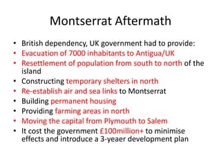
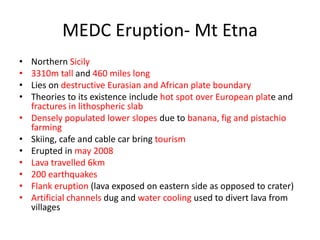
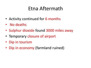
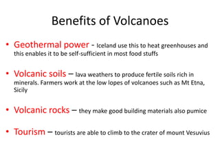
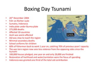
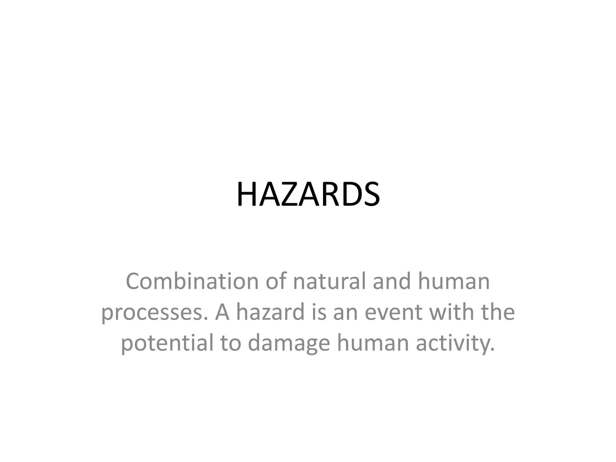
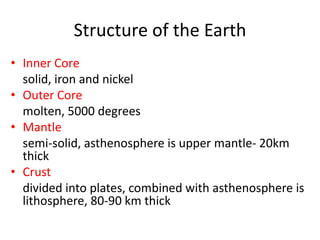
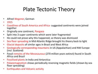
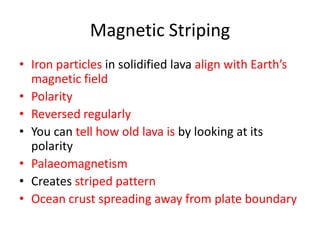
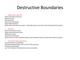
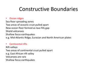
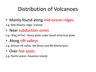
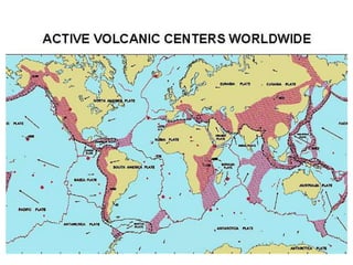
The document discusses plate tectonics and associated hazards. It describes the structure of the Earth's interior with an inner core, outer core, mantle and crust. The crust is divided into plates that move via convection currents in the asthenosphere. Plates interact at boundaries that are either constructive, destructive, or conservative. Destructive boundaries result in volcanoes, earthquakes and fold mountains through processes like subduction. Plate movement is evidenced by magnetic striping in ocean crust. Hazards vary depending on the type of boundary and are managed differently in LEDCs and MEDCs.
Groundwater forms when water infiltrates the earth's surface and collects underground. It is found in the saturated zone below the water table. Groundwater moves slowly through the pores and cracks in soil, sand, and rock. Over time, groundwater can cause erosion and dissolve limestone bedrock to form caves, sinkholes, and karst topography.
Every continent or island is bordered by a long or short coastline. Coastline is the line separating the land and sea. Coastal zones are the transition zones between terrestrial and marine habitat. They form an interface between land and oceanic natural processes. Coastal areas also are varied in their topography, climate and vegetation. Some are sandy beaches, rocky shores, with or without tidal inlets. The climate of a coast are controlled by the land and sea breezes and the humidity controlled by marine water. Waves are powerful tools for constructive and destructive activities. Hence. the geomorphology of beach, materials and processes are always not constant due to the impact of everlasting action of tides, waves and currents.
This document provides an overview of structural geology, including different types of geological structures such as folds, faults, and joints. It defines key terms used in structural geology like strike, dip, limbs, and plunge. It describes different types of folds like anticlines and synclines. It also explains faults, describing components like the hanging wall and footwall, and types of faults including normal, reverse, thrust, strike-slip, and oblique slip faults. Finally, it briefly discusses joints and types like columnar and sheet joints. The study of structural geology is important for understanding rock deformation and identifying structures that can form traps for resources like oil and gas.
This document summarizes channel and valley landforms, processes, and concepts. It describes characteristics of upper, middle, and lower course valleys including V-shaped valleys with interlocking spurs in the upper course. Middle courses have wider valleys and floodplains with the first signs of meanders. Lower courses have well-developed meanders and wide floodplains. Specific landforms like waterfalls, rapids, potholes, and braided channels are also summarized. Concepts discussed include regimes, capacity, competence, hydraulic radius, long profiles, rejuvenation, base level, thalwegs, and meander migration.
The document discusses the rock cycle, which describes how rocks are formed and change over time. It begins with igneous rock, which forms from cooling magma and lava. Sedimentary rock forms from compressed sediments over millions of years. Metamorphic rock forms from existing rocks undergoing changes in temperature and pressure. The rock cycle is thus completed as metamorphic rocks may be uplifted and eroded to form new sediments, closing the loop.
Petrology is the study of rocks and their origins, compositions, textures, and structures. There are three main types of rocks: igneous rocks formed from cooled magma, sedimentary rocks formed from compressed sediments, and metamorphic rocks formed from existing rocks subjected to heat and pressure. Rocks are constantly changing between these types through geological processes in the rock cycle, powered by Earth's interior heat and the energy from the sun. Igneous rocks can become sedimentary rocks through weathering and erosion then become metamorphic rocks through burial and increased heat and pressure, and metamorphic rocks can melt to form new magma and igneous rocks.
Pyroxene Group of Minerals, MSc. Geology
It contains Pyroxene Group of Minerals
Clinopyroxene
Orthopyroxene
examples with physical and optical properties of minerals of orthopyroxene and clinopyroxene group.
IUGS Classification
References .
It will help in MSc Pyroxene Group of Minerals entitled Presentations as well as notes for exams of MSc program under Geology Honors.
I had presented it in my 1st Semester presentation of Pyroxene Group of Minerals in Jiwaji University, Gwalior, Madhya Pradesh, India
This document discusses the geology of diamonds and major diamond deposits around the world. It provides details on the formation of kimberlite pipes, which are the primary source of diamonds. Major current and historical alluvial and kimberlite diamond mines are listed for countries in Africa, Asia, Australia, North and South America. The geology and historical mining methods of alluvial diamond deposits in South Africa are described. Examples of large, high-quality diamonds recovered from Rockwell Diamonds' projects in South Africa are given along with their sale prices. The document closes with a Native legend about the spiritual origin of diamonds in South Africa's Northern Cape Province.
Biogeo lec 7 glaciation and the pleistoceneMatt Robinson
The document discusses glaciation and biogeography during the Pleistocene epoch. It describes the extent and causes of glaciation, including continental ice sheets covering one third of the earth's land mass. It discusses Milankovitch cycles and feedback effects that influenced glacial and interglacial periods. During glacial maxima, unglaciated regions were cooler and wetter while tropical regions were drier. Biogeographic responses of terrestrial biotas included shifts in climatic zones and sea level changes affecting island populations. Refugia like Nunataks provided opportunities for genetic divergence. Glacial lakes and pluvial lakes in arid regions fragmented habitats. Alternative hypotheses for Pleistocene extinctions beyond
The document describes glaciers and periglacial landforms and processes. It defines different types of glaciers and explains glacial processes like formation, movement, erosion, transportation and deposition. This creates landforms like moraines, drumlins and eskers. Periglacial landscapes lacking glacial ice are also described, featuring permafrost and patterned ground. The Pleistocene epoch is summarized, noting continental glaciation, sea level changes, and paleoclimate studies of past climate variations.
This document describes various sedimentary environments including continental, transitional, marine, and others. Continental environments include alluvium deposited by rivers, aeolian sediments deposited by wind, fluvial sediments from streams and rivers, and lacustrine sediments from lakes. Marginal marine environments along the shore include beaches, barrier islands, lagoons, estuaries, and tidal flats. Marine environments discussed are the continental shelf, reefs, continental slope, continental rise, and abyssal plain. Characteristics of sediments and deposition in each environment are provided.
The document discusses the geological concept of isostasy. Isostasy refers to the principle of buoyancy where land masses float on the denser underlying mantle material. It explains that mountains create indentations in the earth's crust similar to placing a heavy object on a rubber ball. It also describes early theories on isostasy from Clarence Dutton, who coined the term, and Sir George Airy, who proposed that land masses float with varying thickness but uniform density. The concept was later refined by A. Pratt to propose uniform depth but varying density between land masses.
Surface currents are driven mainly by wind and move large amounts of water across oceans, influencing global climate. Deep currents form due to differences in water density from temperature and salinity and are not wind-driven. Major surface currents like the Gulf Stream distribute heat from the equator to poles, warming areas like northern Europe. El Niño is a periodic warming of tropical Pacific waters that alters weather worldwide and impacts fisheries and agriculture through changed rainfall and storms. Scientists monitor oceans to improve understanding and forecasts of El Niño events and their far-reaching climatic effects.
This document discusses the concept of isostasy, which refers to the equilibrium between the continental and oceanic crust due to gravitational forces. It was first defined in 1889 by American geologist Clarence Dutton. The main points are that the continental crust must be composed of lighter materials than the ocean floor to remain in equilibrium. Also, wherever the continental crust is thinner under the oceans, it extends below the ocean floor to maintain equilibrium. Early evidence for isostasy came from Pierre Bouguer's 1735 expedition to the Andes mountains, where he observed smaller than expected gravitational attraction that indicated compensation of the mountains' mass.
Kaikrishna from the Department of Geology at Kakatiya University in Warangal, Telangana, India discusses the classification of silicate minerals. Silicate minerals constitute about 90% of the Earth's crust and are composed of silicon and oxygen atoms arranged in tetrahedra. These tetrahedra can be arranged as individual units, chains, sheets, or three-dimensional networks. There are six major groups of silicate structures classified based on their atomic arrangement: neosilicates, sorosilicates, cyclosilicates, inosilicates, phyllosilicates, and tectosilicates.
DIASTROPHISM - FOLDING FAULTING AND MOREJsjxbs Kfkfnd
Diastrophism is the process of deformation of the Earth's crust which involves folding and faulting. Diastrophism can be considered part of geotectonics.
The document discusses the geological action of rivers and their role in shaping landscapes. It describes how river systems erode, transport, and deposit sediment through various processes like meandering, delta formation, and flooding. Key landforms created by rivers include valleys, floodplains, terraces, and alluvial fans. The document also explains how urbanization has impacted river flow and sediment transport.
Structural geology is the study of the three-dimensional of the rock units with respect to their deformational histories, Structure is spatial and geometrical configuration of rock components.
Structures are classified into two types:
Primary structures.
Secondary structures
Primary structures
Structures that form during deposition or crystallization of the rock, are the result of two processes:
Settling of solid particles from fluid medium in which they have been suspended, in most of the sedimentary rocks.
Crystallization of mineral grains from a liquid in which they have been dissolved as in igneous rocks.
Shear zones are zones of highly strained rock that form under brittle, ductile, or intermediate conditions. They record a history of deformation and can indicate the sense and amount of displacement. There are several types of shear zones defined by the dominant deformation mechanism (brittle, ductile, semibrittle, brittle-ductile). Determining the sense of shear is important and can be achieved through studying offset markers, foliation patterns, shear bands, inclusion shapes, and other indicators exposed in the shear zone.
1) Kerala is located on the southwest coast of India between the Arabian Sea and the Western Ghats mountains. It has varied geology consisting of Precambrian crystalline rocks, Tertiary sedimentary rocks, and recent sediments.
2) The oldest rocks are Precambrian and include khondalite, charnockite, sargur schists, and dharwar schists, as well as basic and ultrabasic rocks and granites. Tertiary sediments overlie the Precambrian rocks and include the Vaikom, Quilon, and Warkalli formations dating to the Miocene-Pliocene periods.
3) Recent deposits include peat beds, sand bars, and
This document provides an overview of igneous rocks and their formation. It discusses that igneous rocks form from the cooling of molten magma or lava. The cooling rate affects crystal size - slower cooling produces larger crystals and faster cooling produces smaller crystals. Intrusive igneous rocks cool slowly underground and have coarse grains, while extrusive rocks cool quickly at the surface and have fine grains. Texture is determined by crystal size and arrangements. Examples of textures discussed are phaneritic, aphanitic, porphyritic, glassy and pyroclastic.
The document discusses plate tectonics and the different types of plate boundaries. It explains that tectonic plates are giant pieces of the Earth's crust that are constantly moving. There are three main types of plate boundaries: constructive boundaries where plates move apart and new crust is formed, destructive boundaries where one plate moves under another, and conservative boundaries such as transform faults that offset movement at plate margins. The document also includes quiz questions to test understanding of these concepts.
Deltas- types, formation, case studiesNishay Patel
Deltas are landforms formed at river mouths where sediment is deposited as the river enters a sea or lake. They are fan-shaped areas that can span hundreds of kilometers. The Indus River Delta in Pakistan covers 40,000 square kilometers and has a complex network of distributaries. Deltas form as rivers slow down at their mouths, causing sediment to flocculate and settle, building up over time. Different types of deltas include bird's foot, arcuate, and cuspate shapes, depending on factors like tidal influence. Deltas provide fertile land and resources but are also at high risk of flooding and channel migration due to their unstable sediments.
Mass movements are the downslope movement of material under the direct influence of gravity. They are classified based on their rate of motion and the material involved. Major types include falling, sliding, flowing, and heaving. Factors that influence slope stability and failure include steep slope angles, weathering, water content, vegetation loss, slope dip, and trigger mechanisms such as earthquakes or heavy rainfall.
An oxbow lake is a crescent-shaped lake that forms when a meander loop in a river is cut off from the main channel. Over time, erosion and deposition cause the neck of the meander loop to narrow until it disappears completely, separating the loop from the river and leaving behind a free-standing crescent-shaped body of water known as an oxbow lake.
This document summarizes the three types of plate boundaries:
1) When an oceanic plate meets a continental plate, the oceanic plate is subducted beneath the continental plate. This can form deep trenches and volcanic island arcs.
2) When two oceanic plates meet, one plate subducts beneath the other, forming ocean trenches and island arcs offshore.
3) When two continental plates meet, they are forced upwards to form fold mountains rather than subducting. This leads to earthquakes but no volcanic activity. Mountain ranges like the Himalayas and Andes are examples of this type of plate boundary.
There are two types of crust - continental and oceanic - and three directions of plate movement - converging, diverging, and passive. This results in six plate boundary types: destructive (oceanic-continental convergence), destructive (oceanic-oceanic convergence), destructive (continental-continental collision), constructive (diverging at ocean ridges), constructive (continental rifting), and conservative (passive movement). Each boundary type creates different landforms and hazards due to the associated geological processes.
PHIVOLCS monitors earthquakes in the Philippines using a network of over 100 seismic stations. Earthquakes are natural occurrences caused by the slow motion of tectonic plates. The Philippines is located in a seismically active area between several plates. PHIVOLCS provides information to the public on earthquake locations, intensities, and issues advisories. Larger earthquakes are inevitable given the Philippines' position between plates and presence of faults.
The document discusses tectonic plate processes and earthquakes. It describes how earthquakes occur at plate boundaries due to stresses from plate movements. Earthquakes at divergent boundaries pose little risk while those at convergent boundaries can be very hazardous, as seen in the 1985 Mexico City earthquake that killed over 10,000 people. The document also discusses earthquake measurement scales, the different types of seismic waves, and secondary hazards like tsunamis, landslides and liquefaction that can amplify earthquake damage.
Study of earthquake hazards or disaster Jahangir Alam
Earthquake Hazards
Definition of Hazard
Liquefaction
Ground Shaking
Ground Displacement
Flooding
Tsunami
Fire
Types of Hazard
Natural Hazards as Earthquakes
What Are Earthquake Hazards?
Ground Shaking:
Earthquakes result from a sudden release of energy in the Earth's crust that causes seismic waves and potential secondary hazards like tsunamis. They can cause significant damage depending on factors like their depth, the type of buildings and infrastructure, and secondary hazards. Major earthquake and tsunami events in recent history include the 2004 Sumatra earthquake and tsunami that killed over 250,000 people in Indonesia.
This document discusses earthquake hazards and mitigation. It notes that approximately 500,000 earthquakes occur each year, with around 100 being potentially dangerous. Major earthquakes typically occur annually and can release large amounts of seismic energy. Earthquakes cause damage through ground shaking, liquefaction, landslides, fires, and tsunamis. Mitigation strategies include avoiding hazard areas, building earthquake resistant structures using special materials and construction techniques, improving weak soils, and reducing seismic demand on structures. Proper architectural design and reinforcement of masonry and reinforced concrete buildings can also improve earthquake resistance.
This document discusses natural hazards caused by tectonic and climate-related events. It provides details on the internal structure of the Earth, including the crust and mantle. It then focuses on plate tectonics, explaining the three main types of plate boundaries and associated landforms. Specific examples are given for each plate boundary type. The document also addresses causes of earthquakes and their impacts, as well as types and characteristics of volcanoes.
The earth is made up of layers including the crust, mantle, and core. The crust is broken into tectonic plates that move due to convection currents in the mantle, causing phenomena like continental drift. There are three types of plate boundaries: constructive where new crust is formed, destructive where plates are subducted, and conservative where plates slide past each other causing earthquakes. Most volcanic and earthquake activity occurs along plate boundaries. Examples of resulting landforms include mid-ocean ridges, volcanic islands, and fold mountains. Historic earthquakes and tsunamis like those in the Philippines in 2013 and Japan in 2011 illustrate the destructive power of plate tectonic forces.
The document provides information about earthquakes and volcanoes. It begins by defining an earthquake and volcano, and describes the formation of earthquakes. It then discusses plate tectonics and the different types of faults, earthquakes, and volcanoes. Examples are given of notable historical earthquakes and volcanic eruptions around the world, including in Chile, Alaska, Japan, Mount St. Helens, and Iceland. Earthquakes that have impacted Pakistan are also summarized.
This document summarizes key concepts related to orogenesis including folding, faulting, and volcanism. It describes three main types of faulting - normal, reverse/thrust, and transform/strike-slip. Examples of related landforms like horsts and grabens formed by normal faulting are provided. Transform faults like the San Andreas are described as forming shallow linear valleys with little volcanism. The earthquake cycle and seismic wave types are summarized. Historic earthquakes in California like the 1857 Fort Tejon and 1906 San Francisco quakes are overviewed. Finally, the document classifies volcanoes and provides examples of explosive composite cones and effusive shield volcanoes formed at hot spots.
This document contains notes for an 'O' level Geography exam. It includes sections on physical geography such as plate tectonics, volcanoes, earthquakes, weather and climate. It also covers human geography topics like tourism, industries and development. The notes provide definitions, explanations and examples for various concepts in the syllabus. Version notes at the top indicate that the author is regularly updating and improving the content.
Plate tectonics involves the slow movement of tectonic plates across the Earth's surface, driven by convection currents in the mantle. Alfred Wegener first proposed continental drift in 1915, but it was not until the 1960s that seafloor spreading provided evidence that plates move independently. There are 7 major and many minor tectonic plates that either move apart at mid-ocean ridges or come together, causing earthquakes and volcanic activity at plate boundaries. Hazards are greatest where plates meet and include earthquakes, tsunamis, and eruptions that depend on the plate boundary setting and composition of the colliding plates.
Plate tectonics refers to the theory that the Earth's crust is divided into plates that constantly move atop the mantle. The plates are composed of rigid tectonic plates that move relative to one another, riding on top of the hotter, softer mantle material. There are three main types of plate boundaries - divergent where plates move apart and new crust is generated, convergent where plates collide and one slides under the other, and transform where plates slide past one another. The movement and interaction of tectonic plates causes earthquakes and creates geologic features like ocean basins, mountains, volcanoes, and trenches.
Plate tectonics refers to the theory that the Earth's crust is divided into plates that constantly move atop hotter mantle material. The plates are composed of rigid crustal rock and float on a soft layer in the mantle. Convection currents in the mantle drive the slow movement of the plates. There are three main types of plate boundaries - divergent where plates spread apart and new crust forms, convergent where plates collide and one slides under the other, and transform where plates slide past each other. Plate tectonics helps explain phenomena like earthquakes, volcanoes, and mountain building.
Plate tectonics refers to the theory that the Earth's crust is divided into plates that constantly move atop the mantle. The plates are composed of rigid tectonic plates that move relative to one another, riding on top of the hotter, softer mantle material. There are three main types of plate boundaries - divergent where plates move apart and new crust is generated, convergent where plates collide and one slides under the other, and transform where plates slide past one another. The movement and interaction of tectonic plates causes earthquakes and creates geologic features like ocean basins, mountains, volcanoes, and ocean trenches.
Plate tectonics refers to the theory that the Earth's crust is divided into plates that constantly move atop the mantle. The plates are composed of rigid tectonic plates that move relative to one another, riding on top of the hotter, softer mantle material. There are three main types of plate boundaries - divergent boundaries where new crust is generated; convergent boundaries where plates collide and one slides under the other; and transform boundaries where plates slide past one another. The movement of tectonic plates results in earthquakes and volcanic activity and has shaped the features of Earth's surface over millions of years.
Plate tectonics refers to the theory that the Earth's crust is divided into plates that constantly move atop the mantle. The plates are composed of rigid tectonic plates that move relative to one another, riding on top of the hotter, softer mantle material. There are three main types of plate boundaries - divergent where plates move apart and new crust is generated, convergent where plates collide and one slides under the other, and transform where plates slide past one another. The movement and interaction of tectonic plates causes earthquakes and creates geologic features like ocean basins, mountains, volcanoes, and ocean trenches.
Plate tectonics refers to the theory that the Earth's crust is divided into plates that constantly move atop the mantle. The plates are composed of rigid tectonic plates that move relative to one another, riding on top of the hotter, softer mantle material. There are three main types of plate boundaries - divergent where plates move apart and new crust is generated, convergent where plates collide and one slides under the other, and transform where plates slide past one another. The movement and interaction of tectonic plates at their boundaries results in geological phenomena like earthquakes, volcanic activity, and mountain building.
Plate tectonics refers to the theory that the Earth's crust is divided into plates that constantly move atop the mantle. The plates are composed of rigid tectonic plates that move relative to one another, riding on top of the hotter, softer mantle material. There are three main types of plate boundaries - divergent boundaries where new crust is generated; convergent boundaries where plates collide and one slides under the other; and transform boundaries where plates slide past one another. The movement of tectonic plates directly causes earthquakes and creates geologic features such as ocean basins, mountains, volcanoes, and oceanic trenches.
Volcanoes form at plate boundaries where magma rises to the surface. There are two main types - acid/explosive volcanoes found at subduction zones and basaltic/shield volcanoes at hotspots. Mount Vesuvius near Naples, Italy is a composite acid volcano that has erupted frequently throughout history, most notably destroying Pompeii in 79AD. With over 3 million people now living nearby, Vesuvius presents a significant risk and authorities monitor it closely and have evacuation plans in place in case of a future eruption.
The document summarizes key aspects of sea floor geology and ocean basins. It describes how sea floors are geologically distinct from continents and shaped by perpetual cycles of creation and destruction. It also outlines the four main ocean basins - Pacific, Atlantic, Indian, and Arctic - and notes that the Pacific is the deepest and largest while the Arctic is the smallest and shallowest. Geological processes determine coastal landforms and water depths/bottom types, regulating life on Earth.
This document provides an overview of important concepts in geology. It introduces geology as the scientific study of the Earth, including its physical materials and forces that cause changes to its surface and interior. Key practical aspects of geology discussed are natural resources, geological hazards, and environmental protection related to resource extraction. The document also summarizes concepts of Earth's interior structure and heat engines, plate tectonics theory including different plate boundary types, and geological timescales.
This document appears to be an exam paper for a mathematics course. It contains instructions for candidates taking the exam, information about the structure and format of the exam, the exam questions themselves, and spaces for candidates to write their answers. The exam consists of 9 multiple choice and short answer questions testing a range of mathematics concepts and skills, including binomial expansion, solving equations, factorizing polynomials, calculating areas, and using integration rules. Candidates are instructed to show their working, write answers in the spaces provided, and include relevant working and steps to receive full marks. The first 3 questions are presented for summary.
This document is an exam paper for a Core Mathematics C1 exam. It contains 10 questions testing calculus, algebra, and geometry skills. The paper provides instructions for candidates to write their details, check they have the correct paper, and answer all questions in the spaces provided. It advises candidates to show working and gives information on question marks and the total exam marks.
This document is an exam paper for Mechanics M1. It contains instructions for candidates on how to fill out their details, information about materials allowed and the structure of the paper. The paper contains 7 questions worth a total of 75 marks. It directs candidates to show working, label answers and provide responses in the spaces provided. Question 1 involves two particles colliding and calculates their speeds before and after, as well as determining the value of m based on impulse.
This document contains an exam paper for Core Mathematics C4. It includes 5 questions testing calculus skills. The paper provides instructions for candidates, advising them to show working, write answers in the spaces provided, and use an appropriate degree of accuracy when using a calculator. It also lists the materials candidates may use and information about the duration, marks and structure of the exam.
This document contains an exam paper for a Core Mathematics C3 Advanced exam. It provides instructions for candidates on how to fill out their details, contains 9 questions to answer, and specifies the time allotted and materials allowed. Candidates are to show their working and answers must be written in the spaces provided after each question.
This document appears to be an exam paper for a mechanics course. It contains 6 multiple part questions testing concepts in mechanics such as forces, kinematics, and dynamics. The questions provide contextual word problems and diagrams requiring students to set up and solve equations to find requested values. The exam paper provides space for work and answers and includes instructions for candidates on providing responses. It is signed and includes information for examiners.
This document provides instructions and information for a mathematics exam. It includes:
1) Details about the exam such as the date, time allotted, and materials allowed.
2) Instructions for candidates on how to identify their work and provide their information.
3) Information for candidates about the structure of the exam including the total number and types of questions, and the total marks available.
4) Advice to candidates about showing their working and obtaining full credit.
This document provides information about a Core Mathematics C3 exam taken by Edexcel students. It includes instructions for students taking the exam, information about materials allowed and provided, and 8 questions testing various calculus, geometry, and trigonometry concepts. The exam is 1 hour and 30 minutes long and contains a total of 75 marks across the 8 questions. Students are advised to show their working clearly and label answers to parts of questions.
The UK has a mixed economy with both public and private sectors. Primary production involves acquiring raw materials through activities like mining, drilling, and tapping. Secondary production manufactures and assembles raw materials into components and products. Tertiary production supports production and distribution through services like transportation, retail, and insurance. These stages form the chain of production that provides consumers with finished goods.
The document discusses who is interested in a company's annual accounts and why. Shareholders and potential investors are interested to understand the profitability and financial performance of the company. Annual accounts contain key financial ratios that analyze various aspects of a company's sales, costs, overheads, gross profits and net profits. These ratios help stakeholders evaluate the company's efficiency in controlling costs and expenses, and determining how well the company utilizes its resources to be profitable. The document also provides examples of calculating common ratios like gross profit percentage and explains how different ratios are interrelated.
The document provides revision notes on various mathematics topics including:
1) Binomial expansions, partial fractions, trigonometry formulas, and techniques for integration like volumes of revolution.
2) Parametric equations, vectors, vector equations, planes, and differential equations.
3) Details are given for solving problems involving these topics, such as using compound angle formulas, rewriting algebraic fractions as partial fractions, and separating variables to solve first-order differential equations.
This document covers several topics in calculus including differentiation, implicit differentiation, transformations, trigonometry, vectors, and integration.
This document discusses concepts related to moments, including the definition of moment of force as force multiplied by perpendicular distance (Fd), that anticlockwise moments are positive, and that for a rigid body in equilibrium the total moment about any point must equal zero. It also notes that when a rod rests on two supports and pivots about one, the reaction at the other support will be zero.
Merry Hill shopping centre was built between 1984-1989 on the site of the former Round Oak Steelworks in Brierley Hill. It has over 185 shops and attracts many shoppers with its large stores and 10,000 free parking spaces. However, it had negative impacts on surrounding towns like Dudley, leading to high vacancy rates and declining trade in their town centres. Future plans aim to connect Merry Hill to Brierley Hill town centre and redevelop the area with new leisure facilities, housing, and businesses to better integrate the shopping centre.
Contemporary sustainability issues in urban areasanicholls1234
This document discusses sustainability issues related to waste management in cities. It outlines the waste hierarchy as the cornerstone of waste minimization strategies. Political bodies like the EU and UK government produce targets to reduce landfill waste and increase recycling rates. Local authorities consider strategies like fining households that produce above average waste. Waste management methods include disposal in landfills or through incineration, as well as recycling through physical or biological reprocessing. Reduction methods involve reuse, repair, and designing items to use less material.
The tropical rainforests are located near the equator and experience high temperatures and heavy rainfall year-round. However, rainforests are being cut down at alarming rates for agriculture, settlements, ranching, logging, mining, dams, and roads. This widespread deforestation is harming the environment by causing soil erosion, accelerating global warming, and threatening countless species with extinction. Global warming occurs as fewer trees convert carbon dioxide to oxygen, trapping more heat in the atmosphere. Continued deforestation may worsen problems like melting glaciers and rising global temperatures.
Blues Revision- Everything you need to knowanicholls1234
This document provides background information on Miles Davis' album "Kind of Blue" and the track "All Blues". It details the composers, musicians, structure, harmony, and modal approach of the jazz piece. Key aspects covered include the 12 bar blues form in G major, solos by Davis, Adderley, and Coltrane over modal scales, and the accompaniment and ornamentation in the recording.
This document provides information about the Indian classical music form of Rag Desh. It discusses the drone, tala (rhythmic cycle), and instrumentation used in three different recorded pieces. It also outlines various melodic and rhythmic playing techniques commonly found in Rag Desh performances, such as improvisation, meends, tans, chands, tihais, jhallas, and bols. The document compares and contrasts the different elements used across the three pieces.
Minimalism- Everything you need to know!anicholls1234
Steve Reich's "Electric Counterpoint" is a minimalist work composed in 1987 for an electric guitarist. It uses layering and phase shifting techniques where short melodic motifs are played across multiple tracks of electric guitars and bass. The piece has three movements and is composed of short repeating ostinato patterns that build up in complexity through the layering of guitar and bass parts.
The document provides information about Arnold Schoenberg's piece "Peripetie" including definitions of musical terms used in the piece such as hexachord, diminution, and glissando. It gives one example of Schoenberg's use of canon and explains that atonal music has no set key or tonality. The document also identifies that symbols "H" and "N" represent the most and second most important melodies. It cites five features showing the piece was composed in the 20th century including its atonal angular style, use of extended techniques, focus on timbre, and lack of clear form.
UiPath Test Automation using UiPath Test Suite series, part 6DianaGray10
Welcome to UiPath Test Automation using UiPath Test Suite series part 6. In this session, we will cover Test Automation with generative AI and Open AI.
UiPath Test Automation with generative AI and Open AI webinar offers an in-depth exploration of leveraging cutting-edge technologies for test automation within the UiPath platform. Attendees will delve into the integration of generative AI, a test automation solution, with Open AI advanced natural language processing capabilities.
Throughout the session, participants will discover how this synergy empowers testers to automate repetitive tasks, enhance testing accuracy, and expedite the software testing life cycle. Topics covered include the seamless integration process, practical use cases, and the benefits of harnessing AI-driven automation for UiPath testing initiatives. By attending this webinar, testers, and automation professionals can gain valuable insights into harnessing the power of AI to optimize their test automation workflows within the UiPath ecosystem, ultimately driving efficiency and quality in software development processes.
What will you get from this session?
1. Insights into integrating generative AI.
2. Understanding how this integration enhances test automation within the UiPath platform
3. Practical demonstrations
4. Exploration of real-world use cases illustrating the benefits of AI-driven test automation for UiPath
Topics covered:
What is generative AI
Test Automation with generative AI and Open AI.
UiPath integration with generative AI
Speaker:
Deepak Rai, Automation Practice Lead, Boundaryless Group and UiPath MVP
Maruthi Prithivirajan, Head of ASEAN & IN Solution Architecture, Neo4j
Get an inside look at the latest Neo4j innovations that enable relationship-driven intelligence at scale. Learn more about the newest cloud integrations and product enhancements that make Neo4j an essential choice for developers building apps with interconnected data and generative AI.
Encryption in Microsoft 365 - ExpertsLive Netherlands 2024Albert Hoitingh
In this session I delve into the encryption technology used in Microsoft 365 and Microsoft Purview. Including the concepts of Customer Key and Double Key Encryption.
DevOps and Testing slides at DASA ConnectKari Kakkonen
My and Rik Marselis slides at 30.5.2024 DASA Connect conference. We discuss about what is testing, then what is agile testing and finally what is Testing in DevOps. Finally we had lovely workshop with the participants trying to find out different ways to think about quality and testing in different parts of the DevOps infinity loop.
GraphSummit Singapore | The Future of Agility: Supercharging Digital Transfor...Neo4j
Leonard Jayamohan, Partner & Generative AI Lead, Deloitte
This keynote will reveal how Deloitte leverages Neo4j’s graph power for groundbreaking digital twin solutions, achieving a staggering 100x performance boost. Discover the essential role knowledge graphs play in successful generative AI implementations. Plus, get an exclusive look at an innovative Neo4j + Generative AI solution Deloitte is developing in-house.
Alt. GDG Cloud Southlake #33: Boule & Rebala: Effective AppSec in SDLC using ...James Anderson
Effective Application Security in Software Delivery lifecycle using Deployment Firewall and DBOM
The modern software delivery process (or the CI/CD process) includes many tools, distributed teams, open-source code, and cloud platforms. Constant focus on speed to release software to market, along with the traditional slow and manual security checks has caused gaps in continuous security as an important piece in the software supply chain. Today organizations feel more susceptible to external and internal cyber threats due to the vast attack surface in their applications supply chain and the lack of end-to-end governance and risk management.
The software team must secure its software delivery process to avoid vulnerability and security breaches. This needs to be achieved with existing tool chains and without extensive rework of the delivery processes. This talk will present strategies and techniques for providing visibility into the true risk of the existing vulnerabilities, preventing the introduction of security issues in the software, resolving vulnerabilities in production environments quickly, and capturing the deployment bill of materials (DBOM).
Speakers:
Bob Boule
Robert Boule is a technology enthusiast with PASSION for technology and making things work along with a knack for helping others understand how things work. He comes with around 20 years of solution engineering experience in application security, software continuous delivery, and SaaS platforms. He is known for his dynamic presentations in CI/CD and application security integrated in software delivery lifecycle.
Gopinath Rebala
Gopinath Rebala is the CTO of OpsMx, where he has overall responsibility for the machine learning and data processing architectures for Secure Software Delivery. Gopi also has a strong connection with our customers, leading design and architecture for strategic implementations. Gopi is a frequent speaker and well-known leader in continuous delivery and integrating security into software delivery.
How to Get CNIC Information System with Paksim Ga.pptxdanishmna97
Pakdata Cf is a groundbreaking system designed to streamline and facilitate access to CNIC information. This innovative platform leverages advanced technology to provide users with efficient and secure access to their CNIC details.
In the rapidly evolving landscape of technologies, XML continues to play a vital role in structuring, storing, and transporting data across diverse systems. The recent advancements in artificial intelligence (AI) present new methodologies for enhancing XML development workflows, introducing efficiency, automation, and intelligent capabilities. This presentation will outline the scope and perspective of utilizing AI in XML development. The potential benefits and the possible pitfalls will be highlighted, providing a balanced view of the subject.
We will explore the capabilities of AI in understanding XML markup languages and autonomously creating structured XML content. Additionally, we will examine the capacity of AI to enrich plain text with appropriate XML markup. Practical examples and methodological guidelines will be provided to elucidate how AI can be effectively prompted to interpret and generate accurate XML markup.
Further emphasis will be placed on the role of AI in developing XSLT, or schemas such as XSD and Schematron. We will address the techniques and strategies adopted to create prompts for generating code, explaining code, or refactoring the code, and the results achieved.
The discussion will extend to how AI can be used to transform XML content. In particular, the focus will be on the use of AI XPath extension functions in XSLT, Schematron, Schematron Quick Fixes, or for XML content refactoring.
The presentation aims to deliver a comprehensive overview of AI usage in XML development, providing attendees with the necessary knowledge to make informed decisions. Whether you’re at the early stages of adopting AI or considering integrating it in advanced XML development, this presentation will cover all levels of expertise.
By highlighting the potential advantages and challenges of integrating AI with XML development tools and languages, the presentation seeks to inspire thoughtful conversation around the future of XML development. We’ll not only delve into the technical aspects of AI-powered XML development but also discuss practical implications and possible future directions.
A tale of scale & speed: How the US Navy is enabling software delivery from l...sonjaschweigert1
Rapid and secure feature delivery is a goal across every application team and every branch of the DoD. The Navy’s DevSecOps platform, Party Barge, has achieved:
- Reduction in onboarding time from 5 weeks to 1 day
- Improved developer experience and productivity through actionable findings and reduction of false positives
- Maintenance of superior security standards and inherent policy enforcement with Authorization to Operate (ATO)
Development teams can ship efficiently and ensure applications are cyber ready for Navy Authorizing Officials (AOs). In this webinar, Sigma Defense and Anchore will give attendees a look behind the scenes and demo secure pipeline automation and security artifacts that speed up application ATO and time to production.
We will cover:
- How to remove silos in DevSecOps
- How to build efficient development pipeline roles and component templates
- How to deliver security artifacts that matter for ATO’s (SBOMs, vulnerability reports, and policy evidence)
- How to streamline operations with automated policy checks on container images
Full-RAG: A modern architecture for hyper-personalizationZilliz
Mike Del Balso, CEO & Co-Founder at Tecton, presents "Full RAG," a novel approach to AI recommendation systems, aiming to push beyond the limitations of traditional models through a deep integration of contextual insights and real-time data, leveraging the Retrieval-Augmented Generation architecture. This talk will outline Full RAG's potential to significantly enhance personalization, address engineering challenges such as data management and model training, and introduce data enrichment with reranking as a key solution. Attendees will gain crucial insights into the importance of hyperpersonalization in AI, the capabilities of Full RAG for advanced personalization, and strategies for managing complex data integrations for deploying cutting-edge AI solutions.
Essentials of Automations: The Art of Triggers and Actions in FMESafe Software
In this second installment of our Essentials of Automations webinar series, we’ll explore the landscape of triggers and actions, guiding you through the nuances of authoring and adapting workspaces for seamless automations. Gain an understanding of the full spectrum of triggers and actions available in FME, empowering you to enhance your workspaces for efficient automation.
We’ll kick things off by showcasing the most commonly used event-based triggers, introducing you to various automation workflows like manual triggers, schedules, directory watchers, and more. Plus, see how these elements play out in real scenarios.
Whether you’re tweaking your current setup or building from the ground up, this session will arm you with the tools and insights needed to transform your FME usage into a powerhouse of productivity. Join us to discover effective strategies that simplify complex processes, enhancing your productivity and transforming your data management practices with FME. Let’s turn complexity into clarity and make your workspaces work wonders!
Generative AI Deep Dive: Advancing from Proof of Concept to ProductionAggregage
Join Maher Hanafi, VP of Engineering at Betterworks, in this new session where he'll share a practical framework to transform Gen AI prototypes into impactful products! He'll delve into the complexities of data collection and management, model selection and optimization, and ensuring security, scalability, and responsible use.
In his public lecture, Christian Timmerer provides insights into the fascinating history of video streaming, starting from its humble beginnings before YouTube to the groundbreaking technologies that now dominate platforms like Netflix and ORF ON. Timmerer also presents provocative contributions of his own that have significantly influenced the industry. He concludes by looking at future challenges and invites the audience to join in a discussion.
Goodbye Windows 11: Make Way for Nitrux Linux 3.5.0!SOFTTECHHUB
As the digital landscape continually evolves, operating systems play a critical role in shaping user experiences and productivity. The launch of Nitrux Linux 3.5.0 marks a significant milestone, offering a robust alternative to traditional systems such as Windows 11. This article delves into the essence of Nitrux Linux 3.5.0, exploring its unique features, advantages, and how it stands as a compelling choice for both casual users and tech enthusiasts.
Goodbye Windows 11: Make Way for Nitrux Linux 3.5.0!
Geography notes volcanoes, Earthquakes, AQA
1. HAZARDS
Combination of natural and human
processes. A hazard is an event with the
potential to damage human activity.
2. Structure of the Earth
• Inner Core
solid, iron and nickel
• Outer Core
molten, 5000 degrees
• Mantle
semi-solid, asthenosphere is upper mantle- 20km
thick
• Crust
divided into plates, combined with asthenosphere is
lithosphere, 80-90 km thick
3. Plates
• Plates are 7 large pieces of the lithosphere
• They float on asthenosphere and move through
convection currents
• Continental
30-70 km thick, light in colour (mainly
granite), composed of SIAL (silicon, aluminium), lighter
than oceanic, over 1500 million years old
• Oceanic
6-10 km thick, dark (mainly basalt), SIMA (silicon
magnesium), heavier than continental, younger than
continental (200 million years old)
4. Plate Tectonic Theory
• Alfred Wegener, German
• 1915
• Coastlines of South America and Africa- suggested continents were joined
together
• Originally one continent, Pangaea
• Split into 3 super continents which were later fragmented
• He could not prove why this happened, so theory was dismissed
• Sea floor spreading in Mid Atlantic Ridge brought his theory back to light
• Glacial deposits of similar ages in Brazil and West Africa
• Geologically corresponding mountains in US (Appalachian) and NW Europe
(incl. Scotland)
• Fossil remains of the Mesosauraus (270 million years extinct) found in South
Africa and Brazil
• Fossilised plants in India and Antarctica
• Palaeomagnetism shows periodically reversing magnetic fields (shown by sea
floor spreading)
• Earthquakes and Volcanic activity
5. Magnetic Striping
• Iron particles in solidified lava align with Earth’s
magnetic field
• Polarity
• Reversed regularly
• You can tell how old lava is by looking at its
polarity
• Palaeomagnetism
• Creates striped pattern
• Ocean crust spreading away from plate boundary
6. Destructive Boundaries
• Andean-type subduction
Oceanic beneath continental
Deep sea trench
Fold mountains
Deep focus Earthquakes
Steep-sided volcanoes
Nazca under South American plate – Andes Mountains, Peru-Chile trench, Nevado del Ruiz volcano
• Island Arcs
Oceanic and oceanic crusts
Steep-sided volcanoes formed
Shallow sea trench
Deep-focus earthquakes
South American under Caribbean plate formed Caribbean Islands, Soufriere Hills, Marianas Islands
• Continental collision boundaries
Two continental crusts colliding
Sediments between plates rise up to form fold mountains
Deep focus earthquakes
e.g. The Himalayas- Indo-Australian and Eurasian plates
7. Constructive Boundaries
• Ocean ridges
Sea floor spreading zones
Two areas of oceanic crust pulled apart
New ocean floor formed as lava fills gap
Shield volcanoes
Shallow focus earthquakes
e.g. Mid-Atlantic Ridge, Eurasian and North American plates
• Continental rifts
Rift valleys
Two areas of continental crust pulled apart
e.g. East African rift valley
Volcanoes are rare
Shallow focus earthquakes
8. Conservative Boundaries
• Plates sliding parallel to each other
• Friction and tension build
• Shallow focus earthquakes
• E.g. San Andreas Fault, California
• Pacific vs. North American plates
• Moving in same direction at different speeds
• Pacific is faster (5-9cm/year)
• Can cause transform faults
9. Hot Spots
• E.g. Hawaiian Islands
• Hot Spot within pacific plate
• Radioactive elements within mantle
• Magma rises to surface in plumes, forming small
shield volcanoes
• Hot spots are rooted, but the movement of the
pacific plate has caused Island Chains
• Only the volcano above the hot spot is active-
Mauna Loa
• Pacific plate is moving in a NW direction
10. Intrusive Volcanicity
• It’s what happens when the magma cools
before it reaches the surface
• Often exposed years later after erosion
• Batholiths are an example of a bubble of
solidified magma, often hundreds of
kilometres in diameter
• E.g. Dartmoor
• Dykes radiate from batholiths
11. Extrusive Volcanicity
• When magma reaches the surface
• Formation depends on type of lava
• Lava plateaux formed from fissure eruptions-
flat landscapes due to basic lava
• E.g. Antrim Plateau, NI
• Volcanic forms e.g. Volcanoes, Geysers and
Mud volcanoes
12. Volcanic shapes
• Shield- basic lava, short and wide
e.g. Mauna Loa, Hawaii
• Dome- viscous lava, tall and steep
e.g. Puy district, France
• Cinder cone
e.g. Paricutin, Mexico
• Composite cone- pyramid shape, layers of ash and lava
e.g. Mt Etna, Sicily
• Calderas- gas build up explodes and removes summit
Krakatoa, Indonesia
13. Volcanic Eruptions
• Icelandic
gently flowing basalt lava from a fissure
• Hawaiian
basalt lava flowing from a central vent
• Vesuvian
violent explosion after long inactivity
• Kratatoan
violent eruption destroying entire cone base leaving crater
• Pelean
violent eruption with pyroclastic flows
• Plinean
violent eruption where lava and pyroclastic materials ejected e.g. Lava bombs
14. Distribution of Volcanoes
• Mainly found along mid-ocean ridges
e.g. Mid-Atlantic ridge- Iceland
• Near subduction zones
e.g. ‘Ring of Fire’- Nazca plate under South American plate
• Along rift valleys
e.g. African rift valley- Mt Kenya and Mt Kilamanjaro
• Over hot spots
e.g. Pacific ocean- Hawaiian islands
15.
16. Effects of Volcanic Activity
Primary
• Lava flow – threat to farmland and infrastructure
• Tephra – solid material of varying size ejected into the atmosphere
• Pyroclastic flows – hot, gas-charged, high velocity flows of gas and tephra, respiratory problems
• Volcanic gases – mainly carbon dioxide, killed 1700 people in 1986 at Lake Nyos, Cameroon
Secondary
• Lahars – volcanic mud flows, e.g. Nevado del Ruiz in 1985
• Flooding – melting of ice caps and glaciers e.g. Grimsvotn, Iceland 1996
• Tsunamis – giant sea waves e.g. Krakatoa, 1883 killing 30,000 in Sumatra
• Volcanic landslides
• Climatic change – volcanic debris in the atmosphere reduces global temperatures
18. Hazard Management - Protection
• Monitoring the volcano (leaves time for evacuation)
• Risk assessments (identifying those at greatest risk)
• Land use planning (avoid building in high-risk areas)
• Controlling lava flows (trenches, walls, dynamite, pouring water on slow moving lava to set)
• Technical and financial aid (for LEDW)
19. LEDC Eruption -Montserrat
• Soufriere Hills, Montserrat, Caribbean
• Dormant for 400 years
• July 1995, started steaming and small ash explosions
• 1996, pyroclastic flows, southern population in danger,
most had fled
• 1997, residents move back to south as volcano went
through a quiet phase
• June 1997- exploded, large pyroclastic flows destroyed
settlements (Plymouth, capital city) and killed 19
20. Montserrat Aftermath
• British dependency, UK government had to provide:
• Evacuation of 7000 inhabitants to Antigua/UK
• Resettlement of population from south to north of the
island
• Constructing temporary shelters in north
• Re-establish air and sea links to Montserrat
• Building permanent housing
• Providing farming areas in north
• Moving the capital from Plymouth to Salem
• It cost the government £100million+ to minimise
effects and introduce a 3-yeaer development plan
21. MEDC Eruption- Mt Etna
• Northern Sicily
• 3310m tall and 460 miles long
• Lies on destructive Eurasian and African plate boundary
• Theories to its existence include hot spot over European plate and
fractures in lithospheric slab
• Densely populated lower slopes due to banana, fig and pistachio
farming
• Skiing, cafe and cable car bring tourism
• Erupted in may 2008
• Lava travelled 6km
• 200 earthquakes
• Flank eruption (lava exposed on eastern side as opposed to crater)
• Artificial channels dug and water cooling used to divert lava from
villages
22. Etna Aftermath
• Activity continued for 6 months
• No deaths
• Sulphur dioxide found 3000 miles away
• Temporary closure of airport
• Dip in tourism
• Dip in economy (farmland ruined)
23. Benefits of Volcanoes
• Geothermal power - Iceland use this to heat greenhouses and
this enables it to be self-sufficient in most food stuffs
• Volcanic soils – lava weathers to produce fertile soils rich in
minerals. Farmers work at the low lopes of volcanoes such as Mt Etna,
Sicily
• Volcanic rocks – they make good building materials also pumice
• Tourism – tourists are able to climb to the crater of mount Vesuvius
24. Earthquakes
• An earthquake is oscillation of the earth’s crust
• Measured on a Richter scale (logarithmic)
• May also be measured on the Mercalli scale
• Triggered mostly by plate boundaries moving but also
by movement in fault lines, volcanic activity and
human activity (e.g. Drilling)
• Epicentre happens underground
• Focus is where it impacts on the surface
• Surface waves- Raleigh and Love
• Body waves- primary and secondary
• Easier to say ‘where’ than ‘when’
25. MEDC Earthquake
• Northridge, LA, 1994
• 6.7 on the Richter scale
• San Andreas fault line
• Focus was 18.4km deep
• 0430 am
• 57 deaths
• 1500+ injuries
• 11 main road closures
• 11,000 landslides triggered
• 20,000 homeless
• Many homes without gas, electricity and water
• 6,000 aftershocks
• $30billion worth of damage
26. LEDC Earthquake
• Gujarat, NW India, Jan 2001
• Epicentre was Bhuj
• Collision boundary- Indian and Asian plates
• Intraplate earthquake (didn’t happen on boundary)
• Focus was 17km deep
• 7.9 in Richter scale
• 30,000 deaths
• 160,000 injuries
• 1 million homeless (90% homes destroyed)
• 800,000 buildings damaged
• All 4 hospitals were destroyed
• Heritage was destroyed e.g. Forts, palaces, temples
• Communications disrupted (power lines down)
• Looting
• 80% water and food supplies damaged
• Widespread diarrhoea and gastroenteritis
• $5.5 billion in damages
27. Tsunami
• A tsunami is a large ocean wave which is
caused by sudden motion on the ocean floor
• This is usually caused by an earthquake
• Pacific ocean accounts for 80% tsunamis
• Oceanic under continental plate
28. Boxing Day Tsunami
• 26th December 2004
• 9.0+ on Richter scale
• Sumatra, Indonesia
• India plate under Burma plate
• 275,000 deaths
• Affected 10 countries
• Aceh was worst-affected
• Aid was slow to reach the region
• Minimal secondary deaths
• School uniforms for children
• 60% of fishermen back to work 1 year on, catching 70% of previous years’ capacity
• The war-torn region now sees less violence from the opposing sides since the
tsunami
• 100,000 houses pledged, one year on and only 20,000 are finished
• Restoration of livelihood and water/sanitation were the focus of spending
• Indonesia was granted one third of the total aid contribution
29. Multi hazard urban environment
MANY HAZARDS HAVE INTERRELATIONSHIPS
• Los Angeles
Earthquakes- lies on fault line
River flooding- increased interception as well as heavy winter storms
Coastal flooding- heavy winter storms cause waves to pound coast
Drought- high evapotranspiration and little rainfall
Wildfires- hot summers dry vegetation, and wind spreads fires more easily
Landslides/mudslides- fires remove vegetation, loosening ground
Smog- due to intense car use
Crime- highest in USA
• Mexico City
Earthquakes- Cocos plate subducted under North American plate (last earthquake in 1985, 8.1 on Richter)
Smog- worst air quality in the world, old cars running in a small area
Sinking ground- sediments in old lake bed on which the city lies are contracting
Crime- increased by 80% in the 90’s, few crimes are solved
Reasons for Mexico City linked to unconstrained growth, meaning many poorly-built structures are erected,
only to easily fall down in an earthquake/landslide. 40% of people live in informal settlements there.
31. Oceanic Ridges
• E.g. Mid Atlantic Ridge
• 1000km wide
• Result of sea-floor spreading
• 10-15mm/year
• Shallow-focus earthquakes due to transform
faults which cause sideways slipping
• Volcanic activity occurs
• Forms submarine volcanoes (sometimes rise
above sea-level, shield shape)
32. Sea Floor Spreading
• Constructive plate margins
• Space between diverging plates
• Filled with basaltic lava
• New crust continually being formed
• Youngest part of Earth
• Form mid oceanic ridges and rift valleys
• E.g. Jordan- East Africa 5500km
33. Destructive plate margins
oceanic-continental
• Oceanic plate goes under continental (heavier)
• Subduction
• Ocean trench
• Fold mountains
• Oceanic plate melts in Benioff zone
• Magma oozes up through plate and forms volcanoes
(andesitic lava)
• Island arc may occur here
• Triggers earthquakes
• e.g. Nazca vs. South American plates
• Andes, Peru-Chile trench, Cotopaxi volcano and Ecuador
earthquake of 1906 were formed this way
34. Destructive plate margins
oceanic-oceanic
• Ocean trenches
• Subduction
• Submarine volcanoes
• Island arc
• Earthquakes
• E.g. Pacific vs. Philippine plate
• Marianas trench, Island of Guam formed
35. Destructive plate margins
continental-continental
• Little subduction due to low density
• Fold mountains as two masses push upwards
• Shallow focus earthquakes may be triggered
• E.g. Indo-Australian vs. Eurasian plate
• Sediments from the Sea of Tethys rose to form
Himalayas
• India at risk of earthquakes, e.g. Gujarat, 2001
36. Fold Mountains
• Formed by Destructive plate margins (but not
ocean-ocean)
• Have anticline and synclines (folded rocks)
• Volcanic areas (e.g. Andes)
• Huge areas of overfolds
• Uplifted central areas e.g. Altiplano, Andes
• Earthquakes
• Highly weathered and eroded features e.g.
valleys, gorges, glaciers