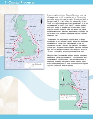
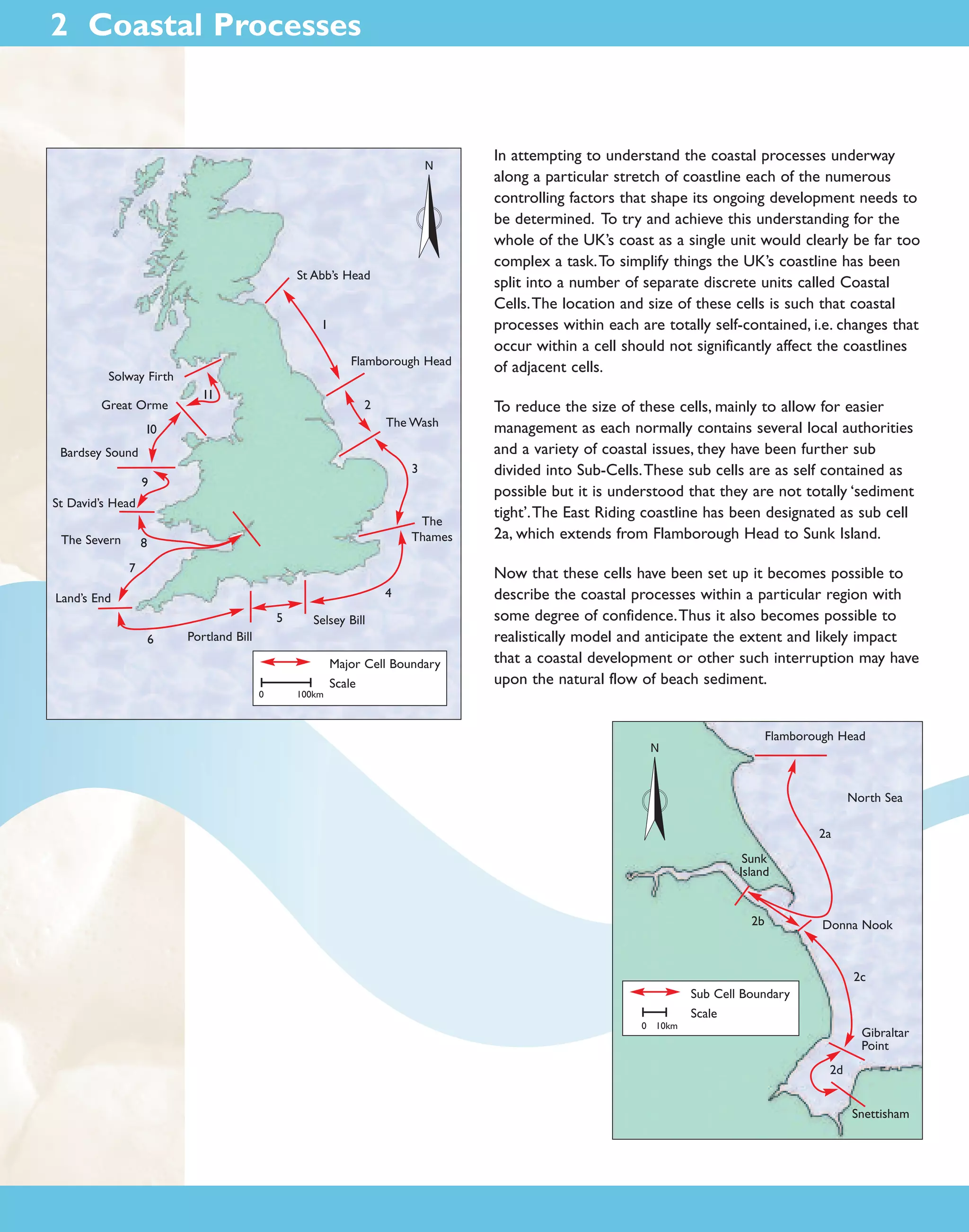
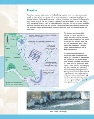
1) The UK coastline has been divided into coastal cells and sub-cells to simplify understanding coastal processes. The East Riding coastline is designated as sub-cell 2a.
2) Cliff erosion along the East Riding coast is complex and dynamic, driven by random wave and tidal forces. Erosion produces sediment that is sorted and transported south by these coastal processes. Beach levels fluctuate in response, impacting erosion rates.
3) Erosion occurs in four zones - the cliff face, nearshore beach, offshore clay face, and protected offshore seabed. Cliff erosion averages 1.7m/year while offshore erosion likely matches this rate, totaling around 3 million cubic meters of erosion
The Holderness Coastline in eastern England has some of the fastest erosion rates in Europe, averaging around 2 meters per year. The geology of the area, consisting of soft glacial till deposited over 12,000 years ago, is highly erodible and is being rapidly worn away by the sea. The village of Mappleton provides a case study of coastal management efforts, where rock groynes were constructed in 1991 to reduce erosion, but have shifted the erosion problem further south. Spurn Point at the southern end of the coastline consists of material deposited by longshore drift and acts as a barrier, though its position is now fixed through artificial defenses.
The Holderness Coast in Yorkshire, UK is one of Europe's fastest eroding coastlines, losing an average of 2 meters of land per year, which is around 2 million tons of material. It is composed of soft, erodible boulder clay deposited over glacial chalk bedrock. Resistant Flamborough Head chalk formations and deposition at Spurn Point evidence longshore drift along the coast. Landslips, rockfalls, and mudflows are coastal erosion processes affecting the less resistant boulder clay cliffs.
Holderness good overview including detailWill Williams
Here are the key coastal management schemes at Swanage and their purposes:
1. Groynes - To trap sediment moving along the shore by longshore drift, building up the beach in front of the groynes.
2. Sea wall - To act as a hard barrier protecting the town from wave attack and sea level rise.
3. Beach replenishment - To replace sediment lost from the beach through coastal processes, maintaining a wide beach as protection.
4. Planting marram grass - To stabilise sand dunes and prevent/slow blowouts, protecting the hinterland from flooding and erosion.
5. Offshore breakwaters - To reduce wave energy reaching the shore by causing waves to break
GEOGRAPHY IGCSE: THE HOLDERNESS COASTLINE. It contains: main facts, eroding coast Europe, long shore drift, features of the Holderness coastline, management, coastline defense.
The document discusses various coastal landforms created by erosion and deposition processes. It explains that waves break as they approach land due to increased friction. Swash carries water up the beach while backwash carries it down. Larger waves in the southwest are due to greater wind fetch. Cliffs and wave-cut platforms form through erosion processes like abrasion. Caves, arches, stacks and stumps also form through erosion. Beaches form in sheltered areas due to stronger swash depositing sediment. Spits and bars form through longshore drift depositing sediment. Tombolos connect landmasses.
GEOGRAPHY IGCSE: MANGROVE SWAMPS HABITAT. It contains: what are the mangroves, water salinity, mangrove swamps locations, environment benefits, why mangroves are good for us, social benefits of the mangroves, mangroves at risk, strategies to protect mangroves, mangroves in New Zealand.
A2 CAMBRIDGE GEOGRAPHY: COASTAL ENVIRONMENTS - WAVE, MARINE AND SUB-AERIAL PROCESSES. An overall presentation of the first sub-chapter of Coastal Environments chapter.
A2 Geography Revision for Coastal Environments, subchapter 8.4 Sustainable Management of Coasts. It is suitable for Year 13 Geography, Cambridge Examination in November 2016. It contains: key terms and definitions, a topic summary, sketches and descriptions, additional work (6 questions for testing your knowledge) and some suggested websites.
The Holderness Coastline of England suffers from the highest rates of coastal erosion in Europe due to its soft, easily eroded geology and exposure to strong winds and waves from the North Sea. Several villages have been lost to coastal erosion over the centuries. While some areas implement hard coastal defenses like seawalls and rock armor to combat erosion, these strategies are costly to maintain and can worsen erosion elsewhere down the coast. Integrated coastal zone management is now sought to balance protection of infrastructure with the natural shoreline processes.
The document discusses various methods for mitigating coastal erosion, including both hard and soft structural approaches. Hard structural methods discussed include jetties, seawalls, groins, revetments, and breakwaters. Soft structural approaches include beach nourishment and sand dune stabilization. Each method is described and their advantages and disadvantages are provided. In conclusion, coastal erosion affects the environment and communities require long-term strategies informed by science and engineering to control erosion.
Waves are the primary force causing erosion along coastlines. Constructive waves build beaches up while destructive waves erode beaches. Coastal landforms like cliffs, caves, arches and stacks are formed through erosion processes. Longshore drift transports sediment along the coast, potentially building up spits or bars. The coast at Holderness, East Yorkshire is eroding rapidly, retreating over 1 meter per year due to its soft cliff material and destructive North Sea waves. Several villages have been lost and infrastructure like roads and gas facilities are threatened. Various coastal defenses have been installed with mixed success.
This chapter discusses coastal processes and landforms. It describes how coastal zones are defined and influenced by waves, tides, currents, erosion and deposition. Some key coastal landforms include beaches, which are formed by sediment deposition, and coastal cliffs and sea stacks, which are formed by erosion. The chapter also categorizes different types of coastlines based on geological setting and sea level changes, and discusses islands and coral reefs.
The Holderness Coast in eastern England is eroding rapidly, losing an average of 2 meters per year to the North Sea. Over the past 6,000 years, more than 30 villages have been lost to coastal erosion as waves batter the soft boulder clay cliffs. The cliffs are prone to collapse as rainwater enters cracks and causes the clay material to slump down onto narrow beaches that offer little protection from wave energy due to longshore drift carrying away sediment. Various erosional processes such as wetting and drying of cliffs, storm waves attacking the shoreline, and longshore drift reducing beach size threaten the remaining villages along the Holderness Coast.
CAMBRIDGE AS GEOGRAPHY - CASE STUDY: ABERFAN MUDFLOWGeorge Dumitrache
(1) The document examines the 1966 mudflow disaster in Aberfan, Wales that was caused by the mismanagement of coal waste from nearby mines. (2) Over 100,000 cubic meters of saturated coal waste and debris engulfed parts of the village after heavy rainfall, including a local junior school where 116 children and 5 teachers were killed. (3) An official inquiry found the National Coal Board extremely negligent for irresponsibly dumping large amounts of coal waste on unstable hillsides near a populated area.
Earthquakes are caused by sudden movements within Earth's crust that cause rocks to bend, break or fracture. Most earthquakes occur along the Ring of Fire, a belt circling the Pacific Ocean where 88% of all quakes take place, and also along other belts where tectonic plates meet. Forces like tension, compression and shearing cause three types of rock fractures - normal faults where the rock moves apart, reverse faults where it moves together, and strike-slip faults where it slides horizontally past another part of the crust.
Beaches form in sheltered environments like bays through the processes of deposition. Spits are formed when longshore drift causes sediment to accumulate into narrow extensions of land along a shoreline. Bars are similar to spits but connect two areas of mainland, while tombolos connect an island to the mainland through a double-barred spit formation.
A case study on the Eyjafjallajökull Icelandic Eruption of 2010. Suitable for GCSE, AS Level, A Level Geography and beyond. Complete with stunning images.
Spits and bars are depositional coastal landforms formed by processes such as longshore drift. A spit is a depositional landform that extends from the shore out to sea, often curved in shape due to opposing winds and currents. A bar occurs where a spit grows across a bay, enclosing the bay to form a lagoon, or forms offshore due to breaking waves. Longshore drift transports sediment along the coast and causes deposition of material in certain areas, gradually building up spits and bars.
Ocean circulation is driven by two main forces - gravitation and solar radiation. Surface currents are influenced by global wind patterns and the Coriolis effect, forming large gyres in each ocean basin. Deep ocean circulation, called thermohaline circulation, is driven by differences in water density from temperature and salinity changes. It involves slow movement of deep water masses and accounts for 90% of ocean water movement. Major currents include the Gulf Stream and Antarctic Circumpolar Current.
This document describes different sedimentary environments including continental, marine, and transitional environments. Continental environments include fluvial (rivers), lacustrine (lakes), paludal (swamps), glacial, and desert. Rivers are subdivided into meandering and braided streams which form facies like point bars, oxbow lakes, levees, and crevasse splays. Transitional environments are where land and sea meet, and include deltas, tidal flats, beaches, barrier islands, and lagoons. Deltas in particular are divided into a delta plain, delta front, and prodelta.
The document discusses various topics related to ocean currents including:
1. Surface currents are driven by wind and heat distribution and form large gyre patterns in the oceans.
2. Deep ocean currents are driven by differences in water density from temperature and salinity and redistribute heat around the globe through thermohaline circulation.
3. Ocean currents influence climate by transporting warm and cold water to coastlines, affecting local and regional weather patterns.
This document discusses various coastal landforms and processes. It begins with defining terms related to waves and wave action. It then explains processes of marine erosion and how they can shape cliff coastlines and form wave-cut platforms. It describes how waves can transport and deposit sediment. Landforms like spits, bars, and salt marshes are discussed along with their formation. Finally, it covers coral reef types and theories about their formation, and how sea level changes can impact coral reefs.
Global sea levels are rising due to two main factors: eustatic change caused by melting ice sheets and glaciers which adds water to the oceans, and isostatic change where land masses rise or sink in response to being weighed down by ice. As sea levels rise, coastal landforms emerge like raised beaches and relict cliffs, while others submerge to form drowned river valleys called rias and flooded glacial valleys called fjords. Rising seas are predicted to flood low-lying coastal areas and increase erosion, threatening habitats, settlements, infrastructure and fresh water sources over the coming decades.
Mount Pinatubo, located in the Philippines, erupted in 1991 after a period of increased seismic activity. The eruption ejected ash up to 34km into the atmosphere, covering over 125,000km2 in ash and destroying 800km2 of agricultural land. Over 800,000 livestock were killed and 1.2 million people lost their homes. Pyroclastic flows and lahars (volcanic mudflows) caused additional damage. International aid and relocation efforts helped respond to the eruption, but lahars continued to impact the area for years. The hazard is now managed through monitoring, hazard maps, and building designs to mitigate future lahar impacts.
The document discusses coastal landforms and the processes that create them. It describes how waves, tides, and currents shape the coastal environment and lead to both erosional and depositional landforms. Erosional features include cliffs, headlands, sea caves, and stacks, which are formed by processes like abrasion and hydraulic action. Depositional landforms include beaches, bars, spits, and barrier islands, which are produced when sediment is transported and deposited by waves, currents, and biological activity.
Coastal processes and features by shirinShirin Bagchi
The document discusses coastal processes and landforms. It explains that coastal processes like tides, waves and currents constantly shape the coastline through erosion and deposition. This dynamic zone includes features like beaches, cliffs, caves and stacks that are formed by erosional forces, as well as spits, bars and tombolos created through deposition. Longshore drift plays a key role in shaping depositional landforms as sediments are transported along the shore. The profile of beaches and evolution of coastal dunes over time are also outlined.
Coastal erosion is the wearing away of land and removal of beach sediments by waves, currents, and drainage. Natural forces like wind, waves and currents shape coastal regions by moving land materials. Coastal erosion is the landward displacement of the shoreline caused by these forces. Factors influencing erosion include waves, currents, tides, wind, sand sources and sinks, sea level changes, coastal geomorphology, and human activities like construction and dredging. Coastal erosion can cause loss of land and property damage from landslides. Rates of erosion vary in different locations based on slope, wave intensity, wind, and shoreline characteristics.
This document discusses various types of coastal erosion and protection methods. It describes the characteristics and impacts of constructive and destructive waves. It also explains various coastal landforms that form from erosion like cliffs, arches and stacks. Additionally, it outlines different coastal management techniques like riprap, seawalls, beach replenishment and managed retreat. The advantages and disadvantages of each protection strategy are provided.
Coasts can be classified as primary or secondary based on tectonic position and sea level changes. Primary coasts are young and shaped by land-based processes, while secondary coasts are older and influenced by marine processes like waves, currents, and wind. Secondary coasts feature beaches, coastal landforms created by wave and current activity like barrier islands and cliffs, and depositional landforms like deltas formed at river mouths.
A spit is formed through the process of longshore drift. As waves approach the shore at an angle, sediment is carried along the coast until it reaches a change in direction, such as a headland. The sediment builds up over time to form a sandbar that stretches out into the sea. Spits continue growing until reaching an area of fast water flow or change in wind direction. Sheltered water and salt marshes form behind the spit, providing habitat for wildlife.
The document summarizes the formation and types of coastlines. It defines a coastline as the boundary where land meets the sea. Coastlines are formed through the erosion and deposition actions of waves, tides, currents and other marine processes on sediments and rocks. Major coastal landforms include beaches formed from sediment deposition, as well as erosional features like sea cliffs, wave-cut platforms, sea stacks and sea arches formed through wave erosion. Coastlines are classified based on their dominant formation processes into primary coastlines formed through terrestrial processes and secondary coastlines formed through marine erosion and deposition.
The document discusses coastal landforms and the processes involved in their formation. It covers both erosional and depositional coastal features. Erosional features like cliffs, arches and stacks are formed by processes like wave action, weathering and erosion concentrating on headlands. Depositional features such as beaches, spits and bars are produced by constructive waves depositing sediment transported by longshore drift. The key forces shaping the coast are waves, tides, currents and the underlying geology of the area.
The document summarizes coastal processes and features. It discusses how waves erode, transport, and deposit material, shaping coastlines. Coastal landforms like cliffs, headlands, bays, beaches, and sand dunes are formed through erosion or deposition. Coastal management considers both human uses of coasts and techniques to address physical processes like erosion.
presentation was provided by Prof W.U Chandrasekara
Department of Zoology and Environmental Management
For Coastal and Marine resource management course
This document discusses various coastal geological processes. It describes how coastal erosion occurs through hydraulic action, abrasion, attrition, and solution, forming features like wave-cut cliffs, platforms, sea caves, arches, and stacks. Coastal deposition happens when waves lose energy and drop sediment, forming features like spits, baymouth bars, sand bars, and barrier islands. Coastal inundation, or flooding, can result from storm surges, sea level rise, or tsunamis overtopping or breaching natural or man-made barriers. Coastal subsidence is also discussed, which is the sinking of coastal land caused by various geological processes.
Coastal erosion is the wearing away of land and the displacement of the shoreline caused by natural forces like waves, winds, and tides. It can also be exacerbated by human activities. The document outlines various natural causes of coastal erosion like wave action, winds, tides, storms, and sea level rise, as well as human causes like construction and dredging. Factors that influence erosion rates include sediment sources and sinks, changes in sea level, and coastal geomorphology. Coastal erosion shapes coastlines slowly over time but can also occur catastrophically during storms or tsunamis.
The document discusses various coastal processes and landforms. It describes the processes of swash and backwash that create different types of waves. It also discusses various erosional processes like hydraulic action, abrasion, and corrosion that lead to cliff recession. Coastal landforms like wave-cut platforms, headlands and bays, stacks and stumps are formed through these erosional processes. Coastal management techniques like groynes, sea walls, and beach replenishment are used to reduce coastal erosion.
Coastal erosion is the wearing away of land and removal of beach sediments by wave action, tidal currents, and other processes. Coasts are classified as primary, shaped by land erosion, or secondary, shaped by marine agents. Erosional coasts experience active erosion while depositional coasts experience sediment accumulation from rivers or oceans. Waves, tides, currents, and coastal dynamics shape shorelines through erosion, transportation, and deposition, forming landforms like sea stacks, arches, caves, spits, barrier islands, and deltas. The rate of coastal destruction varies depending on slope, wave intensity, wind, and human activities and can damage habitats.
This document discusses various coastal landforms and erosion processes. It describes how discordant and concordant coastlines form different landforms like headlands and bays. It explains the formation of cliffs, wave cut platforms, caves, arches, stacks and stumps through coastal erosion processes. It also discusses coastal transportation by longshore drift and how this builds up features like spits, bars and beaches through deposition. Coastal management techniques are mentioned like using groynes to reduce erosion.
A2 Geography Revision for Coastal Environments, subchapter 8.2 Coastal Landforms of Cliffed and Constructive Coasts. It is suitable for Year 13 Geography, Cambridge Examination in November 2016. It contains: key terms and definitions, a topic summary, sketches and descriptions, additional work (6 questions for testing your knowledge) and some suggested websites.
GEOGRAPHY YEAR 10: COASTAL LANDFORMS. It contains: coastal landforms, depositional landforms, beaches, attrition, spits, longshore drift, tombolos, cliffs, the procesa of cliff erosion, headlands and bays, caves, arches, stacks and stumps.
The document discusses various coastal landforms created by wave erosion and deposition along shorelines. It describes how alternating bands of hard and soft rock lead to the formation of headlands and bays through differential erosion. As waves erode the soft rock faster than the hard rock, an irregular coastline develops. Further erosion can form caves, arches, stacks, and stumps. Coves are formed when a stream cuts through a cliff, widening through erosion. Wave-cut platforms are flat terraces exposed when cliffs retreat inland. Longshore drift can build up spits, narrow accumulations of sand and gravel stretching from the shore into the sea.
The coast is a narrow contact zone between land and sea that is constantly changing due to various land, air, and marine processes. Waves are a major force shaping the coastline, with characteristics like height, period, length, and steepness influencing their constructive or destructive power. Coastal landforms like beaches, sand dunes, spits, bars, cliffs, and caves form through the interacting processes of erosion, sediment transport, and deposition that waves and currents bring about.
Similar to Coastal Processes on the Holderness Coast (20)
The document describes the journey of the River Tees from its source in the Pennines to its mouth in the North Sea. It discusses the landforms and processes along the upper, middle, and lower courses of the river. In the upper course, erosion is the main process and landforms include High Force waterfall and gorge formed by the erosion of softer rock from under hard cap rock. Meanders, ox-bow lakes, and levées are formed in the middle to lower courses as erosion gives way to deposition. The river's estuary at its mouth was formed by rising sea levels after the Ice Age.
Here are the key periglacial processes likely occurring around the glacier shown in Figure 2:
- Frost shattering of rock producing scree slopes at the base of valley sides due to repeated freezing and thawing.
- Solifluction occurring on valley sides within the active layer, transporting fine material downslope and leaving lobes and terraces.
- Nivation occurring in hollows beneath snowpatches on north-facing slopes, deepening the hollows through frost action and meltwater erosion.
- Patterned ground such as stone stripes forming in better drained areas subjected to freeze-thaw cycles.
- Fluvial erosion by meltwater streams flowing from the glacier, causing erosion and leaving braided
Here is a 4 mark labelled sketch of an esker:
[SKETCH OF AN ESKER]:
- Sinuous ridge
- Coarse gravel and sand
- Stratified layers
- 5-20m high
Eskers form through the process of subglacial deposition:
Meltwater flows through tunnels beneath the glacier. As it flows, it deposits material in the tunnel. Coarser material is deposited first, creating layers. As the glacier melts away, it leaves behind the sinuous ridge of stratified sand and gravel - the esker. The tunnel walls confined the meltwater flow and pressure, allowing transport and deposition of material.
This document discusses different types of glacial landforms formed by the deposition of debris (moraine) transported and deposited by glaciers. It describes erratics as large rocks transported far from their source, moraines as ridges of glacial debris including terminal, lateral, and recessional moraines, and drumlins as streamlined hills that indicate the direction of past ice flow. Drumlins are proposed to form through subglacial deformation as the glacier becomes overloaded with debris and moulds it into characteristic elongated shapes aligned with ice movement.
The document lists various topics related to artworks and locations including Constable painting a ploughing scene in Suffolk, Aboriginal art and maps of Australia, the Lake District region, haymaking on the Thames river, New York City, JMW Turner's paintings of the Lake District, Wordsworth, rural Wales, and advertisements.
Weathering is the breaking down of rocks in place due to exposure to weather and other environmental factors like temperature changes, water, plant roots, and human activity. Erosion is a broader term that includes both the breakdown and removal of rocks by forces like moving ice sheets or flowing water. When looking at landforms like valleys, you can see evidence of both weathering, which created smaller rock fragments, and erosion, which transported material away, leaving the characteristic valley shape.
During ice ages, large parts of northern Europe including Scotland were covered in deep ice. Sea levels were lower because less water flowed into oceans as snow and ice built up on land. The last major cold period was the Pleistocene Ice Age, which started 1.8 million years ago and ended around 10,000 years ago. Natural causes of climate change include variations in Earth's orbit and axis, volcanic eruptions, and changes in solar activity, which can cause the climate to become colder or warmer over both short and long time scales.
A glacier forms over many years in places where snow falls but does not melt, accumulating in layers that compress into ice. As glaciers move into warmer areas, melting occurs at the glacier's snout or front. Glaciers advance when accumulation exceeds melting and retreat when melting exceeds accumulation. Factors influencing this balance include climate cycles, volcanic eruptions, and human-caused global warming, which is currently causing many glaciers to retreat rapidly.
The document discusses flood management of the River Tees in England. It describes how the river's basin and flow patterns make it prone to flash flooding. It has been managed through various methods: reservoirs were built starting in the late 19th century to control water levels and flooding. More recently, a barrage was constructed to reduce tidal flooding while improving the environment and recreation. Flood plain zoning and defending towns like Yarm also aim to reduce flooding impacts while allowing natural floods. Combined, these strategies provide water resources while mitigating risks from the river's variable flow.
WaterAid in Mali's 2010-2015 Country Strategy aims to support over 415,000 vulnerable people in 23 local governments to gain access to safe water and adequate sanitation. The strategy focuses on new approaches like Community Led Total Sanitation, equity and inclusion, local governance, and water resource management. It also aims to strengthen sector capacity, promote sector policies, and integrate water and sanitation into other sectors like health and education. WaterAid will work with local partners and governments to implement projects targeting the most marginalized communities and track progress through strengthened monitoring and evaluation.
The document is a summary of the East Cornwall Catchment Flood Management Plan (CFMP). It describes the flood risks in the area and sets out policies and actions to manage those risks over the next century. The CFMP divides the catchment into areas with similar flood risk characteristics called policy units. For each unit it identifies one of six policies to reduce, accept, or take advantage of flood risk. The actions proposed include flood storage schemes, maintaining existing flood defenses, surface water management plans, and working with landowners to reduce runoff. The goal is to implement the policies through cooperation with local authorities and other groups.
Heavy rainfall in August 2004 caused flash flooding in the village of Boscastle in Cornwall, damaging homes and businesses. The physical causes were intense rainfall over a short period which the small rivers could not cope with, exacerbated by steep slopes and saturated ground. Human factors included development in a narrow floodplain and an increased summer population. The effects included economic losses, property damage, infrastructure disruption and mental trauma for residents from the devastation. While Boscastle has always been at flood risk, some experts believe climate change may be increasing the potential for extreme storms.
The document provides a timeline of events during the Boscastle flood of August 2004 in Cornwall, UK. Over the course of a few hours, intense rainfall caused severe flooding that trapped many people in buildings. Emergency services launched a major rescue operation that involved helicopters airlifting over 150 people to safety. The flooding caused widespread damage, but there were no reported casualties. Lessons were learned about having plans and resources in place to respond quickly and safely to changing conditions during major flooding events.
This document summarizes a history of flash flooding events in Boscastle, Cornwall and surrounding areas in the UK dating back to the 18th century. It notes several major flooding events that caused significant damage, including in 1827, 1847, 1952 and most recently in 2004 when over 1,000 residents and visitors were affected in Boscastle. The 2004 flooding was described as the largest peacetime rescue in British history, with 58 properties flooded and thousands of pounds needed for infrastructure repairs. While views on climate change conflict, the document acknowledges climate is changing and instances of severe storms and floods are expected to increase.
1) Climate observations in the UK show warming since 1960, with greater warming in summer than winter. There have also been increases in warm days/nights and decreases in cool days/nights. Human influence has increased the likelihood of warm summers.
2) Climate projections for the UK show temperature increases of up to 3C in the south and 2.5C further north by 2100 under a mid-range emissions scenario. Precipitation is projected to increase up to 10% across most of the UK, though some southern areas could see decreases of up to 5%.
3) Climate impacts projections include the potential for declining crop yields in southern UK but increases in northern areas. The UK is expected to
This document provides an overview of coastal processes and landforms along the Humberside and Lincolnshire coastline in the UK. It describes how the coastline has changed over time, from the last ice age until present day, noting that rising sea levels flooded the area around 6000 years ago and created new coastal landforms like Holderness. The coastline consists of interconnected coastal areas from Flamborough Head to Gibraltar Point that function as a single coastal system influenced by tidal flows, waves, and sediment movement. Future sea level rise poses risks to the coastline from increased flooding and erosion. The document aims to provide context to help coastal managers make informed decisions that work with natural coastal processes.
Urban climates differ from rural climates due to factors like increased surface area from buildings absorbing heat, lack of vegetation and evapotranspiration, and additional heat from human activities. This can lead to urban heat islands where temperatures are warmer in cities. While some effects are negative like increased heat stress, others are positive like reduced energy demands. Urban climatologists first systematically studied these effects in the 19th century, and interest has grown with increasing urbanization globally. Mitigation strategies aim to reduce heat absorption and increase shading and evaporation to minimize urban warming.
Robert Wilby examines the urban heat island effect and air quality in London, UK. London's central areas can be several degrees warmer than surrounding rural areas due to increased surface and air temperatures from urban development (the heat island effect). This effect is most pronounced at night and under light wind conditions. While air pollution levels have declined overall in the UK since the 1990s, some parts of London still exceed air quality standards, especially for nitrogen dioxide and particulate levels from vehicle emissions. Future projections estimate more frequent and severe heat waves could increase heat-related mortality, and changes in wind patterns may shift the location of the peak heat island effect within London.
The document discusses microclimates, specifically focusing on upland regions, coastal regions, and forests. It provides details on how factors like elevation, proximity to bodies of water, and vegetation influence temperature, precipitation, wind, and other climate variables at small, localized scales compared to broader regional climates. Examples are given comparing the climates of locations in Devon, England to illustrate temperature, rainfall, and sunshine differences between an upland site and two coastal sites only 20 miles apart.
GDG Cloud Southlake #33: Boule & Rebala: Effective AppSec in SDLC using Deplo...James Anderson
Effective Application Security in Software Delivery lifecycle using Deployment Firewall and DBOM
The modern software delivery process (or the CI/CD process) includes many tools, distributed teams, open-source code, and cloud platforms. Constant focus on speed to release software to market, along with the traditional slow and manual security checks has caused gaps in continuous security as an important piece in the software supply chain. Today organizations feel more susceptible to external and internal cyber threats due to the vast attack surface in their applications supply chain and the lack of end-to-end governance and risk management.
The software team must secure its software delivery process to avoid vulnerability and security breaches. This needs to be achieved with existing tool chains and without extensive rework of the delivery processes. This talk will present strategies and techniques for providing visibility into the true risk of the existing vulnerabilities, preventing the introduction of security issues in the software, resolving vulnerabilities in production environments quickly, and capturing the deployment bill of materials (DBOM).
Speakers:
Bob Boule
Robert Boule is a technology enthusiast with PASSION for technology and making things work along with a knack for helping others understand how things work. He comes with around 20 years of solution engineering experience in application security, software continuous delivery, and SaaS platforms. He is known for his dynamic presentations in CI/CD and application security integrated in software delivery lifecycle.
Gopinath Rebala
Gopinath Rebala is the CTO of OpsMx, where he has overall responsibility for the machine learning and data processing architectures for Secure Software Delivery. Gopi also has a strong connection with our customers, leading design and architecture for strategic implementations. Gopi is a frequent speaker and well-known leader in continuous delivery and integrating security into software delivery.
Removing Uninteresting Bytes in Software FuzzingAftab Hussain
Imagine a world where software fuzzing, the process of mutating bytes in test seeds to uncover hidden and erroneous program behaviors, becomes faster and more effective. A lot depends on the initial seeds, which can significantly dictate the trajectory of a fuzzing campaign, particularly in terms of how long it takes to uncover interesting behaviour in your code. We introduce DIAR, a technique designed to speedup fuzzing campaigns by pinpointing and eliminating those uninteresting bytes in the seeds. Picture this: instead of wasting valuable resources on meaningless mutations in large, bloated seeds, DIAR removes the unnecessary bytes, streamlining the entire process.
In this work, we equipped AFL, a popular fuzzer, with DIAR and examined two critical Linux libraries -- Libxml's xmllint, a tool for parsing xml documents, and Binutil's readelf, an essential debugging and security analysis command-line tool used to display detailed information about ELF (Executable and Linkable Format). Our preliminary results show that AFL+DIAR does not only discover new paths more quickly but also achieves higher coverage overall. This work thus showcases how starting with lean and optimized seeds can lead to faster, more comprehensive fuzzing campaigns -- and DIAR helps you find such seeds.
- These are slides of the talk given at IEEE International Conference on Software Testing Verification and Validation Workshop, ICSTW 2022.
GridMate - End to end testing is a critical piece to ensure quality and avoid...ThomasParaiso2
End to end testing is a critical piece to ensure quality and avoid regressions. In this session, we share our journey building an E2E testing pipeline for GridMate components (LWC and Aura) using Cypress, JSForce, FakerJS…
A tale of scale & speed: How the US Navy is enabling software delivery from l...sonjaschweigert1
Rapid and secure feature delivery is a goal across every application team and every branch of the DoD. The Navy’s DevSecOps platform, Party Barge, has achieved:
- Reduction in onboarding time from 5 weeks to 1 day
- Improved developer experience and productivity through actionable findings and reduction of false positives
- Maintenance of superior security standards and inherent policy enforcement with Authorization to Operate (ATO)
Development teams can ship efficiently and ensure applications are cyber ready for Navy Authorizing Officials (AOs). In this webinar, Sigma Defense and Anchore will give attendees a look behind the scenes and demo secure pipeline automation and security artifacts that speed up application ATO and time to production.
We will cover:
- How to remove silos in DevSecOps
- How to build efficient development pipeline roles and component templates
- How to deliver security artifacts that matter for ATO’s (SBOMs, vulnerability reports, and policy evidence)
- How to streamline operations with automated policy checks on container images
Securing your Kubernetes cluster_ a step-by-step guide to success !KatiaHIMEUR1
Today, after several years of existence, an extremely active community and an ultra-dynamic ecosystem, Kubernetes has established itself as the de facto standard in container orchestration. Thanks to a wide range of managed services, it has never been so easy to set up a ready-to-use Kubernetes cluster.
However, this ease of use means that the subject of security in Kubernetes is often left for later, or even neglected. This exposes companies to significant risks.
In this talk, I'll show you step-by-step how to secure your Kubernetes cluster for greater peace of mind and reliability.
Goodbye Windows 11: Make Way for Nitrux Linux 3.5.0!SOFTTECHHUB
As the digital landscape continually evolves, operating systems play a critical role in shaping user experiences and productivity. The launch of Nitrux Linux 3.5.0 marks a significant milestone, offering a robust alternative to traditional systems such as Windows 11. This article delves into the essence of Nitrux Linux 3.5.0, exploring its unique features, advantages, and how it stands as a compelling choice for both casual users and tech enthusiasts.
Why You Should Replace Windows 11 with Nitrux Linux 3.5.0 for enhanced perfor...SOFTTECHHUB
The choice of an operating system plays a pivotal role in shaping our computing experience. For decades, Microsoft's Windows has dominated the market, offering a familiar and widely adopted platform for personal and professional use. However, as technological advancements continue to push the boundaries of innovation, alternative operating systems have emerged, challenging the status quo and offering users a fresh perspective on computing.
One such alternative that has garnered significant attention and acclaim is Nitrux Linux 3.5.0, a sleek, powerful, and user-friendly Linux distribution that promises to redefine the way we interact with our devices. With its focus on performance, security, and customization, Nitrux Linux presents a compelling case for those seeking to break free from the constraints of proprietary software and embrace the freedom and flexibility of open-source computing.
Threats to mobile devices are more prevalent and increasing in scope and complexity. Users of mobile devices desire to take full advantage of the features
available on those devices, but many of the features provide convenience and capability but sacrifice security. This best practices guide outlines steps the users can take to better protect personal devices and information.
UiPath Test Automation using UiPath Test Suite series, part 5DianaGray10
Welcome to UiPath Test Automation using UiPath Test Suite series part 5. In this session, we will cover CI/CD with devops.
Topics covered:
CI/CD with in UiPath
End-to-end overview of CI/CD pipeline with Azure devops
Speaker:
Lyndsey Byblow, Test Suite Sales Engineer @ UiPath, Inc.
Alt. GDG Cloud Southlake #33: Boule & Rebala: Effective AppSec in SDLC using ...James Anderson
Effective Application Security in Software Delivery lifecycle using Deployment Firewall and DBOM
The modern software delivery process (or the CI/CD process) includes many tools, distributed teams, open-source code, and cloud platforms. Constant focus on speed to release software to market, along with the traditional slow and manual security checks has caused gaps in continuous security as an important piece in the software supply chain. Today organizations feel more susceptible to external and internal cyber threats due to the vast attack surface in their applications supply chain and the lack of end-to-end governance and risk management.
The software team must secure its software delivery process to avoid vulnerability and security breaches. This needs to be achieved with existing tool chains and without extensive rework of the delivery processes. This talk will present strategies and techniques for providing visibility into the true risk of the existing vulnerabilities, preventing the introduction of security issues in the software, resolving vulnerabilities in production environments quickly, and capturing the deployment bill of materials (DBOM).
Speakers:
Bob Boule
Robert Boule is a technology enthusiast with PASSION for technology and making things work along with a knack for helping others understand how things work. He comes with around 20 years of solution engineering experience in application security, software continuous delivery, and SaaS platforms. He is known for his dynamic presentations in CI/CD and application security integrated in software delivery lifecycle.
Gopinath Rebala
Gopinath Rebala is the CTO of OpsMx, where he has overall responsibility for the machine learning and data processing architectures for Secure Software Delivery. Gopi also has a strong connection with our customers, leading design and architecture for strategic implementations. Gopi is a frequent speaker and well-known leader in continuous delivery and integrating security into software delivery.
Unlocking Productivity: Leveraging the Potential of Copilot in Microsoft 365, a presentation by Christoforos Vlachos, Senior Solutions Manager – Modern Workplace, Uni Systems
1. 2 Coastal Processes
N
St Abb’s Head
1
Flamborough Head
Solway Firth
Great Orme
11
2
The Wash
10
Bardsey Sound
3
9
St David’s Head
The Severn
The
Thames
8
7
4
Land’s End
5
6
Selsey Bill
Portland Bill
0
100km
Major Cell Boundary
Scale
In attempting to understand the coastal processes underway
along a particular stretch of coastline each of the numerous
controlling factors that shape its ongoing development needs to
be determined. To try and achieve this understanding for the
whole of the UK’s coast as a single unit would clearly be far too
complex a task.To simplify things the UK’s coastline has been
split into a number of separate discrete units called Coastal
Cells.The location and size of these cells is such that coastal
processes within each are totally self-contained, i.e. changes that
occur within a cell should not significantly affect the coastlines
of adjacent cells.
To reduce the size of these cells, mainly to allow for easier
management as each normally contains several local authorities
and a variety of coastal issues, they have been further sub
divided into Sub-Cells.These sub cells are as self contained as
possible but it is understood that they are not totally ‘sediment
tight’.The East Riding coastline has been designated as sub cell
2a, which extends from Flamborough Head to Sunk Island.
Now that these cells have been set up it becomes possible to
describe the coastal processes within a particular region with
some degree of confidence.Thus it also becomes possible to
realistically model and anticipate the extent and likely impact
that a coastal development or other such interruption may have
upon the natural flow of beach sediment.
Flamborough Head
N
North Sea
2a
Sunk
Island
2b
Donna Nook
2c
Sub Cell Boundary
Scale
0 10km
Gibraltar
Point
2d
Snettisham
2. Erosion
As we have seen the rapid erosion of the East Riding coastline is not a new phenomenon, the
people of this area have had to deal with its consequences since early settlements began to
develop following the ice age. Documentary evidence records the loss of up to 14 villages so far
since Roman times, all that now remains is a legacy of road names leading to long lost villages.
With such a long history it might be expected that the processes that lead to erosion would be
well understood, this is not the case however. Numerous studies have attempted to determine
the causes and suggest solutions to this erosion problem but as yet no conclusive answer has
been found.
Clockwise rotation in flood tide around Flamborough
Head creates northerly flow
N
Flamborough Head
Bridlington
Smithic Sands and Flamborough Head reduce local
wave activity and realign wave front
Barmston
Driffield
Pre
fro domin
mt
he ant w
nor ave
th e s
ast
Hornsea
Beverley
Kingston
Upon Hull
Falling ebb tide
producing north
westerly currents of up
to 0.25m/s
Mappleton
Advancing flood tide
producing south easterly
currents of up to 0.5m/s
Tunstall
Withernsea
The Binks glacial ridge
reduces wave activity
around Spurn Point
Easington
River
Humber
Net tide current direction
Net wave transport direction
This situation is understandable
however as it turns out that the
coastal processes that lead to erosion
are far more complex than may appear
at first sight.The difficulty lies in the
fact that cliff recession is not a static
measurable quantity but a dynamic
system driven by a random mix of
wave and tidal forces.
To complicate things further the
erosion that these forces generate is
then in turn controlled by the sediment
that it produces.This second system
relies upon the formation and retention
of a stable beach as in absorbing wave
energy a beach protects the underlying
clay strata and cliffs, thus preventing
erosion. Ironically reducing erosion in
this way slows down the production of
sand, which then reduces beach levels
leading to increased erosion.Thus cliff
erosion is ultimately driven by storm
seas and is governed by the cycle of
beach growth and loss.
Spurn Point
North Landing, Flamborough
3. If beach sand could be contained through
effective beach control systems such as a
groyne field or the development of a
stable bay, cliff erosion would locally stop.
Beach levels however tend to fluctuate
due to interruptions in the southerly
supply of beach sand or following storms
that temporarily draw sand offshore. If
this lowering of beach levels leads to
exposure of the underlying clay surfaces
then irreversible erosion will occur.
Flamborough Head
Bridlington
Storms may drive up to 40,000m^3 of sand south around Flamborough.
Smithic Sands - offshore sand banks deposited in
lee of cliffs store and regulate supply of sand.
Wave and tidal forces lead to erosion of clay cliffs and bed strata, this eroded
material is then transported southwards by wave and tidal forces.
Driffield
Wave action moves sand in net southerly direction .
Muds and clays in suspention move south and offshore.
Larger cobbles and rock remain and collect offshore.
Hornsea
Beverley
Since cliff erosion is tied to so many
unpredictable quantities accurate
prediction of future erosion is
impossible.The only means available to
forecast erosion is through analysis of
historical records. If coastal processes
remain unchanged then it can be
assumed that past and future erosion
rates at each location will remain fairly
similar. So to foretell erosion it is first
necessary to establish past erosion.The
East Riding of Yorkshire began this
exercise in 1951 and has since built up
an extensive record of historical erosion
data for the entire East Riding coastline.
This erosion record is now updated
every six months, and is becoming more
accurate as the data set increases.
Small quantities of sand transported north by net northerly tide
cycle, possibly balancing that driven southwards.
N
Cliff erosion rates of up to 1.8m/yr liberate up to 1 million
m^3 of sediment. Erosion of the clay foreshore produces up
to a further 2 million m^3 therefore annual sediment
production can be up to 3 million m^3.
Mappleton
Total sediment quantities
Sediment Gradings
% of Total
Clays <64m^–6
79%
Fine Sands <128m^–6
12.5%
Sands Shingle >128m^–6 4.5%
Cobbles Boulders >0.15m 1%
Tunstall
Kingston
Upon Hull
Quantity m^3/year
2,370,000
375,000
225,000
30,000
Withernsea
Easington
River
Humber
Spurn
Point
Direction of net sand flow
Direction of net mud flow
Long term control of erosion would require permanent protection of the cliff and foreshore
clays. Simply defending the cliff toe through construction of a seawall or other such defence
would still allow the foreshore to erode, ultimately undermining the structure. Maintaining a
beach through effective sand control is therefore the aim when defending a frontage, the beach
itself also provides a valuable amenity asset. Once established a beach can be contained through
construction of a groyne field, the physical barrier that these structures provide prevents sand
moving along and past the frontage. Storms can still draw sand directly seaward so beach sand is
still lost and foreshore erosion does occur but at a much reduced rate.
Defending a frontage through the construction of a beach control system can however lead to
problems immediately down-drift, as following their construction these structures promote the
retention of sand which then reduces the supply down-drift. However this initial response is
relatively short term as once the defences are filled, sand will overtop and bypass them, leading
to the restoration of the drift system. In the longer term cyclic reductions in defended beach
levels will recreate the post construction conditions as the defences attempt to restore sand
levels, also in raising foreshore sand levels sand movement will tend to move offshore, the net
effect is a destabilising of down drift sand supply.
Sediments move offshore or
continue on to the Humber
estuary then to beaches
southwards
4. Mechanics of Cliff Erosion
Beach levels fluctuate constantly in response to changing sediment supplies and sea conditions,
however these changes in beach profile only become permanent following erosion of the
underlying clay substrate as once lost this material cannot be regained. Erosion of these clay
surfaces occurs whenever they are exposed either to the direct shearing force of moving water
or the abrasive action of moving sand. Either way erosion only occurs when wave or tidal forces
are of sufficient strength to transport sediments. In the near-shore zone waves which strike the
beach at an angle dominate whereas in deeper water tidal currents take over, both producing a
net southerly drift.
Wa
ve
bea s pu
ch sh s
at
an and u
ang p
le
Wa
ves
s
at a trike
n a bea
ngl
e ch
nt
me
ve
mo
rly
the d
ou san
t s ch
Ne bea
of
Gravity draws water
and sand back
perpendicular to beach
Movement of beach sand due to wave action
Beach sediments found along the East Riding coastline
are derived from erosion of the cliffs and foreshore.
This glacial till material is mainly composed of clays but
it also contains a mixture of fine to course sands and a
small amount of larger cobbles and rocks.
Once released by the sea these sediments are first
sorted and then transported away by wave and tidal
forces. Fine clays and muds that form the bulk of this
material are put into suspension then rapidly carried
south and offshore, most ending up within the Humber
Estuary. Sands move more slowly southwards mainly
under wave action and remain within the near-shore
zone, forming the beaches that can be seen at the base
of the cliffs. Larger cobbles and rocks tend to be drawn
offshore where they remain and gather, as in deeper
water waves are no longer capable of moving them.
Over time a blanket of such material develops, helping
to protect the underlying clay.
5. Clay Erosion
Of the four distinct zones identified on the profiles overleaf
erosion of clay surface can be seen to be occurring in three of
them:-
Zone 1 - The cliff face:
The most visible of the erosion zones, the cliff face undergoes
erosion whenever the tide is high enough to allow wave action
to strike its base.Wave impact and abrasion forces are then
capable of removing material so steepening the cliff face to a
point where it collapses spilling material onto the beach, this
clay is then rapidly removed by subsequent tides. If beach levels
are particularly low then a higher number of tides will reach the
cliffs and more erosion will occur.This erosion state will usually
continue until beach levels recover, which can be anything from
months to several years. A period of relative calm will then
follow until the cycle repeats again which may be in years or even decades time.
As unpredictable beach levels play such an important roll in controlling cliff erosion rates there
is considerable variation in erosion over time and at each location. Opposite stable managed
frontages erosion has been reduced to near zero, whereas on exposed stretches erosion rates
have on occasion been consistently recorded at over a metre a month. The average rate
however for the Holderness area south of Atwick has in the long term been fairly consistent at
just over 1.7m/year.
Tunstall
Cowden
6. Zone 2
Zone 3
Variable thickness
mobile sand layer
0 to about 4 metres 0 to about 5 centimetres
deep on upper beach
deep offshore
Incoming waves drive sand
inshore and southward
Zone 4
Offshore clay face
Eroding cliff face
Zone 1
Cobble/Rock layer
Incoming waves gather
and hold rock inshore
TYPICAL BEACH PROFILE
Level in metres above ODN
Cliff erosion
1 to 2m/yr
Slow vertical erosion of about 2 to 4cm/yr
No erosion
Clay face probably eroding to
keep pace with cliffs
Approx. distance offshore of cliff in metres
Level in metres above ODN
TYPICAL CLAY EROSION RATES
Summer calm weather builds sand on
upper beach
Winter’s rough seas pull sand down beach
to offshore sand banks
Approx. distance offshore of cliff in metres
CHANGES IN BEACH PROFILE IN RESPONSE TO CHANGING CONDITIONS
7. Zone 2 - The near-shore zone:
Fronting the cliffs and covering the underlying clay is a wave driven highly mobile layer of sand
and shingle, that can be anything from several metres deep to entirely absent, depending upon
sediment supply and wave conditions. As erosion of the clay only happens when it is exposed to
wave and tidal forces the depth and profile of this beach determines where and when erosion
can occur.
Normally a typical beach will develop and dissipate on a steady
cycle lasting several years as littoral transport drives waves of
sand southwards, this allows intermittent but steady erosion of
the foreshore. Storm conditions can however cause rapid
changes in beach profile by drawing sand offshore, possibly
stripping a beach of all its sand in a single tide. During this time
continued rough seas can cause rapid erosion of the newly
exposed clay. Recovery from such an event can then take
several months as calmer seas return sand to the upper beach.
As can be seen opposite these changes in beach profile can be
seen as a seasonal beach response, this accounts for the
increased erosion rates recorded over the winter months.
Further offshore in deeper water wave forces reduce in power
so the sand layer tends to be more stable, however it is often
only a few centimetres thick. Erosion over this area occurs as a
result of the steady movement of this thin sand layer as it leads
to abrasion of the under lying clay surface.
Few measurements have been taken of the long-term erosion
rate of this clay strata however it can be assumed that since the
overall profile remains fairly constant then erosion of the
foreshore matches cliff erosion rates.This gives an erosion rate
lowering of between 2 to 4 centimetres per year.
Skipsea
Zone 3 - The offshore clay face:
A feature of the Holderness coastline that has been observed along most of its length during
hydro-graphic seabed surveys is the presence of an offshore submerged clay cliff face that can be
up to several metres high. It has been suggested that this cliff may be a fossil cliff line dating to
the early Holocene times.
This cliff forms the boundary between the eroding inshore zone and the stable offshore seabed.
Due to its inaccessibility few if any measurements of the erosion of this face have been made.
Evidence suggests however that it is eroding at approximately the same rate of retreat as the
main cliff line i.e. approximately 1.7m/year.
8. Zone 4 - The offshore seabed:
Offshore of these eroding surfaces the seabed is protected by a thin rocky layer formed by the
collecting together through onshore wave forces, of larger eroded materials. In isolation waves
are able to move quite large obstacles however when grouped together they act as one and
become immobile. Over time the thickening of this layer will provide protection to the
underlying clay preventing any further lowering.Thus the depth, location and likely-hood of the
formation of this layer depends upon the quantity and size of rock contained within the original
clay body.
The total erosion volume is therefore the sum of these onshore and offshore volumes. Erosion
of the cliff is readily measurable and has been calculated to be just under one million metres
cubed per year. Estimates for the unseen offshore erosion vary but suggest a volume of twice
that of the cliff erosion, giving a total of approximately 3 million metres cubed per year.
North Landing, Flamborough