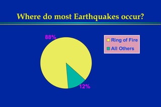
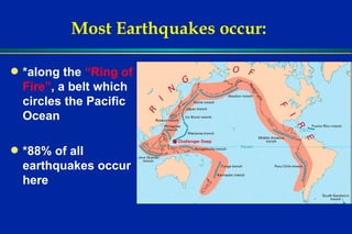
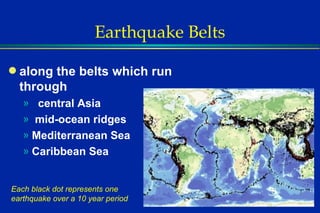
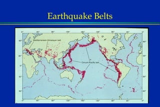
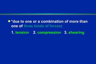
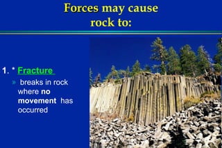
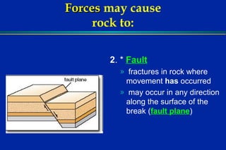
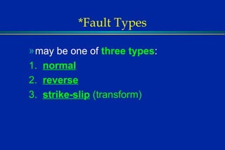
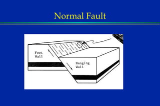
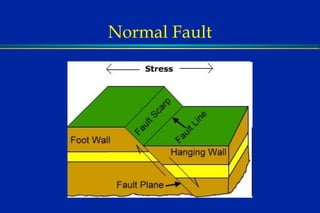
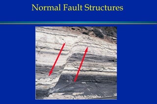
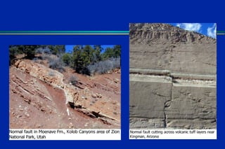
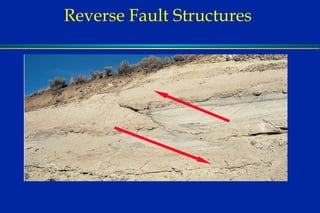
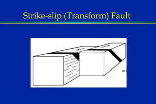
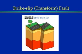
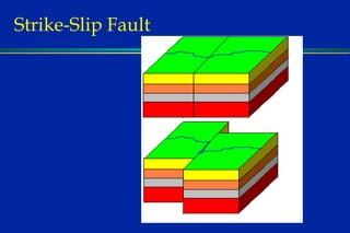
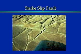
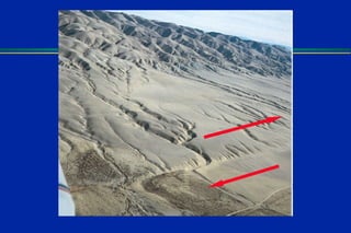
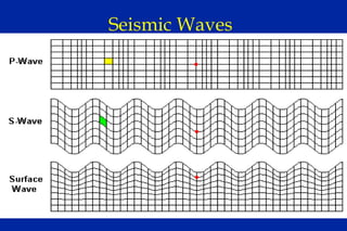
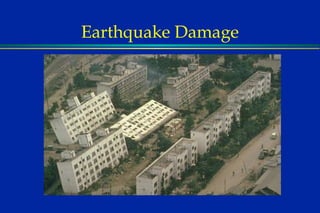
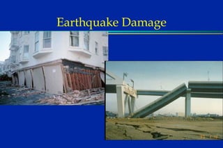
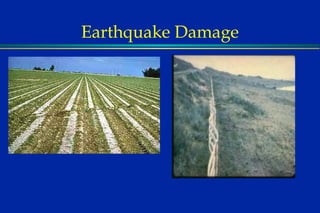
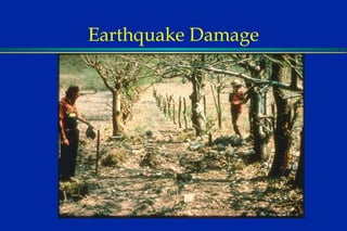
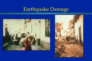
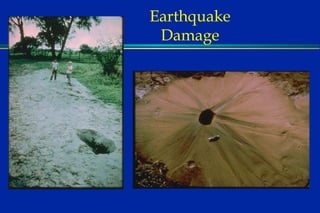
Earthquakes are the  vibrations  caused by sudden movements of Earth’s rocks.  Forces  within the crust cause rocks to  bend  or   break .
Where do most Earthquakes occur?
Most Earthquakes occur: *along the  “Ring of Fire” , a belt which circles the Pacific Ocean *88% of all earthquakes occur here
Earthquake Belts along the belts which run through central Asia mid-ocean ridges Mediterranean Sea Caribbean Sea Each black dot represents one earthquake over a 10 year period
Earthquake Belts
*due to one or a combination of more than one of  three kinds of forces : 1.  tension   2.  compression   3.  shearing
Elastic Rebound
Forces   may cause rock to: 1 . *  Fracture  breaks in rock where  no movement   has occurred
 
Forces   may cause rock to: 2 . *  Fault   fractures in rock where movement  has  occurred may occur in any direction along the surface of the break ( fault plane )
*Fault Types may be one of  three types : 1.  normal 2.  reverse 3.  strike-slip  (transform)
Normal Fault
Normal Fault
Normal Fault
Normal Fault Structures
 
Reverse Fault
Reverse Fault
Reverse Fault
 
Reverse Fault Structures
Strike-slip (Transform) Fault
Strike-Slip Fault
 
Strike Slip Fault
 
Forces   may cause  rock to: 3 .  * Fold   due to  compression may form one single bend ( monocline ) or may form alternating ridges ( anticlines ) and troughs ( synclines )
monocline
anticlines
synclines
Folded Rocks anticline syncline Where are the oldest rocks exposed at the surface?
Folded Rocks monocline rock has a gently dipping bend in the horizontal rock layer.
Seismic Waves originate from the * focus , the actual point on the fault where movement occurs affect the point on the earth surface directly above the focus, called the * epicenter
Seismic Waves may be a * body wave : 1.  * P- wave   (primary) - rocks particles back and forth, fastest wave, first to arrive 2.  * S - wave  (secondary) - rocks move forward but vibrate at right angles to the direction of movement, slower than p - wave, arrives later
Seismic Waves may be a  * surface wave : 3.  * L- wave   (longitudinal) - vibrates the earth’s crust  like an ocean wave is the  most destructive travels  very slow   compared to P & S – waves last to reach  the seismic station
Seismic Waves
Earthquake  Destruction Intensity is a measure of the  physical  damage  or  geologic change measured by the  Mercalli Scale Magnitude is a measure of the  strength  of an earthquake recorded by  seismographs measured by the  Richter Scale
 
How Seismographs Work
Seismograph
Richter Scale For every increase in 1 on the Richter Scale…. there is an increase of 32 times the energy released!
Seismogram
P and S Wave Travel Time Curves Use the difference in P and S wave arrival times to calculate the distance from the epicenter.
Locating Earthquakes Station 1 Station 1
Locating Earthquakes Station 2
Locating Earthquakes Station 3
 
Locating Earthquakes - Depth
Seismic Waves in the Earth
Earth’s Interior P & S waves slow when they hit the upper mantle (asthenosphere) speed up again when they hit the solid lower mantle P waves are slowed and deflected when they hit the liquid outer core
Earth’s Interior S waves do not travel through the liquid outer core Shadow Zone  results between 105 o  and 140 o  from an earthquake’s focus
Earth’s Interior
Earth’s Interior Why is the inner core a solid?
Earth’s Interior Crust:   3 – 60 miles thick, hard, brittle, continents are thicker than ocean   Mantle:   thickest layer, denser than crust, upper mantle is plastic-like (flows under pressure) Separated from the crust by the  Moho  or  Mohorovicic Discontinuity Made of silicon, oxygen, magnesium, iron
Earth’s Interior Core:   innermost layer, made of iron and nickel Inner core is solid Outer core is liquid
 
Earthquake Damage
Earthquake Damage
Earthquake Damage
Earthquake Damage
Earthquake Damage
Earthquake Damage
Earthquake Damage
Earthquake Damage
Earthquake Damage
Earthquake Damage
Earthquake Damage
Earthquake Safety Outdoors – move to an open area Stay away from chimneys, buildings, trees Stay away from beaches Indoors  move away from windows, large objects Seek shelter under table, desk, doorway, basement stairs Turn off electricity, water, gas if possible
Tsunamis Probably Caused by Submarine Landslides  Travel about 400 m.p.h.  Pass Unnoticed at Sea,  Cause Damage on Shore
Tsunamis Whether or Not Damage Occurs Depends on:  Direction of Travel  Harbor Shape  Bottom topography Tide & Weather
Tsunamis
Satellite images from NASA show the destruction caused by a tsunami to the Indonesian province of Aceh. The left photo shows the town of Lhoknga before the tsunami hit on Dec. 24, 2004.
Tsunamis
Tsunamis
Tsunamis

Earthquake Presentation 08 09