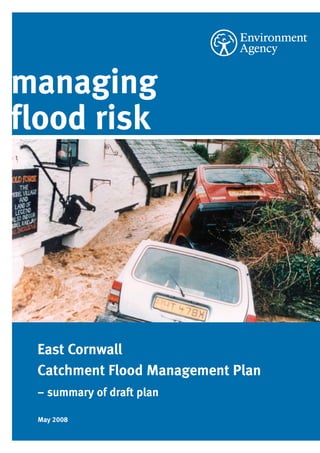
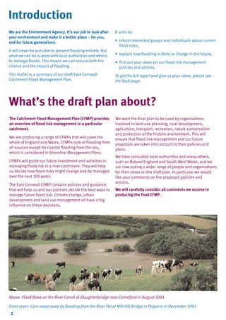
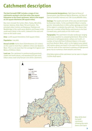
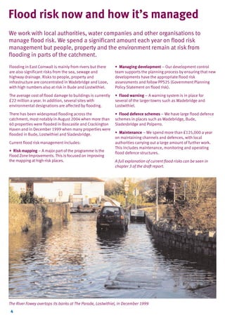
The document is a summary of the East Cornwall Catchment Flood Management Plan (CFMP). It describes the flood risks in the area and sets out policies and actions to manage those risks over the next century. The CFMP divides the catchment into areas with similar flood risk characteristics called policy units. For each unit it identifies one of six policies to reduce, accept, or take advantage of flood risk. The actions proposed include flood storage schemes, maintaining existing flood defenses, surface water management plans, and working with landowners to reduce runoff. The goal is to implement the policies through cooperation with local authorities and other groups.
Climate change and natural resources management in SIDS in the context of imp...FAO
Presentation made in the context of the FAO-led side event “Improved Food Security, Nutrition and Livelihoods: Addressing climate change and natural resources threats in SIDS”, in the context of the Third International Conference on Small Island Developing States, held in Samoa from 1-4 September 2014.
Presentation by Dr A Qayyum, Comprehensive Disaster Management Programme, Bangladesh at the CCAFS Workshop on Institutions and Policies to Scale out Climate Smart Agriculture held between 2-5 December 2013 in Colombo, Sri Lanka.
Retrofitting urban streams for resiliency, National Planning Conference, San ...Cornell University
This poster explores planning and design strategies for implementing urban stream restoration and flood-mitigation for the dilapidated Coney Island creek in New York. The low-lying coastal community of Coney Island presents opportunities to plan for an inclusive development triggered by renewal of its creek, that would conceivably translate into economic development and social upliftment for that neighborhood.
004 Future Coastal Flood and Erosion Risk Management Schemes at Southsea and ...djhutch
Presentation given by Bret Davies (Havant, Portsmouth & Gosport Coastal Defence Partnership) at UPEN workshop - Climate change and the Solent: Opportunities and Vulnerabilities.
Natural calamities do happen; disasters above certain magnitude are beyond human control. Nevertheless, mutely suffering in the PRESENT repeating the mistakes of the PAST without seeking ways and means to bring in changes for the benefit of FUTURE is meaningless.
Brief Description of Kerala Flood of 2018
and In starting some flood infomation is also discussed
and also given information about donation by diffferent peoples and commpanys and states.
Etude PwC/Economist Intelligence Unit sur l'utilisation des data dans la pris...PwC France
http://bit.ly/DataAnalyticsPwC
La majorité des dirigeants interrogés dans le monde (94 %) indiquent que la direction de leur entreprise est armée pour prendre des décisions majeures concernant l'orientation stratégique de l'activité. Toutefois, à peine un tiers d'entre eux se sont appuyés en premier lieu sur des données et des outils analytiques pour prendre leur dernière grande décision ; 58 % des dirigeants se sont fiés à leur instinct ou à leur expérience, et ont fait appel aux conseils prodigués par d'autres collaborateurs de leur organisation.
Introduction to ‘Socio-Cultural Ecology’ and User Generated Contexts. ALT-C Workshop: Navigating Through the Storm – Using Theory to Plan Mobile Learning Deployment. #altc2010
http://bit.ly/GEWjuin2014PwC
Le Brésil accueille la Coupe du Monde de football ce mois-ci. Cet événement sportif va mettre l'accent sur une économie des BRIC qui a traversé une période difficile depuis la crise financière.
Climate change vulnerability and adaptation in Egygpt and NAP processNAP Events
Presented by: Mohamed Ismail Ibrahim Elsehamy
7.2 Approaches / adaptation solutions (1/2)
The section will provide best practices regarding various adaptation approaches or solutions at various scales based on latest science. Examples to be featured include ecosystem-based approaches, community based adaptation, responses to heat waves and ways to deal with shifting growing seasons in agriculture. The session will also feature practical experiences from countries in addressing issues at multiple scales. This is the first of two sessions on this topic. The second is under session 8.1.
Castle Debates - Managing the environmental impacts of new housing developmentsGeoSmart Information
With climate change very real and creating severe weather events anywhere in the country, new developments must take account of sustainable drainage within scheme design.
Dr. Paul Ellis, GeoSmart Information's Innovation Director, outlines how development and sound environmental management could go hand in hand.
Current Status of CRZ It’s implementation. by-Vasudev P. Mahale Ecotist
Details of the immense fieldwork required for accurately determining the high tide line (HTL). As clear from the CRZ notification 2011, HTL is an extremely significant parameter for determining the various coastal zones.
An overview of more than two hundred river improvement projects that were delivered by 28 individual rivers trusts throughout England between 2010 - 2014.
Encryption in Microsoft 365 - ExpertsLive Netherlands 2024Albert Hoitingh
In this session I delve into the encryption technology used in Microsoft 365 and Microsoft Purview. Including the concepts of Customer Key and Double Key Encryption.
DevOps and Testing slides at DASA ConnectKari Kakkonen
My and Rik Marselis slides at 30.5.2024 DASA Connect conference. We discuss about what is testing, then what is agile testing and finally what is Testing in DevOps. Finally we had lovely workshop with the participants trying to find out different ways to think about quality and testing in different parts of the DevOps infinity loop.
The Art of the Pitch: WordPress Relationships and SalesLaura Byrne
Clients don’t know what they don’t know. What web solutions are right for them? How does WordPress come into the picture? How do you make sure you understand scope and timeline? What do you do if sometime changes?
All these questions and more will be explored as we talk about matching clients’ needs with what your agency offers without pulling teeth or pulling your hair out. Practical tips, and strategies for successful relationship building that leads to closing the deal.
Elevating Tactical DDD Patterns Through Object CalisthenicsDorra BARTAGUIZ
After immersing yourself in the blue book and its red counterpart, attending DDD-focused conferences, and applying tactical patterns, you're left with a crucial question: How do I ensure my design is effective? Tactical patterns within Domain-Driven Design (DDD) serve as guiding principles for creating clear and manageable domain models. However, achieving success with these patterns requires additional guidance. Interestingly, we've observed that a set of constraints initially designed for training purposes remarkably aligns with effective pattern implementation, offering a more ‘mechanical’ approach. Let's explore together how Object Calisthenics can elevate the design of your tactical DDD patterns, offering concrete help for those venturing into DDD for the first time!
GraphRAG is All You need? LLM & Knowledge GraphGuy Korland
Guy Korland, CEO and Co-founder of FalkorDB, will review two articles on the integration of language models with knowledge graphs.
1. Unifying Large Language Models and Knowledge Graphs: A Roadmap.
https://arxiv.org/abs/2306.08302
2. Microsoft Research's GraphRAG paper and a review paper on various uses of knowledge graphs:
https://www.microsoft.com/en-us/research/blog/graphrag-unlocking-llm-discovery-on-narrative-private-data/
Dev Dives: Train smarter, not harder – active learning and UiPath LLMs for do...UiPathCommunity
💥 Speed, accuracy, and scaling – discover the superpowers of GenAI in action with UiPath Document Understanding and Communications Mining™:
See how to accelerate model training and optimize model performance with active learning
Learn about the latest enhancements to out-of-the-box document processing – with little to no training required
Get an exclusive demo of the new family of UiPath LLMs – GenAI models specialized for processing different types of documents and messages
This is a hands-on session specifically designed for automation developers and AI enthusiasts seeking to enhance their knowledge in leveraging the latest intelligent document processing capabilities offered by UiPath.
Speakers:
👨🏫 Andras Palfi, Senior Product Manager, UiPath
👩🏫 Lenka Dulovicova, Product Program Manager, UiPath
Neuro-symbolic is not enough, we need neuro-*semantic*Frank van Harmelen
Neuro-symbolic (NeSy) AI is on the rise. However, simply machine learning on just any symbolic structure is not sufficient to really harvest the gains of NeSy. These will only be gained when the symbolic structures have an actual semantics. I give an operational definition of semantics as “predictable inference”.
All of this illustrated with link prediction over knowledge graphs, but the argument is general.
GDG Cloud Southlake #33: Boule & Rebala: Effective AppSec in SDLC using Deplo...James Anderson
Effective Application Security in Software Delivery lifecycle using Deployment Firewall and DBOM
The modern software delivery process (or the CI/CD process) includes many tools, distributed teams, open-source code, and cloud platforms. Constant focus on speed to release software to market, along with the traditional slow and manual security checks has caused gaps in continuous security as an important piece in the software supply chain. Today organizations feel more susceptible to external and internal cyber threats due to the vast attack surface in their applications supply chain and the lack of end-to-end governance and risk management.
The software team must secure its software delivery process to avoid vulnerability and security breaches. This needs to be achieved with existing tool chains and without extensive rework of the delivery processes. This talk will present strategies and techniques for providing visibility into the true risk of the existing vulnerabilities, preventing the introduction of security issues in the software, resolving vulnerabilities in production environments quickly, and capturing the deployment bill of materials (DBOM).
Speakers:
Bob Boule
Robert Boule is a technology enthusiast with PASSION for technology and making things work along with a knack for helping others understand how things work. He comes with around 20 years of solution engineering experience in application security, software continuous delivery, and SaaS platforms. He is known for his dynamic presentations in CI/CD and application security integrated in software delivery lifecycle.
Gopinath Rebala
Gopinath Rebala is the CTO of OpsMx, where he has overall responsibility for the machine learning and data processing architectures for Secure Software Delivery. Gopi also has a strong connection with our customers, leading design and architecture for strategic implementations. Gopi is a frequent speaker and well-known leader in continuous delivery and integrating security into software delivery.
Epistemic Interaction - tuning interfaces to provide information for AI supportAlan Dix
Paper presented at SYNERGY workshop at AVI 2024, Genoa, Italy. 3rd June 2024
https://alandix.com/academic/papers/synergy2024-epistemic/
As machine learning integrates deeper into human-computer interactions, the concept of epistemic interaction emerges, aiming to refine these interactions to enhance system adaptability. This approach encourages minor, intentional adjustments in user behaviour to enrich the data available for system learning. This paper introduces epistemic interaction within the context of human-system communication, illustrating how deliberate interaction design can improve system understanding and adaptation. Through concrete examples, we demonstrate the potential of epistemic interaction to significantly advance human-computer interaction by leveraging intuitive human communication strategies to inform system design and functionality, offering a novel pathway for enriching user-system engagements.
Epistemic Interaction - tuning interfaces to provide information for AI support
East Cornwall CFMP
1. East Cornwall CFMP.QXD
5/15/08
12:51 PM
Page 1
managing
flood risk
East Cornwall
Catchment Flood Management Plan
– summary of draft plan
May 2008
2. TYPE_6_EAST_CORNWALL_V1.QXD
5/22/08
3:47 PM
Page 2
Introduction
We are the Environment Agency. It’s our job to look after
your environment and make it a better place – for you,
and for future generations.
It will never be possible to prevent flooding entirely. But
what we can do is work with local authorities and others
to manage floods. This means we can reduce both the
chance and the impact of flooding.
This leaflet is a summary of our draft East Cornwall
Catchment Flood Management Plan.
It aims to:
• inform interested groups and individuals about current
flood risks;
• explain how flooding is likely to change in the future;
• find out your views on our flood risk management
policies and actions.
To get the full report and give us your views, please see
the back page.
What’s the draft plan about?
The Catchment Flood Management Plan (CFMP) provides
an overview of flood risk management in a particular
catchment.
We are producing a range of CFMPs that will cover the
whole of England and Wales. CFMPs look at flooding from
all sources except for coastal flooding from the sea,
which is considered in Shoreline Management Plans.
CFMPs will guide our future investment and activities in
managing flood risk in a river catchment. They will help
us decide how flood risks might change and be managed
over the next 100 years.
The East Cornwall CFMP contains policies and guidance
that will help us and our partners decide the best ways to
manage future flood risk. Climate change, urban
development and land use management all have a big
influence on these decisions.
We want the final plan to be used by organisations
involved in land use planning, rural development,
agriculture, transport, recreation, nature conservation
and protection of the historic environment. This will
ensure that flood risk management and our future
proposals are taken into account in their policies and
plans.
We have consulted local authorities and many others,
such as Natural England and South West Water, and we
are now asking a wider range of people and organisations
for their views on the draft plan. In particular we would
like your comments on the proposed policies and
actions.
We will carefully consider all comments we receive in
producing the final CFMP.
Above: Flood flows on the River Camel at Slaughterbridge near Camelford in August 2004
Front cover: Cars swept away by flooding from the River Pol at Mill Hill Bridge in Polperro in December 1993
2
3. TYPE_6_EAST_CORNWALL_V1.QXD
5/22/08
3:47 PM
Page 3
Catchment description
The East Cornwall CFMP includes a range of river
catchments varying in size from only a few square
kilometres to the Camel catchment, which is the largest
at 235 square kilometres (90 square miles).
Key rivers include the Camel, Allen, Fowey, Menalhyl,
Gannel, Valency, Strat, Neet, Pol and Seaton. The
principal urban centres are Newquay, Padstow and
Wadebridge in the north-west, Bodmin and Fowey in the
south-west, Bude in the north, Liskeard in the east and
Looe on the south coast.
Area: 1,400 square kilometres (540 square miles).
Population: 146,000.
Annual rainfall: Varies from 850millimetres (33 inches)
on the coast to more than 1,800mm (70in) over Bodmin
Moor. This is a lot more than the average for England and
Wales of 920mm (36in).
Land use: The catchment is predominantly grassland,
arable and horticultural, and woodland (93 per cent).
Urban areas cover only five per cent of the catchment.
Environmental designations: Eight Special Areas of
Conservation, two National Nature Reserves, 46 Sites of
Special Scientific Interest and 190 County Wildlife Sites.
Geology: The south and north of the area are dominated
by Devonian slates. To the east Bodmin Moor is mainly
granite. Generally there is little surface geology and most
of the region is underlain by solid rock. This means that
there are a number of fast flashy catchments in the East
Cornwall area, particularly on the north coast.
Topography: The catchment includes landscape ranging
from rocky coastline to undulating farmland. Most of the
catchment is rolling grassland, valleys and heaths. A
number of rivers fall from St Breock Downs in the west
and from Bodmin Moor, which is the highest area (about
360 metres above sea level) in the east of the catchment.
In the far north of the catchment a plateau of high ground
gives rise to numerous short streams and rivers.
A full description of the catchment can be seen in chapter
2 of the draft report.
Map of the East
Cornwall
catchment
showing the main
towns and rivers
3
4. TYPE_6_EAST_CORNWALL_V1.QXD
5/22/08
3:47 PM
Page 4
Flood risk now and how it’s managed
We work with local authorities, water companies and other organisations to
manage flood risk. We spend a significant amount each year on flood risk
management but people, property and the environment remain at risk from
flooding in parts of the catchment.
Flooding in East Cornwall is mainly from rivers but there
are also significant risks from the sea, sewage and
highway drainage. Risks to people, property and
infrastructure are concentrated in Wadebridge and Looe,
with high numbers also at risk in Bude and Lostwithiel.
• Managing development – Our development control
team supports the planning process by ensuring that new
developments have the appropriate flood risk
assessments and follow PPS25 (Government Planning
Policy Statement on flood risk).
The average cost of flood damage to buildings is currently
£22 million a year. In addition, several sites with
environmental designations are affected by flooding.
• Flood warning – A warning system is in place for
several of the larger towns such as Wadebridge and
Lostwithiel.
There has been widespread flooding across the
catchment, most notably in August 2004 when more than
60 properties were flooded in Boscastle and Crackington
Haven and in December 1999 when many properties were
flooded in Bude, Lostwithiel and Sladesbridge.
• Flood defence schemes – We have large flood defence
schemes in places such as Wadebridge, Bude,
Sladesbridge and Polperro.
Current flood risk management includes:
• Risk mapping – A major part of the programme is the
Flood Zone Improvements. This is focused on improving
the mapping at high-risk places.
• Maintenance – We spend more than £125,000 a year
on maintaining channels and defences, with local
authorities carrying out a large amount of further work.
This includes maintenance, monitoring and operating
flood defence structures.
A full explanation of current flood risks can be seen in
chapter 3 of the draft report.
The River Fowey overtops its banks at The Parade, Lostwithiel, in December 1999
4
5. TYPE_6_EAST_CORNWALL_V1.QXD
5/22/08
3:47 PM
Page 5
What the future could bring
We have investigated possible changes in the East Cornwall catchment and
looked at the effects of climate change, urban development and other changes in
land use.
Our conclusions from these studies are set out below.
Climate change
Climate change will bring more winter rainfall. Higher
average summer temperatures will mean a greater risk of
thunderstorms and flash flooding. Guidance from Defra
suggests this could increase river flows by 20 per cent by
2100.
Sea level is predicted to rise by more than 800mm (30in)
by 2100 which will increase tidal flooding.
Urban development
The most significant increases in urban development are
likely to be in Newquay and Bodmin. If not managed this
could increase run-off and flood risk.
Land use and management
There is a strong link between how the land is used and
managed and the run-off generated by a plot or individual
field. However, we are still researching the effect that the
use and management of rural land has on flooding at a
catchment scale.
There could be an increase in flow of about 10 per cent
across East Cornwall by 2100 if changes in land use
remain unchecked.
Summary of key future flood risks
Flood risk will increase. Bude, Bodmin, Looe, Lostwithiel,
Wadebridge and Polperro are likely to experience the
greatest flood risk.
The detailed assessment of future flood risks can be
found in chapter 4 of the draft report.
A man struggles
against
floodwater
sweeping
through the
centre of
Polperro in
December 1993
5
6. TYPE_6_EAST_CORNWALL_V1.QXD
5/22/08
3:47 PM
Page 6
Above: A helicopter flies in to rescue people trapped in the Boscastle floods of August 2004
Photo: Pam Durrant
Below: An engineer checks levels in the deepened channel of the River Valency at Boscastle in June 2007 – the
Environment Agency is spending £4.6 million on improvements to reduce flood risk in the village, including deepening
and widening the Valency, after completing flood risk improvements on the lower River Jordan
6
7. TYPE_6_EAST_CORNWALL_V1.QXD
5/22/08
3:47 PM
Page 7
Our objectives for the catchment
The main aim of the CFMP is to develop policies for flood risk management within
the East Cornwall catchment now and in the future.
We have developed detailed objectives for the management of flood risk in the catchment. We have used these to
assess which policies are the most appropriate.
Social objectives
• Prevent injuries and loss of life from flooding.
• Reduce flood risk to vulnerable communities and protect and improve recreation facilities where possible.
Economic objectives
• Reduce flood risk to residential, commercial and industrial property.
• Reduce flood risk to critical infrastructure, in particular the A30, A38 and main railway line.
• Minimise disturbance to agricultural land.
Environmental objectives
• Protect and work with natural river processes, and restore streams and rivers to their natural state
• Protect and improve nationally-important wildlife sites and protected habitats and species.
• Prevent pollution resulting from flooding of urban and agricultural land.
• Protect the quality of land and encourage changes in land use management to reduce run-off.
• Protect and enhance heritage features.
• Protect and enhance landscape character and visual amenity.
We have also considered what else is going on in the catchment that our objectives may help to achieve (the
opportunities) and also what could limit our success in achieving them (the constraints).
More detail of the objectives, opportunities and constraints for future management can be seen in chapter 5 of the draft
report.
This couple
had to be
rescued by
helicopter
from the roof
of their
bungalow
after it was
surrounded by
floods from
the River Neet
in August
2004
7
9. TYPE_6_EAST_CORNWALL_V1.QXD
5/22/08
3:47 PM
Page 9
How we chose policies
We divided the catchment into policy units with similar flood risk characteristics.
We then considered alternative policies for these units and decided which would
best achieve the social, economic and environmental objectives.
The following alternative policies (P1 to P6) were
considered. These policies are being used for all CFMPs
across England and Wales.
P1
No active intervention
This policy applies where there is little or no flood risk to
people, property and the environment and no existing
flood risk management. We will continue to monitor and
advise.
P2
Reduce existing flood risk management actions
This policy means accepting the current and future
increases in flood risk. It applies to areas where there is
currently some flood risk management but existing and
future risks are not enough to justify these activities.
P3
Continue existing or alternative actions
With this policy the current scale of flood risk
management is sufficient. We accept that flood risk will
increase over time and will not increase our activities to
deal with this rise in risk.
P4 Take further action to sustain the current scale of
flood risk
This policy applies where the current risk is acceptable
but future changes are expected to have a significant
impact. Flood risk management activities need to respond
to the potential increases in flood risk.
P5
Take further action to reduce flood risk
This is a policy to reduce the risk where the consequences
of flooding are currently too high and
will continue to increase in the future.
The action can include improving flood
risk management and reducing, or even
removing, development in the
floodplain.
P6 Take action to increase the
frequency of flooding
Risk will be reduced in the catchment
overall by implementing this policy
where an increase in the frequency,
duration or magnitude of flooding will
be beneficial. This is likely to apply to
upper catchment areas where there are
opportunities to restore the floodplain
or there are environmental benefits
such as habitat creation. Through
storing water this policy can reduce risk
downstream. This policy is not intended
to increase risk to people and property.
See plan on p10 showing policies
chosen for each unit.
Chapter 6 of the draft report has more
detail on how and why we chose the
policies for each unit.
Left: Flooding from the Trenance Stream
and high tide affects shops in the centre
of Newquay in the 1960s
9
11. TYPE_6_EAST_CORNWALL_V1.QXD
5/22/08
3:47 PM
Page 11
How we plan to manage flood risk
We will meet the catchment objectives and deliver the policies by implementing
the action plan outlined below. To achieve these actions we must work with other
organisations including local authorities, Natural England and South West Water.
Bodmin Moor – Policy 6
• Investigate flow storage by enhancing wetland in the
Upper Fowey, and using Siblyback Reservoir, Colliford
Lake and disused china clay workings.
• Prepare Surface Water Management Plan for
Wadebridge.
• Create community-based tidal warnings.
Gannel and Mawgan Vale – Policy 3
Fowey and Seaton Valleys – Policy 4
• Maintain existing standard of protection at Polperro.
• Prepare Surface Water Management Plan for Liskeard.
• Improve A38 drainage east of Bodmin.
• Investigate the links between land management
practices, run-off and flood risk.
• Maintain existing defences at Mawgan Porth and St
Columb Major.
• Review flood risk in Newquay and ensure PPS25 is
applied to new development.
North Coast Rivers – Policy 4
• Maintain existing standard of protection for Boscastle.
South Coast Tidal – Policy 5
• Investigate measures to reduce flood risk at Looe,
Fowey and Seaton.
• Review options to reduce flood risk at Lostwithiel.
• Maintain existing tidal defences at Polperro.
• Progress with the outcomes of the Rapid Response
Catchment Study.
• Raise and maintain awareness of flood risk and selfhelp measures.
• Continue targeted channel maintenance.
• Create community-based tidal warnings.
• Investigate the links between land management
practices, run-off and flood risk.
Camel Valley – Policy 3
Bude and Stratton – Policy 5
• Maintain current scale of management in Camelford,
Lanivet and Bodmin.
• Review flood risk at Bude and undertake work to
reduce risk if justified.
• Investigate the links between land management
practices, run-off and flood risk.
• Maintain existing defences at Stratton, Flexbury and
Helebridge.
• Relocate Bodmin Fire Station in long term.
• Create community-based tidal warnings.
• Raise and maintain awareness of flood risk and selfhelp measures.
Welcombe and Coombe Valleys – Policy 1
• No active intervention.
Camel Tidal – Policy 5
• Maintain existing defences and improve flood warning
at Sladesbridge.
To find out how we would like each organisation to be
involved in implementing these actions, please see
chapter 7 of the draft report.
• Review flood risk at Wadebridge and undertake work to
reduce risk if justified.
11
12. TYPE_6_EAST_CORNWALL_V1.QXD
5/22/08
3:47 PM
Page 12
Flooding from the River Gannel at Newquay in September 1974 – we plan to reduce the risk of floods like this
Next steps
We want your views on the draft plan and will consider them in the production of the final plan.
Once we have published the East Cornwall CFMP, we will monitor how it is being used and that its policies and
actions are being achieved. The CFMP will be a ‘living document’ that develops as we improve our understanding of
flood risk and will be reviewed at least every six years.
How to comment
Your views are vital for our public consultation on this draft plan. It is available on a CD from Steve Stanbridge – to
obtain a copy, email steven.stanbridge@environment-agency.gov.uk, call him on 01392 442152 or write to him at
the address below.
You can also study a printed copy of the draft plan at our Cornwall Area office at Sir John Moore House, Victoria
Square, Bodmin. The office is open Monday to Friday from 9am to 5pm.
More information is available from our website, www.environment-agency.gov.uk/cfmp
We will consider all comments we receive before 27 June 2008. Please email them to
steven.stanbridge@environment-agency.gov.uk or post them to:
Steve Stanbridge
Environment Agency
Manley House
Kestrel Way
Exeter
EX2 7LQ
GESW0508BMTS-E-P
Editing & design: Westword
Printed on Take 2 Silk made from post-consumer waste