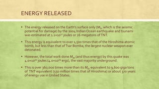
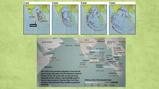
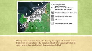
SUMATRA EARTHQUAKE
AR4051 DISASTER MANAGEMENT & EARTHQUAKE RESISTANT BUILDINGS
GROUP MEMBERS:
▪ ABHAY KUMAR
▪ ANANYATALUKDAR
▪ DOMMETI PRASHANTH
▪ LAKSHMI RAVI CHANDU
▪ LABANYA BAIDYA
▪ NARESH
INTRODUCTION
▪ The 2004 Indian Ocean earthquake occurred at 00:58:53 UTC on 26 December
with the epicentre off the west coast of Sumatra, Indonesia.
▪ The shock had a moment magnitude of 9.1–9.3 and a maximum Mercalli
intensity of IX (Violent).
▪ The undersea megathrust earthquake was caused when the Indian Plate
was subducted by the Burma Plate and triggered a series of devastating tsunamis
along the coasts of most landmasses bordering the Indian Ocean.
▪ It cause a killing of 230,000–280,000 people in 14 countries, and inundating coastal
communities with waves up to 30 metres high.
▪ It was one of the deadliest natural disaster recorded in history.
▪ Indonesia was the hardest-hit country, followed by Sri Lanka, India, andThailand.
INTRODUCTION
▪ It is the third largest earthquake ever recorded on a seismograph and had
the longest duration of faulting ever observed between 8.3 and 10 minutes.
▪ It caused the entire planet to vibrate as much as 1 centimetre (0.4
inches) and triggered other earthquakes as far away as Alaska.
▪ Its epicentre was between Simeulue and mainland Indonesia.
▪ The resulting tsunami was given various names, including the 2004 Indian
Ocean tsunami, South Asian tsunami, Indonesian tsunami, the Christmas
tsunami and the Boxing Day tsunami.
FORESHOCK:
▪ The 2002 Sumatra
earthquake occurred at 01:26 UTC on
2 November.
▪ It had a magnitude of 7.3 on
the moment magnitude scale with
an epicentre just north
of Simulue island and caused three
deaths.
▪ This earthquake is regarded as
a foreshock of the 2004 Sumatra
earthquake, which had an epicentre
about 60 km to the northwest.
 INTERSEISMIC:
• India subducts beneath
Burma microplate
at about 50 mm/yr.
• Fault interface is
locked.
 EARTHQUAKE
(COSEISMIC):
• Fault interface slips,
overriding plate
rebounds, releasing
accumulated motion.
TECTONIC PLATES:
N• 26th December 2004 00h 58min 51s
UT
• Western COAST OF NORTHERN
SUMATRA
• Epicentre
latitude : 3.298°
longitude : 95.778°
• Magnitude = 9.2
• 3rd largest Earthquake since ever
recorded on a seismograph.
TECTONIC PLATES:
Seismograms of the day: Global Seismic
Displacement Wavefield, December 26,
2004.
AFTERSHOCKS & OTHER EARTHQUAKES
▪ Numerous aftershocks were reported off the Andaman and Nicobar
islands and the region of the original epicentre in the hours and days
that followed.
▪ The magnitude 8.7 2005 Nias – Simulue earthquake, which originated
off the coast of the Sumatran island of Nias, is not considered an
aftershock, despite its proximity to the epicentre, and was most
likely triggered by stress changes associated with the 2004 event.
▪ This earthquake was so large that it produced its own aftershocks
(some registering a magnitude of as great as 6.1) and presently ranks
as the 7th largest earthquake on record since 1900.
▪ Other aftershocks of up to magnitude 6.6
continued to shake the region daily for
up to three or four months.
▪ As well as continuing aftershocks, the
energy released by the original
earthquake continued to make its
presence felt well after the event.
▪ A week after the earthquake, its
reverberations could still be measured,
providing valuable scientific data about
the Earth's interior.
AFTERSHOCKS & OTHER EARTHQUAKES
ENERGY RELEASED
▪ The energy released on the Earth's surface only (ME, which is the seismic
potential for damage) by the 2004 Indian Ocean earthquake and tsunami
was estimated at 1.1×10¹⁷ joules or 26 megatons ofTNT.
▪ This energy is equivalent to over 1,500 times that of the Hiroshima atomic
bomb, but less than that ofTsar Bomba, the largest nuclear weapon ever
detonated.
▪ However, the total work done MW (and thus energy) by this quake was
4.0×10²² joules (4.0×1029 ergs), the vast majority underground.
▪ This is over 360,000 times more than its ME, equivalent to 9,600 giga tons
of TNT equivalent (550 million times that of Hiroshima) or about 370 years
of energy use in United States.
TSUNAMI
• All along the rupture the seafloor
was shunted vertically by about 10
meters.
• This movement displaced the
overlying water, generating a
massive tsunami, or tidal wave.
• The wave then fanned out across
the Indian Ocean at enormous
speed.
▪ The tsunami, like all others, behaved very differently in deep water
than in shallow water.
▪ In deep ocean water, tsunami waves form only a small hump,
barely noticeable and harmless, which generally travels at a very
high speed of 500 to 1,000 km/h (310 to 620 mph).
▪ In shallow water near coastlines, a tsunami slows down to only
tens of kilometres per hour but, in doing so, forms large
destructive waves.
▪ Scientists investigating the damage in Aceh found evidence that
the wave reached a height of 24 metres (80 ft) when coming
ashore along large stretches of the coastline, rising to 30 metres
(100 ft) in some areas when traveling inland.
TSUNAMI
Scale showing size of tsunami
waves that hit Indonesia
IN DEEP OCEAN tsunami has long wavelength, travels fast,
small amplitude - doesn’t affect ships.
AS IT APPROACHES SHORE, it slows. Since energy is conserved,
amplitude builds up - very damaging.
TSUNAMI
TSUNAMI
 Animation of tsunami
caused by the earthquake
showing how it radiated
from the entire length of
the 1,600 km (990 mi)
rupture.
 Damage map of Banda Aceh city showing the impact of tsunamis wave
fronts from two directions. The numerals indicate the tsunami elevation in
meters near the beach (white) and flow depth inland (black).
Banda Aceh City,
Sumarta
BEFORE AFTER
 A three story house damaged by the tsunami showing
the tsunami inundation height in downtown Banda
Aceh.
THE DESTRUCTION CAUSED:
Scale of devastation
Thousands are reported to have been killed,
but there has been little news from the
worst-hit areas where all transport and
communication links were destroyed.
• Low lying coastal areas were
left obliterated and flooded
as here in Aceh province in
Sumatra, Indonesia.
• Current reports indicate that
the north and west coasts of
Sumatra have experienced
the worst destruction.
• Low lying areas have been
left flooded with seawater
which quickly becomes
contaminated with sewage
and decomposing bodies.
THE DESTRUCTION CAUSED:
▪ In Aceh, Indonesia, so many doctors have been killed that there are
few trained medical workers to assist the injured.
THE DESTRUCTION CAUSED:
• Increasing numbers of
homeless people needing
shelter, food and water.
• Clean drinking water is
required to avoid the spread of
disease.
THE DESTRUCTION CAUSED:
PROBLEMS FACED
• In all affected areas survivors are hungry as food supplies run out.
• The threat of disease increases.
• Medicines are needed desperately.
• In some areas relief supplies are piling up.
• Disruption of communications means that emergency supplies
cannot be distributed efficiently.
• Co-ordination of relief efforts from throughout the world is
proving to be a major challenge.
• Four days after the tsunami many of the worst affected areas
cannot be reached.
EVACUATION
• The evacuation of foreign tourists from the beach resorts
begins.
• Other survivors, such as these women and children from
the Nicobar Islands, leave to a more uncertain future.
• Relief efforts, which have been slow to start, gather pace as
the enormity of the disaster begins to be appreciated.
Effects on other countries
• Whole villages were flattened as here in Sri Lanka
Scenes which were repeated across the Indian Ocean
Sri Lanka Phuket,Thailand
Millions of people have been left homeless
Cuddalore, south of Madras, India Penang, Malaysia
Thankyou

Sumatra earthquake - Tsunami

  • 1.
    SUMATRA EARTHQUAKE AR4051 DISASTERMANAGEMENT & EARTHQUAKE RESISTANT BUILDINGS
  • 2.
    GROUP MEMBERS: ▪ ABHAYKUMAR ▪ ANANYATALUKDAR ▪ DOMMETI PRASHANTH ▪ LAKSHMI RAVI CHANDU ▪ LABANYA BAIDYA ▪ NARESH
  • 3.
    INTRODUCTION ▪ The 2004Indian Ocean earthquake occurred at 00:58:53 UTC on 26 December with the epicentre off the west coast of Sumatra, Indonesia. ▪ The shock had a moment magnitude of 9.1–9.3 and a maximum Mercalli intensity of IX (Violent). ▪ The undersea megathrust earthquake was caused when the Indian Plate was subducted by the Burma Plate and triggered a series of devastating tsunamis along the coasts of most landmasses bordering the Indian Ocean. ▪ It cause a killing of 230,000–280,000 people in 14 countries, and inundating coastal communities with waves up to 30 metres high. ▪ It was one of the deadliest natural disaster recorded in history. ▪ Indonesia was the hardest-hit country, followed by Sri Lanka, India, andThailand.
  • 4.
    INTRODUCTION ▪ It isthe third largest earthquake ever recorded on a seismograph and had the longest duration of faulting ever observed between 8.3 and 10 minutes. ▪ It caused the entire planet to vibrate as much as 1 centimetre (0.4 inches) and triggered other earthquakes as far away as Alaska. ▪ Its epicentre was between Simeulue and mainland Indonesia. ▪ The resulting tsunami was given various names, including the 2004 Indian Ocean tsunami, South Asian tsunami, Indonesian tsunami, the Christmas tsunami and the Boxing Day tsunami.
  • 5.
    FORESHOCK: ▪ The 2002Sumatra earthquake occurred at 01:26 UTC on 2 November. ▪ It had a magnitude of 7.3 on the moment magnitude scale with an epicentre just north of Simulue island and caused three deaths. ▪ This earthquake is regarded as a foreshock of the 2004 Sumatra earthquake, which had an epicentre about 60 km to the northwest.
  • 6.
     INTERSEISMIC: • Indiasubducts beneath Burma microplate at about 50 mm/yr. • Fault interface is locked.  EARTHQUAKE (COSEISMIC): • Fault interface slips, overriding plate rebounds, releasing accumulated motion. TECTONIC PLATES:
  • 7.
    N• 26th December2004 00h 58min 51s UT • Western COAST OF NORTHERN SUMATRA • Epicentre latitude : 3.298° longitude : 95.778° • Magnitude = 9.2 • 3rd largest Earthquake since ever recorded on a seismograph. TECTONIC PLATES:
  • 8.
    Seismograms of theday: Global Seismic Displacement Wavefield, December 26, 2004.
  • 9.
    AFTERSHOCKS & OTHEREARTHQUAKES ▪ Numerous aftershocks were reported off the Andaman and Nicobar islands and the region of the original epicentre in the hours and days that followed. ▪ The magnitude 8.7 2005 Nias – Simulue earthquake, which originated off the coast of the Sumatran island of Nias, is not considered an aftershock, despite its proximity to the epicentre, and was most likely triggered by stress changes associated with the 2004 event. ▪ This earthquake was so large that it produced its own aftershocks (some registering a magnitude of as great as 6.1) and presently ranks as the 7th largest earthquake on record since 1900.
  • 10.
    ▪ Other aftershocksof up to magnitude 6.6 continued to shake the region daily for up to three or four months. ▪ As well as continuing aftershocks, the energy released by the original earthquake continued to make its presence felt well after the event. ▪ A week after the earthquake, its reverberations could still be measured, providing valuable scientific data about the Earth's interior. AFTERSHOCKS & OTHER EARTHQUAKES
  • 11.
    ENERGY RELEASED ▪ Theenergy released on the Earth's surface only (ME, which is the seismic potential for damage) by the 2004 Indian Ocean earthquake and tsunami was estimated at 1.1×10¹⁷ joules or 26 megatons ofTNT. ▪ This energy is equivalent to over 1,500 times that of the Hiroshima atomic bomb, but less than that ofTsar Bomba, the largest nuclear weapon ever detonated. ▪ However, the total work done MW (and thus energy) by this quake was 4.0×10²² joules (4.0×1029 ergs), the vast majority underground. ▪ This is over 360,000 times more than its ME, equivalent to 9,600 giga tons of TNT equivalent (550 million times that of Hiroshima) or about 370 years of energy use in United States.
  • 12.
    TSUNAMI • All alongthe rupture the seafloor was shunted vertically by about 10 meters. • This movement displaced the overlying water, generating a massive tsunami, or tidal wave. • The wave then fanned out across the Indian Ocean at enormous speed.
  • 13.
    ▪ The tsunami,like all others, behaved very differently in deep water than in shallow water. ▪ In deep ocean water, tsunami waves form only a small hump, barely noticeable and harmless, which generally travels at a very high speed of 500 to 1,000 km/h (310 to 620 mph). ▪ In shallow water near coastlines, a tsunami slows down to only tens of kilometres per hour but, in doing so, forms large destructive waves. ▪ Scientists investigating the damage in Aceh found evidence that the wave reached a height of 24 metres (80 ft) when coming ashore along large stretches of the coastline, rising to 30 metres (100 ft) in some areas when traveling inland. TSUNAMI Scale showing size of tsunami waves that hit Indonesia
  • 14.
    IN DEEP OCEANtsunami has long wavelength, travels fast, small amplitude - doesn’t affect ships. AS IT APPROACHES SHORE, it slows. Since energy is conserved, amplitude builds up - very damaging. TSUNAMI
  • 15.
    TSUNAMI  Animation oftsunami caused by the earthquake showing how it radiated from the entire length of the 1,600 km (990 mi) rupture.
  • 17.
     Damage mapof Banda Aceh city showing the impact of tsunamis wave fronts from two directions. The numerals indicate the tsunami elevation in meters near the beach (white) and flow depth inland (black).
  • 18.
  • 19.
     A threestory house damaged by the tsunami showing the tsunami inundation height in downtown Banda Aceh.
  • 20.
    THE DESTRUCTION CAUSED: Scaleof devastation Thousands are reported to have been killed, but there has been little news from the worst-hit areas where all transport and communication links were destroyed.
  • 21.
    • Low lyingcoastal areas were left obliterated and flooded as here in Aceh province in Sumatra, Indonesia. • Current reports indicate that the north and west coasts of Sumatra have experienced the worst destruction. • Low lying areas have been left flooded with seawater which quickly becomes contaminated with sewage and decomposing bodies. THE DESTRUCTION CAUSED:
  • 22.
    ▪ In Aceh,Indonesia, so many doctors have been killed that there are few trained medical workers to assist the injured. THE DESTRUCTION CAUSED:
  • 23.
    • Increasing numbersof homeless people needing shelter, food and water. • Clean drinking water is required to avoid the spread of disease. THE DESTRUCTION CAUSED:
  • 24.
    PROBLEMS FACED • Inall affected areas survivors are hungry as food supplies run out. • The threat of disease increases. • Medicines are needed desperately. • In some areas relief supplies are piling up. • Disruption of communications means that emergency supplies cannot be distributed efficiently. • Co-ordination of relief efforts from throughout the world is proving to be a major challenge. • Four days after the tsunami many of the worst affected areas cannot be reached.
  • 25.
    EVACUATION • The evacuationof foreign tourists from the beach resorts begins. • Other survivors, such as these women and children from the Nicobar Islands, leave to a more uncertain future. • Relief efforts, which have been slow to start, gather pace as the enormity of the disaster begins to be appreciated.
  • 26.
    Effects on othercountries • Whole villages were flattened as here in Sri Lanka
  • 27.
    Scenes which wererepeated across the Indian Ocean Sri Lanka Phuket,Thailand
  • 28.
    Millions of peoplehave been left homeless Cuddalore, south of Madras, India Penang, Malaysia
  • 29.