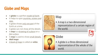
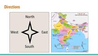
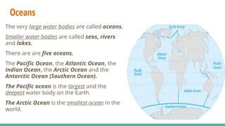
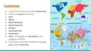
Class 3rd Social Studies
Chapter 2
Knowing our Earth
By Anamika Mishra (PRT)
Social Studies
Globe and Maps
● A globe is a perfect model of Earth.
● It helps to spot countries, oceans and
seas.
● A globe shows only one part of the
Earth at a time.
● A globe can not show all the details.
● A map is a drawing of a place on a
flat surface.
● A map is used to show small details.
● Wall maps
● A book of maps is called an atlas.
Directions
Oceans
The very large water bodies are called oceans.
Smaller water bodies are called seas, rivers
and lakes.
There are are five oceans.
The Pacific Ocean, the Atlantic Ocean, the
Indian Ocean, the Arctic Ocean and the
Antarctic Ocean (Southern Ocean).
The Pacific ocean is the largest and the
deepest water body on the Earth.
The Arctic Ocean is the smallest ocean in the
world.
Quick Revision
1. The _____________ on the map of the world, shows water.
a) Red colour b) blue colour c) green colour
1. The ____________ is the smallest ocean in the world.
a) Pacific Ocean b) Arctic Ocean c) Indian Ocean
1. A _____ is a model of Earth.
a) Map b) Atlas c) Globe
Fill in the blanks-
1. We hang ___________ on the wall.
2. There are ________ oceans.
3. A book of maps is called___________.
4. A _____ is a drawing of a place on a flat surface.
Multiple choice questions-
Continents
● Large land masses are called continents.
● There are seven continents-
● Asia
● Africa
● North America
● South America
● Europe
● Australia and
● Antarctica
● Asia is the largest and Australia is the
smallest continent.
● Continents are further divided into smaller
parts called countries.
Compass
● A compass is used to find directions.
● Looks like a watch.
● The needle of the compass always points
towards the north.
● Sailors use a compass to find ways in oceans.
● No sign boards for directions.

Class 3rd Social Studies Chapter 2 (KNOWING OUR EARTH)

  • 1.
    Class 3rd SocialStudies Chapter 2 Knowing our Earth By Anamika Mishra (PRT) Social Studies
  • 3.
    Globe and Maps ●A globe is a perfect model of Earth. ● It helps to spot countries, oceans and seas. ● A globe shows only one part of the Earth at a time. ● A globe can not show all the details. ● A map is a drawing of a place on a flat surface. ● A map is used to show small details. ● Wall maps ● A book of maps is called an atlas.
  • 4.
  • 5.
    Oceans The very largewater bodies are called oceans. Smaller water bodies are called seas, rivers and lakes. There are are five oceans. The Pacific Ocean, the Atlantic Ocean, the Indian Ocean, the Arctic Ocean and the Antarctic Ocean (Southern Ocean). The Pacific ocean is the largest and the deepest water body on the Earth. The Arctic Ocean is the smallest ocean in the world.
  • 6.
    Quick Revision 1. The_____________ on the map of the world, shows water. a) Red colour b) blue colour c) green colour 1. The ____________ is the smallest ocean in the world. a) Pacific Ocean b) Arctic Ocean c) Indian Ocean 1. A _____ is a model of Earth. a) Map b) Atlas c) Globe Fill in the blanks- 1. We hang ___________ on the wall. 2. There are ________ oceans. 3. A book of maps is called___________. 4. A _____ is a drawing of a place on a flat surface. Multiple choice questions-
  • 7.
    Continents ● Large landmasses are called continents. ● There are seven continents- ● Asia ● Africa ● North America ● South America ● Europe ● Australia and ● Antarctica ● Asia is the largest and Australia is the smallest continent. ● Continents are further divided into smaller parts called countries.
  • 8.
    Compass ● A compassis used to find directions. ● Looks like a watch. ● The needle of the compass always points towards the north. ● Sailors use a compass to find ways in oceans. ● No sign boards for directions.