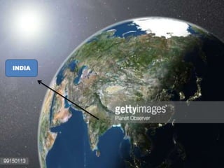
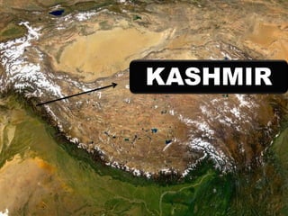
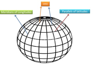
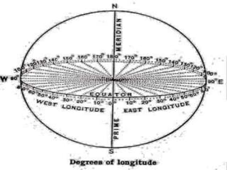
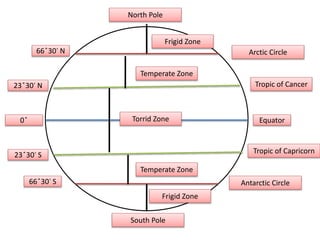
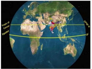
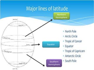
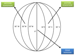
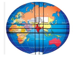
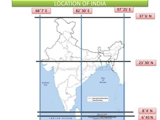
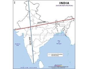
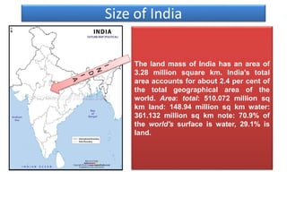
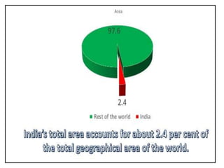
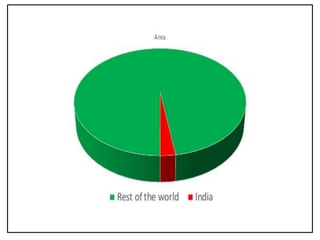
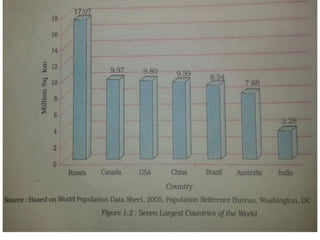
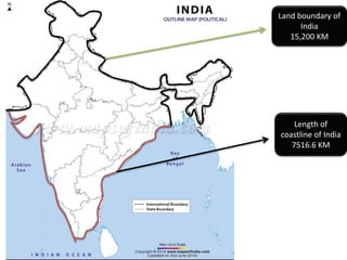
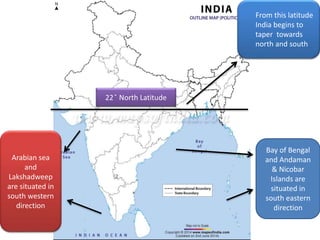
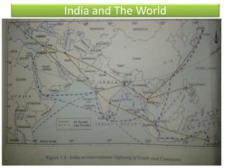
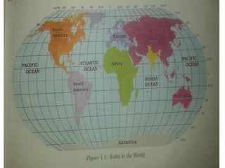
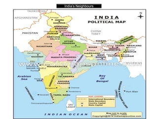
GEOGRAPHY
CLASS: 9TH
(CHAPTER 1) : INDIA-SIZE AND LOCATION
INDIA
KASHMIR
Parallels of latitudesMeridians of Longitudes
GRID
Earth takes four minutes
to rotate from one
longitude to another
Equator
Tropic of Cancer
Tropic of Capricorn
Antarctic Circle
Arctic Circle
0 ̊
66 ̊30̕ N
23 ̊30̕ N
23 ̊30̕ S
66 ̊30̕ S
North Pole
South Pole
Torrid Zone
Temperate Zone
Temperate Zone
Frigid Zone
Frigid Zone
Northern
Hemisphere
Southern
Hemisphere
Equator
0 ̊
10 ̊E 20 ̊ E10 ̊W 30 ̊ E20 ̊W30 ̊ W
EASTERN
HEMISPHERE
WESTERN
HEMISPHERE
PRIME
MERIDIAN
The International Date Line (IDL) is
an imaginary line of longitude on
the Earth's surface located at about
180 degrees east (or west) of the
Greenwich Meridian.
The International Date Line (IDL) is an imaginary line of navigation on
the surface of the Earth that runs from the north pole to the south pole
and demarcates the change of one calendar day to the next. It passes
through the middle of the Pacific Ocean, roughly following the180° line
of longitude but deviating to pass around some territories and island
groups.
In eastern hemisphere there are 180
longitudes and in western hemisphere
there are also 180 longitudes. Therefore
the total number of longitudes are 360.
Earth takes four minutes to rotate from
one longitude to another.
360 Longitudes × 4 Minutes
1440 minutes
1440/60=24 Hours
In this way earth takes 24 hrs to complete
one rotation.
LOCATION OF INDIA
37 ̊6̕ N
8 ̊4̕ N
23 ̊30̕ N
6 ̊45̕N
68 ̊7̕ E 82 ̊30̕ E 97 ̊25̕ E
Size of India
The land mass of India has an area of
3.28 million square km. India’s total
area accounts for about 2.4 per cent of
the total geographical area of the
world. Area: total: 510.072 million sq
km land: 148.94 million sq km water:
361.132 million sq km note: 70.9% of
the world's surface is water, 29.1% is
land.
Land boundary of
India
15,200 KM
Length of
coastline of India
7516.6 KM
22 ̊ North Latitude
From this latitude
India begins to
taper towards
north and south
Bay of Bengal
and Andaman
& Nicobar
Islands are
situated in
south eastern
direction
Arabian sea
and
Lakshadweep
are situated in
south western
direction
India and The World
The Indian landmass has a central
location between the East and the
West Asia. India is a southward
extension of the Asian Continent.
The trans Indian Ocean routes which
connect the countries of Europe in
the West and the countries of East
Asia provide a strategic central
location to India. Note that the
Deccan Peninsula protrudes into the
Indian Ocean, thus helping India to
establish close contact with West
Asia, Africa and Europe from the
western coast and with Southeast
and East Asia from the eastern
coast. No other country has a long
coastline on the Indian Ocean as
India has and indeed, it is India’s
eminent position in the Indian Ocean
which justifies the naming of an
Ocean after it.
India’s contacts with the World have
continued through the ages but her
relationships through the land routes
are much older than her maritime
contacts. The various passes across
the mountains in the north have
provided passages to the ancient
travelers, while the oceans restricted
such interaction for a long time.
These routes have contributed in the
exchange of ideas and commodities
since ancient times. The ideas of the
Upanishads and the Ramayana, the
stories of Panchtantra, the Indian
numerals and the decimal system thus
could reach many parts of the world.
The spices, muslin and other
merchandise were taken from India to
different countries. On the other hand,
the influence of Greek sculpture, and
the architectural styles of dome and
minarets from West Asia can be seen in
different parts of our country.
India’s Neighbours
India occupies an important strategic position in South Asia. India has 29
states and 7 Union Territories. India shares its land boundaries with
Pakistan and Afghanistan in the northwest, China (Tibet), Nepal and
Bhutan in the north and Myanmar and Bangladesh in the east. Our
southern neighbours across the sea consist of the two island countries,
namely Sri Lanka and Maldives. Sri Lanka is separated from India by a
narrow channel of sea formed by the Palk Strait and the Gulf of Mannar
while Maldives Islands are situated to the south of the Lakshadweep
Islands.
THANKS
PRESENTATION PREPARED BY:
SHABIR AHMAD DAR
DPS SRINAGAR
M.SC GEOGRAPHY
PHD, M.SC ZOOLOGY
B.Ed

India size and location

  • 1.
  • 2.
    (CHAPTER 1) :INDIA-SIZE AND LOCATION
  • 3.
  • 4.
  • 5.
  • 7.
    Earth takes fourminutes to rotate from one longitude to another
  • 8.
    Equator Tropic of Cancer Tropicof Capricorn Antarctic Circle Arctic Circle 0 ̊ 66 ̊30̕ N 23 ̊30̕ N 23 ̊30̕ S 66 ̊30̕ S North Pole South Pole Torrid Zone Temperate Zone Temperate Zone Frigid Zone Frigid Zone
  • 10.
  • 11.
    0 ̊ 10 ̊E20 ̊ E10 ̊W 30 ̊ E20 ̊W30 ̊ W EASTERN HEMISPHERE WESTERN HEMISPHERE PRIME MERIDIAN
  • 12.
    The International DateLine (IDL) is an imaginary line of longitude on the Earth's surface located at about 180 degrees east (or west) of the Greenwich Meridian. The International Date Line (IDL) is an imaginary line of navigation on the surface of the Earth that runs from the north pole to the south pole and demarcates the change of one calendar day to the next. It passes through the middle of the Pacific Ocean, roughly following the180° line of longitude but deviating to pass around some territories and island groups.
  • 13.
    In eastern hemispherethere are 180 longitudes and in western hemisphere there are also 180 longitudes. Therefore the total number of longitudes are 360. Earth takes four minutes to rotate from one longitude to another. 360 Longitudes × 4 Minutes 1440 minutes 1440/60=24 Hours In this way earth takes 24 hrs to complete one rotation.
  • 15.
    LOCATION OF INDIA 37̊6̕ N 8 ̊4̕ N 23 ̊30̕ N 6 ̊45̕N 68 ̊7̕ E 82 ̊30̕ E 97 ̊25̕ E
  • 17.
    Size of India Theland mass of India has an area of 3.28 million square km. India’s total area accounts for about 2.4 per cent of the total geographical area of the world. Area: total: 510.072 million sq km land: 148.94 million sq km water: 361.132 million sq km note: 70.9% of the world's surface is water, 29.1% is land.
  • 21.
    Land boundary of India 15,200KM Length of coastline of India 7516.6 KM
  • 22.
    22 ̊ NorthLatitude From this latitude India begins to taper towards north and south Bay of Bengal and Andaman & Nicobar Islands are situated in south eastern direction Arabian sea and Lakshadweep are situated in south western direction
  • 23.
  • 24.
    The Indian landmasshas a central location between the East and the West Asia. India is a southward extension of the Asian Continent. The trans Indian Ocean routes which connect the countries of Europe in the West and the countries of East Asia provide a strategic central location to India. Note that the Deccan Peninsula protrudes into the Indian Ocean, thus helping India to establish close contact with West Asia, Africa and Europe from the western coast and with Southeast and East Asia from the eastern coast. No other country has a long coastline on the Indian Ocean as India has and indeed, it is India’s eminent position in the Indian Ocean which justifies the naming of an Ocean after it. India’s contacts with the World have continued through the ages but her relationships through the land routes are much older than her maritime contacts. The various passes across the mountains in the north have provided passages to the ancient travelers, while the oceans restricted such interaction for a long time. These routes have contributed in the exchange of ideas and commodities since ancient times. The ideas of the Upanishads and the Ramayana, the stories of Panchtantra, the Indian numerals and the decimal system thus could reach many parts of the world. The spices, muslin and other merchandise were taken from India to different countries. On the other hand, the influence of Greek sculpture, and the architectural styles of dome and minarets from West Asia can be seen in different parts of our country.
  • 26.
  • 27.
    India occupies animportant strategic position in South Asia. India has 29 states and 7 Union Territories. India shares its land boundaries with Pakistan and Afghanistan in the northwest, China (Tibet), Nepal and Bhutan in the north and Myanmar and Bangladesh in the east. Our southern neighbours across the sea consist of the two island countries, namely Sri Lanka and Maldives. Sri Lanka is separated from India by a narrow channel of sea formed by the Palk Strait and the Gulf of Mannar while Maldives Islands are situated to the south of the Lakshadweep Islands.
  • 28.
    THANKS PRESENTATION PREPARED BY: SHABIRAHMAD DAR DPS SRINAGAR M.SC GEOGRAPHY PHD, M.SC ZOOLOGY B.Ed