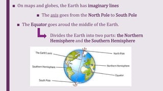
Maps and globes represent the Earth and its features like continents, oceans, rivers, and countries. There are different types of maps including wall maps which are flat, globes which are spherical, and atlases which are books of maps. Maps use lines like the equator and cardinal directions to orient and divide the Earth. The equator divides the Earth into the Northern and Southern Hemispheres, while cardinal directions of north, east, south, and west are shown. Relief maps depict land elevations and physical features while political maps show borders and cities.