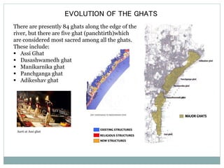
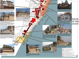
Varanasi is an ancient city located on the banks of the Ganges River in Uttar Pradesh. It has been continuously inhabited for over 2,000 years and is considered one of the holiest places in Hinduism. The document describes Varanasi's history and growth, including its traditional core established in the 2nd century BC, and later developments like the colonial settlement in the 18th century and Benaras Hindu University in 1916. It provides statistical data on Varanasi's population, literacy rates, and administrative divisions. Key features discussed include the 84 ghats along the Ganges used for religious rituals and bathing, and the city's radial and orthogonal street networks within the traditional core.
Varanasi Seminar - History and Development of the Holy City
1. SEMINAR -1
"Varanasi is older than history, older than tradition, even older than legend
and looks twice as old as all of them put together."
-- Mark Twain
2. CONTENT
CITY PROFILE
LOCATION AND LINKAGES
HISTORICAL BACKGROUND
PHYSICAL GROWTH OF CITY
3. LOCATION AND LINKAGES
Varanasi , also known as
Benares or Kashi , is a city on
the banks of the river Gange in
Uttar Pradesh
Varanasi is located 797 km southeast of New Delhi,
320 km southeast of Lucknow, 121 km east of
Allahabad.
Source:census of India 2001&2011
4. ACTIVITIES ON THE GHATS
Due to high concentration of pilgrims and tourists the ghat area is a highly
active and dynamic area. One can see lot of religious, traditional and
commercial activities on the ghats. “Appropriation of space”
Source://www.google.co.in
5. HISTORICAL TIMELINE
2nd CENTURY BC: traditional core of the city is
established.
10-11th CENTURY AD: period of golden age.
12th CENTURY AD: city is brought under Hindu and
Muslim rule.
13th CENTURY AD: city is bought under rule of
Muslim nawabs.
1585 AD: the traditional core is brought under
Akbar’s mughal empire.
1725 AD: the kashiraj dynasty establishes Ramnagar.
1775 AD: british gain political control over the city.
1794 AD: the cantonment is established.
1862 AD: the first railway link between calcutta and
benaras is established.
1916 AD: Benaras Hindu University is established.
1950 AD: the first master plan for the city was
prepared.
1974 AD: Varanasi Development Authority was
formed.
1991 AD: “Draft Master Plan 2001” was prepared.
Traditional
core
ramnagar
Mughal empire
BHU
6. SPATIAL CHARACTERSTICS OF THE
Areas located in the
proximity of the river
assume greater social
significance.
The city’s topography
consists of three
mounds resembling
lord shiva’s trishul.
These are recognized
as three sacred cores.
TRADITIONAL CORE
Multiple foci within
radial structure
Multiple foci within
spatial structure
7. SPATIAL CHARACTERSTICS OF THE
TRADITIONAL CORE
Water bodies Radial street networks
Orthogonal street networks
Superimposition of radial
and orthogonal street
networks
8. Princep’s drawing of
Benaras in 1822
Forests and reefs Water bodies
Flood plains
PHYSICAL GROWTH OF THE CITY
19th century area of 112.26 sq. km)
2011-master plan,area of 144.89 sq. km
9. SIGNIFICANT EVOLUTION FROM 1830-1880
In the later half of the nineteenth century, the most significant change is
the -increase in the pakka mahal which rapidly encroached upon the
kachcha houses.
Also all vacant spaces in the immediate neighbourhood of the Ganga were
filled in by Pakka houses.
The two ill-drained areas, formerly
occupied by the Godaulia Nala and
the Misra Pokhra Jhil in the
south and the Maidagin and
Machhodari tank in the north
disappeared.
The site of the Maidagin tank
gradually came to be replaced by
the Company garden, north
of the present a center of the
city. The Machhodari tank was
drained into the Ganga though an
underground channel.
10. RAMNAGAR
Ramnagar was founded by the Kashiraj dynasty in 1752.
It is located on the eastern bank of the river ganga.
Ramnagar comprises a continuous linear edge of civic
buildings enclosing an avenue.
The built form is generally 2 to 3 stories high.
The civic spine connect the fort at the western end to the
city gate at the eastern end.
Strategic location of ramnagar
Plan of ramnagar
Ramnagar fort
11. COLONIAL SETTLEMENT
The colonial settlement was located in proximity to
river varna, 4miles from the traditional core.
The british had political control over Varanasi from
1775 until 1947.
The settlement comprises of cantonment, a civil
station and administrative quarters.
Each component of the colonial settlement was
located around an independent focus and comprised
of a mix of institutional and residential uses.
The settlement has characteristic wide open spaces.
The buildings are 1 to 2 stories high. Map of colonial settlement
Colonial bunglow
12. BENARAS HINDU UNIVERSITY
The university was founded in 1916.
It is located on the south western banks of the river
ganga.
It is defined by it’s composite semi-circular pattern.
The character is based on forms derived from
western principles and stylized by traditional Indian
motifs.
BHU
Plan of the university
University road
Residential building in the university
13. CONTEMPORARY DEVELOPMENT
The organization principles of the contemporary settlements are based on
formalized zoning codes.
The buildings can be distinguished from one another on the basis of
functional differences.
The housing typologies range from plotted and group housing to squatters.
Residential development
14. EVOLUTION OF THE GHATS
There are presently 84 ghats along the edge of the
river, but there are five ghat (panchtirth)which
are considered most sacred among all the ghats.
These include:
Assi Ghat
Dasashwamedh ghat
Manikarnika ghat
Panchganga ghat
Adikeshav ghat
Aarti at Assi ghat
15. SPATIAL CHARACTERSTICS OF THE
COLONIAL SETTLEMENT
Location of the colonial settlement wrt the
traditional core
Street networks in the colonial settlement
Factors affecting location:
Traditional core considered
“dangerous/unhygenic”
Less investment
Proximity to river
Factors resulting in deformed
street pattern:
Existing features
Topography
“ Green villages “ in london
16. STASTICAL DATA
Location:Longitude 83.0 Latitude:25.20
Geographical
1535 Sq. Km.
Area(2001)
Population (2011) 3,682,194
(1) Male (2011) 1,928,641
(2) Female (2011) 1,753,553
(3) Rural (2001) 1878100
(4) Urban (2001) 1260570
(5) Scheduled Caste 435540
(6) Scheduled Tribes 770
(7) Sex Ratio 909
(8) Population Density 2399 per.sq.km.
Literacy 77.05 %
(1) Male 85.12 %
(2) Female 68.20 %
No. of Tehsil 3
No. of Block 8
No. of Nyay Panchayats 108
No. of Gram Panchayats 702
No. of Villages 1327
(1) Inhabitated 1289
(2) Uninhabitated 38
Town/Group of towns (2001) 4
(1) Nagar Nigam 1
(2) Nagar Palika Parishad 1
(3) Nagar Panchayat 1
(4) Cantonment Board 1
No. of Police Stations 25
(1) Rural 8
(2) Urban 17
Source:census of India(2001&2011)