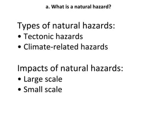
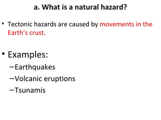
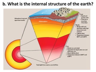
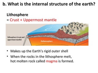
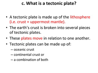
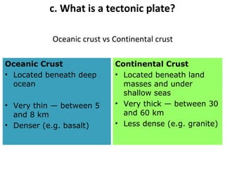
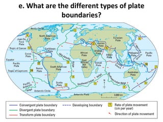
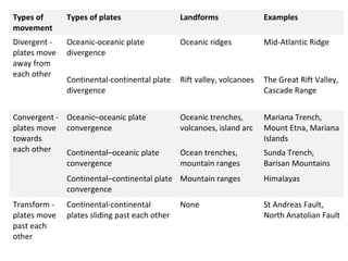
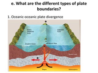
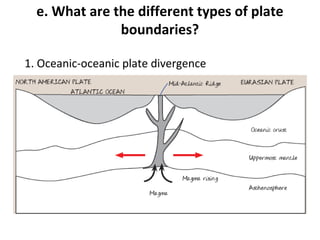
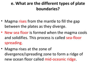
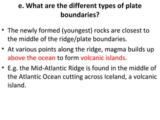
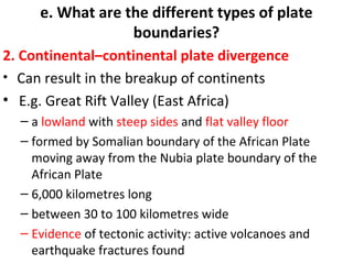
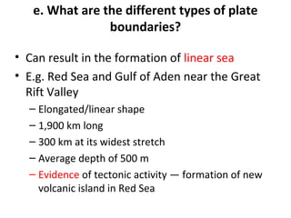
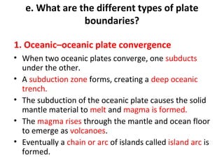
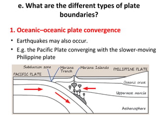
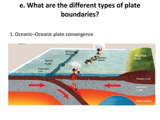
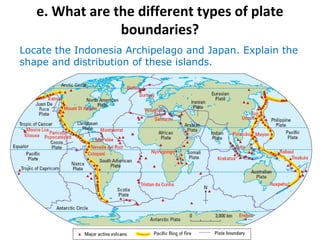
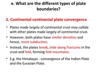
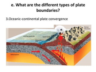
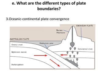
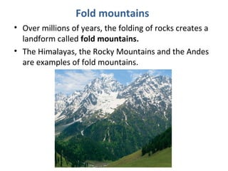
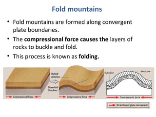
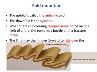
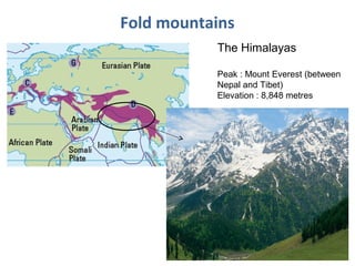
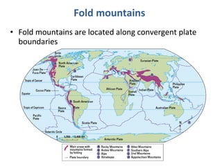
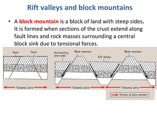
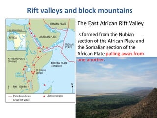
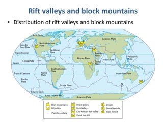
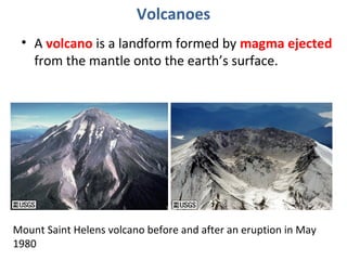
LIVING WITH 
TECTONIC HAZARDS 
a. What is a natural hazard? 
b. What is the internal structure of the Earth? 
c. What is a tectonic plate? 
d. Why do tectonic plates move? 
e. What are the different types of plate 
boundaries?
a. What is a natural hazard? 
• A natural hazard is a natural event that threatens 
human lives and causes damage to property.
a. What is a natural hazard? 
Distribution of natural hazards
a. What is a natural hazard? 
Types of natural hazards: 
• Tectonic hazards 
• Climate-related hazards 
Impacts of natural hazards: 
• Large scale 
• Small scale
a. What is a natural hazard? 
• Tectonic hazards are caused by movements in the 
Earth’s crust. 
• Examples: 
–Earthquakes 
–Volcanic eruptions 
–Tsunamis
b. What is the internal structure of the earth?
b. What is the internal structure of the earth? 
Core 
• Composed mostly of iron and nickel 
• Divided into inner core + outer core 
1. Inner core 
– about 1,200 km thick 
– solid layer 
2. Outer core 
– about 2,100 km thick 
– liquid layer 
• Temperature between 3,000⁰C and 5,000⁰C
b. What is the internal structure of the earth? 
Mantle 
• Mostly solid rock (flows under high temperature and 
pressure) 
• 2,900 km thick 
• Divided into upper mantle + lower mantle 
Upper mantle 
– a layer of solid rock + asthenosphere 
– below uppermost mantle 
– rocks close to melting point, easily deformed 
• Temperature between 800⁰C and 3,000⁰C
b. What is the internal structure of the earth? 
Crust 
• Outermost layer on which we live 
• Oceanic crust is found beneath oceans 
• Continental crust is found beneath the continents 
• Thickness ranges from a few km to more than 70 km
b. What is the internal structure of the earth? 
Lithosphere 
= Crust + Uppermost mantle 
• Makes up the Earth’s rigid outer shell 
• When the rocks in the lithosphere melt, 
hot molten rock called magma is formed.
c. What is a tectonic plate? 
• A tectonic plate is made up of the lithosphere 
(i.e. crust + uppermost mantle). 
• The earth’s crust is broken into several pieces 
of tectonic plates. 
• These plates move in relation to one another. 
• Tectonic plates can be made up of: 
– oceanic crust 
– continental crust or 
– a combination of both
c. What is a tectonic plate? 
Oceanic crust vs Continental crust 
Oceanic Crust 
• Located beneath deep 
ocean 
• Very thin — between 5 
and 8 km 
• Denser (e.g. basalt) 
Continental Crust 
• Located beneath land 
masses and under 
shallow seas 
• Very thick — between 30 
and 60 km 
• Less dense (e.g. granite)
d. Why do tectonic plates move? 
1. Convection currents 
•Convection currents are movements of heat within the 
mantle. 
•Material in the mantle is heated by the core. 
•This causes convection currents in the molten mantle 
material. 
•Mantle expands, rises and spreads out beneath the plates. 
•Plates are dragged along and move away from each other. 
•Subsequently, the hot molten mantle cools slightly and sinks, 
pulling the plates along 
•Hence plates move towards each other. 
•The sinking mantle material heats up again as it nears the 
core and the whole process repeats.
d. Why do tectonic plates move? 
Plates moving away from each other 
Ocean floor 
Plates 
moving 
towards 
each 
other 
Plates 
Plates 
moving 
towards 
each other 
Tectonic plates float on molten mantle, driven by heat 
energy/convection currents
d. Why do tectonic plates move? 
2. Slab-pull force 
• This occurs when an oceanic plate (denser) subducts 
under a less dense plate and pulls the rest of the 
plate along. 
• The subducting plate drives the downward-moving 
portion of convection currents. 
• While mantle material away from the subduction 
zone drives the rising portion of convection currents.
d. Why do tectonic plates move? 
Changing positions of the earth’s continents 
• Plate movements have altered the distribution of 
the earth’s land masses over several hundred 
million years.
e. What are the different types of plate 
boundaries?
Types of 
movement 
Types of plates Landforms Examples 
Divergent - 
plates move 
away from 
each other 
Oceanic-oceanic plate 
divergence 
Oceanic ridges Mid-Atlantic Ridge 
Continental-continental plate 
divergence 
Rift valley, volcanoes The Great Rift Valley, 
Cascade Range 
Convergent - 
plates move 
towards 
each other 
Oceanic–oceanic plate 
convergence 
Oceanic trenches, 
volcanoes, island arc 
Mariana Trench, 
Mount Etna, Mariana 
Islands 
Continental–oceanic plate 
convergence 
Ocean trenches, 
mountain ranges 
Sunda Trench, 
Barisan Mountains 
Continental–continental plate 
convergence 
Mountain ranges Himalayas 
Transform - 
plates move 
past each 
other 
Continental-continental 
plates sliding past each other 
None St Andreas Fault, 
North Anatolian Fault
e. What are the different types of plate 
boundaries? 
1. Oceanic-oceanic plate divergence
e. What are the different types of plate 
boundaries? 
1. Oceanic-oceanic plate divergence
e. What are the different types of plate 
boundaries? 
• Magma rises from the mantle to fill the gap 
between the plates as they diverge. 
• New sea floor is formed when the magma cools 
and solidifies. This process is called sea-floor 
spreading. 
• Magma rises at the zone of 
divergence/spreading zone to form a ridge of 
new ocean floor called mid-oceanic ridge.
e. What are the different types of plate 
boundaries? 
• The newly formed (youngest) rocks are closest to 
the middle of the ridge/plate boundaries. 
• At various points along the ridge, magma builds up 
above the ocean to form volcanic islands. 
• E.g. the Mid-Atlantic Ridge is found in the middle of 
the Atlantic Ocean cutting across Iceland, a volcanic 
island.
e. What are the different types of plate 
boundaries? 
2. Continental–continental plate divergence 
• Can result in the breakup of continents 
• E.g. Great Rift Valley (East Africa) 
– a lowland with steep sides and flat valley floor 
– formed by Somalian boundary of the African Plate 
moving away from the Nubia plate boundary of the 
African Plate 
– 6,000 kilometres long 
– between 30 to 100 kilometres wide 
– Evidence of tectonic activity: active volcanoes and 
earthquake fractures found
e. What are the different types of plate 
boundaries? 
• Can result in the formation of linear sea 
• E.g. Red Sea and Gulf of Aden near the Great 
Rift Valley 
– Elongated/linear shape 
– 1,900 km long 
– 300 km at its widest stretch 
– Average depth of 500 m 
– Evidence of tectonic activity — formation of new 
volcanic island in Red Sea
e. What are the different types of plate 
boundaries? 
1. Oceanic–oceanic plate convergence 
• When two oceanic plates converge, one subducts 
under the other. 
• A subduction zone forms, creating a deep oceanic 
trench. 
• The subduction of the oceanic plate causes the solid 
mantle material to melt and magma is formed. 
• The magma rises through the mantle and ocean floor 
to emerge as volcanoes. 
• Eventually a chain or arc of islands called island arc is 
formed.
e. What are the different types of plate 
boundaries? 
1. Oceanic–oceanic plate convergence 
• Earthquakes may also occur. 
• E.g. the Pacific Plate converging with the slower-moving 
Philippine plate
e. What are the different types of plate 
boundaries? 
1. Oceanic–Oceanic plate convergence
e. What are the different types of plate 
boundaries? 
Locate the Indonesia Archipelago and Japan. Explain the 
shape and distribution of these islands.
e. What are the different types of plate 
boundaries? 
2. Continental-continental plate convergence 
• Plates made largely of continental crust may collide 
with other plates made largely of continental crust. 
• However, both plates have similar densities and 
hence, resist subduction. 
• Instead, the plates break, slide along fractures in the 
crust and fold, forming fold mountains. 
• E.g. the Himalayas - convergence of the Indian Plate 
and the Eurasian Plate.
e. What are the different types of plate 
boundaries? 
E.g. the Himalayas 
Continental crust 
Continental crust 
Himalayas 
Tibetan 
Plateau 
Uppermost mantle 
Asthenosphere 
EURASIAN 
PLATE 
INDIAN 
PLATE
e. What are the different types of plate 
boundaries? 
3.Oceanic-continental plate convergence 
• When an oceanic plate meets a continental plate, the 
denser oceanic plate subducts under the less dense 
continental plate. 
• A subduction zone forms, creating a deep oceanic 
trench along the plate boundary. 
• The subduction of the continental plate causes the 
soild mantle material to melt and magma is formed.
e. What are the different types of plate 
boundaries? 
3.Oceanic-continental plate convergence 
• The magma rises through the mantle and crust to 
emerge as volcanoes on land. 
• The edge of thick continental plate buckles to form 
fold mountains. 
• Earthquakes may also occur. 
• E.g. the Australian Plate subducting under a section 
of the Eurasian Plate near Sumatra formed the Sunda 
Trench.
e. What are the different types of plate 
boundaries? 
3.Oceanic-continental plate convergence
e. What are the different types of plate 
boundaries? 
3.Oceanic-continental plate convergence
e. What are the different types of plate 
boundaries? 
Transform plate boundaries 
• Plates slide past each other. 
• As they do so, tremendous stress builds up. 
• This stress is eventually released, often as a violent 
earthquake. 
• E.g. San Andreas Fault, United States of America & 
North Anatolian Fault, Turkey
e. What are the different types of plate 
boundaries? 
Transform plate boundaries
e. What are the different types of plate 
boundaries? 
E.g. San Andreas Fault, United States of America 
• In 1906, an earthquake occurred in San 
Francisco, southern California between the 
Pacific Plate and the North American Plate. 
– This caused several hundred kilometres of 
North American Plate to move an average of 
2.5 m, 
– and at one point almost 7 m all in less than 1 
minute.
e. What are the different types of plate 
boundaries? 
E.g. San Andreas Fault, USA
e. What are the different types of plate 
boundaries? 
E.g. North Anatolian Fault, Turkey 
How would the plate movement affect the two 
cities shown in time to come?
a. Why are different landforms found at 
different plate boundaries and how are they 
formed? 
• The movement of plates at different 
plate boundaries can result in various 
landforms such as: 
- Fold mountains 
- Rift valleys and block mountains 
- Volcanoes
Fold mountains 
• Over millions of years, the folding of rocks creates a 
landform called fold mountains. 
• The Himalayas, the Rocky Mountains and the Andes 
are examples of fold mountains.
Fold mountains 
• Fold mountains are formed along convergent 
plate boundaries. 
• The compressional force causes the layers of 
rocks to buckle and fold. 
• This process is known as folding.
Fold mountains 
• The upfold is called the anticline and 
• The downfold is the syncline. 
• When there is increasing compressional force on one 
limb of a fold, the rocks may buckle until a fracture 
forms. 
• The limb may then move forward to ride over the 
other limb
Fold mountains 
The Himalayas 
Peak : Mount Everest (between 
Nepal and Tibet) 
Elevation : 8,848 metres
Fold mountains 
• Fold mountains are located along convergent plate 
boundaries
Rift valleys and block mountains 
• Rift valleys and block mountains are formed at 
divergent plate boundaries.
Rift valleys and block mountains 
• A fault is a fracture in the rocks along which 
the rocks are displaced. 
• The tensional forces result in parts of the 
crust being fractured. 
• This process is called faulting.
Rift valleys and block mountains 
• A rift valley is a valley with steep sides formed along 
fault lines. 
• E.g. East African Rift Valley
Rift valleys and block mountains 
• A block mountain is a block of land with steep sides. 
It is formed when sections of the crust extend along 
fault lines and rock masses surrounding a central 
block sink due to tensional forces.
Rift valleys and block mountains 
The East African Rift Valley 
Is formed from the Nubian 
section of the African Plate and 
the Somalian section of the 
African Plate pulling away from 
one another.
Rift valleys and block mountains 
• Distribution of rift valleys and block mountains
Volcanoes 
• A volcano is a landform formed by magma ejected 
from the mantle onto the earth’s surface. 
Mount Saint Helens volcano before and after an eruption in May 
1980
Volcanoes 
• Magma is molten rock found below the earth’s 
surface. 
• Parts of a Volcano 
- magma chamber 
- vents 
• Magma that is ejected onto the surface is known 
as lava.
Volcanoes 
Formation, structure of, and features of a volcano
Volcanoes 
Shapes and sizes of volcanoes 
• Volcanoes vary in shapes and sizes due to the 
characteristics of the lava. 
• Viscosity refers to the stickiness of the lava 
• The most common types of volcanoes are: 
- Shield volcanoes; and 
- Stratovolcanoes
Volcanoes 
Shield volcanoes 
• Shield volcanoes have gently sloping sides and a 
broad summit 
• E.g. Mount Washington, United States of America
Volcanoes 
Stratovolcanoes 
• Stratovolcanoes develop from successive eruptions of 
lava and ash. 
• E.g. Mount Mayon, Philippines
Volcanoes 
Distribution of earth’s major active volcanoes
b. What phenomena are found at plate 
boundaries and how are they formed? 
• An earthquake is a vibration in the earth’s crust caused by the 
sudden release of stored energy in the rocks found along 
fault lines.
Earthquakes 
• Apart from its magnitude, the extent of damage 
caused by an earthquake may vary based on other 
factors: 
- Population density 
- time of occurrence 
- level of preparedness 
- distance from the epicentre 
- type of soil
Earthquakes 
The distribution of the earth’s major earthquakes
Earthquakes 
Hazards associated with living in earthquakes zones 
- Threat of tsunamis 
- Disruption of services 
- Fires 
- Landslides 
- Destruction of properties 
- Destruction of infrastructure 
- Loss of lives
Hazards associated with earthquakes 
Threat of tsunamis 
• Tsunami refers to an usually large sea wave. 
• Tsunamis may be formed by: 
- The movement of the sea floor during a large earthquake 
at subduction zones; 
- An underwater volcanic eruption; 
- An underwater landslide; and 
- A landslide above sea level which causes materials to 
plunge into the water.
Hazards associated with earthquakes
Hazards associated with earthquakes 
Disruption of services 
• An earthquake can disrupt services such as the 
supply of electricity, gas and water. 
• The earthquake in Kobe, Japan, in 1995 disrupted 
electricity, gas and water supplies to about a million 
of Kobe city’s 1.4 million residents. 
Fire 
- Earthquakes may rupture gas pipes and this can provide 
fuel to start fires. 
- For example, the earthquake in Kobe, Japan, in 1995 
caused extensive fires.
Hazards associated with earthquakes 
Landslides 
• Landslides are rapid downslope movements of soil, 
rock and vegetation. 
• Mudflows may also occur when there is heavy 
rainfall. 
Destruction of properties 
• Earthquakes can cause destruction to many homes. 
• People may be without homes after the disaster.
Hazards associated with earthquakes 
Loss of lives 
• Earthquakes and their associated hazards often 
threaten the lives of those living in earthquake zones. 
Destruction of infrastructure 
• Earthquakes may cause cracks to form in 
infrastructure such as roads and bridges. 
• Transportation can be disrupted as it is unsafe to use 
the damaged roads.
Hazards associated with earthquakes
b. What phenomena are found at plate 
boundaries and how are they formed? 
Volcanic eruptions 
- Occurs on land occur on the sea floor. 
Active, dormant or extinct 
• Active volcanoes refers to volcanoes which are currently 
erupting or are expected to erupt in the future. 
• Dormant volcanoes are currently inactive but may erupt 
in the near future. 
• Extinct volcanoes refers to volcanoes without current 
seismic activity
Volcanic eruptions 
Risks of living near volcanic areas 
Some of the risks associated with living near volcanic 
areas include: 
• Destruction by volcanic materials 
• Landslides 
• Pollution 
• Effects on weather
Volcanic eruptions 
Destruction by volcanic materials 
• Volcanic materials can lead to widespread damage of 
property. 
Landslides 
• Landslides can occur due to the structural collapse of a 
volcanic cone. 
• Obstruct the flow of rivers which causes floods, 
• block roads, and 
• bury villages and farmlands.
Volcanic eruptions 
Pollution 
• Ash particles may block sunlight, suffocate crops, and 
cause severe respiratory problems for people and 
animals. 
• Release of gases may be harmful to people.
Volcanic eruptions
Volcanic eruptions 
Effects on weather 
• Sulphur dioxide released from volcanic eruptions 
has impacts on the environment 
• It may react with water vapour and other 
chemicals in the atmosphere to form sulphur-based 
particles. 
• These particles reflect the sun’s energy back into 
space and temporarily cool the earth for periods 
of time.
Volcanic eruptions 
Benefits of living near volcanic areas 
• Fertile volcanic soil 
• Building materials, and precious stones and 
materials 
• Tourism 
• Geothermal energy
Volcanic eruptions 
Tourism 
• Volcanic areas offer a variety of activities for 
tourists to engage in. 
• The ruins of Pompeii, Italy, is one such example. 
Pompeii was partially 
destroyed and buried 
under 4 to 6 m (13 to 20 
ft) of ash and pumice in 
the eruption of Mount 
Vesuvius in CE 79.
Volcanic eruptions 
Geothermal energy 
• Geothermal energy is derived from the heat in the 
earth’s crust. 
• The hot water or steam can be harnessed to produce 
electricity.
Volcanic eruptions 
Fertile volcanic soil 
• Lava and ash from the volcanic eruptions break down 
to form fertile volcanic soils. 
• Favourable to agriculture 
Precious stones and minerals, building materials 
• Volcanic rocks can be rich in precious stones and 
minerals. 
• These resources can only be from a volcanic area after 
millions of years. 
• An example is diamond.

Chapter 1 gateway 123 combined students

  • 1.
    LIVING WITH TECTONICHAZARDS a. What is a natural hazard? b. What is the internal structure of the Earth? c. What is a tectonic plate? d. Why do tectonic plates move? e. What are the different types of plate boundaries?
  • 2.
    a. What isa natural hazard? • A natural hazard is a natural event that threatens human lives and causes damage to property.
  • 3.
    a. What isa natural hazard? Distribution of natural hazards
  • 4.
    a. What isa natural hazard? Types of natural hazards: • Tectonic hazards • Climate-related hazards Impacts of natural hazards: • Large scale • Small scale
  • 5.
    a. What isa natural hazard? • Tectonic hazards are caused by movements in the Earth’s crust. • Examples: –Earthquakes –Volcanic eruptions –Tsunamis
  • 6.
    b. What isthe internal structure of the earth?
  • 7.
    b. What isthe internal structure of the earth? Core • Composed mostly of iron and nickel • Divided into inner core + outer core 1. Inner core – about 1,200 km thick – solid layer 2. Outer core – about 2,100 km thick – liquid layer • Temperature between 3,000⁰C and 5,000⁰C
  • 8.
    b. What isthe internal structure of the earth? Mantle • Mostly solid rock (flows under high temperature and pressure) • 2,900 km thick • Divided into upper mantle + lower mantle Upper mantle – a layer of solid rock + asthenosphere – below uppermost mantle – rocks close to melting point, easily deformed • Temperature between 800⁰C and 3,000⁰C
  • 9.
    b. What isthe internal structure of the earth? Crust • Outermost layer on which we live • Oceanic crust is found beneath oceans • Continental crust is found beneath the continents • Thickness ranges from a few km to more than 70 km
  • 10.
    b. What isthe internal structure of the earth? Lithosphere = Crust + Uppermost mantle • Makes up the Earth’s rigid outer shell • When the rocks in the lithosphere melt, hot molten rock called magma is formed.
  • 11.
    c. What isa tectonic plate? • A tectonic plate is made up of the lithosphere (i.e. crust + uppermost mantle). • The earth’s crust is broken into several pieces of tectonic plates. • These plates move in relation to one another. • Tectonic plates can be made up of: – oceanic crust – continental crust or – a combination of both
  • 12.
    c. What isa tectonic plate? Oceanic crust vs Continental crust Oceanic Crust • Located beneath deep ocean • Very thin — between 5 and 8 km • Denser (e.g. basalt) Continental Crust • Located beneath land masses and under shallow seas • Very thick — between 30 and 60 km • Less dense (e.g. granite)
  • 13.
    d. Why dotectonic plates move? 1. Convection currents •Convection currents are movements of heat within the mantle. •Material in the mantle is heated by the core. •This causes convection currents in the molten mantle material. •Mantle expands, rises and spreads out beneath the plates. •Plates are dragged along and move away from each other. •Subsequently, the hot molten mantle cools slightly and sinks, pulling the plates along •Hence plates move towards each other. •The sinking mantle material heats up again as it nears the core and the whole process repeats.
  • 14.
    d. Why dotectonic plates move? Plates moving away from each other Ocean floor Plates moving towards each other Plates Plates moving towards each other Tectonic plates float on molten mantle, driven by heat energy/convection currents
  • 15.
    d. Why dotectonic plates move? 2. Slab-pull force • This occurs when an oceanic plate (denser) subducts under a less dense plate and pulls the rest of the plate along. • The subducting plate drives the downward-moving portion of convection currents. • While mantle material away from the subduction zone drives the rising portion of convection currents.
  • 16.
    d. Why dotectonic plates move? Changing positions of the earth’s continents • Plate movements have altered the distribution of the earth’s land masses over several hundred million years.
  • 17.
    e. What arethe different types of plate boundaries?
  • 18.
    Types of movement Types of plates Landforms Examples Divergent - plates move away from each other Oceanic-oceanic plate divergence Oceanic ridges Mid-Atlantic Ridge Continental-continental plate divergence Rift valley, volcanoes The Great Rift Valley, Cascade Range Convergent - plates move towards each other Oceanic–oceanic plate convergence Oceanic trenches, volcanoes, island arc Mariana Trench, Mount Etna, Mariana Islands Continental–oceanic plate convergence Ocean trenches, mountain ranges Sunda Trench, Barisan Mountains Continental–continental plate convergence Mountain ranges Himalayas Transform - plates move past each other Continental-continental plates sliding past each other None St Andreas Fault, North Anatolian Fault
  • 19.
    e. What arethe different types of plate boundaries? 1. Oceanic-oceanic plate divergence
  • 20.
    e. What arethe different types of plate boundaries? 1. Oceanic-oceanic plate divergence
  • 21.
    e. What arethe different types of plate boundaries? • Magma rises from the mantle to fill the gap between the plates as they diverge. • New sea floor is formed when the magma cools and solidifies. This process is called sea-floor spreading. • Magma rises at the zone of divergence/spreading zone to form a ridge of new ocean floor called mid-oceanic ridge.
  • 22.
    e. What arethe different types of plate boundaries? • The newly formed (youngest) rocks are closest to the middle of the ridge/plate boundaries. • At various points along the ridge, magma builds up above the ocean to form volcanic islands. • E.g. the Mid-Atlantic Ridge is found in the middle of the Atlantic Ocean cutting across Iceland, a volcanic island.
  • 23.
    e. What arethe different types of plate boundaries? 2. Continental–continental plate divergence • Can result in the breakup of continents • E.g. Great Rift Valley (East Africa) – a lowland with steep sides and flat valley floor – formed by Somalian boundary of the African Plate moving away from the Nubia plate boundary of the African Plate – 6,000 kilometres long – between 30 to 100 kilometres wide – Evidence of tectonic activity: active volcanoes and earthquake fractures found
  • 24.
    e. What arethe different types of plate boundaries? • Can result in the formation of linear sea • E.g. Red Sea and Gulf of Aden near the Great Rift Valley – Elongated/linear shape – 1,900 km long – 300 km at its widest stretch – Average depth of 500 m – Evidence of tectonic activity — formation of new volcanic island in Red Sea
  • 25.
    e. What arethe different types of plate boundaries? 1. Oceanic–oceanic plate convergence • When two oceanic plates converge, one subducts under the other. • A subduction zone forms, creating a deep oceanic trench. • The subduction of the oceanic plate causes the solid mantle material to melt and magma is formed. • The magma rises through the mantle and ocean floor to emerge as volcanoes. • Eventually a chain or arc of islands called island arc is formed.
  • 26.
    e. What arethe different types of plate boundaries? 1. Oceanic–oceanic plate convergence • Earthquakes may also occur. • E.g. the Pacific Plate converging with the slower-moving Philippine plate
  • 27.
    e. What arethe different types of plate boundaries? 1. Oceanic–Oceanic plate convergence
  • 28.
    e. What arethe different types of plate boundaries? Locate the Indonesia Archipelago and Japan. Explain the shape and distribution of these islands.
  • 29.
    e. What arethe different types of plate boundaries? 2. Continental-continental plate convergence • Plates made largely of continental crust may collide with other plates made largely of continental crust. • However, both plates have similar densities and hence, resist subduction. • Instead, the plates break, slide along fractures in the crust and fold, forming fold mountains. • E.g. the Himalayas - convergence of the Indian Plate and the Eurasian Plate.
  • 30.
    e. What arethe different types of plate boundaries? E.g. the Himalayas Continental crust Continental crust Himalayas Tibetan Plateau Uppermost mantle Asthenosphere EURASIAN PLATE INDIAN PLATE
  • 31.
    e. What arethe different types of plate boundaries? 3.Oceanic-continental plate convergence • When an oceanic plate meets a continental plate, the denser oceanic plate subducts under the less dense continental plate. • A subduction zone forms, creating a deep oceanic trench along the plate boundary. • The subduction of the continental plate causes the soild mantle material to melt and magma is formed.
  • 32.
    e. What arethe different types of plate boundaries? 3.Oceanic-continental plate convergence • The magma rises through the mantle and crust to emerge as volcanoes on land. • The edge of thick continental plate buckles to form fold mountains. • Earthquakes may also occur. • E.g. the Australian Plate subducting under a section of the Eurasian Plate near Sumatra formed the Sunda Trench.
  • 33.
    e. What arethe different types of plate boundaries? 3.Oceanic-continental plate convergence
  • 34.
    e. What arethe different types of plate boundaries? 3.Oceanic-continental plate convergence
  • 35.
    e. What arethe different types of plate boundaries? Transform plate boundaries • Plates slide past each other. • As they do so, tremendous stress builds up. • This stress is eventually released, often as a violent earthquake. • E.g. San Andreas Fault, United States of America & North Anatolian Fault, Turkey
  • 36.
    e. What arethe different types of plate boundaries? Transform plate boundaries
  • 37.
    e. What arethe different types of plate boundaries? E.g. San Andreas Fault, United States of America • In 1906, an earthquake occurred in San Francisco, southern California between the Pacific Plate and the North American Plate. – This caused several hundred kilometres of North American Plate to move an average of 2.5 m, – and at one point almost 7 m all in less than 1 minute.
  • 38.
    e. What arethe different types of plate boundaries? E.g. San Andreas Fault, USA
  • 39.
    e. What arethe different types of plate boundaries? E.g. North Anatolian Fault, Turkey How would the plate movement affect the two cities shown in time to come?
  • 40.
    a. Why aredifferent landforms found at different plate boundaries and how are they formed? • The movement of plates at different plate boundaries can result in various landforms such as: - Fold mountains - Rift valleys and block mountains - Volcanoes
  • 41.
    Fold mountains •Over millions of years, the folding of rocks creates a landform called fold mountains. • The Himalayas, the Rocky Mountains and the Andes are examples of fold mountains.
  • 42.
    Fold mountains •Fold mountains are formed along convergent plate boundaries. • The compressional force causes the layers of rocks to buckle and fold. • This process is known as folding.
  • 43.
    Fold mountains •The upfold is called the anticline and • The downfold is the syncline. • When there is increasing compressional force on one limb of a fold, the rocks may buckle until a fracture forms. • The limb may then move forward to ride over the other limb
  • 44.
    Fold mountains TheHimalayas Peak : Mount Everest (between Nepal and Tibet) Elevation : 8,848 metres
  • 45.
    Fold mountains •Fold mountains are located along convergent plate boundaries
  • 46.
    Rift valleys andblock mountains • Rift valleys and block mountains are formed at divergent plate boundaries.
  • 47.
    Rift valleys andblock mountains • A fault is a fracture in the rocks along which the rocks are displaced. • The tensional forces result in parts of the crust being fractured. • This process is called faulting.
  • 48.
    Rift valleys andblock mountains • A rift valley is a valley with steep sides formed along fault lines. • E.g. East African Rift Valley
  • 49.
    Rift valleys andblock mountains • A block mountain is a block of land with steep sides. It is formed when sections of the crust extend along fault lines and rock masses surrounding a central block sink due to tensional forces.
  • 50.
    Rift valleys andblock mountains The East African Rift Valley Is formed from the Nubian section of the African Plate and the Somalian section of the African Plate pulling away from one another.
  • 51.
    Rift valleys andblock mountains • Distribution of rift valleys and block mountains
  • 52.
    Volcanoes • Avolcano is a landform formed by magma ejected from the mantle onto the earth’s surface. Mount Saint Helens volcano before and after an eruption in May 1980
  • 53.
    Volcanoes • Magmais molten rock found below the earth’s surface. • Parts of a Volcano - magma chamber - vents • Magma that is ejected onto the surface is known as lava.
  • 54.
    Volcanoes Formation, structureof, and features of a volcano
  • 55.
    Volcanoes Shapes andsizes of volcanoes • Volcanoes vary in shapes and sizes due to the characteristics of the lava. • Viscosity refers to the stickiness of the lava • The most common types of volcanoes are: - Shield volcanoes; and - Stratovolcanoes
  • 56.
    Volcanoes Shield volcanoes • Shield volcanoes have gently sloping sides and a broad summit • E.g. Mount Washington, United States of America
  • 57.
    Volcanoes Stratovolcanoes •Stratovolcanoes develop from successive eruptions of lava and ash. • E.g. Mount Mayon, Philippines
  • 58.
    Volcanoes Distribution ofearth’s major active volcanoes
  • 59.
    b. What phenomenaare found at plate boundaries and how are they formed? • An earthquake is a vibration in the earth’s crust caused by the sudden release of stored energy in the rocks found along fault lines.
  • 60.
    Earthquakes • Apartfrom its magnitude, the extent of damage caused by an earthquake may vary based on other factors: - Population density - time of occurrence - level of preparedness - distance from the epicentre - type of soil
  • 61.
    Earthquakes The distributionof the earth’s major earthquakes
  • 62.
    Earthquakes Hazards associatedwith living in earthquakes zones - Threat of tsunamis - Disruption of services - Fires - Landslides - Destruction of properties - Destruction of infrastructure - Loss of lives
  • 63.
    Hazards associated withearthquakes Threat of tsunamis • Tsunami refers to an usually large sea wave. • Tsunamis may be formed by: - The movement of the sea floor during a large earthquake at subduction zones; - An underwater volcanic eruption; - An underwater landslide; and - A landslide above sea level which causes materials to plunge into the water.
  • 64.
  • 65.
    Hazards associated withearthquakes Disruption of services • An earthquake can disrupt services such as the supply of electricity, gas and water. • The earthquake in Kobe, Japan, in 1995 disrupted electricity, gas and water supplies to about a million of Kobe city’s 1.4 million residents. Fire - Earthquakes may rupture gas pipes and this can provide fuel to start fires. - For example, the earthquake in Kobe, Japan, in 1995 caused extensive fires.
  • 66.
    Hazards associated withearthquakes Landslides • Landslides are rapid downslope movements of soil, rock and vegetation. • Mudflows may also occur when there is heavy rainfall. Destruction of properties • Earthquakes can cause destruction to many homes. • People may be without homes after the disaster.
  • 67.
    Hazards associated withearthquakes Loss of lives • Earthquakes and their associated hazards often threaten the lives of those living in earthquake zones. Destruction of infrastructure • Earthquakes may cause cracks to form in infrastructure such as roads and bridges. • Transportation can be disrupted as it is unsafe to use the damaged roads.
  • 68.
  • 69.
    b. What phenomenaare found at plate boundaries and how are they formed? Volcanic eruptions - Occurs on land occur on the sea floor. Active, dormant or extinct • Active volcanoes refers to volcanoes which are currently erupting or are expected to erupt in the future. • Dormant volcanoes are currently inactive but may erupt in the near future. • Extinct volcanoes refers to volcanoes without current seismic activity
  • 70.
    Volcanic eruptions Risksof living near volcanic areas Some of the risks associated with living near volcanic areas include: • Destruction by volcanic materials • Landslides • Pollution • Effects on weather
  • 71.
    Volcanic eruptions Destructionby volcanic materials • Volcanic materials can lead to widespread damage of property. Landslides • Landslides can occur due to the structural collapse of a volcanic cone. • Obstruct the flow of rivers which causes floods, • block roads, and • bury villages and farmlands.
  • 72.
    Volcanic eruptions Pollution • Ash particles may block sunlight, suffocate crops, and cause severe respiratory problems for people and animals. • Release of gases may be harmful to people.
  • 73.
  • 74.
    Volcanic eruptions Effectson weather • Sulphur dioxide released from volcanic eruptions has impacts on the environment • It may react with water vapour and other chemicals in the atmosphere to form sulphur-based particles. • These particles reflect the sun’s energy back into space and temporarily cool the earth for periods of time.
  • 75.
    Volcanic eruptions Benefitsof living near volcanic areas • Fertile volcanic soil • Building materials, and precious stones and materials • Tourism • Geothermal energy
  • 76.
    Volcanic eruptions Tourism • Volcanic areas offer a variety of activities for tourists to engage in. • The ruins of Pompeii, Italy, is one such example. Pompeii was partially destroyed and buried under 4 to 6 m (13 to 20 ft) of ash and pumice in the eruption of Mount Vesuvius in CE 79.
  • 77.
    Volcanic eruptions Geothermalenergy • Geothermal energy is derived from the heat in the earth’s crust. • The hot water or steam can be harnessed to produce electricity.
  • 78.
    Volcanic eruptions Fertilevolcanic soil • Lava and ash from the volcanic eruptions break down to form fertile volcanic soils. • Favourable to agriculture Precious stones and minerals, building materials • Volcanic rocks can be rich in precious stones and minerals. • These resources can only be from a volcanic area after millions of years. • An example is diamond.

Editor's Notes

  • #3 Suggested activity: Ask students to read the article on http://www.channelnewsasia.com/stories/singaporelocalnews/view/337625/1/.html. Prompt them to explain if the incident is a natural hazard.
  • #11 Suggested activity Recap the internal structure of the earth with students with the website: http://www.learner.org/interactives/dynamicearth/structure.html
  • #14 Suggested activity: Demonstrate convection currents with the video: http://www.youtube.com/watch?v=PdWYBAOqHrk&feature=fvwrel
  • #17 Suggested activity: Let students watch a video on the changing positions of the earth’s continents: http://www.youtube.com/watch?v=WaUk94AdXPA
  • #20 Suggested activity: Let students watch a video on seafloor spreading: http://earthguide.ucsd.edu/eoc/teachers/t_tectonics/p_paleomag.html An example of a volcanic island formed from oceanic-oceanic plate divergence is Iceland. Let students watch a video on it: http://www.youtube.com/watch?v=_rG6q2Npw8Y&feature=related
  • #25 Suggested activity: For Express students Let students learn more about the Red Sea and Gulf of Aden from: http://gln.dcccd.edu/Geology_Demo/content/Lesson1/GEO01-20.swf
  • #29 For Express students
  • #31 Suggested activity: Let students watch a video on continental-continental plate convergence: http://www.youtube.com/watch?v=ngV66m00UvU&feature=related
  • #38 Suggested activity Let students learn more by visiting the website: http://www.youtube.com/watch?v=ZxPTLmg0ZCw
  • #40 For Express students
  • #43 Suggested activity: Ask students - 1. Why are compressional forces only felt at convergent plate boundaries? At convergent plate boundaries, the direction of movement of convection currents cause plates to move towards each other.
  • #45 Suggested activity: Ask students to identify the plate boundaries along which the Himalayas are located. Eurasian Plate and Indian Plate
  • #48 Explain to students the difference between faulting and folding. Folding is (i) caused due to horizontal movements. (ii) Forces move towards a common centre. (iii) Due to compression, different types of folds are formed. Faulting is (i) caused generally due to vertical movements. (ii) Forces move away from the common centre. (iii) Due to tension, faults occur along which displacement of rocks take place. -
  • #50 Explain to students the difference between a fold mountain and a block mountain. Block mountains are formed by the downward movement of masses of land along lines of weakness while fold mountains are formed from the sideways motion of land being compressed.
  • #52 Suggested activity: Compare the maps on i) the location of fold mountains and ii) the location of rift valleys and block mountains. Describe the relationship between the plate boundaries and the location of fold mountains, rift valleys and block mountains. The landforms are located along the plate boundaries. Locations of fold mountains and block mountains are generally different. Except along the Eurasian and African plates, there is a cluster of block mountains, rift valleys and fold mountains.
  • #54 Suggested activity: Ask students to visit the website http://www.bbc.co.uk/science/earth/surface_and_interior/lava to learn more about lava.
  • #56 Explain to students that stratovolcanoes tend to form at subduction zones, where an oceanic plate slides beneath a continental plate and contributes to the rise of magma to the surface. Shield volcanoes tend to form at zones where two oceanic plates divergeand magma moves upward through the gap.
  • #59 The Pacific Ring of Fire is a roughly horseshoe shaped ring around the Pacific Basin. It marks the area or ring of greatest seismic activity in the world, and it is where the most earthquakes and volcanic activity occurs.
  • #62 Suggested activity: Ask students to describe the location of the earth’s major earthquakes. Along plate boundaries.
  • #67 How does earthquakes lead to landslides ?
  • #68 Suggested activity: Allow students to visit the website: http://abcnews.go.com/Archives/video/jan-17-1995-earthquake-japan-9421417. Ask them about the effects of the earthquake they observe from the video. Fires, collapsed buildings and infrastructure, floods, lives lost, people made homeless, people trapped under rubble
  • #69 Suggested activity: Ask students to explain why the earthquake that took place in Haiti (magnitude 7.0) caused more damage and higher number of deaths than the earthquake that took place in Tohoku, Japan (magnitude 9.0). The earthquake in Haiti could have taken place in areas that are densely populated as compared to Tohoku. The people in Tohoku, Japan could be more prepared to deal with earthquakes than the people in Haiti. The structures of the buildings in Japan are more earthquake-resistant.
  • #73 Suggested activity: Ask students to visit the following website to learn more about how the eruption of Eyjafjallajokull affected jets. http://mountaincatgeology.wordpress.com/2011/02/19/the-2010-eruptions-ofeyjafjallajokull
  • #78 Suggested activity Ask students if it is possible to harness geothermal energy in Singapore. No, Singapore is not located within a tectonic zone.