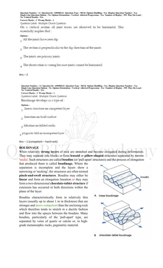
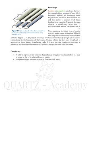
Ans – 2
Ans – 1 (competent – hard rock)
BOUDINAGE
When relatively strong layers of rock are stretched and become elongated during deformation.
They may separate into blocks or form lensoid or pillow-shaped structures separated by narrow
'necks'. Such structures are called boudins (or 'pull-apart' structures) and the process of elongation
that produced them is called boudinage. Where the
separation is incomplete and the layers show a
narrowing or 'necking', the structures are often termed
pinch-and-swell structures. Boudins may either be
linear and form an elongation lineation or they may
form a two-dimensional chocolate-tablet structure if
extension has occurred in both directions within the
plane of the layer.
Boudins characteristically form in relatively thin
layers (usually up to about 1 m in thickness) that are
stronger and more competent than the enclosing rock
which therefore tends to stretch in a ductile fashion
and flow into the spaces between the boudins. Many
boudins, particularly of the 'pull-apart' type, are
separated by veins of quartz or calcite or, in high-
grade metamorphic rocks, pegmatitic material.
Boudinage
Boudins are competent rock layers that have
been stretched into segments (Figure 13.4).
Individual boudins are commonly much
longer in one dimension than the other two
and thus define a lineation. Such linear
boudins form where the X-axis of the strain
ellipsoid is significantly larger than Y.
Chocolate-tablet boudins can form when X
Y.
When occurring in folded layers, boudins
typically appear on the limbs of the fold with
their long axes oriented in the direction of the
fold axis (Figure 13.5). In general, boudinage structures are most easily recognized in sections
perpendicular to the long axes of the boudins. Because of this fact they may be difficult to
recognize as linear features in deformed rocks. It is also true that boudins are restricted to
competent layers and therefore more restricted in occurrence than most other lineations.
Competency:
• A relative expression that compares the mechanical strength or resistance to flow of a layer
or object to that of its adjacent layers or matrix.
• Competent objects are more resistant to flow than their matrix.
Ans – 4
Ans – 3
Ans – 2
• NRSC - National Remote Sensing Centre
•
• Active sensors have its own source of light or illumination. In particular, it actively sends
a pulse and measures the backscatter reflected back to the sensor.
• But passive sensors measure reflected sunlight emitted from the sun. When the sun
shines, passive sensors measure this energy. More on this later.
Ans – 1
Ans – 2 (wrong spelling - Alfred Wegener)
Alfred Wegener, in full Alfred Lothar Wegener, (born November 1, 1880, Berlin, Germany—
died November 1930, Greenland), German meteorologist and geophysicist who formulated the
first complete statement of the continental drift hypothesis.
Harry Hess – Sea floor spreading and plate techtonics
Vine and Mathews – The Vine‐Matthews‐Morley (VMM) hypothesis states that, when ocean
crust forms at a midocean ridge (i.e., a spreading center), the cooling crust becomes magnetized
in the direction of Earth's prevailing magnetic field as it cools below the Curie temperature of
the magnetic minerals.
Dutton – Isostasy .
Clarence Edward Dutton was an American geologist and US Army officer.
Clarence Edward Dutton, (born May 15, 1841, Wallingford, Conn., U.S.—died Jan. 4,
1912, Englewood, N.J.), American geologist and pioneer seismologist who developed and named
the principle of isostasy. According to this principle, the level of the Earth’s crust is determined
by its density; lighter material rises, forming continents, mountains, and plateaus, and heavier
material sinks, forming basins and ocean floors.
Ans – 4 (wrong ans given in answer key ans - lineation)
Ans – 2 (Link is in Description, video is available)
Most workers regard the Main Central Thrust (MCT) as one of the key high strain zones in the
Himalaya because it accommodated at least 90 km of shortening, because that shortening exhumed
and buried hanging wall and footwall rocks, and due to geometric and kinematic connections
between the Main Central Thrust and the structurally overlying South Tibet Detachment.
Geologists currently employ three unrelated definitions of the MCT: metamorphic-rheological,
age of motion-structural, or protolith boundary-structural. These disparate definitions generate
map and cross-section MCT positions that vary by up to 5 km of structural distance.
Ans – 4
Word Definition
isabnormal line connecting points of equal deviation from mean temperature
isacoustic line connecting points of equal acoustic quality
isallobar line connecting points of equal change in barometric pressure
iseidomal line connecting points of equal visibility of a spectacle
isentropic line connecting points of equal entropy
isobar line connecting points of same atmospheric pressure
isobase line connecting points of equal land upheaval
isobath line connecting points of equal underwater depth
isobathytherm line connecting points of equal temperature and depth underground
isobront line connecting points of simultaneous storm development
isochar line connecting points of similar distinguishing characteristics of plant life
isochasm line connecting points of equal frequency of aurorae
isocheim line connecting points of same average winter temperature
isochlor line connecting points of equal chlorine concentration
isochor line connecting points of varying conditions under constant volume
isochrone line connecting points of equal time difference or simultaneous occurrence
isoclinal line connecting points of same magnetic dip
isocryme line connecting points of equal winter temperature
isodose line connecting points that receive equal doses of radiation
isodrosotherm line connecting points of equal dew point
isodynamic line connecting points of equal magnetic intensity
isoflor line connecting points of equal number of plant species
isogam line connecting points of equal acceleration due to gravity
isogen line connecting points of equal birthrates
isogeotherm line connecting points of equal subterranean temperature
isogloss line connecting points of similar regional dialect
isogon line connecting points of same specified angle or same wind direction
isogonal line connecting points of equal magnetic declination
isograd line connecting points of similar conditions during geological metamorphism
isogram line connecting points on a map having some similar feature
isograph line connecting points of same linguistic usage in some respect
isohaline line connecting points of equal salinity
isohalsine line connecting points of equal ocean salinity
isohel line connecting points of equal sunlight
isohyet line connecting points of equal rainfall
isokeraunic line connecting points of equal occurrence of thunderstorms
isolex line connecting points of same vocabulary usage
isoline line connecting points on a map having some similar feature
isomagnetic line connecting points of equal magnetic induction
isometric line connecting points of equal variations of pressure
isomorph line connecting points of same linguistic morphological forms
isonephelic line connecting points of equal cloud cover
isopach line connecting points of equal thickness of geological strata
isophene line connecting points of the same phenotype or seasonal variation
isophote line connecting points of equal light intensity from a given source
isopiestic line connecting points of equal pressure but varying temperature and volume
isopiptesis line connecting points of same arrival date of migratory species
isopleth line connecting points of equal aspect of climate
isopor line connecting points of equal annual change in magnetic field
isopycnic line connecting points of equal density
isorithm line connecting points of equal population density
isoseismal line connecting points of same earthquake intensity
isostere line connecting points of equal specific volume of a substance
isotac line joining points where the ice melts at the same time of year
isotach line connecting points of the same wind speed
isothere line connecting points of equal summer temperature
isotherm line connecting points of equal temperature
isothermobath line connecting points of equal temperature at a given ocean depth
isotherombrose line connecting points of equal ratio of summer rainfall to annual rainfall
isovol line connecting points of equal ratio of fixed to volatile carbon in coal
Join us -
Telegram – https://t.me/joinchat/F0YSxRk74GYHjhjMJVL6Nw
WhatsApp Group 1 – https://chat.whatsapp.com/IP8aQw3hsTvEdWQvvwwzSt
WhatsApp Group 2 - https://chat.whatsapp.com/LQmvgO8WXWX45kRh0cU3me
Instagram – https://www.instagram.com/geologistical/
Facebook – https://www.facebook.com/Quartz-Exclusive-Coaching-Institute-for-earth-Sciences-
507962722965703
Slideshare – https://www.slideshare.net/nikhilsherekar
LinkedIn - https://www.linkedin.com/in/nikhil-sherekar-8b179a9b/

Bhu 19 pet_solved_2

  • 1.
    Ans – 2 Ans– 1 (competent – hard rock) BOUDINAGE When relatively strong layers of rock are stretched and become elongated during deformation. They may separate into blocks or form lensoid or pillow-shaped structures separated by narrow 'necks'. Such structures are called boudins (or 'pull-apart' structures) and the process of elongation that produced them is called boudinage. Where the separation is incomplete and the layers show a narrowing or 'necking', the structures are often termed pinch-and-swell structures. Boudins may either be linear and form an elongation lineation or they may form a two-dimensional chocolate-tablet structure if extension has occurred in both directions within the plane of the layer. Boudins characteristically form in relatively thin layers (usually up to about 1 m in thickness) that are stronger and more competent than the enclosing rock which therefore tends to stretch in a ductile fashion and flow into the spaces between the boudins. Many boudins, particularly of the 'pull-apart' type, are separated by veins of quartz or calcite or, in high- grade metamorphic rocks, pegmatitic material.
  • 2.
    Boudinage Boudins are competentrock layers that have been stretched into segments (Figure 13.4). Individual boudins are commonly much longer in one dimension than the other two and thus define a lineation. Such linear boudins form where the X-axis of the strain ellipsoid is significantly larger than Y. Chocolate-tablet boudins can form when X Y. When occurring in folded layers, boudins typically appear on the limbs of the fold with their long axes oriented in the direction of the fold axis (Figure 13.5). In general, boudinage structures are most easily recognized in sections perpendicular to the long axes of the boudins. Because of this fact they may be difficult to recognize as linear features in deformed rocks. It is also true that boudins are restricted to competent layers and therefore more restricted in occurrence than most other lineations. Competency: • A relative expression that compares the mechanical strength or resistance to flow of a layer or object to that of its adjacent layers or matrix. • Competent objects are more resistant to flow than their matrix.
  • 3.
  • 4.
    Ans – 3 Ans– 2 • NRSC - National Remote Sensing Centre • • Active sensors have its own source of light or illumination. In particular, it actively sends a pulse and measures the backscatter reflected back to the sensor. • But passive sensors measure reflected sunlight emitted from the sun. When the sun shines, passive sensors measure this energy. More on this later.
  • 5.
    Ans – 1 Ans– 2 (wrong spelling - Alfred Wegener) Alfred Wegener, in full Alfred Lothar Wegener, (born November 1, 1880, Berlin, Germany— died November 1930, Greenland), German meteorologist and geophysicist who formulated the first complete statement of the continental drift hypothesis.
  • 6.
    Harry Hess –Sea floor spreading and plate techtonics Vine and Mathews – The Vine‐Matthews‐Morley (VMM) hypothesis states that, when ocean crust forms at a midocean ridge (i.e., a spreading center), the cooling crust becomes magnetized in the direction of Earth's prevailing magnetic field as it cools below the Curie temperature of the magnetic minerals. Dutton – Isostasy . Clarence Edward Dutton was an American geologist and US Army officer. Clarence Edward Dutton, (born May 15, 1841, Wallingford, Conn., U.S.—died Jan. 4, 1912, Englewood, N.J.), American geologist and pioneer seismologist who developed and named the principle of isostasy. According to this principle, the level of the Earth’s crust is determined by its density; lighter material rises, forming continents, mountains, and plateaus, and heavier material sinks, forming basins and ocean floors. Ans – 4 (wrong ans given in answer key ans - lineation) Ans – 2 (Link is in Description, video is available) Most workers regard the Main Central Thrust (MCT) as one of the key high strain zones in the Himalaya because it accommodated at least 90 km of shortening, because that shortening exhumed and buried hanging wall and footwall rocks, and due to geometric and kinematic connections between the Main Central Thrust and the structurally overlying South Tibet Detachment. Geologists currently employ three unrelated definitions of the MCT: metamorphic-rheological, age of motion-structural, or protolith boundary-structural. These disparate definitions generate map and cross-section MCT positions that vary by up to 5 km of structural distance.
  • 7.
    Ans – 4 WordDefinition isabnormal line connecting points of equal deviation from mean temperature isacoustic line connecting points of equal acoustic quality isallobar line connecting points of equal change in barometric pressure iseidomal line connecting points of equal visibility of a spectacle isentropic line connecting points of equal entropy isobar line connecting points of same atmospheric pressure isobase line connecting points of equal land upheaval isobath line connecting points of equal underwater depth isobathytherm line connecting points of equal temperature and depth underground isobront line connecting points of simultaneous storm development isochar line connecting points of similar distinguishing characteristics of plant life isochasm line connecting points of equal frequency of aurorae isocheim line connecting points of same average winter temperature isochlor line connecting points of equal chlorine concentration isochor line connecting points of varying conditions under constant volume isochrone line connecting points of equal time difference or simultaneous occurrence isoclinal line connecting points of same magnetic dip isocryme line connecting points of equal winter temperature isodose line connecting points that receive equal doses of radiation isodrosotherm line connecting points of equal dew point isodynamic line connecting points of equal magnetic intensity
  • 8.
    isoflor line connectingpoints of equal number of plant species isogam line connecting points of equal acceleration due to gravity isogen line connecting points of equal birthrates isogeotherm line connecting points of equal subterranean temperature isogloss line connecting points of similar regional dialect isogon line connecting points of same specified angle or same wind direction isogonal line connecting points of equal magnetic declination isograd line connecting points of similar conditions during geological metamorphism isogram line connecting points on a map having some similar feature isograph line connecting points of same linguistic usage in some respect isohaline line connecting points of equal salinity isohalsine line connecting points of equal ocean salinity isohel line connecting points of equal sunlight isohyet line connecting points of equal rainfall isokeraunic line connecting points of equal occurrence of thunderstorms isolex line connecting points of same vocabulary usage isoline line connecting points on a map having some similar feature isomagnetic line connecting points of equal magnetic induction isometric line connecting points of equal variations of pressure isomorph line connecting points of same linguistic morphological forms isonephelic line connecting points of equal cloud cover isopach line connecting points of equal thickness of geological strata isophene line connecting points of the same phenotype or seasonal variation isophote line connecting points of equal light intensity from a given source isopiestic line connecting points of equal pressure but varying temperature and volume isopiptesis line connecting points of same arrival date of migratory species isopleth line connecting points of equal aspect of climate isopor line connecting points of equal annual change in magnetic field isopycnic line connecting points of equal density isorithm line connecting points of equal population density isoseismal line connecting points of same earthquake intensity
  • 9.
    isostere line connectingpoints of equal specific volume of a substance isotac line joining points where the ice melts at the same time of year isotach line connecting points of the same wind speed isothere line connecting points of equal summer temperature isotherm line connecting points of equal temperature isothermobath line connecting points of equal temperature at a given ocean depth isotherombrose line connecting points of equal ratio of summer rainfall to annual rainfall isovol line connecting points of equal ratio of fixed to volatile carbon in coal Join us - Telegram – https://t.me/joinchat/F0YSxRk74GYHjhjMJVL6Nw WhatsApp Group 1 – https://chat.whatsapp.com/IP8aQw3hsTvEdWQvvwwzSt WhatsApp Group 2 - https://chat.whatsapp.com/LQmvgO8WXWX45kRh0cU3me Instagram – https://www.instagram.com/geologistical/ Facebook – https://www.facebook.com/Quartz-Exclusive-Coaching-Institute-for-earth-Sciences- 507962722965703 Slideshare – https://www.slideshare.net/nikhilsherekar LinkedIn - https://www.linkedin.com/in/nikhil-sherekar-8b179a9b/