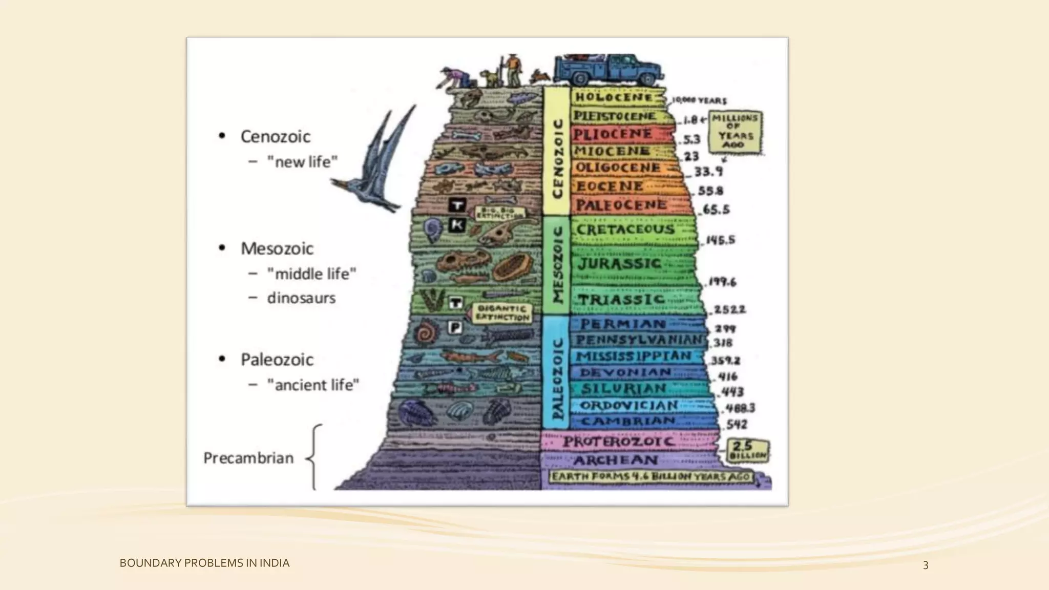
The document discusses boundary problems in geological strata in India, particularly focusing on the transitions between the Precambrian-Cambrian, Permian-Triassic, Cretaceous-Tertiary, and Neogene-Quaternary periods. It highlights the significance of fossil records and stratigraphic evidence in defining these boundaries, detailing specific regional examples across the Indian subcontinent. The work incorporates various geological events and sediment characteristics that inform our understanding of these critical paleontological divisions.
Introduction to boundary problems in geology in India, including Precambrian/Cambrian, Permian/Triassic, Cretaceous/Tertiary, and Neogene/Quaternary boundaries.
Stratigraphic boundaries are defined by geological events like volcanic activity and fossil records.
Exploration of the Precambrian-Cambrian boundary in various locations in India, emphasizing rock types and fossil records, including Cambrian trilobites.
Discussion on the transition between Permian and Triassic periods, detailing fossil records and significant geological sections in India.
Issues related to identifying the Cretaceous-Tertiary boundary, focusing on fossil records and stratigraphic observations in different Indian regions.
The Neogene-Quaternary boundary analysis within continental and marine deposits, highlighting mammal evolution and climatic changes.
Reference text for comprehensive understanding of historical geology and stratigraphy in India.
¢ Stratigraphic boundariesare determined by one or
more of geological events such as volcanic activity,
sedimentation, tectonism, paleo-environments &
evolution of life.
¢ Faunal records have played major role in determining
the boundaries of the Phanerozoic units.
¢ The other geological events are dated on the evidence
of fossil records.
BOUNDARY PROBLEMS IN INDIA 4
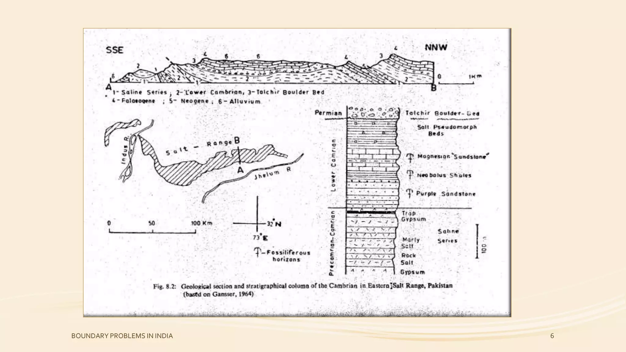
5.
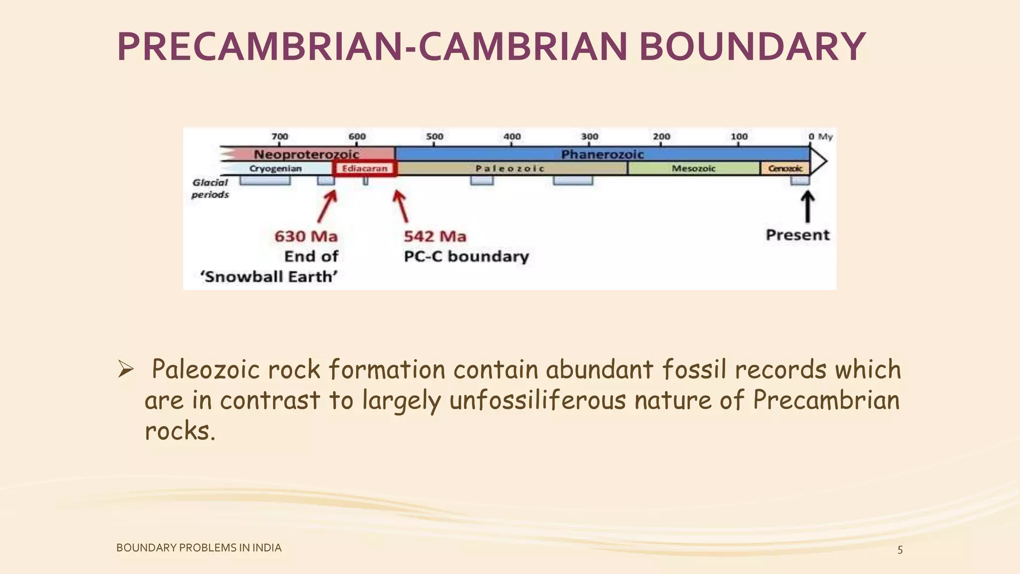
PRECAMBRIAN-CAMBRIAN BOUNDARY
Paleozoicrock formation contain abundant fossil records which
are in contrast to largely unfossiliferous nature of Precambrian
rocks.
BOUNDARY PROBLEMS IN INDIA 5
In saltRange :-
The oldest rocks exposed at the base of the southern cliffs
are known as “SALINE SERIES” Consisting of gypsum, marls &
rock salt.
This succession is conformably overlain by Purple Sandstone,
Neobolus Shales, Magnesian Sandstone & Salt pseudomorph
Beds in that order of succession.
Lower Cambrian trilobits fauna and well preserved trails and
burrows are known from Neobolus shales.
The Magnesian Sandstone, a succession of dolo-arenites,
contains a horizon of shales in the middle of the succession
which has yielded fossils trails & burrows resembling those of
Neobolus Shales.
BOUNDARY PROBLEMS IN INDIA 7
8.
The nature ofcontact between the Lower Cambrian fossiliferous
succession & the underlying “saline Series” of Salt Range is very
often characterized by tectonic disturbance that was explained in
terms of disharmonic folding of competent rocks of Purple
Sandstone resting over highly incompetent salt & gypsum beds of
the “Saline Series” of Precambrian age.
Continuous successions of Precambrian-Cambrian rocks are
exposed in various parts of the tethyan Himalayan zone.
In many sections, however the Lower Cambrian rocks are
unfossiliferous. Even in the fossiliferous section, the fauna is
poorly preserverd for specific & generic identification.
BOUNDARY PROBLEMS IN INDIA 8
9.
In Kashmir:-
A rich assemblage of microbiota cryptarchs & algae of Late
Precambrian (Late Riphean-Vendian) age have been reported
from the Lower part of the Lolab formation.
The upper parts of this formation has yielded trilobites &
brachiopods of upper Lower Cambrian affinity.
The Precambrian-Cambrian boundary is, thus situated
somewhere in the middle of the Lolab formation which has so
far not yielded any fossils record.
In Spiti, the boundary is located in thee middle part of the
Kunzam la Formation.
The fossil record of the Kunzam la formation is similar to that
of the Lolab Formation.
BOUNDARY PROBLEMS IN INDIA 9
10.
In Nandadevi,the fossiliferous Palaeozoic succession rests
over about a 4 km thick unfossiliferous sequesnce of
argillaceous & calcareous fine grained rocks know as Martoli
Formation.
This formation is overlain by about 100m thick Ralam
Conglomerate that constitutes the base of the fossiliferous
Cambrian succession.
The Martoli Formation has been assigned a Late Precambrian
age and the Ralam Conglomerate presumably represents an
unconformity demarcating the Precambrian-Cambrian
boundary.
BOUNDARY PROBLEMS IN INDIA 10
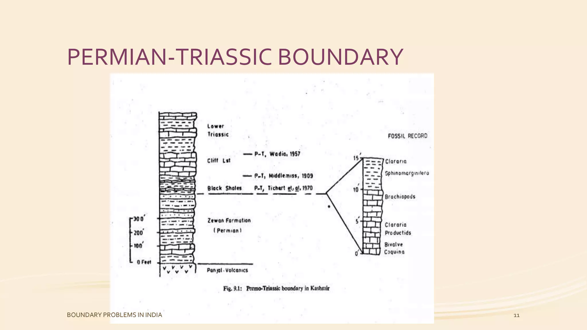
• Fossil faunalof the lowermost Triassic rocks is markedly
different from those of the uppermost Permian.
• Extinction of the brachiopod fauna of the Productus Shales is
as abrupt as the appearance & predominance of Triassic
cephalopods.
• The Guruyul ravine of Vihi district in Kashmir provideds one of
the best known sections where the Permian-Triassic boundary is
defined both on faunal & lithological characteristics.
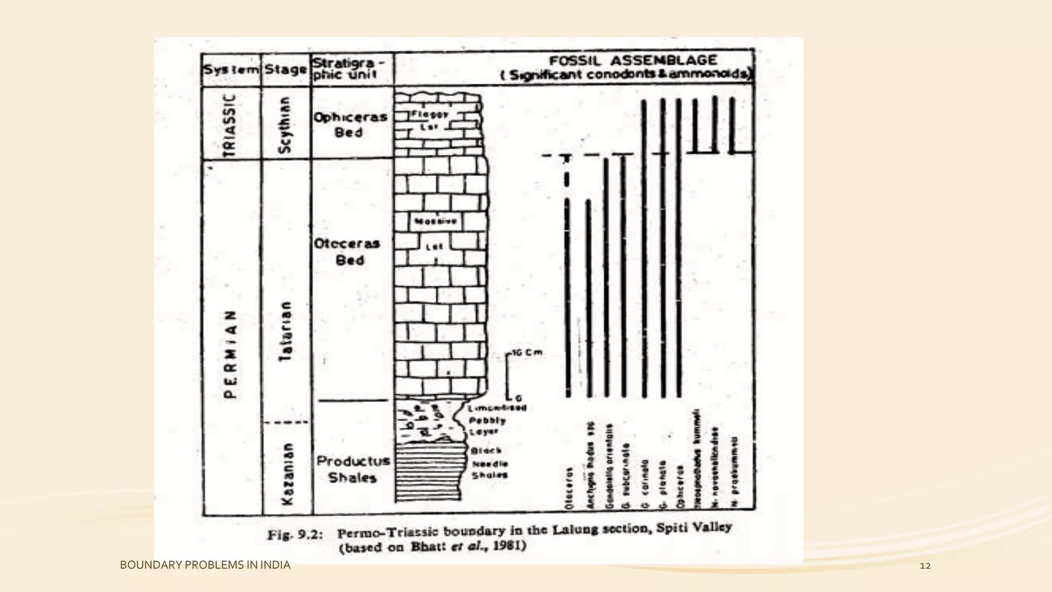
• Palaeontological data from SPITI were regarded to suggest
that the first appearance of Otoceras woodwardi marks the
beginning of the Triassic strata.
• The Triassic succession of Spiti begins with massive limestones
(Otoceras Bed) overlain by flaggy limestone (Ophiceras Bed).
• The carbonate rocks rest over Productus Shale with
intervening thin layes of limonitised pebbly rocks.
BOUNDARY PROBLEMS IN INDIA 13
14.
• Similar observationhave been recorded from Zanskar Range in
the northwest & Kumaun region in the southeast.
• An almost uninterrupted succession of terrestrial sediments of
Permian-Triassic age is recorded in the Gondwana Sequence of
the Indian Peninsula.
• The Permian rocks of the Damuda Group (Lower Gondwana) are
conformably overlain by the Panchat Formation.
• The lower parts of the Panchat Formation consisting of fine
grained inter-channel deposits are genetically closer to the
underlying rocks of the Damuda Group.
• The Upper Panchets are lithologically akin to coarse sediments
of the Mahadeva Formation of the Triassic age.
• The Panchet rocks contain fossil records of particularly two
reptiles, viz., Lystosaurus and Proterosuchus (Chasmatosaurus).
BOUNDARY PROBLEMS IN INDIA 14
15.
The macro-floralrecord of the Gondwana Sequence of India
shows a major change towards the end of the Permian Period
that expressed by the withdrawal of a large number of leaf
genera.
Spores & pollens have been regarded as the most reliable aid
for dating the Permian-Triassic boundary in the Gondwana
Sequence of India. Thus, the Permian-Triassic boundary in the
Gondwana Sequence of India lies somewhere in the middle of
the Panchet Formation.
BOUNDARY PROBLEMS IN INDIA 15
16.
CRETACEOUS-TERTIARY BOUNDARY
• Theproblem of demarcating the boundary line between the
Cretaceous & Tertiary successions has two aspects.
• The one pertains to locating this boundary in a particular region
on the evidence of some fossil record & the other concern with
the “fixing” of this boundary in the internationally accepted
“Standard Stratigraphic Scale”.
• Boundary between the Phanerozoic units are determined on the
faunal evidence with the presumption that the organic forms
have periodically undergone profound changes at certain periods
of the earth history.
• In general, this assumption has been substained by the fossil
records.
BOUNDARY PROBLEMS IN INDIA 16
17.
• In manyparts of the world, stratigraphic breaks have been
observed between the Maastichtian & Montian beds.
• The post-Maastichtian &pre-Montian time interval is
represented in other parts of the world by “passage beds”
which is known as Danian Stage.
• Rocks above the “passage beds” contain fauna that have a
definite Tertiary aspects while the rocks underlying them have
a definite Cretaceous affinity.
• There are three regions in the Indian subcontinent which have
exposed such “passage beds”.
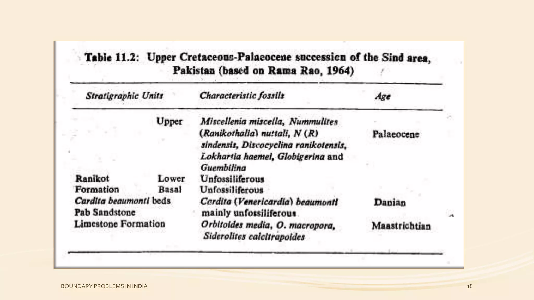
The Sind area in Pakistan.
The Tiruchchirappalli area in south India.
The Assam region in the north-eastern India.
BOUNDARY PROBLEMS IN INDIA 17
The Pab Sandstonewhich in mainly unfossiliferous contain
Maastrichtian fossils in some thin beds at the base & the top of
the sandstone succession.
Since the Cardita beaumonti beds overlie the uppermost
Maastrichtian succession, they have been assigned a Danian age
& the Cardita Beaumonti has been recognized as an index fossil
of the Danian on the Indian subcontinent.
Of the three sub-division of the Ranikot Formation, the basal &
lower sub-division are composed of practically unfossiliferous
sandstone of fluviatile origin.
The upper sub-division of the Ranikot Formation contain
abundant marine Palaeocene fauna which indicates that the
marine regression was short lived.
BOUNDARY PROBLEMS IN INDIA 19
20.
The upper Cretaceousrocks of the Tiruchchirappalli area have
been classified into Uttatur, trichinapoly & Ariyalur formation.
Blanford divided the Ariyalur succession into lower, middle &
upper units.
The upper unit was later recognized as forming a distinct
stratigraphic unit named as Niniyur Formation. Each yielded a
rich assemblage of lamelobranchs, corals & gastropods.
The underlying Ariyalur Foramtion has yielded a foraminiferal
assemblage of Maastrichtian age. The assemblage consists
mainly the species of Lepidoobitoides, Siderolites & Rotalia.
BOUNDARY PROBLEMS IN INDIA 20
21.
• The UpperCretaceous rocks of Assam region comprising the
Mahadek Formation is conformably overlain by a marina
succession known as langpar Formation.
• The Langpar Formation has yielded a Danian foraminiferal
assemblage. The marine rocks are overlain by a thick
continental sequence of coal bearing sandstone known as
Therria Formation.
• Biswas (1962) has suggested that both the Langpar & the
Therria formation were deposited at the same timem the
former being a marine facies equivalent of the continental
Therria Formation.
• Rama Rao grouped both the formation into the “passage beds”
representind the Cretaceous-Tertiary transition.
• Sah & Singh have recorded the presence of a mic-floral break
between the Mahadek & Langpar formations representing the
Cretaceous-Tertiary boundary in Assam.
BOUNDARY PROBLEMS IN INDIA 21
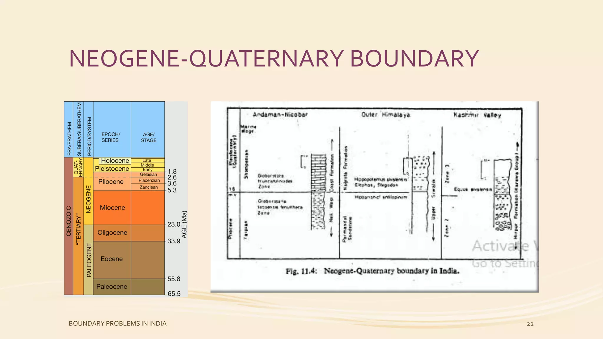
• The Boundaryin India has been investigated in the Continental
deposits of the Outer Himalayas & the Kashmir Valley & the
marine deposits of Andaman-Nicobar islands.
• The basic criteria for the recognition of this boundary in the
continental deposits are the first appearance of certain group
of mammals sach as Elephus, Equus & disappearance of
Hipparion.
• The continental succession contains evidence for the first
climate deterioration leading to the glacial phases at the
commencement of the Quaternary deposits.
• The boundary in the marine succession has been demarcated on
the basis of the appearance & extinction of certain planktonic
foraminifera.
BOUNDARY PROBLEMS IN INDIA 23
24.
REFERENCES
• FUNDAMENTALS OFHISTORICAL GEOLOGY AND
STRATIGRAPHY OF INDIA BY RAVINDRA KUMAR
BOUNDARY PROBLEMS IN INDIA 24