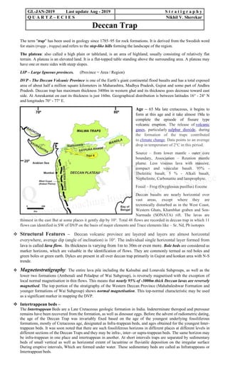
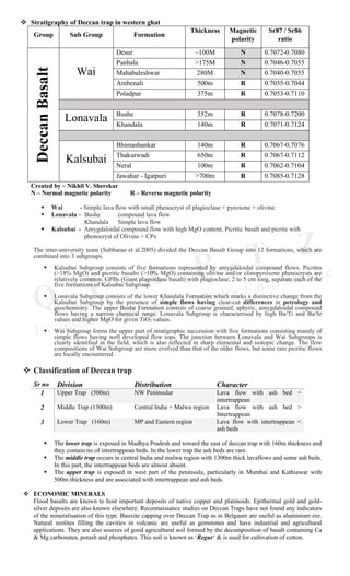
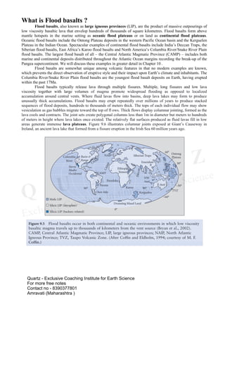
SlideShare a Scribd company logo
1 of 3
Download to read offline
The term "trap" has been used in geology since 1785–95 for rock formations. It is derived from the Swedish word
for stairs (trapp , trappa) and refers to the step-like hills forming the landscape of the region.
The plateau: also called a high plain or tableland, is an area of highland, usually consisting of relatively flat
terrain. A plateau is an elevated land. It is a flat-topped table standing above the surrounding area. A plateau may
have one or more sides with steep slopes.
LIP – Large Igneous provinces. (Province = Area / Region)
DVP - The Deccan Volcanic Province is one of the Earth’s giant continental flood basalts and has a total exposed
area of about half a million square kilometers in Maharashtra, Madhya Pradesh, Gujrat and some part of Andhra
Pradesh. Deccan trap has maximum thickness 3400m in western ghat and its thickness goes decrease toward east
side. At Amrakantat on east its thickness is just 160m. Geographical distribution is between latitudes 16° - 24° N
and longitudes 70° - 77° E.
Age – 65 Ma late cretaceous, it begins to
form at this age and it take almost 1Ma to
complete the episode of fissure type
volcanic eruption. The release of volcanic
gases, particularly sulphur dioxide, during
the formation of the traps contributed
to climate change. Data points to an average
drop in temperature of 2°C in this period.
Source – from lower mantle - outer core
boundary, Association – Reunion mantle
plume. Less viscous lava with massive,
compact and vesicular basalt. 95% -
Tholeiitic basalt, 5 % - Alkali basalt,
Nephelinite, Carbonatite and lamprophyre.
Fossil – Frog (Oxyglossus pusillus) Eocene
Deccan basalts are nearly horizontal over
vast areas, except where they are
tectonically disturbed as in the West Coast,
Western Ghats, Khambhat graben and Son-
Narmada (SONATA) rift. The lavas are
thinnest in the east But at some places it gently dip by 10°. Total 48 flows are recorded in deccan trap in which 11
flows can identified in SW of DVP on the basis of major elements and Trace elements like – Sr, Nd, Pb isotopes
❖ Structural Features – Deccan volcanic province are layered and layers are almost horizontal
everywhere, average dip (angle of inclination) is 10°. The individual single horizontal layer formed from
lava is called lava flow. Its thickness is varying from 1m to 30m or even more. Bole beds are considered as
marker horizons, which are valuable in the identification of flows. They are commonly termed as red boles and
green boles or green earth. Dykes are present in all over deccan trap primarily in Gujrat and konkan area with N-S
trende.
❖ Magnetostratigraphy: The entire lava pile including the Kalsubai and Lonavala Subgroups, as well as the
lower two formations (Ambenali and Poladpur of Wai Subgroup), is reversely magnetised with the exception of
local normal magnetisation in thin flows. This means that nearly 95% of -3000m thick Deccan lavas are reversely
magnetised. The top portion of the stratigraphy of the Western Deccan Province (Mahabaleshwar Formation and
younger formations of Wai Subgroup) shows normal magnetisation. This top-normal characteristic may be used
as a significant marker in mapping the DVP.
❖ Intertrappean beds –
The Intertrappean Beds are a Late Cretaceous geologic formation in India. Indeterminate theropod and pterosaur
remains have been recovered from the formation, as well as dinosaur eggs. Before the advent of radiometric dating,
the age of the Deccan Trap was invariably fixed based on the age of the youngest underlying fossiliferous
formations, mostly of Cretaceous age, designated as Infra-trappean beds, and ages obtained for the youngest Inter-
trappean beds. It was soon noted that there are such fossiliferous horizons in different places at different levels in
different sections of the Deccan Traps and they may be infra-, inter- or supra-trappean beds. The same horizon may
be infra-trappean in one place and intertrappean in another. At short intervals traps are separated by sedimentary
beds of small vertical as well as horizontal extent of lacustrine or fluviatile deposition on the irregular surface
During eruptive intervals, Which are formed under water. These sedimentary beds are called as Infratrappeans or
Intertrappean beds.
GL-JAN-2019 Last update Aug - 2019 S t r a t i g r a p h y
Q U A R T Z – E C I E S Nikhil V. Sherekar
Deccan Trap
❖ Stratigraphy of Deccan trap in western ghat
Group Sub Group Formation
Thickness Magnetic
polarity
Sr87 / Sr86
ratio
DeccanBasalt
Wai
Desur ~100M N 0.7072-0.7080
Panhala >175M N 0.7046-0.7055
Mahabaleshwar 280M N 0.7040-0.7055
Ambenali 500m R 0.7035-0.7044
Poladpur 375m R 0.7053-0.7110
Lonavala Bushe 352m R 0.7078-0.7200
Khandala 140m R 0.7071-0.7124
Kalsubai
Bhimashankar 140m R 0.7067-0.7076
Thakurwadi 650m R 0.7067-0.7112
Neral 100m R 0.7062-0.7104
Jawahar - Igatpuri >700m R 0.7085-0.7128
Created by – Nikhil V. Sherekar
N – Normal magnetic polarity R – Reverse magnetic polarity
▪ Wai - Simple lava flow with small phenocryst of plagioclase + pyroxene + olivine
▪ Lonavala – Bushe compound lava flow
Khandala Simple lava flow
▪ Kalsubai - Amygdaloidal compound flow with high MgO content, Picritic basalt and picrite with
phenocryst of Olivine + CPx
The inter-university team (Subbarao et al.2005) divided the Deccan Basalt Group into 12 formations, which are
combined into 3 subgroups.
▪ Kalsubai Subgroup consists of five formations represented by amygdaloidal compound flows. Picrites
(>18% MgO) and picritic basalts (>10% MgO) containing olivine and/or clinopyroxene phenocrysts are
relatively common. GPBs (Giant plagioclase basalt) with plagioclase, 2 to 5 cm long, separate each of the
five formations of Kalsubai Subgroup.
▪ Lonavala Subgroup consists of the lower Khandala Formation which marks a distinctive change from the
Kalsubai Subgroup by the presence of simple flows having clear-cut differences in petrology and
geochemistry. The upper Bushe Formation consists of coarse grained, aphyric, amygdaloidal compound
flows having a narrow chemical range. Lonavala Subgroup is characterised by high Ba/Ti and Ba/Sr
values and higher MgO for given TiO2 values.
▪ Wai Subgroup forms the upper part of stratigraphic succession with five formations consisting mainly of
simple flows having well developed flow tops. The junction between Lonavala and Wai Subgroups is
clearly identified in the field, which is also reflected in sharp elemental and isotopic change. The flow
compositions of Wai Subgroup are more evolved than that of the older flows, but some rare picritic flows
are locally encountered.
❖ Classification of Deccan trap
Sr no Division Distribution Character
1 Upper Trap (500m) NW Peninsular Lava flow with ash bed +
intertrappean
2 Middle Trap (1300m) Central India + Malwa region Lava flow with ash bed >
Intertrappean
3 Lower Trap (160m) MP and Eastern region Lava flow with intertrappean <
ash beds
▪ The lower trap is exposed in Madhya Pradesh and toward the east of deccan trap with 160m thickness and
they contain no of intertrappean beds. In the lower trap the ash beds are rare.
▪ The middle trap occurs in central India and malwa region with 1300m thick lavaflows and some ash beds.
In this part, the intertrappean beds are almost absent.
▪ The upper trap is exposed in west part of the peninsula, particularly in Mumbai and Kathiawar with
500m thickness and are associated with intertrappean and ash beds.
❖ ECONOMIC MINERALS
Flood basalts are known to host important deposits of native copper and platinoids. Epithermal gold and gold-
silver deposits are also known elsewhere. Reconnaissance studies on Deccan Traps have not found any indicators
of the mineralisation of this type. Bauxite capping over Deccan Trap as in Belgaum are useful as aluminium ore.
Natural zeolites filling the cavities in volcanic are useful as gemstones and have industrial and agricultural
applications. They are also sources of good agricultural soil formed by the decomposition of basalt containing Ca
& Mg carbonates, potash and phosphates. This soil is known as ʻRegurʻ & is used for cultivation of cotton.
What is Flood basalts ?
Flood basalts, also known as large igneous provinces (LIP), are the product of massive outpourings of
low viscosity basaltic lava that envelop hundreds of thousands of square kilometres. Flood basalts form above
mantle hotspots in the marine setting as oceanic flood plateaus or on land as continental flood plateaus.
Oceanic flood basalts include the Ontong Plateau deposits in the western Pacific Ocean basin and the Kerguelen
Plateau in the Indian Ocean. Spectacular examples of continental flood basalts include India’s Deccan Traps, the
Siberian flood basalts, East Africa’s Karoo flood basalts and North America’s Columbia River/Snake River Plain
flood basalts. The largest flood basalt of all – the Central Atlantic Magmatic Province (CAMP) – includes both
marine and continental deposits distributed throughout the Atlantic Ocean margins recording the break-up of the
Pangea supercontinent. We will discuss these examples in greater detail in Chapter 10 .
Flood basalts are somewhat unique among volcanic features in that no modern examples are known,
which prevents the direct observation of eruptive style and their impact upon Earth’s climate and inhabitants. The
Columbia River/Snake River Plain flood basalts are the youngest flood basalt deposits on Earth, having erupted
within the past 17Ma.
Flood basalts typically release lava through multiple fissures. Multiple, long fissures and low lava
viscosity together with large volumes of magma promote widespread flooding as opposed to localized
accumulation around central vents. Where fluid lavas flow into basins, deep lava lakes may form to produce
unusually thick accumulations. Flood basalts may erupt repeatedly over millions of years to produce stacked
sequences of flood deposits, hundreds to thousands of meters thick. The tops of each individual flow may show
vesiculation as gas bubbles migrate toward the top of fl ows. Thick flows display columnar jointing, formed as the
lava cools and contracts. The joint sets create polygonal columns less than 1m in diameter but meters to hundreds
of meters in height where lava lakes once existed. The relatively flat surfaces produced as fluid lavas fill in low
areas generate immense lava plateaus. Figure 9.6 illustrates columnar joints exposed at Giant’s Causeway in
Ireland, an ancient lava lake that formed from a fissure eruption in the Irish Sea 60 million years ago.
Quartz - Exclusive Coaching Institute for Earth Science
For more free notes
Contact no - 8390377801
Amravati (Maharashtra )

More Related Content

What's hot

What's hot (20)

METAMORPHIC DIFFERENTIATION
METAMORPHIC DIFFERENTIATIONMETAMORPHIC DIFFERENTIATION
METAMORPHIC DIFFERENTIATION
 
Deccan traps
Deccan trapsDeccan traps
Deccan traps
 
Dharwar super group
Dharwar super groupDharwar super group
Dharwar super group
 
Heavy minerals
Heavy mineralsHeavy minerals
Heavy minerals
 
Metallogenic Epoch and Province
Metallogenic Epoch and Province Metallogenic Epoch and Province
Metallogenic Epoch and Province
 
Wall Rock Alteration
Wall Rock AlterationWall Rock Alteration
Wall Rock Alteration
 
Economic geology - Metallogeny and plate tectonics
Economic geology - Metallogeny and plate tectonicsEconomic geology - Metallogeny and plate tectonics
Economic geology - Metallogeny and plate tectonics
 
Paleozoic stratigraphy
Paleozoic stratigraphy Paleozoic stratigraphy
Paleozoic stratigraphy
 
Lamprophyre
LamprophyreLamprophyre
Lamprophyre
 
Ore deposits (contact metamorphism)
Ore deposits (contact metamorphism)Ore deposits (contact metamorphism)
Ore deposits (contact metamorphism)
 
Boundary problems
Boundary problemsBoundary problems
Boundary problems
 
Ice age
Ice ageIce age
Ice age
 
Paired metamorphic belts
Paired metamorphic beltsPaired metamorphic belts
Paired metamorphic belts
 
9atharva pawar
9atharva pawar9atharva pawar
9atharva pawar
 
Siwalik supergroup
Siwalik supergroupSiwalik supergroup
Siwalik supergroup
 
Carbonatites
CarbonatitesCarbonatites
Carbonatites
 
Singhbhum Craton
Singhbhum CratonSinghbhum Craton
Singhbhum Craton
 
Cratons of india
Cratons of indiaCratons of india
Cratons of india
 
Chromite.docx
Chromite.docxChromite.docx
Chromite.docx
 
Southern granulite
Southern granuliteSouthern granulite
Southern granulite
 

Similar to Deccan trap

Development of Indian Coast
Development of Indian CoastDevelopment of Indian Coast
Development of Indian CoastAmber Bhaumik
 
Narmada, kutch & saurastra basin
Narmada, kutch & saurastra basinNarmada, kutch & saurastra basin
Narmada, kutch & saurastra basinKaneti Pramod
 
The geological , mineralogical and petrological studies of holenarsipura sch...
The geological , mineralogical  and petrological studies of holenarsipura sch...The geological , mineralogical  and petrological studies of holenarsipura sch...
The geological , mineralogical and petrological studies of holenarsipura sch...Pramoda Raj
 
Plate_Tectonics & Metamorphism.ppt
Plate_Tectonics & Metamorphism.pptPlate_Tectonics & Metamorphism.ppt
Plate_Tectonics & Metamorphism.pptRaviRaj414086
 
Cole, J. M. & Crittenden, S., 1997_sundabasins[1]
Cole, J. M. &  Crittenden, S.,  1997_sundabasins[1]Cole, J. M. &  Crittenden, S.,  1997_sundabasins[1]
Cole, J. M. & Crittenden, S., 1997_sundabasins[1]Stephen Crittenden
 
Mountains, Plateaus and Plains
Mountains, Plateaus and PlainsMountains, Plateaus and Plains
Mountains, Plateaus and Plainsracquel escano
 
Geology 103 field presentation
Geology 103 field presentationGeology 103 field presentation
Geology 103 field presentationgnlopez
 
PALAEOZOIC SUCCESSION OF SPITI.pptx
PALAEOZOIC SUCCESSION OF SPITI.pptxPALAEOZOIC SUCCESSION OF SPITI.pptx
PALAEOZOIC SUCCESSION OF SPITI.pptxRitikDhorta
 
TYPES OF SEDIMENTARY ENVIRONMENTS.ppt
TYPES OF SEDIMENTARY ENVIRONMENTS.pptTYPES OF SEDIMENTARY ENVIRONMENTS.ppt
TYPES OF SEDIMENTARY ENVIRONMENTS.pptSaadTaman
 
Niewejaarskraal resource summary July 2013
Niewejaarskraal resource summary July 2013Niewejaarskraal resource summary July 2013
Niewejaarskraal resource summary July 2013James AH Campbell
 
Sedimentary basins
Sedimentary basinsSedimentary basins
Sedimentary basinsSohail Nawab
 
SALT RANGE FIELD REPORT
SALT RANGE FIELD REPORT SALT RANGE FIELD REPORT
SALT RANGE FIELD REPORT Mansoooraziz84
 
Precambrian cambrian boundary with reference to india
Precambrian cambrian boundary with reference to indiaPrecambrian cambrian boundary with reference to india
Precambrian cambrian boundary with reference to indiaPramoda Raj
 

Similar to Deccan trap (20)

Deccan trap
Deccan trapDeccan trap
Deccan trap
 
Salt range field report
Salt range field reportSalt range field report
Salt range field report
 
Development of Indian Coast
Development of Indian CoastDevelopment of Indian Coast
Development of Indian Coast
 
Narmada, kutch & saurastra basin
Narmada, kutch & saurastra basinNarmada, kutch & saurastra basin
Narmada, kutch & saurastra basin
 
The geological , mineralogical and petrological studies of holenarsipura sch...
The geological , mineralogical  and petrological studies of holenarsipura sch...The geological , mineralogical  and petrological studies of holenarsipura sch...
The geological , mineralogical and petrological studies of holenarsipura sch...
 
Gondwana stratigraphy
Gondwana stratigraphy Gondwana stratigraphy
Gondwana stratigraphy
 
Plate_Tectonics & Metamorphism.ppt
Plate_Tectonics & Metamorphism.pptPlate_Tectonics & Metamorphism.ppt
Plate_Tectonics & Metamorphism.ppt
 
Cole, J. M. & Crittenden, S., 1997_sundabasins[1]
Cole, J. M. &  Crittenden, S.,  1997_sundabasins[1]Cole, J. M. &  Crittenden, S.,  1997_sundabasins[1]
Cole, J. M. & Crittenden, S., 1997_sundabasins[1]
 
palaeozoic
 palaeozoic palaeozoic
palaeozoic
 
Deccan Traps
Deccan Traps Deccan Traps
Deccan Traps
 
Stromatolites
StromatolitesStromatolites
Stromatolites
 
Mountains, Plateaus and Plains
Mountains, Plateaus and PlainsMountains, Plateaus and Plains
Mountains, Plateaus and Plains
 
Geology 103 field presentation
Geology 103 field presentationGeology 103 field presentation
Geology 103 field presentation
 
PALAEOZOIC SUCCESSION OF SPITI.pptx
PALAEOZOIC SUCCESSION OF SPITI.pptxPALAEOZOIC SUCCESSION OF SPITI.pptx
PALAEOZOIC SUCCESSION OF SPITI.pptx
 
Secrets of the deep
Secrets of the deepSecrets of the deep
Secrets of the deep
 
TYPES OF SEDIMENTARY ENVIRONMENTS.ppt
TYPES OF SEDIMENTARY ENVIRONMENTS.pptTYPES OF SEDIMENTARY ENVIRONMENTS.ppt
TYPES OF SEDIMENTARY ENVIRONMENTS.ppt
 
Niewejaarskraal resource summary July 2013
Niewejaarskraal resource summary July 2013Niewejaarskraal resource summary July 2013
Niewejaarskraal resource summary July 2013
 
Sedimentary basins
Sedimentary basinsSedimentary basins
Sedimentary basins
 
SALT RANGE FIELD REPORT
SALT RANGE FIELD REPORT SALT RANGE FIELD REPORT
SALT RANGE FIELD REPORT
 
Precambrian cambrian boundary with reference to india
Precambrian cambrian boundary with reference to indiaPrecambrian cambrian boundary with reference to india
Precambrian cambrian boundary with reference to india
 

More from Nikhil Sherekar

Guidelines for lithological, structural and geomorphic interpretation
Guidelines for lithological, structural and geomorphic interpretationGuidelines for lithological, structural and geomorphic interpretation
Guidelines for lithological, structural and geomorphic interpretationNikhil Sherekar
 
Fundmetal concepts of geomorphology
Fundmetal concepts of geomorphologyFundmetal concepts of geomorphology
Fundmetal concepts of geomorphologyNikhil Sherekar
 
Tools of geomorphologist
Tools of geomorphologistTools of geomorphologist
Tools of geomorphologistNikhil Sherekar
 
Cephalopods (Palaentology Practical B.Sc Geology)
Cephalopods (Palaentology Practical B.Sc Geology)Cephalopods (Palaentology Practical B.Sc Geology)
Cephalopods (Palaentology Practical B.Sc Geology)Nikhil Sherekar
 

More from Nikhil Sherekar (12)

Bhu 19 pet_solved_3
Bhu 19 pet_solved_3Bhu 19 pet_solved_3
Bhu 19 pet_solved_3
 
Bhu 19 pet_solved_2
Bhu 19 pet_solved_2Bhu 19 pet_solved_2
Bhu 19 pet_solved_2
 
Bhu 19 pet_solved_1
Bhu 19 pet_solved_1Bhu 19 pet_solved_1
Bhu 19 pet_solved_1
 
Guidelines for lithological, structural and geomorphic interpretation
Guidelines for lithological, structural and geomorphic interpretationGuidelines for lithological, structural and geomorphic interpretation
Guidelines for lithological, structural and geomorphic interpretation
 
Fundmetal concepts of geomorphology
Fundmetal concepts of geomorphologyFundmetal concepts of geomorphology
Fundmetal concepts of geomorphology
 
Tools of geomorphologist
Tools of geomorphologistTools of geomorphologist
Tools of geomorphologist
 
Mica
MicaMica
Mica
 
Iron
IronIron
Iron
 
Geological Thermometers
Geological ThermometersGeological Thermometers
Geological Thermometers
 
Asbestos
AsbestosAsbestos
Asbestos
 
Cephalopods (Palaentology Practical B.Sc Geology)
Cephalopods (Palaentology Practical B.Sc Geology)Cephalopods (Palaentology Practical B.Sc Geology)
Cephalopods (Palaentology Practical B.Sc Geology)
 
Space and time kindrets
Space and time kindretsSpace and time kindrets
Space and time kindrets
 

Recently uploaded

Hybridoma Technology ( Production , Purification , and Application )
Hybridoma Technology  ( Production , Purification , and Application  ) Hybridoma Technology  ( Production , Purification , and Application  )
Hybridoma Technology ( Production , Purification , and Application ) Sakshi Ghasle
 
Interactive Powerpoint_How to Master effective communication
Interactive Powerpoint_How to Master effective communicationInteractive Powerpoint_How to Master effective communication
Interactive Powerpoint_How to Master effective communicationnomboosow
 
SOCIAL AND HISTORICAL CONTEXT - LFTVD.pptx
SOCIAL AND HISTORICAL CONTEXT - LFTVD.pptxSOCIAL AND HISTORICAL CONTEXT - LFTVD.pptx
SOCIAL AND HISTORICAL CONTEXT - LFTVD.pptxiammrhaywood
 
POINT- BIOCHEMISTRY SEM 2 ENZYMES UNIT 5.pptx
POINT- BIOCHEMISTRY SEM 2 ENZYMES UNIT 5.pptxPOINT- BIOCHEMISTRY SEM 2 ENZYMES UNIT 5.pptx
POINT- BIOCHEMISTRY SEM 2 ENZYMES UNIT 5.pptxSayali Powar
 
Incoming and Outgoing Shipments in 1 STEP Using Odoo 17
Incoming and Outgoing Shipments in 1 STEP Using Odoo 17Incoming and Outgoing Shipments in 1 STEP Using Odoo 17
Incoming and Outgoing Shipments in 1 STEP Using Odoo 17Celine George
 
_Math 4-Q4 Week 5.pptx Steps in Collecting Data
_Math 4-Q4 Week 5.pptx Steps in Collecting Data_Math 4-Q4 Week 5.pptx Steps in Collecting Data
_Math 4-Q4 Week 5.pptx Steps in Collecting DataJhengPantaleon
 
How to Configure Email Server in Odoo 17
How to Configure Email Server in Odoo 17How to Configure Email Server in Odoo 17
How to Configure Email Server in Odoo 17Celine George
 
Organic Name Reactions for the students and aspirants of Chemistry12th.pptx
Organic Name Reactions  for the students and aspirants of Chemistry12th.pptxOrganic Name Reactions  for the students and aspirants of Chemistry12th.pptx
Organic Name Reactions for the students and aspirants of Chemistry12th.pptxVS Mahajan Coaching Centre
 
Software Engineering Methodologies (overview)
Software Engineering Methodologies (overview)Software Engineering Methodologies (overview)
Software Engineering Methodologies (overview)eniolaolutunde
 
Paris 2024 Olympic Geographies - an activity
Paris 2024 Olympic Geographies - an activityParis 2024 Olympic Geographies - an activity
Paris 2024 Olympic Geographies - an activityGeoBlogs
 
How to Make a Pirate ship Primary Education.pptx
How to Make a Pirate ship Primary Education.pptxHow to Make a Pirate ship Primary Education.pptx
How to Make a Pirate ship Primary Education.pptxmanuelaromero2013
 
18-04-UA_REPORT_MEDIALITERAСY_INDEX-DM_23-1-final-eng.pdf
18-04-UA_REPORT_MEDIALITERAСY_INDEX-DM_23-1-final-eng.pdf18-04-UA_REPORT_MEDIALITERAСY_INDEX-DM_23-1-final-eng.pdf
18-04-UA_REPORT_MEDIALITERAСY_INDEX-DM_23-1-final-eng.pdfssuser54595a
 
mini mental status format.docx
mini    mental       status     format.docxmini    mental       status     format.docx
mini mental status format.docxPoojaSen20
 
Introduction to ArtificiaI Intelligence in Higher Education
Introduction to ArtificiaI Intelligence in Higher EducationIntroduction to ArtificiaI Intelligence in Higher Education
Introduction to ArtificiaI Intelligence in Higher Educationpboyjonauth
 
URLs and Routing in the Odoo 17 Website App
URLs and Routing in the Odoo 17 Website AppURLs and Routing in the Odoo 17 Website App
URLs and Routing in the Odoo 17 Website AppCeline George
 
Class 11 Legal Studies Ch-1 Concept of State .pdf
Class 11 Legal Studies Ch-1 Concept of State .pdfClass 11 Legal Studies Ch-1 Concept of State .pdf
Class 11 Legal Studies Ch-1 Concept of State .pdfakmcokerachita
 
Call Girls in Dwarka Mor Delhi Contact Us 9654467111
Call Girls in Dwarka Mor Delhi Contact Us 9654467111Call Girls in Dwarka Mor Delhi Contact Us 9654467111
Call Girls in Dwarka Mor Delhi Contact Us 9654467111Sapana Sha
 
Separation of Lanthanides/ Lanthanides and Actinides
Separation of Lanthanides/ Lanthanides and ActinidesSeparation of Lanthanides/ Lanthanides and Actinides
Separation of Lanthanides/ Lanthanides and ActinidesFatimaKhan178732
 

Recently uploaded (20)

Hybridoma Technology ( Production , Purification , and Application )
Hybridoma Technology  ( Production , Purification , and Application  ) Hybridoma Technology  ( Production , Purification , and Application  )
Hybridoma Technology ( Production , Purification , and Application )
 
Interactive Powerpoint_How to Master effective communication
Interactive Powerpoint_How to Master effective communicationInteractive Powerpoint_How to Master effective communication
Interactive Powerpoint_How to Master effective communication
 
SOCIAL AND HISTORICAL CONTEXT - LFTVD.pptx
SOCIAL AND HISTORICAL CONTEXT - LFTVD.pptxSOCIAL AND HISTORICAL CONTEXT - LFTVD.pptx
SOCIAL AND HISTORICAL CONTEXT - LFTVD.pptx
 
POINT- BIOCHEMISTRY SEM 2 ENZYMES UNIT 5.pptx
POINT- BIOCHEMISTRY SEM 2 ENZYMES UNIT 5.pptxPOINT- BIOCHEMISTRY SEM 2 ENZYMES UNIT 5.pptx
POINT- BIOCHEMISTRY SEM 2 ENZYMES UNIT 5.pptx
 
Incoming and Outgoing Shipments in 1 STEP Using Odoo 17
Incoming and Outgoing Shipments in 1 STEP Using Odoo 17Incoming and Outgoing Shipments in 1 STEP Using Odoo 17
Incoming and Outgoing Shipments in 1 STEP Using Odoo 17
 
TataKelola dan KamSiber Kecerdasan Buatan v022.pdf
TataKelola dan KamSiber Kecerdasan Buatan v022.pdfTataKelola dan KamSiber Kecerdasan Buatan v022.pdf
TataKelola dan KamSiber Kecerdasan Buatan v022.pdf
 
_Math 4-Q4 Week 5.pptx Steps in Collecting Data
_Math 4-Q4 Week 5.pptx Steps in Collecting Data_Math 4-Q4 Week 5.pptx Steps in Collecting Data
_Math 4-Q4 Week 5.pptx Steps in Collecting Data
 
How to Configure Email Server in Odoo 17
How to Configure Email Server in Odoo 17How to Configure Email Server in Odoo 17
How to Configure Email Server in Odoo 17
 
Organic Name Reactions for the students and aspirants of Chemistry12th.pptx
Organic Name Reactions  for the students and aspirants of Chemistry12th.pptxOrganic Name Reactions  for the students and aspirants of Chemistry12th.pptx
Organic Name Reactions for the students and aspirants of Chemistry12th.pptx
 
Software Engineering Methodologies (overview)
Software Engineering Methodologies (overview)Software Engineering Methodologies (overview)
Software Engineering Methodologies (overview)
 
Paris 2024 Olympic Geographies - an activity
Paris 2024 Olympic Geographies - an activityParis 2024 Olympic Geographies - an activity
Paris 2024 Olympic Geographies - an activity
 
How to Make a Pirate ship Primary Education.pptx
How to Make a Pirate ship Primary Education.pptxHow to Make a Pirate ship Primary Education.pptx
How to Make a Pirate ship Primary Education.pptx
 
18-04-UA_REPORT_MEDIALITERAСY_INDEX-DM_23-1-final-eng.pdf
18-04-UA_REPORT_MEDIALITERAСY_INDEX-DM_23-1-final-eng.pdf18-04-UA_REPORT_MEDIALITERAСY_INDEX-DM_23-1-final-eng.pdf
18-04-UA_REPORT_MEDIALITERAСY_INDEX-DM_23-1-final-eng.pdf
 
mini mental status format.docx
mini    mental       status     format.docxmini    mental       status     format.docx
mini mental status format.docx
 
Staff of Color (SOC) Retention Efforts DDSD
Staff of Color (SOC) Retention Efforts DDSDStaff of Color (SOC) Retention Efforts DDSD
Staff of Color (SOC) Retention Efforts DDSD
 
Introduction to ArtificiaI Intelligence in Higher Education
Introduction to ArtificiaI Intelligence in Higher EducationIntroduction to ArtificiaI Intelligence in Higher Education
Introduction to ArtificiaI Intelligence in Higher Education
 
URLs and Routing in the Odoo 17 Website App
URLs and Routing in the Odoo 17 Website AppURLs and Routing in the Odoo 17 Website App
URLs and Routing in the Odoo 17 Website App
 
Class 11 Legal Studies Ch-1 Concept of State .pdf
Class 11 Legal Studies Ch-1 Concept of State .pdfClass 11 Legal Studies Ch-1 Concept of State .pdf
Class 11 Legal Studies Ch-1 Concept of State .pdf
 
Call Girls in Dwarka Mor Delhi Contact Us 9654467111
Call Girls in Dwarka Mor Delhi Contact Us 9654467111Call Girls in Dwarka Mor Delhi Contact Us 9654467111
Call Girls in Dwarka Mor Delhi Contact Us 9654467111
 
Separation of Lanthanides/ Lanthanides and Actinides
Separation of Lanthanides/ Lanthanides and ActinidesSeparation of Lanthanides/ Lanthanides and Actinides
Separation of Lanthanides/ Lanthanides and Actinides
 

Deccan trap

  • 1. The term "trap" has been used in geology since 1785–95 for rock formations. It is derived from the Swedish word for stairs (trapp , trappa) and refers to the step-like hills forming the landscape of the region. The plateau: also called a high plain or tableland, is an area of highland, usually consisting of relatively flat terrain. A plateau is an elevated land. It is a flat-topped table standing above the surrounding area. A plateau may have one or more sides with steep slopes. LIP – Large Igneous provinces. (Province = Area / Region) DVP - The Deccan Volcanic Province is one of the Earth’s giant continental flood basalts and has a total exposed area of about half a million square kilometers in Maharashtra, Madhya Pradesh, Gujrat and some part of Andhra Pradesh. Deccan trap has maximum thickness 3400m in western ghat and its thickness goes decrease toward east side. At Amrakantat on east its thickness is just 160m. Geographical distribution is between latitudes 16° - 24° N and longitudes 70° - 77° E. Age – 65 Ma late cretaceous, it begins to form at this age and it take almost 1Ma to complete the episode of fissure type volcanic eruption. The release of volcanic gases, particularly sulphur dioxide, during the formation of the traps contributed to climate change. Data points to an average drop in temperature of 2°C in this period. Source – from lower mantle - outer core boundary, Association – Reunion mantle plume. Less viscous lava with massive, compact and vesicular basalt. 95% - Tholeiitic basalt, 5 % - Alkali basalt, Nephelinite, Carbonatite and lamprophyre. Fossil – Frog (Oxyglossus pusillus) Eocene Deccan basalts are nearly horizontal over vast areas, except where they are tectonically disturbed as in the West Coast, Western Ghats, Khambhat graben and Son- Narmada (SONATA) rift. The lavas are thinnest in the east But at some places it gently dip by 10°. Total 48 flows are recorded in deccan trap in which 11 flows can identified in SW of DVP on the basis of major elements and Trace elements like – Sr, Nd, Pb isotopes ❖ Structural Features – Deccan volcanic province are layered and layers are almost horizontal everywhere, average dip (angle of inclination) is 10°. The individual single horizontal layer formed from lava is called lava flow. Its thickness is varying from 1m to 30m or even more. Bole beds are considered as marker horizons, which are valuable in the identification of flows. They are commonly termed as red boles and green boles or green earth. Dykes are present in all over deccan trap primarily in Gujrat and konkan area with N-S trende. ❖ Magnetostratigraphy: The entire lava pile including the Kalsubai and Lonavala Subgroups, as well as the lower two formations (Ambenali and Poladpur of Wai Subgroup), is reversely magnetised with the exception of local normal magnetisation in thin flows. This means that nearly 95% of -3000m thick Deccan lavas are reversely magnetised. The top portion of the stratigraphy of the Western Deccan Province (Mahabaleshwar Formation and younger formations of Wai Subgroup) shows normal magnetisation. This top-normal characteristic may be used as a significant marker in mapping the DVP. ❖ Intertrappean beds – The Intertrappean Beds are a Late Cretaceous geologic formation in India. Indeterminate theropod and pterosaur remains have been recovered from the formation, as well as dinosaur eggs. Before the advent of radiometric dating, the age of the Deccan Trap was invariably fixed based on the age of the youngest underlying fossiliferous formations, mostly of Cretaceous age, designated as Infra-trappean beds, and ages obtained for the youngest Inter- trappean beds. It was soon noted that there are such fossiliferous horizons in different places at different levels in different sections of the Deccan Traps and they may be infra-, inter- or supra-trappean beds. The same horizon may be infra-trappean in one place and intertrappean in another. At short intervals traps are separated by sedimentary beds of small vertical as well as horizontal extent of lacustrine or fluviatile deposition on the irregular surface During eruptive intervals, Which are formed under water. These sedimentary beds are called as Infratrappeans or Intertrappean beds. GL-JAN-2019 Last update Aug - 2019 S t r a t i g r a p h y Q U A R T Z – E C I E S Nikhil V. Sherekar Deccan Trap
  • 2. ❖ Stratigraphy of Deccan trap in western ghat Group Sub Group Formation Thickness Magnetic polarity Sr87 / Sr86 ratio DeccanBasalt Wai Desur ~100M N 0.7072-0.7080 Panhala >175M N 0.7046-0.7055 Mahabaleshwar 280M N 0.7040-0.7055 Ambenali 500m R 0.7035-0.7044 Poladpur 375m R 0.7053-0.7110 Lonavala Bushe 352m R 0.7078-0.7200 Khandala 140m R 0.7071-0.7124 Kalsubai Bhimashankar 140m R 0.7067-0.7076 Thakurwadi 650m R 0.7067-0.7112 Neral 100m R 0.7062-0.7104 Jawahar - Igatpuri >700m R 0.7085-0.7128 Created by – Nikhil V. Sherekar N – Normal magnetic polarity R – Reverse magnetic polarity ▪ Wai - Simple lava flow with small phenocryst of plagioclase + pyroxene + olivine ▪ Lonavala – Bushe compound lava flow Khandala Simple lava flow ▪ Kalsubai - Amygdaloidal compound flow with high MgO content, Picritic basalt and picrite with phenocryst of Olivine + CPx The inter-university team (Subbarao et al.2005) divided the Deccan Basalt Group into 12 formations, which are combined into 3 subgroups. ▪ Kalsubai Subgroup consists of five formations represented by amygdaloidal compound flows. Picrites (>18% MgO) and picritic basalts (>10% MgO) containing olivine and/or clinopyroxene phenocrysts are relatively common. GPBs (Giant plagioclase basalt) with plagioclase, 2 to 5 cm long, separate each of the five formations of Kalsubai Subgroup. ▪ Lonavala Subgroup consists of the lower Khandala Formation which marks a distinctive change from the Kalsubai Subgroup by the presence of simple flows having clear-cut differences in petrology and geochemistry. The upper Bushe Formation consists of coarse grained, aphyric, amygdaloidal compound flows having a narrow chemical range. Lonavala Subgroup is characterised by high Ba/Ti and Ba/Sr values and higher MgO for given TiO2 values. ▪ Wai Subgroup forms the upper part of stratigraphic succession with five formations consisting mainly of simple flows having well developed flow tops. The junction between Lonavala and Wai Subgroups is clearly identified in the field, which is also reflected in sharp elemental and isotopic change. The flow compositions of Wai Subgroup are more evolved than that of the older flows, but some rare picritic flows are locally encountered. ❖ Classification of Deccan trap Sr no Division Distribution Character 1 Upper Trap (500m) NW Peninsular Lava flow with ash bed + intertrappean 2 Middle Trap (1300m) Central India + Malwa region Lava flow with ash bed > Intertrappean 3 Lower Trap (160m) MP and Eastern region Lava flow with intertrappean < ash beds ▪ The lower trap is exposed in Madhya Pradesh and toward the east of deccan trap with 160m thickness and they contain no of intertrappean beds. In the lower trap the ash beds are rare. ▪ The middle trap occurs in central India and malwa region with 1300m thick lavaflows and some ash beds. In this part, the intertrappean beds are almost absent. ▪ The upper trap is exposed in west part of the peninsula, particularly in Mumbai and Kathiawar with 500m thickness and are associated with intertrappean and ash beds. ❖ ECONOMIC MINERALS Flood basalts are known to host important deposits of native copper and platinoids. Epithermal gold and gold- silver deposits are also known elsewhere. Reconnaissance studies on Deccan Traps have not found any indicators of the mineralisation of this type. Bauxite capping over Deccan Trap as in Belgaum are useful as aluminium ore. Natural zeolites filling the cavities in volcanic are useful as gemstones and have industrial and agricultural applications. They are also sources of good agricultural soil formed by the decomposition of basalt containing Ca & Mg carbonates, potash and phosphates. This soil is known as ʻRegurʻ & is used for cultivation of cotton.
  • 3. What is Flood basalts ? Flood basalts, also known as large igneous provinces (LIP), are the product of massive outpourings of low viscosity basaltic lava that envelop hundreds of thousands of square kilometres. Flood basalts form above mantle hotspots in the marine setting as oceanic flood plateaus or on land as continental flood plateaus. Oceanic flood basalts include the Ontong Plateau deposits in the western Pacific Ocean basin and the Kerguelen Plateau in the Indian Ocean. Spectacular examples of continental flood basalts include India’s Deccan Traps, the Siberian flood basalts, East Africa’s Karoo flood basalts and North America’s Columbia River/Snake River Plain flood basalts. The largest flood basalt of all – the Central Atlantic Magmatic Province (CAMP) – includes both marine and continental deposits distributed throughout the Atlantic Ocean margins recording the break-up of the Pangea supercontinent. We will discuss these examples in greater detail in Chapter 10 . Flood basalts are somewhat unique among volcanic features in that no modern examples are known, which prevents the direct observation of eruptive style and their impact upon Earth’s climate and inhabitants. The Columbia River/Snake River Plain flood basalts are the youngest flood basalt deposits on Earth, having erupted within the past 17Ma. Flood basalts typically release lava through multiple fissures. Multiple, long fissures and low lava viscosity together with large volumes of magma promote widespread flooding as opposed to localized accumulation around central vents. Where fluid lavas flow into basins, deep lava lakes may form to produce unusually thick accumulations. Flood basalts may erupt repeatedly over millions of years to produce stacked sequences of flood deposits, hundreds to thousands of meters thick. The tops of each individual flow may show vesiculation as gas bubbles migrate toward the top of fl ows. Thick flows display columnar jointing, formed as the lava cools and contracts. The joint sets create polygonal columns less than 1m in diameter but meters to hundreds of meters in height where lava lakes once existed. The relatively flat surfaces produced as fluid lavas fill in low areas generate immense lava plateaus. Figure 9.6 illustrates columnar joints exposed at Giant’s Causeway in Ireland, an ancient lava lake that formed from a fissure eruption in the Irish Sea 60 million years ago. Quartz - Exclusive Coaching Institute for Earth Science For more free notes Contact no - 8390377801 Amravati (Maharashtra )