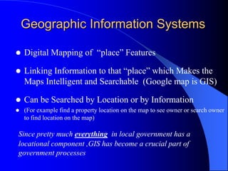
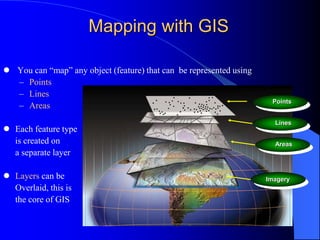
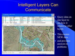
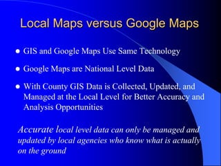
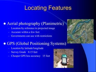
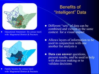
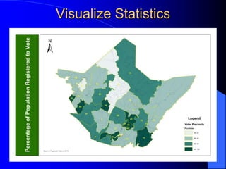
The Power of GIS in GovernmentPast, Present, FutureMelissa ScottGreenbrier County GIS CoordinatorCCAWV Aug. 07, 2011
Geographic Information SystemsWhat is GIS & how exactly does it workGIS in WV (history and available resources)How GIS is being used by County DeptsHow GIS could be used by County Commission Organization of GIS at the County Level
Geographic Information SystemsDigital Mapping of  “place” Features Linking Information to that “place” which Makes the Maps Intelligent and Searchable  (Google map is GIS)Can be Searched by Location or by Information(For example find a property location on the map to see owner or search owner to find location on the map)Since pretty much everything  in local government has a locational component ,GIS has become a crucial part of government processes
Mapping with GIS You can “map” any object (feature) that can  be represented using Points Lines AreasEach feature type	is created on 	a separate layer Layers can be	Overlaid, this is 	the core of GISPointsLinesAreasImagery
LayersLayers are separate files of information that are overlaid to create the “whole picture” while still filing information separatelyIt’s like the old light table conceptRoadsParcelsUtilitiesLand UseZoning and EnvironmentalConsiderations
Biggest Benefit of Map Layers + Databases is “Intelligent Maps”Databases linked to each map layer gives the information intelligence
Intelligent Layers Can CommunicateQuery data on one layer to see how it relates to other layers This creates NEW data…and provides answers to problems
Local Maps versus Google MapsGIS and Google Maps Use Same TechnologyGoogle Maps are National Level DataWith County GIS Data is Collected, Updated, and Managed at the Local Level for Better Accuracy and Analysis Opportunities	Accurate local level data can only be managed and updated by local agencies who know what is actually on the ground
Local GIS MapGoogle MapFocus is Navigation – Prepared for General Pop.Road NamesBusiness LocationsLand Features Focus is Local Gov. – Prepared for Local Pop.ZoningProperty BoundariesBuilding permit Locations
So, how do you get the data “in there”?The data you get out of a GIS system is only as good as the data you put into itImportant to have experienced & informed staff to prevent money/time lossKey word is Digitizing which means getting data from the ground or from paper into the computer
Locating FeaturesAerial photography (Planimetric)Location by reference to projected image Accurate within a few feetGovernments can use with restrictionsGPS (Global Positioning Systems)Location by latitude/longitudeSurvey Grade ±0.15 feet Cheaper GPS less accuracy ±15 feet
Linking Data to Map FeaturesLink tables or databases of information (Usually only available at a local government level)Hyper-link images building plans etc.
BUT…Everything Starts with Foundation (Base Map) Data	When building maps you have to start with an accurate base on which you build other data
West Virginia Base Map Data2003 Statewide Addressing Project (WVSAMB) Created High Quality Base Map Data for every County Address Locations Were Mapped (to national standards) with this Base for Locating 911 Call Locations 	This project (although not perfect) provided the counties an invaluable resource for GIS
WVSAMB GIS Data As a part of assigning address other feature layers created were:ImageryRoads – line layerRailroads  - line layerStructures – points & polygonsWater features – streams, rivers, lakes, ponds, etc.
	Most WV data has been built or aligned with this data including parcels, and even Census Info
Available Imagery-2003 WVSAMB Orthophotographyleaf off-2009 NAIP USDA Orthophotography leaf on-Pictometry – WV Sheriff’s Association4” and/or 12”  Includes Oblique
Some Local Governments Have Paid for their Own New Imagery
Other Data SourcesMany Government Agencies create data layers that are available to countiesThe WV GIS Technical Center has links to pretty much any data topic you can think of  http://wvgis.wvu.edu/
But Why?Mapping YES!But what else could we do with this data?Increase EfficiencyAnalysis of information to help with your decision making and to validate policies change, spending, etc.Spatial InformationIt is estimated that 80% of all data has a spatial componentGIS helps you utilize the spatial component of data when making decisions Information is PowerGIS is also about finding patterns.
Lets you combine/consider data coming from different sources to make better decisions.
Answer the questions of location such as where, why, and how.
See patterns and trends that spreadsheets alone won’t portray.
Access data much more easilyPROJECT SITE FOR PROPOSED WIND ENERGY PROJECTAREA UNDER CONSIDERATION FOR EXTENTION OF EXISTING  WATERLINESGIS INFORMATION CAN HELP ELECTED OFFICIALS MAKE MORE INFORMED DECISIONS BY COMBINING VARIOUS LOCAL DATASETS TO SHOW THE FULL PICTURE OF A PROJECT AREA
GIS CAN BE USED TO LOCATE PROPERTIES AND IDENTIFY OWNERS WITHIN A PARTICULAR DISTANCE OF ANOTHER MAP FEATURE SUCH AS PROPERTIES WITHIN 50’ OF THE FLOODPLAINANALYSIS MAPS HELP BOARDS & ORGANIZATIONS FIND INFORMATION AND SEE TRENDS SUCH AS LOCATION OF POTENTIALLY HISTORICIC STRUCTURESTHIS TECHNOLOGY CAN BE USED TO CREATE 3-D IMAGES OF LANDSCAPES
PARCEL INFORMATIONxREAL ESTATE APPRAISAL/ASSESSMENTZONINGADDRESSING & 911
Benefits of “Intelligent” DataDifferent “sets” of data can be combined and viewed in the same context  for a visual impact
Allows layers of information to be used in conjunction with one another for analysis a
Data can answer questions, present results, and be used to help with decision making or to validate decisionsEducational Attainment  (by census tract) 	with  Magisterial District & Precincts Family Income (by census tract) 	with  Magisterial District & Precincts
Visualize Statistics
Understand Issues
Answer QuestionsDarker = Increase Crime Income Is Low Income or Population a Bigger Crime Determinant?Population
GIS Funding & OrganizationCounty GIS Depts. are typically housed in 911 offices and Assessor’s Offices because of mapping mandates and funding streamsNeed shared funding/management (CC) in order for all departments to take full advantage of GIS
Some Organizational SolutionsDue to the change of focus an election can bring, a multi-departmental management solution is the safest bet.  $$$One solution is to have a GIS Coordinator whose salary is split between the users – Assessor, 911,  OES, Planning Dept, Clerk, County Commission A formal GIS board and GIS department with a separate budge is a higher level solution when cities and other entities want to be included (and contribute to the financial upkeep)
GIS is a Money SaverGIS can Provide Easier Access to Information Through the InternetAnalysis of County Trends Can Assist with Better Policies and More Sound Financial Decisions and Access to Grants etc.

Ccawv 2011 a

  • 1.
    The Power ofGIS in GovernmentPast, Present, FutureMelissa ScottGreenbrier County GIS CoordinatorCCAWV Aug. 07, 2011
  • 2.
    Geographic Information SystemsWhatis GIS & how exactly does it workGIS in WV (history and available resources)How GIS is being used by County DeptsHow GIS could be used by County Commission Organization of GIS at the County Level
  • 3.
    Geographic Information SystemsDigitalMapping of “place” Features Linking Information to that “place” which Makes the Maps Intelligent and Searchable (Google map is GIS)Can be Searched by Location or by Information(For example find a property location on the map to see owner or search owner to find location on the map)Since pretty much everything in local government has a locational component ,GIS has become a crucial part of government processes
  • 4.
    Mapping with GISYou can “map” any object (feature) that can be represented using Points Lines AreasEach feature type is created on a separate layer Layers can be Overlaid, this is the core of GISPointsLinesAreasImagery
  • 5.
    LayersLayers are separatefiles of information that are overlaid to create the “whole picture” while still filing information separatelyIt’s like the old light table conceptRoadsParcelsUtilitiesLand UseZoning and EnvironmentalConsiderations
  • 6.
    Biggest Benefit ofMap Layers + Databases is “Intelligent Maps”Databases linked to each map layer gives the information intelligence
  • 7.
    Intelligent Layers CanCommunicateQuery data on one layer to see how it relates to other layers This creates NEW data…and provides answers to problems
  • 8.
    Local Maps versusGoogle MapsGIS and Google Maps Use Same TechnologyGoogle Maps are National Level DataWith County GIS Data is Collected, Updated, and Managed at the Local Level for Better Accuracy and Analysis Opportunities Accurate local level data can only be managed and updated by local agencies who know what is actually on the ground
  • 9.
    Local GIS MapGoogleMapFocus is Navigation – Prepared for General Pop.Road NamesBusiness LocationsLand Features Focus is Local Gov. – Prepared for Local Pop.ZoningProperty BoundariesBuilding permit Locations
  • 10.
    So, how doyou get the data “in there”?The data you get out of a GIS system is only as good as the data you put into itImportant to have experienced & informed staff to prevent money/time lossKey word is Digitizing which means getting data from the ground or from paper into the computer
  • 11.
    Locating FeaturesAerial photography(Planimetric)Location by reference to projected image Accurate within a few feetGovernments can use with restrictionsGPS (Global Positioning Systems)Location by latitude/longitudeSurvey Grade ±0.15 feet Cheaper GPS less accuracy ±15 feet
  • 12.
    Linking Data toMap FeaturesLink tables or databases of information (Usually only available at a local government level)Hyper-link images building plans etc.
  • 13.
    BUT…Everything Starts withFoundation (Base Map) Data When building maps you have to start with an accurate base on which you build other data
  • 14.
    West Virginia BaseMap Data2003 Statewide Addressing Project (WVSAMB) Created High Quality Base Map Data for every County Address Locations Were Mapped (to national standards) with this Base for Locating 911 Call Locations This project (although not perfect) provided the counties an invaluable resource for GIS
  • 15.
    WVSAMB GIS DataAs a part of assigning address other feature layers created were:ImageryRoads – line layerRailroads - line layerStructures – points & polygonsWater features – streams, rivers, lakes, ponds, etc.
  • 16.
    Most WV datahas been built or aligned with this data including parcels, and even Census Info
  • 17.
    Available Imagery-2003 WVSAMBOrthophotographyleaf off-2009 NAIP USDA Orthophotography leaf on-Pictometry – WV Sheriff’s Association4” and/or 12” Includes Oblique
  • 18.
    Some Local GovernmentsHave Paid for their Own New Imagery
  • 19.
    Other Data SourcesManyGovernment Agencies create data layers that are available to countiesThe WV GIS Technical Center has links to pretty much any data topic you can think of http://wvgis.wvu.edu/
  • 20.
    But Why?Mapping YES!Butwhat else could we do with this data?Increase EfficiencyAnalysis of information to help with your decision making and to validate policies change, spending, etc.Spatial InformationIt is estimated that 80% of all data has a spatial componentGIS helps you utilize the spatial component of data when making decisions Information is PowerGIS is also about finding patterns.
  • 21.
    Lets you combine/considerdata coming from different sources to make better decisions.
  • 22.
    Answer the questionsof location such as where, why, and how.
  • 23.
    See patterns andtrends that spreadsheets alone won’t portray.
  • 24.
    Access data muchmore easilyPROJECT SITE FOR PROPOSED WIND ENERGY PROJECTAREA UNDER CONSIDERATION FOR EXTENTION OF EXISTING WATERLINESGIS INFORMATION CAN HELP ELECTED OFFICIALS MAKE MORE INFORMED DECISIONS BY COMBINING VARIOUS LOCAL DATASETS TO SHOW THE FULL PICTURE OF A PROJECT AREA
  • 25.
    GIS CAN BEUSED TO LOCATE PROPERTIES AND IDENTIFY OWNERS WITHIN A PARTICULAR DISTANCE OF ANOTHER MAP FEATURE SUCH AS PROPERTIES WITHIN 50’ OF THE FLOODPLAINANALYSIS MAPS HELP BOARDS & ORGANIZATIONS FIND INFORMATION AND SEE TRENDS SUCH AS LOCATION OF POTENTIALLY HISTORICIC STRUCTURESTHIS TECHNOLOGY CAN BE USED TO CREATE 3-D IMAGES OF LANDSCAPES
  • 26.
    PARCEL INFORMATIONxREAL ESTATEAPPRAISAL/ASSESSMENTZONINGADDRESSING & 911
  • 27.
    Benefits of “Intelligent”DataDifferent “sets” of data can be combined and viewed in the same context for a visual impact
  • 28.
    Allows layers ofinformation to be used in conjunction with one another for analysis a
  • 29.
    Data can answerquestions, present results, and be used to help with decision making or to validate decisionsEducational Attainment (by census tract) with Magisterial District & Precincts Family Income (by census tract) with Magisterial District & Precincts
  • 30.
  • 31.
  • 32.
    Answer QuestionsDarker =Increase Crime Income Is Low Income or Population a Bigger Crime Determinant?Population
  • 33.
    GIS Funding &OrganizationCounty GIS Depts. are typically housed in 911 offices and Assessor’s Offices because of mapping mandates and funding streamsNeed shared funding/management (CC) in order for all departments to take full advantage of GIS
  • 34.
    Some Organizational SolutionsDueto the change of focus an election can bring, a multi-departmental management solution is the safest bet. $$$One solution is to have a GIS Coordinator whose salary is split between the users – Assessor, 911, OES, Planning Dept, Clerk, County Commission A formal GIS board and GIS department with a separate budge is a higher level solution when cities and other entities want to be included (and contribute to the financial upkeep)
  • 35.
    GIS is aMoney SaverGIS can Provide Easier Access to Information Through the InternetAnalysis of County Trends Can Assist with Better Policies and More Sound Financial Decisions and Access to Grants etc.

Editor's Notes

  • #2 I will talk about what GIS is, how it is used in government, and give you some examples of how it is currently being used and how you can get your county involved in the more advanced uses of GIS
  • #6 Looking at one piece of information on top of another opens up new possibilities in data analysis
  • #7 You can get different types of information on the same area by simply looking a different layer.
  • #8 Comparisons can be done between different pieces of data – which create NEW data. For instance search what structures from the building layer are within the floodplain area? The GIS automatically pulls our that information…then you ask (from the parcel layer) what are the mailing addresses to those properties? Whala – you now have a mailing list of everyone in the floodplain – a new piece of information in a non-map format. Something that can be used for Admin. Purposes.
  • #10 Google is a business and does not focus on local level data – the cost/time is not worth the benefit. The local data is what government officials need to use for decision making and is edited (updated) on a daily basis at the local level and can be manipulated in many ways for analysis. The day may come when the local data can be overlayedfor viewing directly onto google without a lot of complication, but someone at the local level still has to collect, prepare, and manage that data.
  • #11 If you want information that you can rely on, you need to invest in the resources to get it done right at the local level. Bad data management can waste THOUSANDS OF DOLLARS. Getting the data into a GIS in an organized and efficient manner that is consistent with surrounding areas is important . I have seen some projects that took hundred of man hours that end up being worthless data due to lack of research and experience.
  • #13 In GIS when you create a map feature a database is automatically created to store data about the feature – like road name. If you have a common field such as the road name you can then link external tables created by others for instance I could link the DOT data to my road file to show things such as construction plans etc. then create a map highlighting all of the construction areas. This example shows property boundaries - we typed the parcel number into the map then linked the assessment data for the properties using the common piece of information – the parcel number. You can also link other things other than data tables – such as web addresses, pictures, or, documents.
  • #16 The data included roads, railroads, building points and polys for larger structures, water features which includes bank lines instead of just a line through the middle of the water representing the stream way – this is very helpful especially when mapping parcels – in Gbr individuals own islands in the river.
  • #17 Tony may be able to tell you a little bit more about new efforts in statewide mapping
  • #18 There are several dataset of imagery available for free to governments. WVSAMB, NAIP, and now Pictometry. Data sharing of the Pictometry images will be at the discretion of each County Sheriff
  • #19 Here is an example of imagery of Clarksburg imagery 6” each 1 pixel. Mike Fazzino from Harrison County Shared this with me. Local Governments can sometimes recoup the cost of imagery by selling to developers (for site planning) and other agencies and private companies.
  • #20 There is an amazing amount of GIS data available for WV. Data layers can be downloaded for free showing everything from mine permit areas & superfund sites, to trout concentrations and tree types in forests.
  • #22 With the vast sources of information available today, GIS is a key tool in finding out what it all means. With so much information tied to a location, GIS helps find patterns we might not see without a map. GIS can make thematic maps, maps based on different factors, to help illustrate patterns. To explore highway accidents we might make a map coding accidents by whether they occurred at night or during the day, in rain or snow or sunshine. Then, we might see a pattern.Query and AnalysisOnce you have a functioning GIS containing your geographic information, you can begin to ask simple questions such asWho owns the land parcel on the corner?How far is it between two places?Where is land zoned for industrial use? And analytical questions such as Where are all the sites suitable for building new houses?What is the dominant soil type for oak forest?If I build a new highway here, how will traffic be affected?
  • #24 A Gbr Co example is the windmills as a CC you could see for yourself what is in the area, thus what/who will be impacted
  • #25 You could get information to see what issues should be important!
  • #26 If a citizen comes to you with an issues about a property you should know all of the issues that are related so that you can make an informed decision and - look like you are interested and know what you are doing
  • #27 Visual data is comprehended much more quickly and easily – data can be used to validate spending patterns etc.
  • #28 With GIS you can can get information in a format that is easy to understand and interpret.
  • #29 This is much more effective than looking at 220 different spreadsheets – Which is basically how I got this information from Vivian.
  • #30 You can answer questions based on your own analysis of a situation or see when/where you need to gather more information.
  • #31 The State Tax Dept places certain mandates on Assessors concerning the mapping of property boundaries. Mapping in GIS provides SOOO many benefits to Assessors that most are moving in the direction of GIS. The 911 Addressing project provided base GIS maps for all of the Counties so every County has SOME data to start with. It is quickly getting old/dated so the sooner it is used and updated, the better. MANY Depts use GIS County Clerks for voter location and elections data
  • #32 GIS is a large time, resource and, financial investment that all level of government consider worth while. That investment has to be protected for greater good.
  • #33 Knowing where development is happening through tracking building permits,can assist with FEMA regs., planning decisions, and funding opportunities
  • #34 Financially – The State wants cooperation (data sharing) from Counties but there is very little state level funding that filters down to the counties to create and maintain local level data. There needs to be a move toward a consistent funding streaMany grants encourage a GIS component SO money for software and GIS time can be incorporated into many different types of grants.
  • #35 A geographic information system (GIS), geographical information system, or geospatial information system is a system designed to capture, store, manipulate, analyze, manage, and present all types of geographically referenced data.[1] In the simplest terms, GIS is the merging of cartography, statistical analysis, and database technology. - ESRI (ezrie) is like the Microsoft of GIS