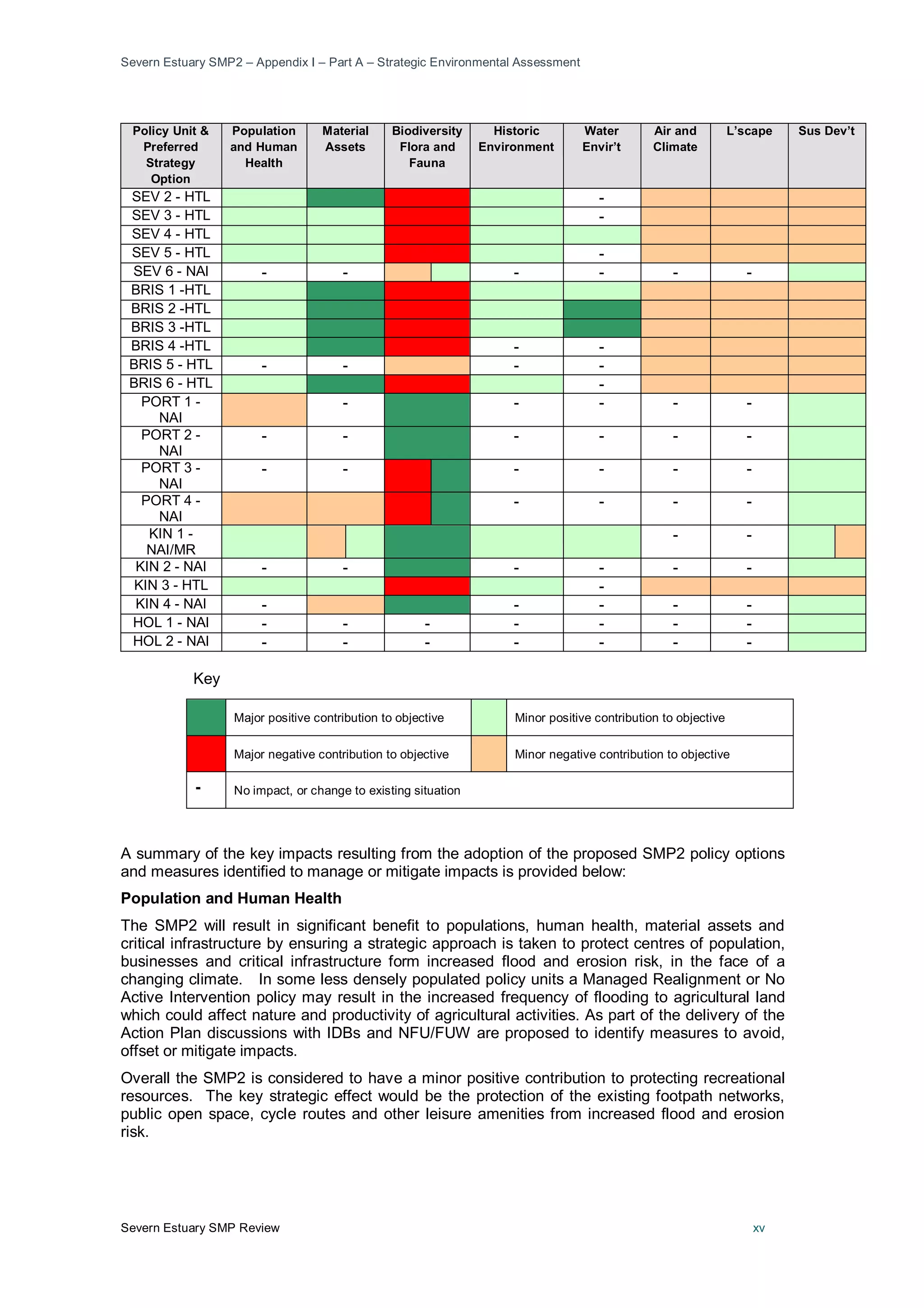
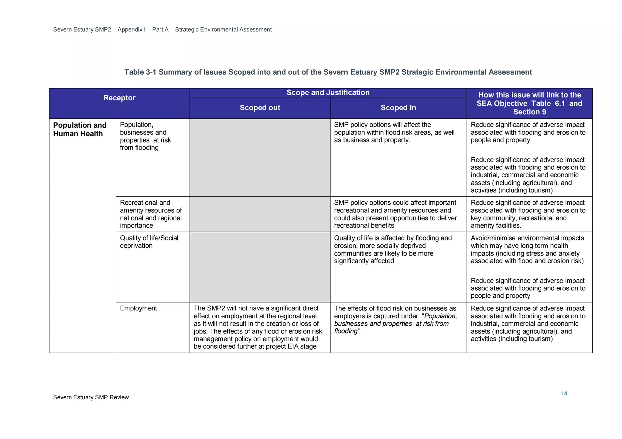
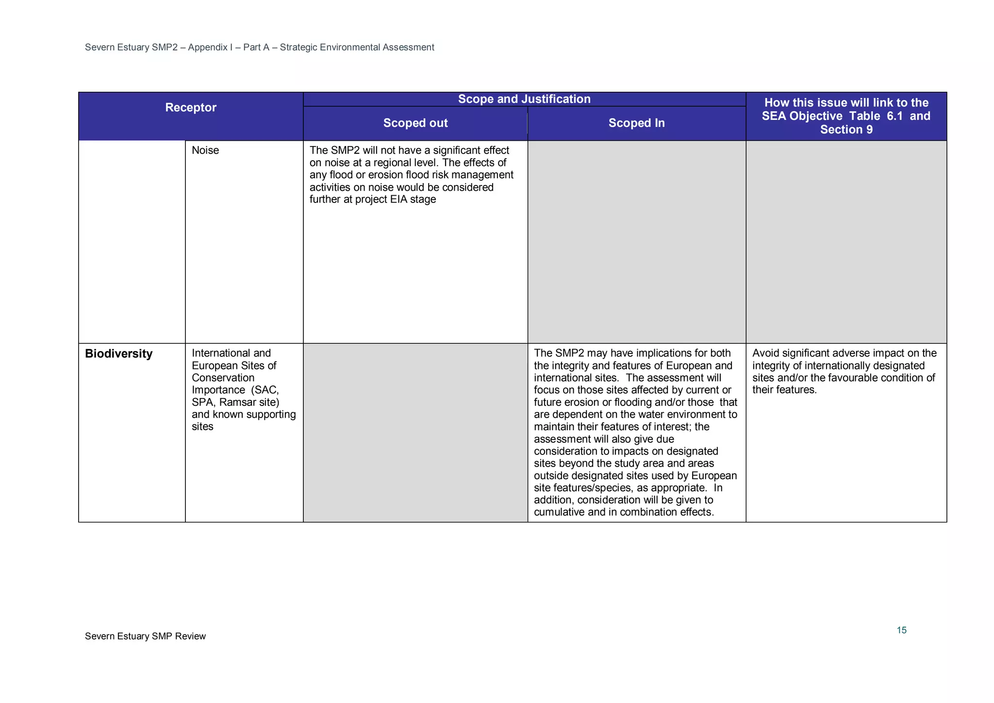
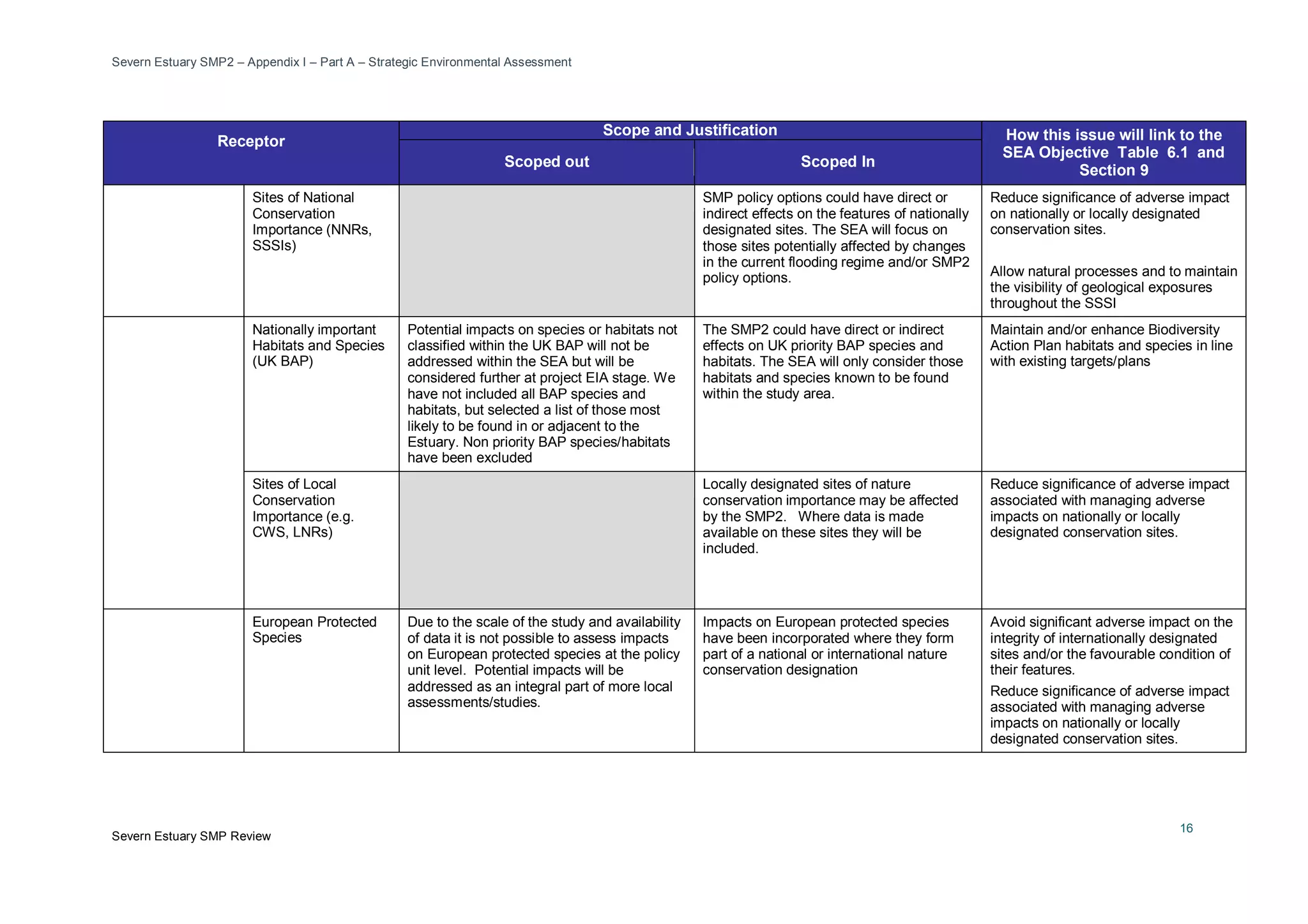
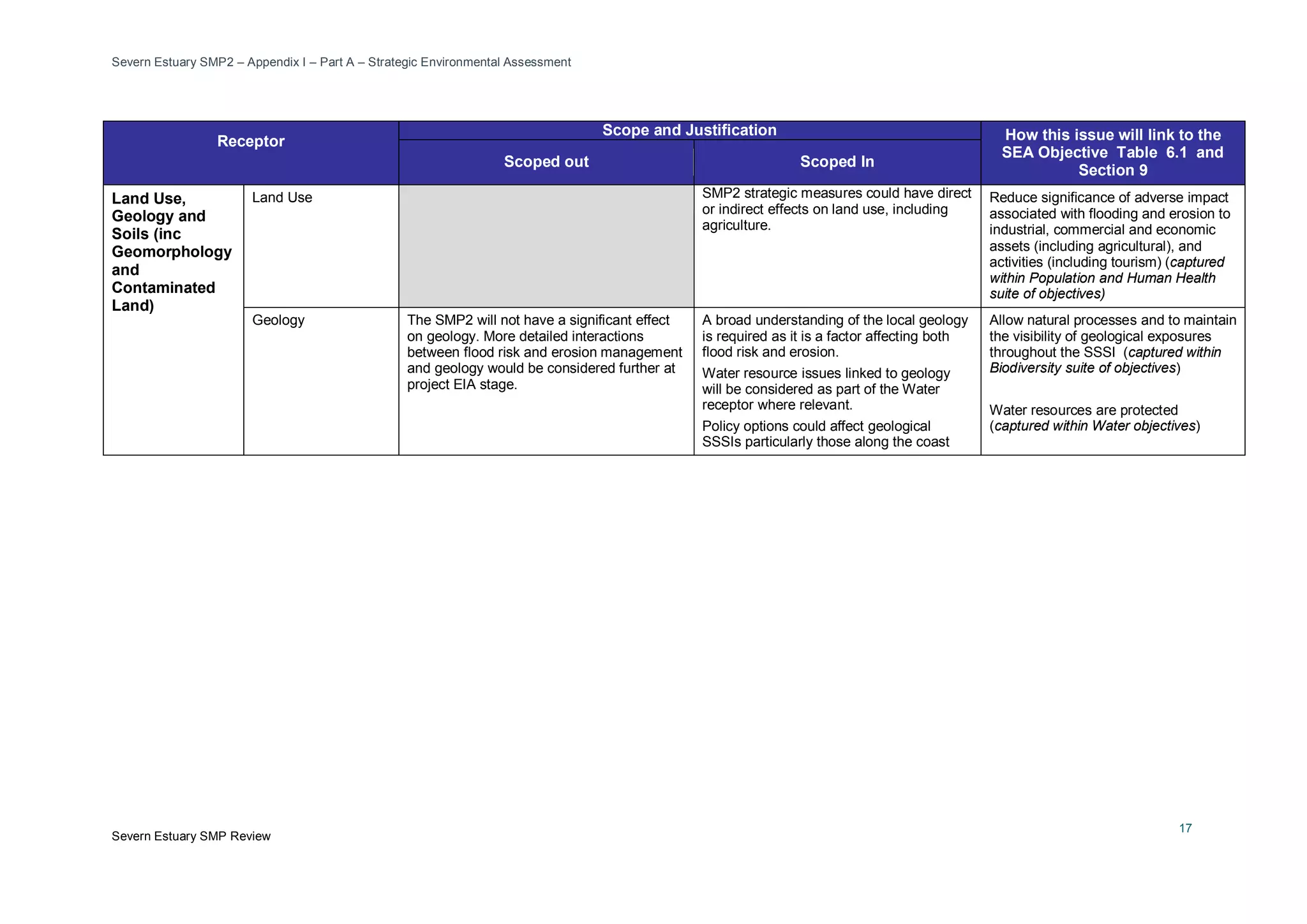
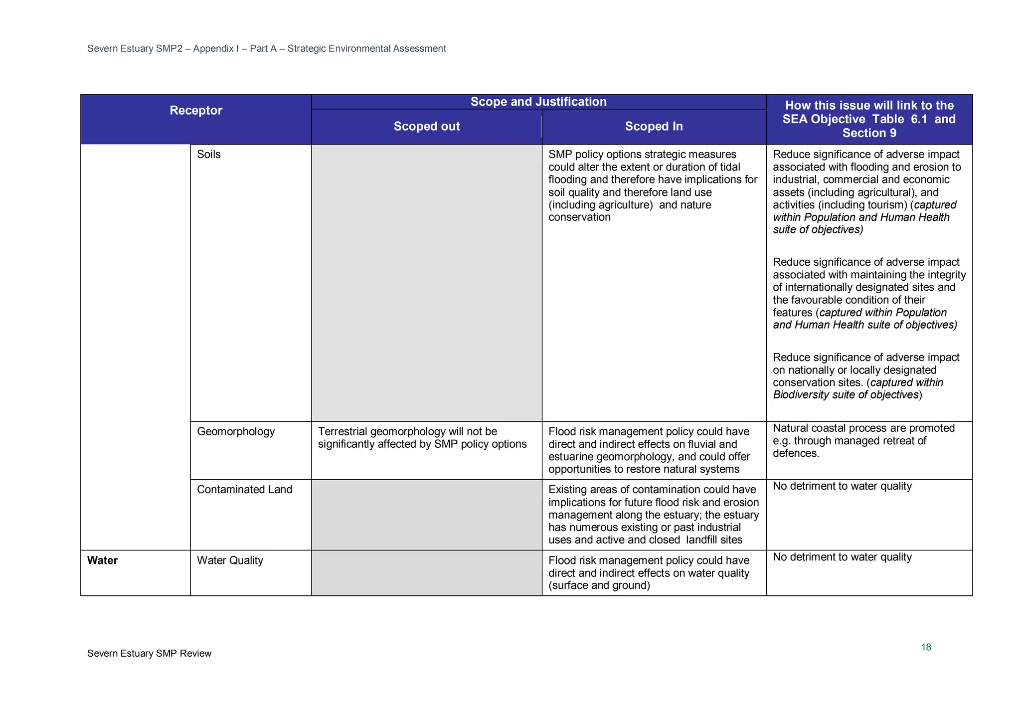
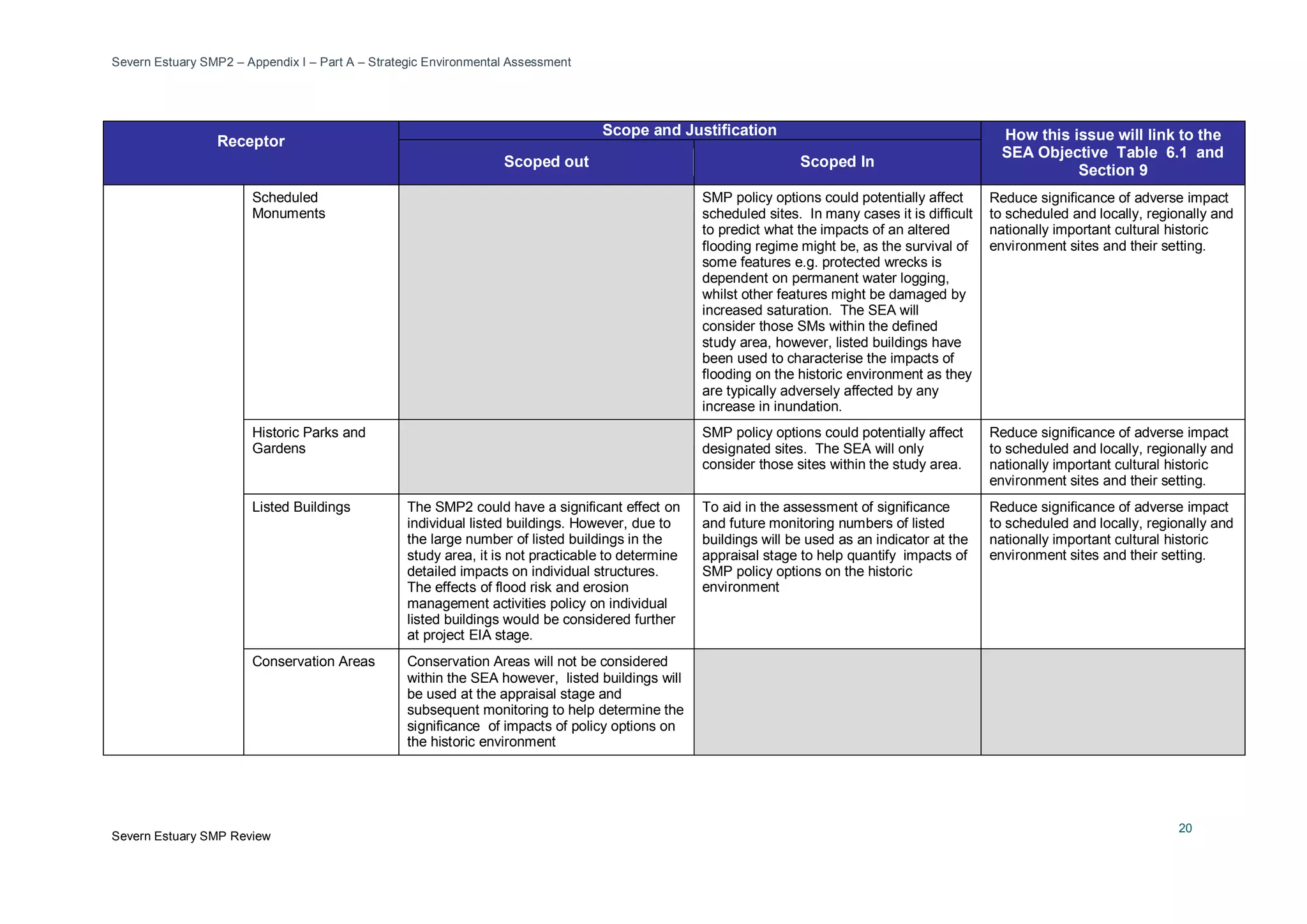
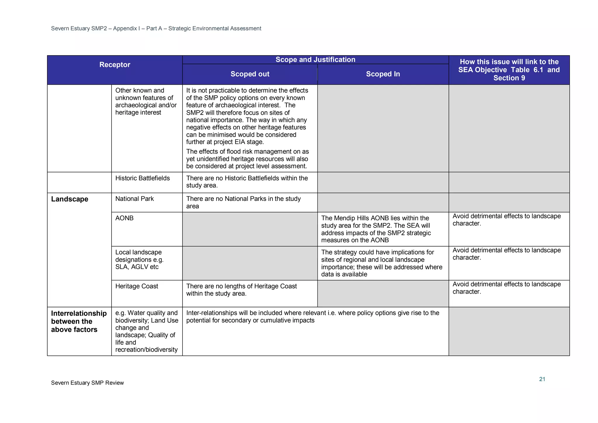
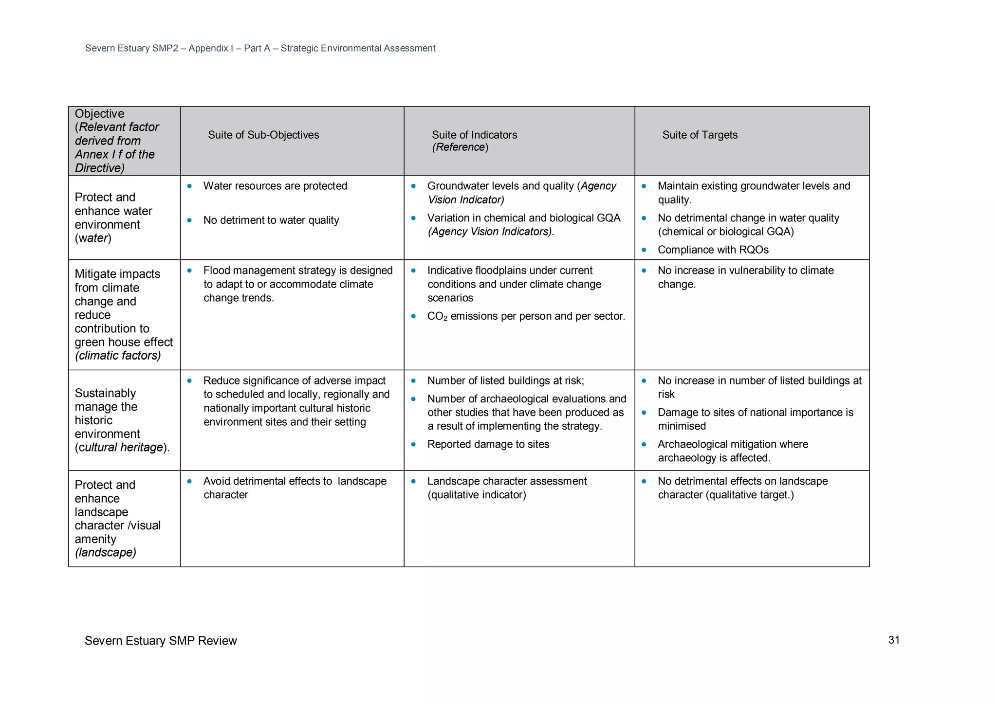
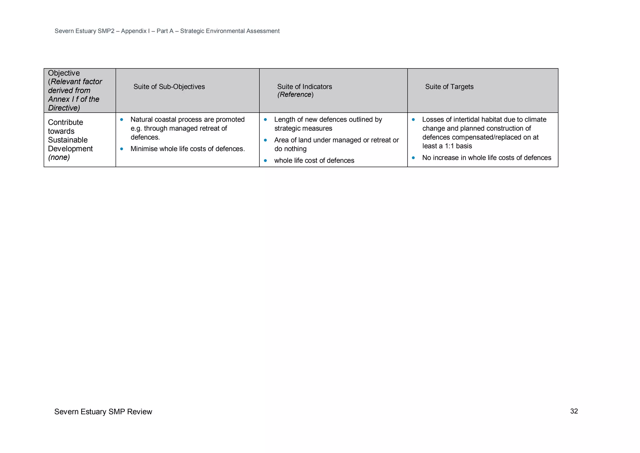
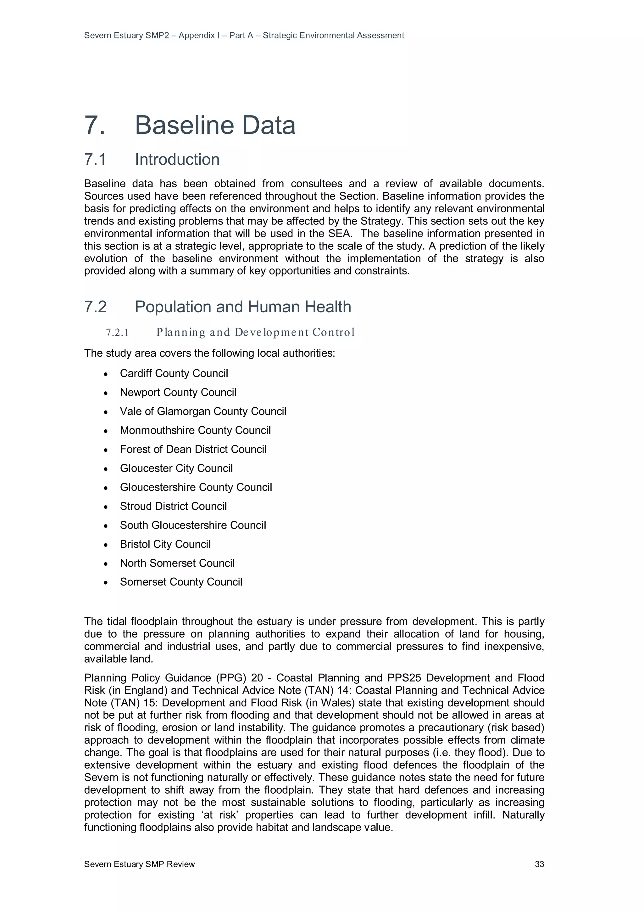
The document provides an environmental assessment report for the Severn Estuary Shoreline Management Plan Review (SMP2). It summarizes the baseline environmental conditions in the study area, including populations and human health, biodiversity, fisheries, geology, land use, water, air and climate, cultural heritage, landscape and contaminated land. It then describes the strategic environmental assessment process undertaken to evaluate the potential environmental impacts of different shoreline management policies. This included developing objectives, consulting stakeholders, reviewing other relevant plans and strategies, and assessing alternative policy options. The preferred policies were selected and their impacts evaluated, including cumulative effects and mitigation measures. An implementation and monitoring plan was also developed to track effects relating to access and recreation, biodiversity
What is a Shoreline Management Plan?
Developed in partnership by local authorities, regulators and other stakeholders, a Shoreline Management Plan (SMP) is a high level non-statutory policy document designed to assist coastal flood and erosion risk management planning. It provides a large-scale assessment of the risks (to people, property, the natural and historic environment) associated with coastal erosion and flooding at the coast over the long-term. It also proposes policies to help manage these risks sustainably over the next hundred years.
The SMP enables planners and regulators to plan for and manage the way that the coast will change. This could be by maintaining or improving defences, by enabling the natural processes to play a greater role, creating new natural habitat or by helping areas that are at risk of flooding at some point in the future to cope with and limit the impact of flooding events.
The SMP2 for the Severn Estuary updates an earlier SMP1 (2000) for the estuary. It aims to provide more certainty for landowners, residents and businesses; to know how the coast will be managed by regulators during the next 100 years, so that they can plan ahead and make decisions about investments, homes, development and the management of their resources.
The document summarizes the Severn Estuary Shoreline Management Plan Review (SMP2). Key points include:
- The SMP2 proposes draft policies for managing the Severn Estuary shoreline over the next 100 years.
- It divides the shoreline into theme areas and policy units, with a preferred policy option chosen for each unit in three time periods.
- The main policy options are hold the line, no active intervention, and managed realignment.
- Climate change is a major consideration, as sea levels are projected to rise significantly over the century.
- The SMP2 aims to guide decisions on shoreline development in a sustainable way that considers risks to communities and
Smp2 part b policy statements intro sections_finalSevern Estuary
This document summarizes changes in shoreline management policies between the SMP1 and the proposed SMP2 around the Severn Estuary. Key points:
- Policy changes are proposed upstream of the River Usk, around Congresbury Yeo, the Avon, Alvington, Sharpness, the upper Severn, and the Noose and Elmore areas.
- Changes reflect a better understanding of long-term tidal flood risks in these areas and opportunities to create new intertidal habitat.
- The potential outcomes of these policy changes over 50-100 years include allowing tidal flood risks to certain areas to be managed more naturally in the long run.
Appendix a development of the smp2 final_dec2010Severn Estuary
This document provides background information on the development of the second generation Shoreline Management Plan (SMP2) for the Severn Estuary. It discusses the purpose and process of SMPs, including considering longer timescales and factors like climate change. It also describes the relationship between the SMP2 and the parallel Flood Risk Management Strategy (SEFRMS) study. The SEFRMS will develop the policies in the SMP2 into more detailed coastal defence options. Finally, it briefly outlines the progress that has been made nationally on shoreline management planning since the first generation of SMPs.
Appendix c baseline understanding final_dec2010Severn Estuary
This document contains three parts that provide baseline information for the Severn Estuary Shoreline Management Plan Review (SMP2):
Part A assesses coastal processes and evolution in the estuary based on geology, geomorphology, hydrodynamics, and sediment transport.
Part B details existing coastal defences along the shoreline based on surveys and updates from local authorities. It considers residual life of defences over 20, 50, and 100 years.
Part C develops baseline scenarios of shoreline change under conditions of No Active Intervention (NAI) and With Present Management (WPM), taking into account climate change and potential defence failure over different time periods. It aims to improve understanding of coastal risks to inform SMP
Dokumen tersebut membahas tentang profil sanitasi di Kabupaten Demak. Kondisi sanitasi masih perlu perbaikan, terutama sarana pengelolaan sampah dan drainase. Partisipasi lebih banyak stakeholder diperlukan."
DSD-INT 2019 Emission and water quality modelling with wflow and D-Water Qual...Deltares
Presentation by Hélène Boisgontier, Deltares, at the wflow - User Day (Developments in distributed hydrological modelling), during Delft Software Days - Edition 2019. Friday, 08 November 2019, Delft.
This document outlines the course content for a River Engineering course. It covers 5 main topics: 1) Introduction to River Engineering which discusses catchment areas, river classifications, and morphology; 2) River Hydraulics; 3) Sediment Transport; 4) River Training and Flood Control; and 5) Preliminary Design of Bridges. The objectives are for students to understand river behavior and morphology, sediment transport, river training structures, and bridge hydraulics. Evaluation includes assignments, exams, and presentations. References for further reading are also provided.
This is lesson No. 9 of the course - Water Resources Planning and Development taught to BA (General) degree students at the Faculty of Social Sciences and Humanities, Rajarata University of Sri Lanka, Mihintale
There are two main types of coastal protection measures - hard engineering and soft engineering. Hard engineering uses man-made structures like seawalls, breakwaters, and groynes to absorb wave energy. Soft engineering works with natural systems through beach nourishment, planting vegetation to stabilize dunes and mangroves, and encouraging coral reef growth to reduce wave energy hitting the shore. Both approaches have advantages in protecting the coastline from erosion but also have disadvantages including high costs and potential environmental impacts.
Dokumen tersebut membahas upaya pengelolaan bendungan dalam meningkatkan layanan waduk, mencakup evolusi pengelolaan bendungan di Indonesia, isu-isu strategis dalam pengelolaan bendungan, serta pentingnya keamanan publik di sekitar bendungan.
Water flowing over a spillway acquires a lot of kinetic energy because of the conversio of the potential energy into kinetic energy.
If the water flowing with such a high velocity is discharged into the river it will scour the river bed.
If the scour is not properly controlled it may extend backward and may endanger the spillway and the dam.
Boundary conditions in groundwater modelingBijit Banik
This document discusses the influence of different boundary conditions on groundwater models using MODFLOW. It describes three main types of boundaries: 1) Dirichlet (prescribed hydraulic head), 2) Neumann (prescribed flux), and 3) Cauchy (semi-permeable or head-dependent flux). Examples are given of each boundary type and how they are commonly applied. The steps to build a simple MODFLOW model in GMS are then outlined, including setting the grid, properties, boundaries, wells, and running the simulation.
The document outlines Sri Lanka's legal and institutional frameworks for disaster risk management. It establishes the Disaster Management Centre (DMC) as the lead agency for DRM. The Sri Lanka Disaster Management Act of 2005 provides a holistic framework addressing disasters proactively rather than just responding to them. Hazards covered include floods, droughts, landslides, industrial hazards, tsunamis, earthquakes, epidemics and more. The National Council for Disaster Management oversees DRM efforts. The DMC coordinates response and has devolved frameworks down to the local level.
SWaRMA_IRBM_Module1_#1, Principles of IWRM and IRBM: Challenges for the Himal...ICIMOD
The document discusses integrated water resources management (IWRM) and integrated river basin management (IRBM) approaches. It emphasizes that water resources should be managed holistically by considering the interactions between water, land, ecosystems, and human activities across an entire river basin. The document also outlines several key principles of IWRM and IRBM, such as stakeholder participation, treating water as an economic good, and ensuring intergenerational equity when allocating water resources.
This document discusses integrated water resources management (IWRM) and its practical implementation. It provides an overview of IWRM, including its relevance to key development issues, characteristics, status of adoption globally, and challenges to practical application. Examples of successful IWRM applications and case studies that address problematic water management scenarios are also presented. The document explores linking IWRM programs to goals like the Millennium Development Goals and climate change adaptation through setting achievement milestones.
This document provides an outline for a course on river engineering. It discusses river characteristics, hydraulics, morphology, sediment transport mechanisms, bed load calculation methods, sediment sampling, river training works, erosion protection, discharge control, and flow forecasting. Ethiopian rivers are described as having high seasonal flow variability due to the country's highlands and marked seasonality of rainfall. Common sediment transport mechanisms include bed load, suspended load, and wash load. Methods for calculating bed load transport rates include equations developed by Nielsen and van Rijn.
Isu strategis, permasalahan dan tantangan pengembangan sistem pengelolaan air...Joy Irman
Dokumen ini membahas tentang isu strategis, permasalahan, tantangan dan peluang dalam pengembangan sistem pengelolaan air limbah permukiman di Indonesia. Beberapa isu kunci yang diangkat adalah rendahnya akses masyarakat terhadap layanan air limbah, perlunya peraturan dan kelembagaan yang mendukung, serta tantangan peningkatan cakupan layanan dan partisipasi masyarakat. Dokumen ini juga membahas peluang yang ditawarkan oleh regul
This document summarizes several types of depositional landforms formed by coastal processes. It describes spits as narrow accumulations of sand or gravel extending into the sea from the coastline. As sediment is deposited, spits can grow into barrier beaches, barrier islands, or tombolos connecting an island to the mainland. It also discusses how wave refraction around headlands and islands leads to erosion on headlands and deposition in sheltered bays, forming features like bayhead beaches.
Kebijakan dan strategi pengembangan sistem pengelolaan air limbah permukimanJoy Irman
Dokumen tersebut membahas kebijakan dan strategi pengembangan sistem pengelolaan air limbah permukiman di Indonesia. Ada 5 kebijakan utama yaitu peningkatan akses prasarana dan sarana air limbah, peningkatan peran masyarakat dan swasta, pengembangan peraturan, penguatan lembaga pengelola, dan peningkatan sumber pendanaan. Strateginya meliputi peningkatan akses masyarakat, perubahan perilaku, partisipasi swasta, penyusun
This document discusses canal irrigation and various aspects related to canals. It describes different types of canals based on their source of water supply (permanent, inundation), alignment (watershed, contour, side slope), discharge (main canal, branch canal, distributaries), and whether they have lining or not. It also discusses canal cross-sections and their components like side slopes, berms, freeboard, banks, etc. Further, it covers water losses in canals through evaporation, seepage and percolation. Different types of canal lining methods are also outlined including concrete, shotcrete, brick and various earth-based methods.
Dokumen tersebut merangkum profil DAS Brantas, termasuk karakteristik fisik, geologi, geomorfologi, sumber mata air, waduk, erosi dan sedimentasi, serta potret sungai Brantas dan anak-anak sungainya. DAS Brantas merupakan wilayah sungai terbesar kedua di Pulau Jawa yang membentang di Jawa Timur dengan panjang 320 km dan luas 14.103 km2.
This document summarizes rapidly varying flow, which refers to significant changes in water depth over a short distance. It occurs where there is a disturbance to the balance between gravity and friction, such as at a weir. There is often a transition between deep, slow flow and shallow, fast flow. For a smooth transition, the total head is assumed constant, while an abrupt transition like a hydraulic jump can cause head loss. A hydraulic jump is an abrupt change from shallow, fast flow to deep, slow flow and occurs when upstream and downstream conditions impose different water depths. Mass is conserved across it, while energy is lost mostly as heat.
Sediment is any particulate matter that can be transported by fluid flow and eventually deposited. There are four main categories of sediments based on size: gravel, sand, silt, and clay. Incipient motion, or the initial movement of sediment particles, is important to studying sediment transport and channel design. Two main approaches to modeling incipient motion are the shear stress approach and velocity approach. Shields developed a widely used diagram relating the critical shear stress needed to initiate motion to other dimensionless parameters like particle size, fluid properties, and sediment density. White's analysis also models critical shear stress as proportional to particle size. The velocity approach uses field surveys of permissible flow velocities before sediment starts moving in different channel materials.
Appendix g preferred management approach testing final_dec2010Severn Estuary
This document tests different management approaches for shoreline policy units along the Severn Estuary to help identify preferred policies. It analyzes how policy units interact through coastal processes and flooding, and assesses approaches against objectives. Management Approach A represents the initial starting point, Approach B prioritizes natural processes, Approach C protects assets, and Approach D continues current policies. Completing the approach tables helps determine the most appropriate long-term policy, which is identified in the SMP2 Final Report. The analysis aims to improve understanding of coastal change to inform planning and development decisions.
Appendix f policy development and appraisal final_dec2010Severn Estuary
This document summarizes the initial approach taken to develop policy options for the Severn Estuary Shoreline Management Plan Review (SMP2). The coastline was divided into Policy Units based on land use, flood and erosion risk. Potential policy options were identified for each unit considering features and objectives. Multiple options were selected for later appraisal over three epochs (0-20, 20-50, 50-100 years) to assess impacts on coastal processes and features. The aim was to identify appropriate combinations of policies to appraise for the whole coast as interactions between locations are important to developing a sustainable long-term plan.
Appendix i part a sea annexes_final_dec2010Severn Estuary
The document reviews policies, plans, and programmes and their relevance to the Shoreline Management Plan Review. It identifies several pieces of EU and UK legislation related to environmental protection, water quality, waste management, and flood risk that the SMP2 will need to comply with. It also discusses national and regional planning documents in Wales, including strategies that address sustainable development, spatial planning, and the environment. The review concludes that the SMP2 process should seek opportunities to work with other organizations to deliver measures with environmental benefits and ensure planning incorporates the objectives and policies of the SMP2, including considering flood risk at a catchment scale.
This document discusses how pipeline installation and pre-commissioning can impact future pipeline integrity if not properly managed. Specifically, it examines common issues like corrosion from seawater ingress during installation, inadequate cleaning, and hydrotesting. One case study describes over 80 tons of debris and corrosion products removed from a line that flooded with seawater during installation. The document stresses that operators should be aware of how early-life issues can negatively affect integrity over the long-term if not properly mitigated during pre-commissioning.
PII Paper for PetroMin Gas Pipeline ConferenceJohn Grover
Pipelines deteriorate over time due to corrosion and fatigue, threatening their integrity. To manage this risk, operators have implemented inspection and maintenance programs using intelligent pigs to detect corrosion. These programs were limited until PII pioneered Total Pipeline Integrity solutions combining affordable technology, methodology, and expertise. The paper discusses the history of pipeline inspection technology advances pioneered by PII, from the first magnetic flux tool in the 1970s to current tools, enabling operators to effectively manage pipeline integrity.
Paper 43 - Deep Water Pipeline CT 9_2_15John Grover
This document discusses the use of coiled tubing as down-lines for pre-commissioning deepwater pipelines. It compares coiled tubing to other down-line options like flexible lines. Coiled tubing has advantages over flexible lines in terms of cost, delivery time, deck space requirements, reliability, and ability to provide contingency. The document outlines the latest custom coiled tubing equipment being deployed, which is designed for large diameters of 2 7/8" or 3 1/2" pipe and to operate in water depths up to 3,000m. It was also designed to be road transportable and for flexible installation on vessels through a moonpool or over the side.
This document discusses advances in pre-commissioning of subsea and deepwater pipelines. It describes challenges of testing pipelines without surface connections and reviews technologies like remote flooding modules and smart gauge tools to enable subsea testing. Using a case study of an 8km, 16" pipeline at 1,000m depth, it analyzes vessel requirements and costs of traditional vessel-based systems versus newer remote flooding modules. The remote flooding module reduces vessel time on site from 77 hours to 9 hours, space needs from 290m2 to 32m2, and eliminates the 48 hour water temperature stabilization period to lower overall project costs.
This document provides a theme review for the Severn Estuary Shoreline Management Plan Review (SMP2). It identifies and evaluates key natural, historic, and land use features along the shoreline. The review includes summaries of relevant policies and legislation, assessments of landscape and nature conservation designations, the historic environment, and current and future land uses. It then provides more detailed summaries of these themes for 16 specific areas along the shoreline to inform the development of objectives and policy options for the SMP2.
Appendix b stakeholder engagement and consultation final_dec2010Severn Estuary
This document outlines the stakeholder engagement and consultation process for the Shoreline Management Plan Review (SMP2) of the Severn Estuary in the UK. It describes the various stakeholder groups involved, including a Client Steering Group, Elected Members Forum, and Key Stakeholders Group. It details the stages of stakeholder engagement during the SMP2 development and policy setting process, including identifying issues, developing policies, and public consultation. It also provides summaries of key stakeholder consultation events held from January to June 2009 to inform the SMP2 process.
Appendix k metadata and bibliographic database final_dec2010Severn Estuary
This document provides a bibliographic database of references used in developing the Severn Estuary Shoreline Management Plan Review (SMP2). It is divided into two parts: Part A lists key documents and reports produced for the SMP2, including the main SMP2 document and its appendices on development, stakeholder engagement, baseline understanding, theme review, policy development, and environmental assessments. Part B lists mapped data and digital information used in the SMP2, including policy maps, flood/erosion maps, and theme maps. The references provide transparency on the information and evidence base supporting the SMP2.
This document discusses the various uses of industrial gases, particularly liquid nitrogen, in the offshore oil and gas industry. It provides an overview of downhole and topside applications of gases, focusing on nitrogen/helium leak testing which is a large market. The document discusses offshore equipment for transporting, storing, and vaporizing cryogenic liquids as well as typical gas consumption amounts. It analyzes the growth potential in areas like Qatar, UAE, and India as offshore natural gas developments increase.
This document discusses the use of coiled tubing systems for pre-commissioning deepwater pipelines. It describes how coiled tubing can serve as a down-line connection between a surface vessel and subsea pipeline for injecting fluids like air, nitrogen and MEG during pre-commissioning. It outlines the design of a customized coiled tubing system capable of operating in depths up to 3,000m, and describes challenges like fatigue from current movements that were addressed through modeling and engineering solutions like adding a bend stiffener. The document concludes that coiled tubing is a preferred down-line solution and discusses its use for partial subsea dewatering as a faster contingency option than a full dewatering spread.
Smp2 part b policy statements kingston seymour only_finalSevern Estuary
This document summarizes coastal management plans for several policy units along the east bank of the River Severn in England. For unit KIN 1, the preferred policy is managed realignment over all three epochs (0-20 years, 20-50 years, and 50-100 years) to allow for habitat creation and reduced flood risk. For unit KIN 2, the preferred policy is no active intervention for all epochs due to naturally stable geology. For unit KIN 3, the preferred policy is hold the line for all epochs to maintain protective sand dunes and manage flood risk to properties.
An integrated pipeline data and risk management system can turn data into useful information. It allows companies to manage increasing volumes of pipeline data in a centralized location, perform risk assessments to identify high risk segments, and develop integrity management plans. By aligning disparate data sources and dynamically segmenting pipelines, the system facilitates accurate data analysis and risk-based decision making to focus inspection and maintenance efforts on the areas of greatest need.
This document summarizes the Stage 1 assessment undertaken as part of the Habitats Regulations Assessment for the Severn Estuary Shoreline Management Plan Review. 30 European sites were initially considered based on their location and potential connectivity to the study area. Following an analysis of their interest features and conservation objectives, 20 sites were scoped out from further assessment because they were deemed unlikely to be affected by changes resulting from implementation of the SMP2. The remaining 10 sites were carried forward to Stage 2 assessment.
Smp2 part b policy statements tidenham only_finalSevern Estuary
This document summarizes the preferred policies for two policy units - TID 1 and TID 2 - along the Severn Estuary coastline in Gloucestershire. For TID 1, the preferred policy is No Active Intervention for all three epochs (0-20 years, 20-50 years, and 50-100 years) as the mudstone cliffs are expected to undergo only limited erosion. For TID 2, the preferred policies are Hold the Line for the first two epochs, and Managed Realignment for the third epoch, as new defences may need to be constructed further inland to manage increasing flood risks in the long term.
Smp2 part b policy statements bristol only_finalSevern Estuary
This document summarizes the preferred policies for coastal management in several policy units along the Severn Estuary in Bristol for three time periods: short term (0-20 years), medium term (20-50 years), and long term (50-100 years). The preferred policy for most units is Hold the Line (HTL), which means maintaining or replacing existing coastal defences to prevent coastal erosion and flooding. HTL is chosen to protect important infrastructure, economic assets, and residential areas from flooding while also considering environmental impacts like coastal squeeze and habitat loss over time with sea level rise. Maintaining defences is deemed economically viable but funding to do so is not guaranteed.
Tasnia Tabassum is a recent graduate of the University of Dhaka with a B.Sc. in Leather Products Engineering. She has excellent communication skills and can work independently or in a team. Her objectives are to work in a challenging environment where she can be creative and take on responsibility. She has strong computer skills including Microsoft Office, graphics programs, and experience with data entry. She is fluent in English and Bengali and has good spoken Hindi. Her hobbies include new technology and Google. She is currently residing in Dhaka and is looking for a reference.
The document summarizes the pre-commissioning of the Nord Stream natural gas pipelines, which transport natural gas from Russia to Germany. Some key points:
- Nord Stream consists of two 1,224 km pipelines running along the Baltic Sea floor, the longest single-section offshore pipelines ever built.
- Pre-commissioning included flooding the pipelines with water, cleaning and gauging them using pigs, then pressure testing and dewatering prior to gas commissioning.
- Effective planning was required to coordinate the complex offshore and onshore pre-commissioning activities given constraints like winter freezing of the Baltic Sea.
- Offshore operations used a vessel-based spread for flooding, cleaning and gauging. On
This document provides a Water Framework Directive (WFD) assessment of the Severn Estuary Shoreline Management Plan 2 (SMP2). It identifies the transitional, coastal, river, lake and groundwater bodies in the SMP2 area and assesses how the SMP2's preferred policies may impact the environmental objectives of the WFD. The assessment found that several management areas' policies have the potential to not fully meet some of the WFD objectives. It provides recommendations to better align some SMP boundaries with WFD waterbody boundaries. Overall, the assessment determines whether the SMP2's policies will help or hinder achieving the WFD's goals in different water bodies in the plan's coastal region.
Strategic Environmental Assessments (SEAs) are required for certain plans and programmes to assess their potential environmental impacts. SEAs must be completed before plans are adopted and involve consulting stakeholders on a draft environmental report. The report details the plan's contents and alternatives, as well as likely environmental effects. Once finalized, adopted plans must be publicly accessible along with information on how stakeholder feedback was incorporated. Ongoing monitoring is also needed to identify any unforeseen environmental issues.
The Center for Thematic Environmental Networks (TEN) is a Center for education and research in the fields of environment and sustainable development.
TEN Center promotes the exchange of knowledge and information on the environmental field and offers tools and supplementary approaches in order to solve environmental issues with specific reference to sustainable development.
TEN Center:
promotes education and advanced training programs on sustainable development and environmental management;
develops research activities on the main areas of environmental protection, with specific focus on developing countries;
hosts initiatives which provide a meeting platform for the competent authorities, researchers and those who are involved in environmental and sustainable development issues.
Since 2003, TEN manages and coordinates advanced training programs devised for director generals and managers of public administrations, researchers and private sector experts from the People’s Republic of China and Eastern European countries. The aim is to augment and improve the capabilities of policy-makers and to facilitate knowledge transfer in order to promote sustainable environmental, social and economic policies.
The document discusses the environmental obligations and requirements for contractors conducting exploration activities for marine minerals in the international seabed area. It outlines 7 key study areas that must be addressed in baseline environmental studies to gather oceanographic and environmental data: physical oceanography, geology, chemical oceanography, sediment properties, biological communities, bioturbation, and fluxes to sediment. It also discusses the requirements for an environmental impact assessment, environmental impact statement, and environmental management and monitoring plan that must be submitted to obtain exploitation contracts and mitigate environmental impacts.
This document summarizes an economic appraisal of the preferred plan for the Severn Estuary Shoreline Management Plan Review (SMP2). It finds that:
1) Allowing natural coastal evolution with no active intervention would result in significant economic damages from flooding and loss of assets over time.
2) Implementing the preferred plan of maintaining or improving coastal defences would cost an estimated $15 million but would prevent substantial economic damages estimated at $30 million.
3) A high-level benefit-cost assessment finds the preferred plan is economically viable, with benefits expected to outweigh the costs. However, more detailed analysis will be required to justify specific future schemes.
1) What is the social and environmental screening procedure?
2) ENVIRONMENTAL AND SOCIAL RISK SCREENING TEMPLATE
3) Environmental Monitoring and Assessment Program (EMAP)
4) Soil Moisture Active Passive Data (SMAP)
5)
This document summarizes a seminar on environmental impact assessment (EIA). It defines EIA as the evaluation of environmental impacts from major projects affecting the environment. The document then outlines the key stages of the EIA process, including screening, scoping, impact analysis, reporting, review, decision making, and monitoring. It also discusses the historical background and purpose of EIA, describes different types of environmental impacts, and lists the types of projects that typically require an EIA. In conclusion, the document states that EIA is an important tool to ensure projects do not adversely impact the environment and to facilitate informed decision making.
This document provides an Environmental Management Framework (EMF) for subprojects under the Regional Disaster Vulnerability Reduction Project (RDVRP) in St. Vincent and the Grenadines. The EMF outlines screening procedures and mitigation measures to minimize environmental impacts. Subprojects include repairing infrastructure, retrofitting buildings, slope stabilization, coastal protection, and road rehabilitation. The EMF describes the local environment and identifies potential positive and negative impacts such as reduced disaster risk but also construction disturbance. It establishes a screening process to determine study and mitigation requirements for each subproject based on complexity. A generic Environmental Management Plan is also provided to guide simple civil works. The EMF is the tool to help ensure subprojects comply with
This document provides guidelines for conducting environmental impact assessments (EIAs) in Malaysia. It outlines the EIA process and requirements. Key points include:
- The EIA process involves screening, scoping, baseline studies, impact assessment, mitigation measures identification, and report preparation. It aims to integrate environmental considerations into project planning and decision-making.
- National policies and legislation like the Environmental Quality Act 1974 provide the legal framework for EIAs. Projects are classified into two schedules, with different EIA report submission procedures.
- EIA reports undergo review by relevant authorities. The review process and timelines are described. Post-submission requirements like environmental management plans are also outlined.
- The guidelines
JBA Consulting Guide to Environmental Assessment for Renewable ProjectsJBAConsulting
This document provides guidance on environmental assessment and regulation for renewable energy projects. It discusses the following key points:
- Environmental assessment is a process to understand potential environmental impacts of development proposals and identify mitigation measures. It may involve an Environmental Impact Assessment (EIA) required by law for certain projects.
- Legislation exists to protect the environment and promote sustainable development, and various assessments like EIAs may be required at different stages of a project's development.
- Guidance is provided on environmental assessments for different renewable energy technologies like wind, solar, and hydropower projects as well as landscape and visual impact assessments. Compliance with regulations aims to help projects meet requirements and minimize environmental risks.
This document provides an outline for a 2-day training course on mainstreaming climate change into national development planning. The training course will cover 7 modules, including introductions to climate change science, vulnerability and risk assessment, integrating climate change into national plans and policies, and using tools like strategic environmental assessment. The goal is to convince key decision makers of the importance of mainstreaming climate change and to illustrate methods and guidance available to help make mainstreaming a routine government activity.
This document discusses Integrated Coastal Zone Management (ICZM) and its relevance to Maritime Spatial Planning. It provides definitions of ICZM and outlines its principles, which are included in the EU Directive on Maritime Spatial Planning. The document presents the Systems Approach Framework (SAF) as a tool to guide the full ICZM process cycle in a systematic way. It describes the products and tools developed under SAF, including guidelines, case studies, and tools to support assessment, planning, and evaluation. Finally, it notes that a future challenge is to adapt SAF to the needs of Maritime Spatial Planning.
The document outlines the environmental impact assessment (EIA) procedure and requirements in Malaysia, including describing what activities require an EIA, the EIA process, guidelines for site selection, and relevant laws and appendices on prescribed activities requiring an EIA and the Environmental Quality Act. The EIA process in Malaysia aims to identify and mitigate potential environmental impacts of development projects through assessing proposed activities, consulting stakeholders, and obtaining approval from the Department of Environment.
UNEP - Proposed revised biennial programme of work and budget for 2014–2015Dr Lendy Spires
The document proposes a revised program of work and budget for the United Nations Environment Programme (UNEP) for 2014-2015. It notes that the original budget approved by the UNEP Governing Council allocated more funding from the UN regular budget than was ultimately approved by the UN General Assembly. As a result, the revised program features adjustments to indicator targets, accountability for outputs, and budgetary elements. It outlines UNEP's seven subprograms for 2014-2015 and describes the proposed activities, outputs, and expected accomplishments within each subprogram.
This guidance manual provides a systematic approach to integrating climate change considerations into transport infrastructure design and management in Solomon Islands. It aims to reduce economic and social costs from climate impacts by making infrastructure more resilient. The manual is intended to be a practical resource for Ministry of Infrastructure Development staff in screening projects for climate risks, assessing key risks, developing adaptation options, and appraising options for integration into design and management. Considering climate change adaptation early in project development helps address risks cost-effectively.
Environmental impact assessment (EIA)
In India any person who desires to undertake any new project or the expansion or modernization of any existing industry or project should submit a Rapid Environmental Impact Assessment report along with application to the secretary, Ministry of Environment and Forests (MoEF), New Delhi. Basic types of EIA being practiced are given below.
Rapid Environmental Impact Assessment (REIA)
Comprehensive Environmental Impact Assessment (CEIA)
Strategic Environmental Impact Assessment (SEIA)
Sectoral Environment Impact Assessment
Regional Environmental Impact Assessment
Environmental Impact Assessment Notification in India
EIA is of comparatively recent origin in India and has become an integral part of Environmental Management by EIA notification of 1994 and its subsequent amendments by Ministry of Environment & Forests (MoEF), Govt. of India. The notification specifies 30 categories of projects with potential risks to degrade the Environment.
Purposes of EIA
EIA is a process with several important purposes, which can be categorized as follows:
To facilitate decision-making For the decision-maker, for example the local authority, it provides a systematic examination of the environmental implications of a proposed action, and sometimes alternatives, before a decision is taken
To aid in the formation of development EIA can be of great benefit to them, since it can provide a framework for considering location and design issues and environmental issues in parallel. It can be an aid to the formulation of developmental actions, indicating areas where the project can be modified to minimize or eliminate altogether the adverse impacts on the environment.
To be an instrument for sustainable development The key characteristics of sustainable development include maintaining the overall quality of life, maintaining continuing access to natural resources and avoiding lasting environmental damage.
Principle of EIA
The Benefits of Environmental Assessment
Categorization of projects and activities
Environmental Clearance (EC)
The document provides an environmental management plan for a wind energy project in the Gharo Wind Corridor in Pakistan. It outlines the objectives of the environmental management plan which are to define roles and responsibilities, outline mitigation measures, develop a monitoring mechanism, and define communication and documentation requirements. The plan includes a summary of relevant national and international legislation and guidelines, an organizational structure and responsibilities, environmental management and monitoring guidelines, and plans for communication, documentation, training, and change management.
Appendix e issues and features final_dec2010Severn Estuary
This document provides an appendix to the Severn Estuary Shoreline Management Plan Review. It outlines the methodology used to identify issues, features, and objectives along the Severn Estuary coastline. Key features were identified through a theme review process and stakeholder input. The importance of each feature is evaluated based on the scale of its benefits, importance to users, sufficiency of the feature, and whether the benefits can be substituted. Features at risk of flooding under a no active intervention scenario within the next 100 years are also identified using GIS data. The appendix is divided into two parts: part A covers the identification and assessment of issues and features, while part B establishes objectives for shoreline management.
Similar to Appendix i part a sea_final_dec2010 (20)
Smp2 part b policy statements wentlooge only_finalSevern Estuary
This document provides local details for two policy units, WEN1 and WEN2, located along the Severn Estuary in the context of the wider SMP policy. For both units, the preferred policy is to hold the line over the short (0-20 years), medium (20-50 years) and long (50-100 years) term. This involves maintaining and replacing existing flood defences to protect agricultural land, infrastructure, and communities from flooding and erosion due to sea level rise, while seeking opportunities to mitigate environmental impacts through managed realignment.
Smp2 part b policy statements sharpness-sev cross only_finalSevern Estuary
The document summarizes the preferred policies for six policy units along the Severn Estuary shoreline from Sharpness to Severn Crossings. The preferred policy for all units over all time periods (0-20, 20-50, 50-100 years) is Hold the Line (HTL) to manage flood risk and protect critical infrastructure like nuclear power stations. HTL involves maintaining and replacing existing flood defenses but does not guarantee funding to address future risks from sea level rise. Coastal squeeze is expected to increase due to HTL, reducing intertidal habitats over time.
Smp2 part b policy statements portishead only_finalSevern Estuary
This document provides local details for shoreline management in four policy units along the east bank of the River Severn from Portishead to Clevedon. The preferred policy for all four policy units from the present day to 2100 is No Active Intervention (NAI) as the high ground and hard geology naturally limit flood and erosion risk. NAI will allow natural processes to continue with limited impact on coastal assets and intertidal habitats. The rate of erosion will be monitored and actions may be considered if erosion increases and puts assets at risk.
Smp2 part b policy statements newport-usk only_finalSevern Estuary
This document summarizes the local coastal management plan for an area along the Severn Estuary in South Wales, including the city of Newport. It outlines 5 policy units - NEW 1 to NEW 5 - and describes the preferred coastal management policies for each over the next 100 years to balance flood risk management with nature conservation and development needs. The key drivers are international nature sites, critical infrastructure like railways and ports, and residential areas. For units NEW 1 and NEW 2, which border Newport, the preferred long-term policy is to "Hold the Line" and maintain existing flood defenses to protect properties and infrastructure. For unit NEW 3 along the River Usk, the plan shifts to "No Active Intervention" and then "Managed
Smp2 part b policy statements lydney-glos only_finalSevern Estuary
This document summarizes the preferred policies for coastal management in Policy Units GLO 1, GLO 2, and GLO 3 along the west bank of the Severn Estuary from Lydney Harbour to Newnham Church. For GLO 1 and GLO 3, the preferred policy is No Active Intervention due to limited flood and erosion risk from the hard geology. For GLO 2, the preferred policy has Managed Realignment in the short-term to create new intertidal habitat, followed by Hold the Line policies in the medium and long-term to maintain the new flood defenses.
Smp2 part b policy statements holms only_finalSevern Estuary
This document discusses coastal management plans for two islands, Flat Holm and Steep Holm. For both islands, the preferred policy for the next 100 years is no active intervention (NAI). High ground and hard geology on the islands means coastal flooding and erosion impacts will be limited in the short, medium, and long term. A NAI policy will allow natural processes to dominate while limiting risks to properties, land use, nature conservation sites, landscape, historic environment, and recreational areas on the islands.
Smp2 part b policy statements glos-sharpness only_finalSevern Estuary
This document provides local details for several policy units along the Gloucester to Sharpness area of the Severn Estuary in England. It summarizes the preferred policies for coastal management over three time periods (epochs) from present day to 100 years in the future. The preferred policies are generally to hold the existing flood defense line until defenses need replenishing, then allow managed realignment to create intertidal habitat while maintaining a new secondary defense line. This will involve breaching existing defenses to allow approximately 350 hectares of agricultural land to flood but will reduce risk to assets behind the new defenses.
Smp2 part b policy statements glos-haw bridge only_finalSevern Estuary
The document provides local details for several policy units along the Severn Estuary between Gloucester and Haw Bridge. For policy unit MAI 1, the preferred policy is managed realignment for the first epoch to allow habitat creation by establishing a new set back defense line, then hold the line for the next two epochs to maintain the new defenses. For policy unit MAI 2, the preferred policy is hold the line for all three epochs to maintain existing and new defenses along this reach. For policy unit MAI 3, the preferred policy for the first epoch is no active intervention since there is limited flood risk, but mitigation may be considered for some properties.
Smp2 part b policy statements chepstow-wye only_finalSevern Estuary
This document provides local details for the Chepstow and River Wye area in Wales. It discusses four policy units - WYE1, WYE2, WYE3, and WYE4 - along the River Wye from Thornwell to Beachley Point. The key policy drivers in this area are international nature conservation sites, critical infrastructure like roads and railways, and residential developments in Chepstow. For each policy unit, the document outlines the preferred policies of no active intervention over the short (0-20 years), medium (20-50 years), and long (50-100 years) terms to allow natural processes to continue while limiting flood risk and erosion.
Smp2 part b policy statements cardiff only_finalSevern Estuary
The document outlines policies for three policy units along the Cardiff coastline in Wales:
1) CAR 1 focuses on Cardiff Bay Barrage and prefers a long-term policy of holding the line to maintain defences and manage flood risk.
2) CAR 2 covers an area west of Cardiff Bay and also prefers holding the line to maintain earth embankments and manage flood risk to urban areas.
3) CAR 3 covers both banks of the River Rhymney and prefers holding the line to maintain defences and manage flood risk, including to a landfill site.
The policies aim to balance flood protection for communities with potential environmental impacts like coastal squeeze over the long term.
Smp2 part b policy statements caldicot only_finalSevern Estuary
This document summarizes the preferred policies for three policy units in the Caldicot Levels area of the Severn Estuary:
- CALD 1 (Uskmouth Power Station point to Sudbrook point) will have a Hold the Line policy to protect coastal defences and maintain flood protection for infrastructure and development.
- CALD 2 (Sudbrook point to Black Rock) will have a No Active Intervention policy as high ground and geology limit flood and erosion risks.
- CALD 3 (Black Rock to River Wye) is not described.
Improving the viability of probiotics by encapsulation methods for developmen...Open Access Research Paper
The popularity of functional foods among scientists and common people has been increasing day by day. Awareness and modernization make the consumer think better regarding food and nutrition. Now a day’s individual knows very well about the relation between food consumption and disease prevalence. Humans have a diversity of microbes in the gut that together form the gut microflora. Probiotics are the health-promoting live microbial cells improve host health through gut and brain connection and fighting against harmful bacteria. Bifidobacterium and Lactobacillus are the two bacterial genera which are considered to be probiotic. These good bacteria are facing challenges of viability. There are so many factors such as sensitivity to heat, pH, acidity, osmotic effect, mechanical shear, chemical components, freezing and storage time as well which affects the viability of probiotics in the dairy food matrix as well as in the gut. Multiple efforts have been done in the past and ongoing in present for these beneficial microbial population stability until their destination in the gut. One of a useful technique known as microencapsulation makes the probiotic effective in the diversified conditions and maintain these microbe’s community to the optimum level for achieving targeted benefits. Dairy products are found to be an ideal vehicle for probiotic incorporation. It has been seen that the encapsulated microbial cells show higher viability than the free cells in different processing and storage conditions as well as against bile salts in the gut. They make the food functional when incorporated, without affecting the product sensory characteristics.
Epcon is One of the World's leading Manufacturing Companies.EpconLP
Epcon is One of the World's leading Manufacturing Companies. With over 4000 installations worldwide, EPCON has been pioneering new techniques since 1977 that have become industry standards now. Founded in 1977, Epcon has grown from a one-man operation to a global leader in developing and manufacturing innovative air pollution control technology and industrial heating equipment.
Evolving Lifecycles with High Resolution Site Characterization (HRSC) and 3-D...Joshua Orris
The incorporation of a 3DCSM and completion of HRSC provided a tool for enhanced, data-driven, decisions to support a change in remediation closure strategies. Currently, an approved pilot study has been obtained to shut-down the remediation systems (ISCO, P&T) and conduct a hydraulic study under non-pumping conditions. A separate micro-biological bench scale treatability study was competed that yielded positive results for an emerging innovative technology. As a result, a field pilot study has commenced with results expected in nine-twelve months. With the results of the hydraulic study, field pilot studies and an updated risk assessment leading site monitoring optimization cost lifecycle savings upwards of $15MM towards an alternatively evolved best available technology remediation closure strategy.
Presented by The Global Peatlands Assessment: Mapping, Policy, and Action at GLF Peatlands 2024 - The Global Peatlands Assessment: Mapping, Policy, and Action
Optimizing Post Remediation Groundwater Performance with Enhanced Microbiolog...Joshua Orris
Results of geophysics and pneumatic injection pilot tests during 2003 – 2007 yielded significant positive results for injection delivery design and contaminant mass treatment, resulting in permanent shut-down of an existing groundwater Pump & Treat system.
Accessible source areas were subsequently removed (2011) by soil excavation and treated with the placement of Emulsified Vegetable Oil EVO and zero-valent iron ZVI to accelerate treatment of impacted groundwater in overburden and weathered fractured bedrock. Post pilot test and post remediation groundwater monitoring has included analyses of CVOCs, organic fatty acids, dissolved gases and QuantArray® -Chlor to quantify key microorganisms (e.g., Dehalococcoides, Dehalobacter, etc.) and functional genes (e.g., vinyl chloride reductase, methane monooxygenase, etc.) to assess potential for reductive dechlorination and aerobic cometabolism of CVOCs.
In 2022, the first commercial application of MetaArray™ was performed at the site. MetaArray™ utilizes statistical analysis, such as principal component analysis and multivariate analysis to provide evidence that reductive dechlorination is active or even that it is slowing. This creates actionable data allowing users to save money by making important site management decisions earlier.
The results of the MetaArray™ analysis’ support vector machine (SVM) identified groundwater monitoring wells with a 80% confidence that were characterized as either Limited for Reductive Decholorination or had a High Reductive Reduction Dechlorination potential. The results of MetaArray™ will be used to further optimize the site’s post remediation monitoring program for monitored natural attenuation.
Climate Change All over the World .pptxsairaanwer024
Climate change refers to significant and lasting changes in the average weather patterns over periods ranging from decades to millions of years. It encompasses both global warming driven by human emissions of greenhouse gases and the resulting large-scale shifts in weather patterns. While climate change is a natural phenomenon, human activities, particularly since the Industrial Revolution, have accelerated its pace and intensity
Microbial characterisation and identification, and potability of River Kuywa ...Open Access Research Paper
Water contamination is one of the major causes of water borne diseases worldwide. In Kenya, approximately 43% of people lack access to potable water due to human contamination. River Kuywa water is currently experiencing contamination due to human activities. Its water is widely used for domestic, agricultural, industrial and recreational purposes. This study aimed at characterizing bacteria and fungi in river Kuywa water. Water samples were randomly collected from four sites of the river: site A (Matisi), site B (Ngwelo), site C (Nzoia water pump) and site D (Chalicha), during the dry season (January-March 2018) and wet season (April-July 2018) and were transported to Maseno University Microbiology and plant pathology laboratory for analysis. The characterization and identification of bacteria and fungi were carried out using standard microbiological techniques. Nine bacterial genera and three fungi were identified from Kuywa river water. Clostridium spp., Staphylococcus spp., Enterobacter spp., Streptococcus spp., E. coli, Klebsiella spp., Shigella spp., Proteus spp. and Salmonella spp. Fungi were Fusarium oxysporum, Aspergillus flavus complex and Penicillium species. Wet season recorded highest bacterial and fungal counts (6.61-7.66 and 3.83-6.75cfu/ml) respectively. The results indicated that the river Kuywa water is polluted and therefore unsafe for human consumption before treatment. It is therefore recommended that the communities to ensure that they boil water especially for drinking.
ENVIRONMENT~ Renewable Energy Sources and their future prospects.tiwarimanvi3129
This presentation is for us to know that how our Environment need Attention for protection of our natural resources which are depleted day by day that's why we need to take time and shift our attention to renewable energy sources instead of non-renewable sources which are better and Eco-friendly for our environment. these renewable energy sources are so helpful for our planet and for every living organism which depends on environment.
How about Huawei mobile phone-www.cfye-commerce.shop
Appendix i part a sea_final_dec2010
1. Severn Estuary SMP2 – Appendix I – Part A – Strategic Environmental Assessment
Severn Estuary SMP Review i
Appendix I: Part A - Strategic
Environmental Assessment
Report
2. Severn Estuary SMP2 – Appendix I – Part A – Strategic Environmental Assessment
Severn Estuary SMP Review ii
Notice
This report was produced by Atkins Ltd for the Severn Estuary Coastal Group for the specific purpose of the
Severn Estuary SMP2.
This report may not be used by any person other than the Severn Estuary Coastal Group without the Severn
Estuary Coastal Group’s express permission. In any event, Atkins accepts no liability for any costs, liabilities
or losses arising as a result of the use of or reliance upon the contents of this report by any person other
than the Severn Estuary Coastal Group.
Document History
JOB NUMBER: 5078599 DOCUMENT REF: 5078599/SMP2 Draft SEA
Report Draft 20-10-09.doc
01 For Review JS KRH KRH JMC 3/10/09
02 For Consultation JS KRH KRH JMC 23/10/09
03 For Consultation JS KRH KRH JMC 11/11/09
04 Final Draft for QRG Review JS KRH KRH JMC June
2010
04 Final Report for Publication JS KRH KRH JMC Sept
2010
Revision Purpose Description Originated Checked Reviewed Authorised Date
3. Severn Estuary SMP2 – Appendix I – Part A – Strategic Environmental Assessment
Severn Estuary SMP Review iii
Contents
Section Page
Non-Technical Summary vi
1. Introduction and Background 1
1.1 Overview 1
1.2 Defining and Managing Flood and Erosion Risk 1
1.3 Predicted Climate Change and Impacts 2
2. Scope of Study and SEA Process 4
2.1 The Need for Strategic Environmental Assessment 4
2.2 The Severn Estuary Shoreline Management Plan Review (SMP2) 5
2.3 The SEA Process 10
2.4 Synergies with Other Processes 11
3. Scope of the SEA 13
4. Consultation 23
4.1 Stakeholder Involvement 23
4.2 Consultation on the SEA 24
5. Review of Relevant Plans and Strategies 26
6. Deriving Objective Indicators and Targets 28
7. Baseline Data 33
7.1 Introduction 33
7.2 Population and Human Health 33
7.3 Biodiversity, Flora and Fauna 39
7.4 Fisheries 44
7.5 Soil Geology and Geomorphology 46
7.6 Land Use and Land Management 50
7.7 Water 52
7.8 Air and Climate 54
7.9 The Historic Environment (Cultural Heritage) 55
7.10 Landscape and Visual Amenity 57
7.11 Contaminated Land 61
7.12 Data Gaps and Uncertainties 61
8. SEA Methodology and Approach 62
8.1 Methodology 62
8.2 Assumptions 63
8.3 Strategic Options 65
9. Environmental Effects of Alternatives and the Preferred Strategy 68
9.1 Introduction 68
9.2 Selection of the Preferred SMP2 Policy Options 68
9.3 Option Selection and Impacts of the Preferred Strategy 70
9.4 Assessment of Cumulative Effects and Mitigation 86
10. Implementation and Monitoring Plan 99
4. Severn Estuary SMP2 – Appendix I – Part A – Strategic Environmental Assessment
Severn Estuary SMP Review iv
10.1 Human Environment: Access and Recreation 100
10.2 Biodiversity, Flora and Fauna 100
10.3 Historic Environment (Cultural Heritage) 101
10.4 Morphology 101
10.5 The Water Environment 102
11. Conclusions 103
List of Tables
Table 3-1 Summary of Issues Scoped into and out of the Severn Estuary SMP2 Strategic
Environmental Assessment 14
Table 6-1 : Objectives and Targets for the Severn Estuary SMP2 SEA 29
Table 9-1 SMP2 Preferred Policy Options 69
Table 9-2 Aggregated Impact Significance for the Preferred SMP2 Policies 97
List of Figures
Figure 1-1: Flood Risk and Erosion Management Strategic Planning Hierarchy 1
Figure 1-2 Coastal Squeeze resulting from Sea Level Rise 3
Figure 2-1: Application of Strategic Environmental Assessment (Environment Agency Guidance
Document, 2004) 4
Figure 2-2 – Area covered by the Shoreline Management Plan Review 7
Figure 2-3 – Key Locations Around the Study Area 7
Figure 5-1 – Relationship of the SMP2 with the wider Planning Framework 27
Figure 8-1 The Source-Pathway-Receptor Model as Applied to SEA. 62
Annexes
Annex A – Policy and Plan Review
Annex B – Assessment of Alternative Policy Options
Annex C – Maps Showing Key Features of Policy Areas
5. Severn Estuary SMP2 – Appendix I – Part A – Strategic Environmental Assessment
Severn Estuary SMP Review v
This Appendix is divided into two parts which can be considered as separate reports:
Part A – Strategic Environmental Assessment (SEA)
Strategic Environmental Assessment (SEA) is the systematic appraisal of the possible effects of
decisions taken at a high level (such as those in strategies, policies and plans) on the built,
natural and historic environments.
The EU SEA Directive1
Although the SMP2 is not a statutory plan, it forms an integral part of decision making in relation
to coastal areas. Defra and WAG, therefore, recommend that an SEA is carried out.
sets out the legal requirements for this appraisal in EU countries. The
SEA Directive is transposed into law in England and Wales by the Environmental Assessment of
Plans and Programmes Regulations 2004 (SI 1633) and the Environmental Assessment of
Plans and Programmes (Wales) Regulations 2004 (SI 1656).
Whilst the SMP2 is being developed, the Environment Agency is also developing a Severn
Estuary Flood Risk Management Strategy (SEFRMS). This takes a more detailed look at the
future management of flood defence structures and how some of the flood risk policies proposed
in the SMP2 will be implemented. The areas and issues being considered for both the SMP2
and the SEFRMS are very similar and an SEA is required for both projects. To reduce confusion
between the two projects, aid communication and information sharing, and reduce costs to both
processes, some elements of the SEA process have been combined. More information on the
SEFRMS can be found in SMP2 Main Report Part A Section 1.5
Part B – Habitats Regulations Assessment (HRA)
The EU Habitats (92/43/EEC) and Birds (79/409/EEC) Directives aim to protect European birds,
other plant and animal species and the habitats that support them. In the UK, the Directives are
implemented through the Conservation of Habitats and Species Regulations 2010 as amended.
These are known as the Habitats Regulations.
The legislation requires ‘competent authorities’ to undertake an ‘appropriate assessment’ of
plans, projects and strategies that may have a significant effect on the site, if those plans,
projects or strategies are not directly concerned with the management of the protected sites
themselves. The process that includes the ‘appropriate assessment’ is known as a Habitats
Regulations Assessment (HRA).
In the UK, it is also policy to carry out a similar assessment for sites designated under the
Ramsar Convention (known as Ramsar sites).
The majority of the SMP2 area covers the Severn Estuary SAC, SPA and Ramsar site. Other
European protected sites are also wholly or partly within the area of the SMP2 or located nearby
and could be affected by the SMP2. The ‘competent authorities’ therefore need to carry out an
HRA to ensure that damage to the sites does not take place when the policies in the SMP2 are
followed. If the plan or project cannot be shown to have no adverse effect on the integrity of the
site(s), the competent authority is required to demonstrate that there are no alternative solutions
, and then seek a decision from the Secretary of State and/or WAG, that the plan should be
approved on the grounds of overriding public interest, subject to the provision of an appropriate
level compensation to offset the adverse impacts on the site(s).
For this SMP2, the competent authorities are WAG and Defra. In England, Defra has delegated
this role to the Environment Agency (EA).
1
Directive 2001/42/EC on the assessment of the effects of certain plans and programmes on the
environment.
6. Severn Estuary SMP2 – Appendix I – Part A – Strategic Environmental Assessment
Severn Estuary SMP Review vi
Non-Technical Summary
The Need for Strategic Environmental Assessment
Strategic Environmental Assessment (SEA) is the systematic appraisal of the potential
environmental consequences of high level decision-making, such as policies, plans, strategies
and programmes, before they are approved. It ensures that the implications of plans and
programmes are fully and transparently considered before final decisions are taken.
The requirement to undertake SEA in the European Union (EU) came about when the EC
Directive (2001/42/EC) ‘on the assessment of the effects of certain plans and programmes on
the environment’, known as the ‘SEA Directive’, came into force in 2004. The Directive is
implemented in England and Wales through the Environmental Assessment of Plans and
Programmes Regulations (SI 1633 2004) and the Environmental Assessment of Plans and
Programmes (Wales) Regulations (SI 1656 2004). The Directive and associated regulations
make SEA a mandatory requirement for certain plans and programmes which are likely to have
significant effects on the environment.
Defra guidance states that documented plans for medium to long-term river or coastal
management, such as Shoreline Management Plans (SMPs) and Flood Risk Management
Strategies (FRMSs), are not required by administrative provisions, as defined by ODPM (Office
for the Deputy Prime Minister). There is, therefore, no legal requirement to apply the Directive to
these plans. However, SMPs, Catchment Flood Management Plans (CFMPs) and Strategies
clearly help to set the framework for future planning, have significant environmental implications,
and require extensive consultation. Defra recommend therefore, that adopting an SEA approach
is appropriate and they strongly encourage the operating authorities to undertake SEA for these
plans. For these reasons and in accordance with good practice, an SEA of the SMP2 is being
undertaken.
The Severn Estuary Shoreline Management Plan Review (SMP2)
Shoreline Management Plans (SMPs) are non-statutory plans produced by Coastal Groups (in
this case the Severn Estuary Coastal Group) which are made up of maritime Local Authorities
and other bodies with coastal defence responsibilities or interests. Shoreline Management Plans
set high level policy approaches for the future management of flood and erosion risk along
coastline. SMPs allow the development of strategy plans to be prioritised.
SMPs typically cover large areas such as several counties or catchments and define the broad
policy for management of the plan area. They typically look at the predicted evolution of the
coast under three timeframes or epochs: 0-20 years, 20-50 years and 50-100 years. The SMP2
has divided the Severn Estuary study area into policy units (see Annex C), with one of the four
policy options being applied to each unit:
• Hold the existing defence line;
• Advance the existing defence line;
• Managed realignment - identifying a new shape for the shoreline and actively
managing change;
• No active intervention - a decision not to invest in providing or maintaining
defences.
7. Severn Estuary SMP2 – Appendix I – Part A – Strategic Environmental Assessment
Severn Estuary SMP Review vii
The Severn Estuary (Môr Hafren in Welsh) is located on the west coast of Britain, bordering both
England and Wales. It is renowned for having the second highest tidal range in the world. The
Severn is typical of estuaries in England and Wales, in that it has provided a focus for human
activity, a location for settlement, a source of food, water and raw materials and a gateway for
trading and exploration. The Estuary and its coastal hinterland support the cities of Cardiff,
Bristol, Newport and Gloucester. Major industries are located around the Estuary’s shores,
including modern port installations, chemical processing companies and power stations.
The Severn Estuary and its surrounding area are afforded a very high level of protection under
European wildlife law. Large areas of it are designated as a Special Protection Area (SPA) under
the Birds Directive and as a Special Conservation Area (SAC) under the Habitats Directive for
their intertidal and sub tidal habitats and migratory fish species. The area surrounding the
estuary is also designated as a wetland of international importance under the Ramsar
convention and as a Site of Special Scientific Interest. In addition, several freshwater SSSIs
(e.g. the Gwent Levels SSSI complex) lie behind the existing coastal defences.
The SMP2 study area stretches from Anchor Head (Birnbeck Island) on the English side of the
Estuary (a move northeast from the first SMP) to Lavernock Point on the Welsh side. The
upstream boundary is at Haw Bridge approximately 5km upstream of Gloucester.
The SEA Process
The SEA provides a systematic appraisal of the potential environmental consequences of high-
level decision-making; by addressing strategic level issues, the SEA process shapes the
selection of the preferred option. The SEA is therefore intended to ensure that consideration of
the socioeconomic and environmental issues relating to the coast have been central in the
development and evaluation of policy. Within the SEA process, the term ‘environment’ has
been used to cover the following receptors (as defined in Environmental Assessment of Plans
and Programmes Regulations, SI 1633 2004):
• Population & communities (including human health, critical infrastructure etc);
• Cultural heritage, including architectural and archaeological heritage;
• Material assets;
• Biodiversity, fauna and flora;
• Soil;
• Water;
• Air;
• Climatic factors; and
• Landscape.
The Assessment
An environmental assessment of the suite of four alternative SMP2 policies has been
undertaken at the strategic level and integrated into the SMP2 policy option selection process.
The SEA process has developed two key outputs: a Scoping report and an Environmental
report. The Scoping report established an environmental baseline for the Severn Estuary and
through doing so developed a series of SEA objectives, by which the SMP policies could be
assessed. The Scoping report underwent a four week consultation period in early 2009.
Following the consultation period and the provision of feedback by the statutory consultees and
others, the environmental assessment of preferred SMP2 policies was undertaken using the
SEA objectives agreed through the consultation period; the assessment fed back into the option
8. Severn Estuary SMP2 – Appendix I – Part A – Strategic Environmental Assessment
Severn Estuary SMP Review viii
selection process and a more detailed assessment of the preferred SMP2 polices was
undertaken. This report is the summation of that process and constitutes the Environmental
Report.
The methodology used to identify and predict the significant likely environmental effects related
to implementing the Severn Estuary SMP2 involved the use of an evidence-based, expert
judgement system based on the widely accepted Source-Pathway-Receptor model. The
appraisal largely took the form of a qualitative assessment based on professional judgement and
supported by peer reviewed literature, with the outcomes being scored in five categories
between major positive and major negative.
Key Features of the Estuary
Population and Human Health
• The tidal floodplain throughout the estuary is under pressure from development.
• Key development proposals in or adjacent to the study area include:
- the new M4: 24 miles of three lane motorway between Junction 23a
(Magor)and Junction 29 (Castleton);
- Severn Tidal Power Generation;
- development of wind farms;
- the regeneration of ports and waterfronts e.g. Portishead, Watchet and
Weston;
- Bristol Port;
- development of a new gas fired power station at Uskmouth and construction
of a 6km pipeline between Uskmouth and Marshfield;
- increased access to the coast and development of coastal footpaths in
England and Wales;
- potential development of new nuclear power; potential sites for new nuclear
power plants along the estuary include Oldbury and Hinkley.
• Significant conurbations within the SMP2 study area with populations of more
than 10,000 include Penarth, Cardiff, St Mellons, Newport, Caldicot/PortSkewett,
Lydney/Allaston/ Chepstow, Gloucester, Quedgely, Bristol, Portishead, Clevedon
and Yatton/Congresbury.
• Areas within the study area with high levels of deprivation include Gloucester,
Weston-Super-Mare, Burnham, Newport and Cardiff.
• Material assets including : M48, M4 and M5, two Severn road crossings, Severn
rail tunnel, several strategic rail routes including South Wales to London main
line and Chepstow to Gloucester, numerous sewage treatment works and
pumping stations, several power stations (including Avonmouth, Berkely, Oldbury
and Uskmouth).
• Numerous formal and informal tourism and recreation opportunities around the
estuary.
9. Severn Estuary SMP2 – Appendix I – Part A – Strategic Environmental Assessment
Severn Estuary SMP Review ix
Biodiversity, Flora and Fauna
• The study area supports a variety of habitats and a diverse flora and fauna, with
protected species of national and international importance present. There are
Seven Natura 2000 sites, over 50 SSSIs and 4 NNRs within the study area.
• Habitats around the estuary have been lost in the past due to increased
urbanisation, draining of land and intensification of agriculture. Many of the
Biodiversity Action Plans covering the study area highlight the importance of
reversing decline in habitats, particularly for wetlands.
Fisheries
• In addition to more common species the River Severn also supports: salmon, eel,
allis and twaite shad, river, brook and sea lamprey.
• Commercial salmon fishing on the estuary has declined in productivity and
importance; There is very little shell fishing on the Estuary, however commercial
fishing for white, sea fish does take place.
Soil Geology and Geomorphology
• Soil type and geology vary across the estuary; the shape (cross-section and plan
form) of the Severn Estuary is determined by the underlying geology.
• Studies undertaken for the Severn Coastal Habitat Management Plan (ABPmer,
2006) suggest that the main sediment source for the Severn Estuary is from the
river systems including the Wye, Avon, Usk and Severn.
• Future short term predictions (i.e. up to 2028) for morphological evolution
indicate some areas of the Estuary will experience marginal erosion (a loss of
saltmarsh of 10-30%), although there is local evidence of intermittent accretion;
however in other areas the short term trend is for both marginal erosion and
accretion (±20% variation in saltmarsh coverage).
• Man has influenced the geomorphology of the rivers within the Severn Basin in a
number of ways including:
- construction of structures that alter flow and deposition of sediment e.g.
Barrages;
- change of land use along the edge of the estuary;
- draining land that would otherwise have flooded e.g. the Gwent and
Somerset Levels;
- construction of flood defences or hard bank engineering which reduces
natural interaction with the floodplain;
- navigational or maintenance dredging is undertaken around ports e.g. Bristol,
Cardiff, Newport and Sharpness;
- dredging for mineral and aggregate in the wider estuary.
10. Severn Estuary SMP2 – Appendix I – Part A – Strategic Environmental Assessment
Severn Estuary SMP Review x
Land Use and Land Management
• Most of the study area is rural with agriculture being the major land use. Pasture
still dominates, but its extent has reduced in recent years due to increasing
conversion to arable farming.
• There are significant areas of residential, commercial and industrial development
at Avonmouth, Weston-Super-Mare, Gloucester, Lydney, Clevedon, Cardiff,
Newport and Chepstow.
• UK agriculture has been subject to some significant changes in the past five
years.
- Common Agricultural Policy (CAP) reform has resulted in some areas of land
being removed from agricultural production and the reallocation of grazing
land to arable use.
- changes in wheat prices have influenced farmers cropping choice and
amount of land in production (agricultural land prices have also increased);
- cultivation of crops for biofuels;
- future cultivation of genetically modified (GM) crops and
- changes in set-aside legislation.
Water
• Inputs to the Estuary that affect water quality include sewage effluents,
abandoned mines, diffuse runoff from agricultural and forestry activities, industrial
effluents and marine vessel discharges.
• Current and emerging legislation and policy drivers (such as the water
Framework Directive and Catchment Sensitive Farming (CSF) Initiatives are
likely to result in further improvements in water quality over the next ten years
and beyond
• Issues potentially affecting groundwater quality within the study area include:
- Increased tidal influence within coastal areas could result in saline intrusion
into freshwater bodies;
- increased levels of nitrate and phosphates in agricultural areas;
- contamination from industrial land use or landfill.
• In addition to the main rivers within the study area, there are numerous drainage
ditches (also known as reens or rhynes) bisecting the low lying land adjacent to
the estuary. The smaller reens and watercourses on the levels are maintained by
the relevant Internal Drainage Board;
Air and Climate
• Climate change is likely to increase tidal flood risk in the Severn Estuary. Flood
risk is exacerbated in low lying areas where increases sea levels can inhibit land
drainage.
11. Severn Estuary SMP2 – Appendix I – Part A – Strategic Environmental Assessment
Severn Estuary SMP Review xi
The Historic Environment (Cultural Heritage)
• The Severn Estuary is a phenomenally rich and varied archaeological landscape.
People have been living in this area since before the Severn Estuary was formed
in the Mesolithic, some 8,000 years ago.
• There are approximately 107 Scheduled Monuments within the Study Area.
These include the most prominent, best conserved and significant monuments
and features. However, they represent only a small proportion of the entire
archaeological record of the Severn Estuary.
• The total number of Listed Buildings with the Study Area runs into the thousands.
The greatest concentrations of Listed Buildings are those within the larger towns
and villages found within the study area: Gloucester, Berkeley, Thornbury,
Clevedon and Weston-super-Mare on the English side, and Newport, Cardiff Bay
and Penarth on the Welsh. In addition, the historic centres of many of the older
settlements within the study area are designated as Conservation Areas.
• There are 10 Registered Parks and Gardens within the Study Area and the
Gwent Levels are designated as a Landscape of Outstanding Historic Interest.
Landscape and Visual Amenity
• The study area is predominantly a riverside landscape with associated low lying
valleys; the lower sections for the study are have a distinctly estuarine landscape
with open expanses of salt marsh and mudflats; the area as a whole is further
characterised by expansive floodplains, open farmland and prominent views of
surrounding hills at the edges of the study area.
• The Wye Valley AONB extends from Mordiford (approx 4km south east of
Hereford) to Chepstow and the Gwent Levels are identified as a Landscape of
Outstanding Historic Interest.
Contaminated Land
• Land that is contaminated includes any land where intense industrial activity such
as chemical manufacturing, metal refining and finishing, steel production, old
landfill sites, oil refining, oil storage and gas production has occurred. There are
many of these sites around the Estuary.
Environmental Effects of the Preferred Strategy
An environmental assessment of the suite of four alternative SMP2 policies has been
undertaken at the strategic level (and detailed in Annex C). This assessment was then
integrated into the SMP2 policy option selection process, alongside economic and technical
issues. The preferred policy options identified for public consultation are shown in Table S1.
It should be noted that some policies have been amended as a result of the public consultation.
The SEA has not been amended to reflect these changes. If the policy changes are considered
to be significant, an addendum to the SEA will be produced and publicly advertised to ensure
that stakeholders are aware of the changes. Any addendum produced will be made available on
the SECG website, along with all the other SMP2 documents.
In addition, in accordance with Part 4 of the Environmental Assessment of Plans and
Programmes Regulations 2004, a post Adoption Statement will be prepared to document the
way in which the Severn Estuary Coastal Group have taken environmental considerations and
the views of consultees into account in the adopted SMP2.
12. Severn Estuary SMP2 – Appendix I – Part A – Strategic Environmental Assessment
Severn Estuary SMP Review xii
Table S1 SMP2 Preferred Policy Options
.
Policy Unit 0 to 20 years 20-50 years 50-100 years
PEN 1 NAI NAI NAI
PEN 2 NAI NAI NAI
CAR 1 HTL HTL HTL
CAR 2 HTL HTL HTL
CAR 3 HTL HTL HTL
WEN 1 HTL HTL HTL
WEN 2 HTL HTL HTL
NEW 1 HTL HTL HTL
NEW 2 HTL HTL HTL
NEW 3 NAI NAI MR
NEW 4 HTL HTL HTL
NEW 5 HTL HTL HTL
CALD 1 HTL HTL HTL
CALD 2 NAI NAI NAI
CALD 3 HTL HTL HTL
WYE 1 NAI NAI NAI
WYE 2 NAI NAI NAI
WYE 3 NAI NAI NAI
WYE 4 NAI NAI NAI
TID 1 NAI NAI NAI
TID 2 NAI MR MR
LYD 1 HTL HTL HTL
GLO 1 NAI NAI NAI
GLO 2 NAI MR MR
GLO 3 NAI NAI NAI
GLO 4 HTL HTL HTL
GLO 5 HTL HTL HTL
GLO 6 NAI NAI NAI
GLO 7 HTL HTL HTL
GLO 8 HTL HTL HTL
MAI 1 NAI MR MR
MAI 2 HTL HTL HTL
MAI 3 NAI NAI NAI
MAI 4 HTL HTL HTL
MAI 5 HTL HTL HTL
13. Severn Estuary SMP2 – Appendix I – Part A – Strategic Environmental Assessment
Severn Estuary SMP Review xiii
MAI 6 HTL HTL HTL
SHA 1 NAI MR MR
SHA 2 NAI MR MR
SHA 3 HTL HTL HTL
SHA 4 NAI MR MR
SHA 5 NAI NAI NAI
SHA 6 HTL HTL HTL
SHA 7 NAI MR MR
SHA 8 NAI NAI NAI
SEV 1 HTL HTL HTL
SEV 2 HTL HTL HTL
SEV 3 HTL HTL HTL
SEV 4 HTL HTL HTL
SEV 5 HTL HTL HTL
SEV 6 NAI NAI NAI
BRIS 1 HTL HTL HTL
BRIS 2 HTL HTL HTL
BRIS 3 HTL HTL HTL
BRIS 4 HTL HTL HTL
BRIS 5 HTL HTL HTL
BRIS 6 HTL HTL HTL
PORT 1 NAI NAI NAI
PORT 2 NAI NAI NAI
PORT 3 NAI NAI NAI
PORT 4 NAI NAI NAI
KIN 1 NAI MR MR
KIN 2 NAI NAI NAI
KIN 3 HTL HTL HTL
KIN 4 NAI NAI NAI
HOL 1 NAI NAI NAI
HOL 2 NAI NAI NAI
Key
MR Managed Realignment HTL Hold the Line NAI No Active Intervention
An assessment of the environmental impacts of the preferred policies was undertaken. The
significance of the individual effects for each objective was aggregated in order to give an overall
assessment of how well each option performed against the objectives (see Table S2). The
aggregated impacts are colour coded according to the significance scale shown in the key.
14. Severn Estuary SMP2 – Appendix I – Part A – Strategic Environmental Assessment
Severn Estuary SMP Review xiv
Table S2 - Aggregated Impact Significance for the Preferred SMP2 Policies
Policy Unit &
Preferred
Strategy
Option
Population
and Human
Health
Material
Assets
Biodiversity
Flora and
Fauna
Historic
Environment
Water
Envir’t
Air and
Climate
L’scape Sus Dev’t
PEN-1NAI - - - - - -
PEN 2-NAI - - -
CAR 1-HTL - - - - -
CAR 2-HTL - -
CAR 3-HTL - - -
WEN 1-HTL -
WEN 2-HTL
NEW 1-HTL - -
NEW 2-HTL -
NEW 3-NAI - - - - - -
NEW 4-HTL -
NEW 5-HTL
CALD 1-HTL
CALD 2-NAI - - - -
CALD 3- HTL -
WYE 1- NAI - - - - - - -
WYE 2 -NAI - - - - - - -
WYE 3 - NAI - - - - - - -
WYE 4 -NAI - - - - - - -
TID 1 -NAI - - -
TID 2 -
NAI/MR
- - - -
LYD 1 -HTL - - - -
GLO 1 -NAI - - - - - -
GLO 2 -
NAI/MR
- - - -
GLO 3 -NAI - - - - - -
GLO 4 -HTL - -
GLO 5 -HTL -
GLO 6 -NAI - - - -
GLO 7 HTL -
GLO 8 -HTL -
MAI 1 -
NAI/MR
- - - - -
MAI 2 -HTL -
MAI 3 -NAI - - - -
MAI 4 - HTL - -
MAI 5 -HTL - -
MAI 6 -HTL -
SHA 1 -
NAI/MR
- - -
SHA 2 -
NAI/MR
- - -
SHA 3 - HTL -
SHA 4 -
NAI/MR
- -
SHA 5 -NAI - - - - - -
SHA 6 -HTL
SHA 7 -
NAI/MR
- - -
SHA 8 - NAI - - - - - -
SEV 1 - HTL -
15. Severn Estuary SMP2 – Appendix I – Part A – Strategic Environmental Assessment
Severn Estuary SMP Review xv
Policy Unit &
Preferred
Strategy
Option
Population
and Human
Health
Material
Assets
Biodiversity
Flora and
Fauna
Historic
Environment
Water
Envir’t
Air and
Climate
L’scape Sus Dev’t
SEV 2 - HTL -
SEV 3 - HTL -
SEV 4 - HTL
SEV 5 - HTL -
SEV 6 - NAI - - - - - -
BRIS 1 -HTL
BRIS 2 -HTL
BRIS 3 -HTL
BRIS 4 -HTL - -
BRIS 5 - HTL - - - -
BRIS 6 - HTL -
PORT 1 -
NAI
- - - - -
PORT 2 -
NAI
- - - - - -
PORT 3 -
NAI
- - - - - -
PORT 4 -
NAI
- - - -
KIN 1 -
NAI/MR
- -
KIN 2 - NAI - - - - - -
KIN 3 - HTL -
KIN 4 - NAI - - - - -
HOL 1 - NAI - - - - - - -
HOL 2 - NAI - - - - - - -
Key
Major positive contribution to objective Minor positive contribution to objective
Major negative contribution to objective Minor negative contribution to objective
- No impact, or change to existing situation
A summary of the key impacts resulting from the adoption of the proposed SMP2 policy options
and measures identified to manage or mitigate impacts is provided below:
Population and Human Health
The SMP2 will result in significant benefit to populations, human health, material assets and
critical infrastructure by ensuring a strategic approach is taken to protect centres of population,
businesses and critical infrastructure form increased flood and erosion risk, in the face of a
changing climate. In some less densely populated policy units a Managed Realignment or No
Active Intervention policy may result in the increased frequency of flooding to agricultural land
which could affect nature and productivity of agricultural activities. As part of the delivery of the
Action Plan discussions with IDBs and NFU/FUW are proposed to identify measures to avoid,
offset or mitigate impacts.
Overall the SMP2 is considered to have a minor positive contribution to protecting recreational
resources. The key strategic effect would be the protection of the existing footpath networks,
public open space, cycle routes and other leisure amenities from increased flood and erosion
risk.
16. Severn Estuary SMP2 – Appendix I – Part A – Strategic Environmental Assessment
Severn Estuary SMP Review xvi
Biodiversity Flora and Fauna
The assessment of likely significant effect undertaken for the SMP2 (see Appendix I, Part B)
concluded that the only European sites potentially affected by the implementation of the SMP2
are the Severn SPA, SAC and Ramsar sites and the Somerset Levels and Moors SPA/Ramsar.
This has been assessed as a major adverse impact. A calculation of the predicted habitat loss
is being undertaken as an integral part of the Habitat Regulations Assessment. The
Environment Agency is developing a Habitat Delivery Plan which will identify sites across the
estuary which can be secured to provide compensation for habitat loss. It is not possible to state
with certainty that a sufficient quantity of compensatory habitat or the required type / types will
be provided within the estuary. This uncertainty is due to the need to secure the agreement of
land owners and funding to implement projects as well as general uncertainty around how well
the sites will perform in developing the necessary replacement habitat. Further investigation and
assessment will be undertaken for the IROPI Statement of Case, prepared for the FRMS and as
part of the development of individual projects.
All of the SSSIs that comprise the Gwent Levels will be protected by a Hold the Line policy in
this location. No adverse impacts on any other non-geological SSSI are predicted and in many
cases a Hold the Line policy will ensure sites continue to be protected from adverse effects of
flooding and/or erosion. Overall the impact of the SMP2 on sites of national nature conservation
importance has been assessed as a major beneficial impact.
There are eleven coastal SSSIs designated for geological features and one RIGS within the
study area. Of these, nine of the SSSIs and the RIGS are located within policy units where No
Active Intervention is the preferred policy. This policy will ensure that the cliff faces continue to
be exposed to natural coastal processes, which will help to maintain the features for which these
SSSIs and the RIGS have been designated. Rhymney River Section SSSI is located within
policy unit CAR3 where a Hold the Line Policy is proposed. Further consideration of how the
policy will be delivered will be undertaken at the FRMS and project level to ensure adverse
impacts on the site are avoided or minimised. Overall the SMP2 will have a major positive
impact on geological SSSIs, although this conclusion should be treated with caution, as
uncertainty about how policy options will be implemented remain at the SMP2 level. The FRMS
will help to clarify some of these issues; others will need to be addressed at project level.
Historic Environment (Cultural Heritage)
Overall all the SMP2 will have a major beneficial impact on the historic environment, largely
protecting features and historic landscapes behind existing defences where a Hold the Line
policy is being proposed.
There is the potential for adverse effects on individual features within some policy units either
where structures are on the existing defence line (e.g. a SM within policy unit WEN 1) are in
front of the defence line (e.g. the pier and esplanade in PEN2) or are potentially affected by
increased flooding as a result of a No Active Intervention or Managed Realignment policy option.
In addition, where defence works are required to Hold the Line these could affect the setting of
designated historic environment assets. Further discussions with relevant heritage organisations
including County Archaeologists (in England), Cadw, English Heritage and the Gwent and
Glamorgan Archaeological Trust will be undertaken as part of the development of the SMP2
Action Plan to determine priorities for measures to avoid or mitigate potential impacts on the
heritage environment. Further assessment of impacts,as well as identification of avoidance and
mitigation measures will be undertaken at the FRMS and project level, when further details of
proposals are available.
Water Environment
The SMP2 will have a major positive effect on water resources and water quality, protecting key
features such as sewage treatment works, existing abstractions and source protection zones
from future flood and erosion risk.
17. Severn Estuary SMP2 – Appendix I – Part A – Strategic Environmental Assessment
Severn Estuary SMP Review xvii
Air and Climate
Where a no active intervention policy or managed realignment is to be applied, the natural
evolution of the coast will adapt to accommodate the impacts of climate change, delivering a
minor beneficial impact. A Hold the Line policy is likely to require ongoing maintenance or
increasing height of defences to take the effects of climate change into account so has been
assessed as having minor adverse impact in that the approach will not provide sustainable
ongoing adaptation to climate change
Landscape
Overall the SMP2 has been considered to have a neutral impact on the landscape of the Severn
estuary. Uncertainty remains over specific impacts and mitigation measures that will need to be
addressed either by the FRMS or at project level. The SMP2 Action Plan identifies the need to
undertaken EIAs for all maintenance or construction works undertaken in order to implement
policies.
Implementation of a Hold the Line policy may result in the need for new defences or the height of
existing defences to be increased. Although these will result in local adverse effects, measures
to ensure the structures are visually integrated into the local landscape will ensure this is only a
local minor adverse impact. The adoption of this policy option will however ensure that the
landscape behind the defence line is protected from change (major positive impact).
Where an option will result in a significant increase in the frequency of flooding of an area, a
change in vegetation structure is likely to occur and this has been assessed as potentially
resulting in a major adverse change to the landscape.
Sustainable Development
Overall the SM2 will have a neutral impact when considered in the light of the sustainability
objectives identified. No Active Intervention and Managed Realignment policies are suggested
for approximately half the policy units and will allow natural processes to continue to operate, a
minor beneficial impact. However a Hold the Line policy will constrain natural process, resulting
in a minor adverse impact.
Hold the line and managed realignment policies will require ongoing input of resources (minor
adverse effect), whereas the implementation of a Non Active Intervention policy will have
minimal resource requirement (minor beneficial effect).
Uncertainty remains over specific impacts and mitigation measures needed; this will be
considered further either by the FRMS or at project level. The SMP2 Action Plan identifies the
need to undertaken EIAs for all maintenance or construction works to implement policies.
Conclusions
Overall, implementation of the SMP2 will result in several major beneficial impacts including:
• long term protection of major centres of population, critical infrastructure and
material assets from flood and erosion risk;
• long term protection of the historic environment, water environment and
landscape of the Severn estuary from flood and erosion risk;
• long term protection of nationally designated nature conservation sites from flood
and erosion risk.
The SEA process has concluded that at the estuary wide scale the only major adverse impact
likely to result from the implementation of the preferred SMP2 policy options is the loss of
intertidal habitats from within the Severn Estuary European sites. A separate study (as part of
the FRMS) is being undertaken by the Environment Agency to identify sites around the estuary
18. Severn Estuary SMP2 – Appendix I – Part A – Strategic Environmental Assessment
Severn Estuary SMP Review xviii
that could be used to compensate for habitat loss and mitigate this impact, although uncertainty
remains due to the need to secure the agreement of land owners and funding to implement
projects. There is also more general uncertainty regarding how well the sites will perform in
developing the necessary replacement habitat. It is, therefore, not possible to state that all
impacts of the SMP2 will be mitigated and further assessment of impacts and development of
mitigation will be undertaken at the FRMS and project level.
Implementation and Monitoring
Monitoring proposals for the SMP2 have been derived, partly from the environmental objectives,
indictors and targets identified during the Scoping stage of the SEA. An Action Plan is being
developed as an integral part of the SMP2. The lead Local Authority for co-ordinating the Action
Plan is Monmouthshire County Council (MCC) as Chair of the SECG. The SECG intend to
monitor the delivery of the action plan through meetings held with Local Authorities (consisting of
elected member of the PMG, strategic planner and flood defence engineer) bordering the
Severn Estuary SMP2 shoreline, plus representatives from the EA, to discuss the approach to
implementation of the Severn Estuary SMP2.
19. Severn Estuary SMP2 – Appendix I – Part A – Strategic Environmental Assessment
Severn Estuary SMP Review 1
1. Introduction and Background
1.1 Overview
This document presents the findings of the Strategic Environmental Assessment (SEA)
undertaken for the Severn Estuary Shoreline Management Plan 2 (SMP2).
Flood risk and erosion management planning is undertaken at several different levels of detail,
as shown in Figure 1.1 below. At the highest level 'large-scale plans', such as Shoreline
Management Plans (SMPs) and Catchment Flood Management Plans (CFMPs) set the policy
context for flood risk and erosion planning over the next 50-100 years. They promote a
sustainable approach which helps ensure work in one place does not cause problems in another
and they help ensure the best ways of managing risk are identified. They provide large-scale
assessments of the risks associated with coastal and fluvial processes and identify long term
policy frameworks to reduce risk in a sustainable manner.
Figure 1-1: Flood Risk and Erosion Management Strategic Planning Hierarchy
1.2 Defining and Managing Flood and Erosion Risk
In 2004 UK Government produced a report called Future Flooding (the Foresight Report). This
warns that the risk from flooding will increase between 2 and 20 fold over the next 75 years. The
Chief Scientific Advisor to the Government concluded:
“continuing with existing policies is not an option – in virtually every scenario considered (for
climate change), the risks grow to unacceptable levels. Secondly, the risk needs to be tackled
across a broad front. However, this is unlikely to be sufficient in itself. Hard choices need to be
taken – we must either invest in more sustainable approaches to flood and coastal management
or learn to live with increasing flooding”.
High Level -Scale Planning Framework
(e.g. Shoreline Management Plans, Catchment Flood
Management Plans etc)
National Funding and Investment Plans
Strategy and Other Delivery Plans
e.g. Flood Risk Management Strategy, Water
Level Management Plans etc
Schemes/Projects/Designs/Actions
Increasing Scale
Increasing Level of
Detail
20. Severn Estuary SMP2 – Appendix I – Part A – Strategic Environmental Assessment
Severn Estuary SMP Review 2
Flooding and coastal erosion happen naturally and cannot always be prevented or predicted in
advance. They can have a major impact on lives, communities, the economy and the
environment. The judgement as to what is an acceptable and affordable level of flood and/or
erosion risk is a societal decision and is expressed and enacted through political process and
Government policy. Risk is a combination of two components, the likelihood (or probability) of a
particular flood event occurring and the consequence (or impact) that the event would have, if it
did occur. Flood and erosion risk management is about taking action to manage both the
likelihood and consequences of flood events and/or erosion.
Flood risk management can reduce the likelihood of flooding by managing the land, river and
drainage systems and by building and maintaining defences. Avoiding introducing additional
development into flood risk areas and relocating existing ‘at risk’ properties and community
facilities to lower risk areas can reduce the consequences of flooding. In addition, the
consequences of flooding can be managed by raising the level of flood awareness, increasing
the resilience of development in flood risk areas, by warning people when floods might occur so
that they can take actions to help themselves and by responding rapidly and effectively to
emergencies when they happen.
The Environment Agency is the principal flood defence operating authority in England and Wales
and is responsible under the Water Resources Act (1991) for managing flood risk from “main
rivers” and the sea. The EA is empowered (but does not have a legal obligation) to manage
flood risk from designated ‘main rivers’ and to provide coastal flood defence. Although the
Environment Agency is an England and Wales body, it has slightly different roles in England and
Wales. In England the EA provides a strategic overview role for coastal erosion and flooding. It
does not have this role in Wales.
Internal Drainage Boards (IDBs) have powers regarding drainage matters relating to significant
areas of land along the estuary. These areas are totally dependent on complex systems of flood
defences and land drainage to enable land to be used for agricultural production.
Local authorities also have a central responsibility for coordinating and delivering significant
changes to local flood risk management. Responsibilities include:
• collating and mapping flood risk management and drainage areas;
• coordinating surface water management plans;
• adopting and maintaining Sustainable Urban Drainage Schemes (SUDs);
• assessing and where necessary enhancing technical capabilities in flood risk
management;
• working with all relevant parties to tackle local problems of flooding.
1.3 Predicted Climate Change and Impacts
Our climate is changing, both in Britain and round the world. Climate change has consequences
for many aspects of our lives, including: water supply, the natural environment, health, business
and industry, agriculture, tourism and transport. Some of the most significant impacts of climate
change include:
• increased strain on water availability for people and ecosystems brought by
longer, hotter, drier summers and development in areas where water resources
are scarce;
• an increase in flood risk and coastal erosion caused by wetter winters, greater
storminess and sea level rise. In England and Wales, 5 million people already
live in flood risk areas and about 12 per cent of farmland and a quarter of
21. Severn Estuary SMP2 – Appendix I – Part A – Strategic Environmental Assessment
Severn Estuary SMP Review 3
industrial sites are at risk. Some 11 per cent of new homes are built in flood risk
areas in England;
• potential to harness energy from increased water volumes or tidal surges.
As much as 65 per cent of all flood risk is from coastal and tidal flooding. As storms and sea
levels increase, more properties, businesses and people will be affected. Sea levels around the
UK are now about 10 cm higher than they were in 1900. Coastal flooding will become
increasingly common, damaging property and threatening lives.
When the sea level rises marginal coastal habitat such as saltmarsh and shingle beaches are
inundated or eroded at the seaward edge; these habitats and the plants they support cannot
survive under deep sea water and are therefore lost. On a natural coastline new habitats are
formed on slightly higher land as the conditions become suitable. However coastal defences
such as sea walls prevent this landward migration of habitat and the reduced extent or loss of
these marginal habitats is called coastal squeeze (as shown in Figure 1-2).
Figure 1-2 Coastal Squeeze resulting from Sea Level Rise
22. Severn Estuary SMP2 – Appendix I – Part A – Strategic Environmental Assessment
Severn Estuary SMP Review 4
2. Scope of Study and SEA Process
2.1 The Need for Strategic Environmental Assessment
Strategic Environmental Assessment (SEA) is the systematic appraisal of the potential
environmental consequences of high level decision-making, such as policies, plans, strategies
and programmes, before they are approved (Figure 2-1). It ensures that the implications of plans
and programmes are fully and transparently considered before final decisions are taken.
Figure 2-1: Application of Strategic Environmental Assessment (Environment Agency
Guidance Document, 2004)
The requirement to undertake SEA in the European Union (EU) came about when the EC
Directive (2001/42/EC) ‘on the assessment of the effects of certain plans and programmes on
the environment’, known as the ‘SEA Directive’, came into force in 2004. The Directive is
implemented in England and Wales through the Environmental Assessment of Plans and
Programmes Regulations (SI 1633 2004) and the Environmental Assessment of Plans and
Programmes (Wales) Regulations (SI 1656 2004). The Directive and associated regulations
make SEA a mandatory requirement for certain plans and programmes which are likely to have
significant effects on the environment.
The Directive’s overall objective is to: “provide for a high level of protection of the environment
and to contribute to the integration of environmental considerations into the preparation and
adoption of plans and programmes with a view to promoting sustainable development, by
ensuring that, in accordance with this Directive, an environmental assessment is carried out of
certain plans and programmes which are likely to have significant effects on the environment.”
Defra guidance states that documented plans for medium to long-term river or coastal
management, such as SMPs and Flood Risk Management Strategies (FRMSs), are not required
by administrative provisions, as defined by Office of the Deputy Prime Minister (ODPM) . There
is, therefore, no legal requirement to apply the Directive to these plans. However, SMPs, CFMPs
and Strategies clearly help to set the framework for future planning, have significant
Integrated Policy
Appraisal (non-
statutory)
SEA Regulations
EIA
Regulations
POLICIES
PLANS OR
STRATEGIES
PROGRAMMES
PROJECTS
CASCADING
OBJECTIVES
ENVIRONMENTALASSESSMENT
Strategic
Environmental
Assessment
Environmental
Impact
Assessment
23. Severn Estuary SMP2 – Appendix I – Part A – Strategic Environmental Assessment
Severn Estuary SMP Review 5
environmental implications, and require extensive consultation. Defra recommend therefore, that
adopting an SEA approach is appropriate and they strongly encourage the operating authorities
to undertake SEA for these plans. For these reasons and in accordance with good practice, an
SEA of the SMP2 is being undertaken.
2.2 The Severn Estuary Shoreline Management Plan Review
(SMP2)
2.2.1 Context
Shoreline Management Plans (SMPs) are non-statutory plans produced by Coastal Groups (in
this case the Severn Estuary Coastal Group) which are made up of maritime Local Authorities
and other bodies with coastal defence responsibilities or interests. Shoreline Management Plans
set high level policy approaches for the future management of flood and erosion risk along
coastline. They involve undertaking a large scale assessment of the risks associated with
coastal processes and present a long term policy framework to reduce these risks to people and
the developed, historic and natural environment in a sustainable manner. SMPs allow the
development of strategy plans to be prioritised.
SMPs typically cover large areas such as several counties or catchments and define the broad
policy for management of the plan area. They typically look at the predicted evolution of the
coast under three timeframes or epochs: 0-20 years, 20-50 years and 50-100 years. The SMP2
has divided the Severn Estuary study area into policy units (see Annex C), with one of the four
policy options (see Section 9 for more detail ) being applied to each unit:
• Hold the existing defence line;
• Advance the existing defence line;
• Managed realignment - identifying a new shape for the shoreline and actively
managing change;
• No active intervention - a decision not to invest in providing or maintaining
defences.
Following approval of the SMP2 the policies will be developed into implementation plans within
the Severn Estuary Flood Risk Management Strategy (FRMS). FRMSs are long-term plans for
sustainable flood risk management of an area taking full account of the requirements set out in
relevant overarching plans such as the CFMP and SMP; they are typically undertaken by the
Environment Agency and identify appropriate levels of protection for all flood risk areas, taking
onto consideration economic and environmental costs and benefits. They also address how
flood risk management will be implemented on the ground e.g. detailing alignment and type of
defences. Strategy plans will normally be consistent with the recommendations of relevant
overarching plans (including SMPs), unless subsequent detailed investigations suggest that
these should be revised.
2.2.2 Definition of the SMP2 Study Area
The Severn Estuary (Môr Hafren in Welsh) is located on the west coast of Britain, bordering both
England and Wales. It is renowned for having the second highest tidal range in the world. The
Severn is typical of estuaries in England and Wales, in that it has provided a focus for human
activity, a location for settlement, a source of food, water and raw materials and a gateway for
trading and exploration. The Estuary and its coastal hinterland support the cities of Cardiff,
Bristol, Newport and Gloucester. Major industries are located around the Estuary’s shores,
including modern port installations, chemical processing companies and power stations.
The Severn Estuary and its surrounding area are afforded a very high level of protection under
European wildlife law. Large areas are designated as a Special Protection Area (SPA) under the
24. Severn Estuary SMP2 – Appendix I – Part A – Strategic Environmental Assessment
Severn Estuary SMP Review 6
Birds Directive and as a Special Conservation Area (SAC) under the Habitats Directive for their
intertidal and sub tidal habitats and migratory fish species. The area surrounding the estuary is
also designated as a wetland of international importance under the Ramsar convention and as a
Site of Special Scientific Interest. In addition, several freshwater SSSIs (e.g. the Gwent Levels
SSSI complex) lie behind the existing coastal defences.
The SMP2 study area stretches from Anchor Head (Birnbeck Island) on the English side of the
Estuary (a move northeast from the first SMP) to Lavernock Point on the Welsh side. The
upstream boundary is at Haw Bridge approximately 5km upstream of Gloucester (Figure 2-2
shows the SMP2 study area, alongside that of the FRMS, with key locations referred to within
this report shown in Figure 2-3). The extent of coastline selected for inclusion within the study
area has been influenced by our current knowledge of the coastal process in operation within the
estuary. For the purposes of data gathering and obtaining an indication of key issues we have
used the current 1 in 1000 year extreme event floodplain to create a buffer zone around the
coastline and rivers that form the SMP2 boundary. This corresponds to the extreme flood event
outline identified in PPS 25 Development and Flood Risk and TAN 15 Development and Flood
Risk. Using this buffer zone will ensure that all areas likely to be affected by changes to the
shoreline or flooding from the sea are included within the SMP2.
2.2.3 Current Flood and Eros ion Ris k
Estuary Processes
Within the Severn Estuary the physical environment is varied. The whole area is dominated by
tidal processes, although fluvial influence becomes more appreciable north of the Noose. There
is a significant wave climate downstream of the Second Severn Crossing, diminishing upstream
due to reduced fetch and shelter from swell waves. The geomorphology of the Severn Estuary is
dominated by tidal processes, consisting of areas of offshore sand banks and bed rock
(generally downstream of the Severn Crossings), with the shoreline fringed by mudflats and
saltmarsh, and intermittent sand beaches downstream of Clevedon. The floodplain itself is
predominantly historically reclaimed land adjacent to the Gwent Levels and the Avon and
Somerset Levels, noted to have low land levels relative to the Severn Estuary tidal range.
Risk of Flooding and Erosion
A high level consideration of flood risk under current conditions has identified that the Standard
of Protection (SoP) for flood defences around the Severn Estuary varies significantly between
100% Annual Event Probability (AEP) (i.e. the magnitude of event statistically predicted to occur
once every year) and 0.1% AEP (i.e. the magnitude of event statistically predicted to occur once
every 100 years). Particularly weak sections of defence exist along the River Usk (policy units
NEW 1-5), Awre/Arlingham peninsulas and intermittent lengths near Gloucester (policy units
GLO 1-8, SHAR 1-7, MAI 1-5), near the River Avon (policy units BRIS 1-3 and PORT 1-4) and
along Congresbury Yeo (policy unit KIN 1).
Current understanding indicates that in the short term (up to year 2028) the predicted
geomorphological evolution along the estuary fringes for policy units PEN 1-2, CAR 1-2, WEN 1-
2, CALD 1, BRIS 1-3, PORT 1-4 and KIN 1-4 is marginal erosion (a loss of saltmarsh of 10-
30%), although there is local evidence of intermittent accretion. For policy units TID1-2, GLOU 1-
8, MAI 1-5, SHAR 1-8 and SEV 1-6 the short term trend is for both marginal erosion and
accretion (±20% variation in saltmarsh coverage). In the medium to long term (2058 and 2108)
uncertainties significantly increase. In relation to flood risk, virtually all flood defences are
predicted to have structurally failed due to degradation under the No Active Intervention scenario
after the year 2058.
25. Severn Estuary SMP2 – Appendix I – Part A – Strategic Environmental Assessment
Severn Estuary SMP Review 7
Figure 2-2 – Area covered by the Shoreline Management Plan Review
Figure 2-3 – Key Locations Around the Study Area
26. Severn Estuary SMP2 – Appendix I – Part A – Strategic Environmental Assessment
Severn Estuary SMP Review 8
27. Severn Estuary SMP2 – Appendix I – Part A – Strategic Environmental Assessment
Severn Estuary SMP Review 9
The English Heritage Severn Estuary Rapid Coastal Zone Assessment (Gloucestershire County
Council 2008) identified (for England only) areas where high degrees of change were likely to be
expected over the next 100 years; areas of high parietal change identified included Sand Bay
(north of Weston-super-Mare). Areas identified as being unlikely to be affected by change
include:
• Sand Point to St Thomas Head;
• Clevedon to Portishead;
• Sharpness to Purton;
• Broadoak to Northington;
• Hagloe to Beachley.
Future predictions of climate change within the Severn Estuary include a rise in sea level of
approximately 1m and up to 20% increase in river flows. These are indicative values and the
actual impact of climate change could vary significantly. A high level assessment of the flood
defences indicates that within the 100 year timeframe of the SMP2, if the flood defences were
not maintained the general Severn Estuary floodplain would be completely inundated on an
annual basis (100% AEP).
Consequences of Flooding and Coastal Erosion
Within the Severn Estuary flood processes and risks dominate over the erosion processes and
risks. This is due to a) predicted climate change impacts (specifically sea level rise and
increased storminess) reducing Standard of Protection significantly in the medium and long term
epochs, whilst historical and predicted future erosion has less direct impact, and b) the extent of
flooding propagating up to 10km inland in comparison to erosion up to the 10m order of
magnitude.
There are a wide range of consequences to flooding and coastal erosion. The built environment
consists of large conurbations (including Cardiff, Newport, Gloucester, Avonmouth/Bristol,
Portishead, Clevedon and Weston-Super-Mare) and smaller, scattered residential areas, with
large areas of agricultural usage. The physical, natural and built environment supports tourism
throughout the Severn Estuary.
Strategic infrastructure potentially at risk from flooding includes transport routes (motorways and
railways), industry (a number of ports, power stations and chemical processing plants), and
power and fuel transmission lines.
The Severn Estuary and its floodplain benefit from various environmental designations (both
national and international) related to habitats, wildlife and archaeology. It has a distinct
landscape consisting of a diverse range of flat, open and gently undulating plains, interrupted by
hilly areas.
As an example, a worst case scenario of complete inundation in the present day would result in
a flooded area of approximately 1000km
2
. This would have serious implications for all receptors
identified in Section 5, rendering large parts of the human, natural and built environment
unsustainable. It would result in approximately 198,000 properties (both residential and
commercial) directly affected by flooding, over £5 Billion worth of property damage, serious
interruption and/or damage to strategic infrastructure and agricultural land, livestock and crops,
and widespread degradation of ecology (both flora and fauna) and landscape character.
28. Severn Estuary SMP2 – Appendix I – Part A – Strategic Environmental Assessment
Severn Estuary SMP Review 10
2.3 The SEA Process
Taking account of the possible impacts of decisions on the environment through SEA is a step by
step process that is integral to the whole SMP2 development process. The SEA legislation
requires that certain actions are taken (e.g. early and on-going stakeholder engagement) and
that certain outputs are produced (e.g. an Environmental Report). The SEA has followed a
number of key stages and has met the requirements of the SEA Directive in the following ways:
• SEA Scoping Report – this was produced in January 2009. It was circulated to
the SECG and was brought to the attention of other stakeholders as part of the
Key Stakeholder Group (KSG) events held in January 2009, through Severn
Estuary Partnership (SEP) E-news and was published on the SECG website.
The report covers the SMP2 and the SEFRMS;
• Identification of Key Environmental Information – the SEA Scoping Report,
describes the environment in terms of ‘receptors’ (Population & human health;
Biodiversity; Land use; Geology & soils; Water; Air; Material assets; Historic
environment; Landscape; and the interrelationship between them); this
information also informed the SMP2 Theme Review (see Appendix D of main
SMP2 report), SEA Scoping Report and Section 7 of this document;
• Identification of Objectives – the SMP2 identifies features and objectives
around the shoreline of the Severn Estuary. The objectives take account of the
risks to that feature from coastal erosion and flooding and the benefits people get
from the features. Issues and objectives are set out clearly in Appendix E of the
main SMP2 report, the SEA Scoping Report and Sections 6 and 7 of this
document;
• Assessment of four alternative Policy Options, including their potential
impacts on the environment – The environmental effects of implementing the
alternative policy options within each policy unit have been assessed. The source
of impacts was determined by reviewing the policy options and was informed by
our knowledge of the existing environment and predicted environmental trends.
The pathways of impacts in the environment can be direct, for example habitat
loss through land take or indirect through a number of links; for example,
increased flooding over time affecting habitats or other features of interest. The
pathways were again identified by expert judgement and consultation. The
results of this assessment were then taken into consideration as part of the
overall SMP2 policy selection process which also took economic factors into
account. The assessment is detailed in Appendix F of the main SMP2 report and
Sections 8 and 9 and Annex B of this report
• Effects of the SMP2 – preferred SMP2 options were selected and the effect of
that policy on each stretch of shoreline (Policy Unit) was then undertaken and is
presented in Appendix G of the main SMP2 report and Sections 8 and 9 of this
report.
• Environmental Report– this environmental report summarises the findings of
the SEA process to date; this report will be subject to public consultation along
with other deliverables from the project.
• Monitoring – the SMP2 Action Plan and Section 10 of this report set out the
monitoring requirements within the SMP2 area; this will be further developed
following the public consultation.
• Post Adoption Statement – this document is part of the SEA process. It will
summarise how environmental issues were integrated into the SMP process; the
reasons for choosing the preferred options; the consultation results and the
monitoring that is proposed. This will be developed and finalised following
completion of the final SMP2 in 2010.
29. Severn Estuary SMP2 – Appendix I – Part A – Strategic Environmental Assessment
Severn Estuary SMP Review 11
Following the SMP2 development process, the public consultation and revision, the SMP2
should be adopted/approved by Local Authorities and the Environment Agency (via Regional
Flood Defence Committees or their equivalent) and WAG. Natural England (NE) and the
Countryside Council for Wales (CCW) are advisors to the Severn Estuary Coastal Group
(SECG), individual partners on the group and national government. Their input to the
development of the SMP2 ensures it is compliant with relevant national and EU nature
conservation legislation.
Should any major changes in the SEA be required, for example resulting from policy changes
that arise as a result of the consultation process, an addendum to the SEA will be published. In
addition, in accordance with Part 4 of the Environmental Assessment of Plans and Programmes
Regulations 2004, a post Adoption Statement will be prepared to document the way in which the
Severn Estuary Coastal Group have taken environmental considerations and the views of
consultees into account in the adopted SMP2.
2.4 Synergies with Other Processes
The SEA will form a component of the wider assessment mechanisms for the SMP which also
includes:
• An Appropriate Assessment under the Habitats Directive (Council Directive
92/43/EEC on the Conservation of natural habitats and of wild fauna and flora);
and
• Consideration of the requirements of the Water Framework Directive (Council
Directive 2000/60/EC establishing a framework for Community action in the field
of water policy).
2.4.1 Habitat Regulations As s es s ment
The Habitats Directive is implemented in the UK through the Conservation (Natural Habitats &c.)
Regulations 1994 (the Habitats Regulations), as amended. If the SMP2 is considered likely to
have a significant effect on a European site, it must be subject to assessment under the Habitats
Regulations. This approach applies to all European sites in England and Wales and includes all
Special Areas of Conservation and Special Protection Areas. As a matter of policy, we are also
applying this to Ramsar sites.
There are numerous European sites located within and adjacent to the SMP2 study area. In
order to assess the impacts of the preferred policy options of the SMP2, a test of likely
significant effect and an Appropriate Assessment have been undertaken and are detailed in
Appendix I Part B. As part of this HRA, the competent authorities will have regard to the manner
in which the plan would be carried out, and to any conditions or restrictions which could avoid
adverse impacts on the European site(s) (Conservation of Habitats and Species Regulations
2010). Where appropriate, specific actions to avoid adverse impacts have been included in the
SMP2 Action Plan (see Main Report - Part C).
Where the Appropriate Assessment has been unable to conclude that the SMP2 does not
adversely affect the integrity of the European sites, the SMP2 may only be adopted if the
requirements of Regulations 103 and 105 of the Habitats Regulations are met:
• firstly, there must be no alternative solutions to the SMP2 that would have a
lesser effect on the European site; and, if there are no alternative solutions
• secondly, there must be imperative reasons of over-riding public interest for
adopting the SMP2.
Furthermore, the SMP2 may only be adopted in these circumstances if it can be demonstrated
that, the Secretary of State can be satisfied that the competent authority will be able to secure
30. Severn Estuary SMP2 – Appendix I – Part A – Strategic Environmental Assessment
Severn Estuary SMP Review 12
any necessary compensatory measures to ensure that the overall coherence of Natura 2000 is
protected.
The HRA for the Severn SMP2 was unable to demonstrate no adverse effects on two
European sites within and adjacent to the study area and a Statement of Case is being
prepared for Defra/WAG approval to demonstrate that there are no acceptable alternative policy
options and the SMP2 is required for Imperative Reasons of Overriding Public Interest (IROPI).
A Habitat Delivery Plan is currently being prepared by the Environment Agency to identify
potential areas of habitat compensation around the estuary; this study, once complete, will
support the SEA and HRA. Initial findings suggest that enough areas for compensation can be
identified within the SMP2 study area, however some degree of uncertainty remains particlalry
surrounding issues such as securing land owner agreement and funding to implement projects.
There is also uncertainty regarding how well the sites will perform in developing the necessary
replacement habitat. More work is required to identify the most appropriate areas to create
replacement habitat and to ensure that actions are undertaken to create such replacement
habitat. The FRMS project will continue after the SMP2 has been completed.
The HRA and SEA have been undertaken in parallel to ensure that the plan does not set the
framework for coastline management which is subsequently compromised by the necessity to
meet the requirements of the Habitats Regulations.
The procedures for agreeing and signing off the HRA are different in England and Wales. The
Countryside Council for Wales (CCW) advises Welsh management authorities on nature
conservation matters, including the Welsh Assembly Government (WAG) Local Authorities and
the Environment Agency Wales (EAW). Natural England (NE) advises English management
authorities on nature conservation matters, including Defra, Local Authorities and the
Environment Agency (EA).
The cross border nature of this SMP2 makes the legal requirements of these pieces of
legislation complicated because there is no one ‘competent authority’ that can act for and sign
off all the assessments. This means that ensuring all the authorities are satisfied that the HRA
has been completed in accordance with the legislation is a complex process.
2.4.2 Water Framework Directive
A separate assessment of the compliance of the SMP2 policies with the Water Framework
Directive (WFD) environmental objectives has been undertaken by the Environment Agency and
the results of this assessment can be found in Appendix J to the main SMP2 report.
31. Severn Estuary SMP2 – Appendix I – Part A – Strategic Environmental Assessment
Severn Estuary SMP Review 13
3. Scope of the SEA
A scoping exercise was undertaken in late 2008 to identify the key environmental issues within
the study area and define the scope of this SEA. Under the SEA Directive, The Assessment of
Plans and Programmes Regulations (2001/42EC) identifies environmental factors that must be
initially considered for all SEAs. These include:
• Human Beings including population and human health;
• Biodiversity, Flora and Fauna;
• Soil;
• Water;
• Air;
• Climatic factors;
• Material assets;
• Cultural, architectural and archaeological heritage;
• Landscape; and the
• Inter-relationship between the above factors
Table 3-1 summarises issues scoped into and out of the SEA. The SEA addresses, at the
strategic level, the implications of implementing the SMP2 policies. Impacts at the site or project
level will be addressed through the Environmental Impact Assessment (EIA) process as part of
the appraisal undertaken for specific schemes.
The scoping process allows issues that are not considered to be significant for the purposes of
the SMP2 to be ‘scoped out’ of the SEA. Similarly, other issues of particular relevance or
significance to the catchment and not included within the SEA Directive may be ‘scoped in’ to
the SEA. These impacts may be positive or negative, direct or indirect, temporary or permanent
and of varying severity. The SEA process will identify likely impacts, evaluate their relative
significance and identify the potential for mitigation where possible.
32. Severn Estuary SMP2 – Appendix I – Part A – Strategic Environmental Assessment
Severn Estuary SMP Review
14
Table 3-1 Summary of Issues Scoped into and out of the Severn Estuary SMP2 Strategic Environmental Assessment
Receptor
Scope and Justification How this issue will link to the
SEA Objective Table 6.1 and
Section 9
Scoped out Scoped In
Population and
Human Health
Population,
businesses and
properties at risk
from flooding
SMP policy options will affect the
population within flood risk areas, as well
as business and property.
Reduce significance of adverse impact
associated with flooding and erosion to
people and property
Reduce significance of adverse impact
associated with flooding and erosion to
industrial, commercial and economic
assets (including agricultural), and
activities (including tourism)
Recreational and
amenity resources of
national and regional
importance
SMP policy options could affect important
recreational and amenity resources and
could also present opportunities to deliver
recreational benefits
Reduce significance of adverse impact
associated with flooding and erosion to
key community, recreational and
amenity facilities.
Quality of life/Social
deprivation
Quality of life is affected by flooding and
erosion; more socially deprived
communities are likely to be more
significantly affected
Avoid/minimise environmental impacts
which may have long term health
impacts (including stress and anxiety
associated with flood and erosion risk)
Reduce significance of adverse impact
associated with flooding and erosion to
people and property
Employment The SMP2 will not have a significant direct
effect on employment at the regional level,
as it will not result in the creation or loss of
jobs. The effects of any flood or erosion risk
management policy on employment would
be considered further at project EIA stage
The effects of flood risk on businesses as
employers is captured under “Population,
businesses and properties at risk from
flooding”
Reduce significance of adverse impact
associated with flooding and erosion to
industrial, commercial and economic
assets (including agricultural), and
activities (including tourism)
33. Severn Estuary SMP2 – Appendix I – Part A – Strategic Environmental Assessment
Severn Estuary SMP Review
15
Receptor
Scope and Justification How this issue will link to the
SEA Objective Table 6.1 and
Section 9
Scoped out Scoped In
Noise The SMP2 will not have a significant effect
on noise at a regional level. The effects of
any flood or erosion flood risk management
activities on noise would be considered
further at project EIA stage
Biodiversity International and
European Sites of
Conservation
Importance (SAC,
SPA, Ramsar site)
and known supporting
sites
The SMP2 may have implications for both
the integrity and features of European and
international sites. The assessment will
focus on those sites affected by current or
future erosion or flooding and/or those that
are dependent on the water environment to
maintain their features of interest; the
assessment will also give due
consideration to impacts on designated
sites beyond the study area and areas
outside designated sites used by European
site features/species, as appropriate. In
addition, consideration will be given to
cumulative and in combination effects.
Avoid significant adverse impact on the
integrity of internationally designated
sites and/or the favourable condition of
their features.
34. Severn Estuary SMP2 – Appendix I – Part A – Strategic Environmental Assessment
Severn Estuary SMP Review
16
Receptor
Scope and Justification How this issue will link to the
SEA Objective Table 6.1 and
Section 9
Scoped out Scoped In
Sites of National
Conservation
Importance (NNRs,
SSSIs)
SMP policy options could have direct or
indirect effects on the features of nationally
designated sites. The SEA will focus on
those sites potentially affected by changes
in the current flooding regime and/or SMP2
policy options.
Reduce significance of adverse impact
on nationally or locally designated
conservation sites.
Allow natural processes and to maintain
the visibility of geological exposures
throughout the SSSI
Nationally important
Habitats and Species
(UK BAP)
Potential impacts on species or habitats not
classified within the UK BAP will not be
addressed within the SEA but will be
considered further at project EIA stage. We
have not included all BAP species and
habitats, but selected a list of those most
likely to be found in or adjacent to the
Estuary. Non priority BAP species/habitats
have been excluded
The SMP2 could have direct or indirect
effects on UK priority BAP species and
habitats. The SEA will only consider those
habitats and species known to be found
within the study area.
Maintain and/or enhance Biodiversity
Action Plan habitats and species in line
with existing targets/plans
Sites of Local
Conservation
Importance (e.g.
CWS, LNRs)
Locally designated sites of nature
conservation importance may be affected
by the SMP2. Where data is made
available on these sites they will be
included.
Reduce significance of adverse impact
associated with managing adverse
impacts on nationally or locally
designated conservation sites.
European Protected
Species
Due to the scale of the study and availability
of data it is not possible to assess impacts
on European protected species at the policy
unit level. Potential impacts will be
addressed as an integral part of more local
assessments/studies.
Impacts on European protected species
have been incorporated where they form
part of a national or international nature
conservation designation
Avoid significant adverse impact on the
integrity of internationally designated
sites and/or the favourable condition of
their features.
Reduce significance of adverse impact
associated with managing adverse
impacts on nationally or locally
designated conservation sites.
35. Severn Estuary SMP2 – Appendix I – Part A – Strategic Environmental Assessment
Severn Estuary SMP Review
17
Receptor
Scope and Justification How this issue will link to the
SEA Objective Table 6.1 and
Section 9
Scoped out Scoped In
Land Use,
Geology and
Soils (inc
Geomorphology
and
Contaminated
Land)
Land Use SMP2 strategic measures could have direct
or indirect effects on land use, including
agriculture.
Reduce significance of adverse impact
associated with flooding and erosion to
industrial, commercial and economic
assets (including agricultural), and
activities (including tourism) (captured
within Population and Human Health
suite of objectives)
Geology The SMP2 will not have a significant effect
on geology. More detailed interactions
between flood risk and erosion management
and geology would be considered further at
project EIA stage.
A broad understanding of the local geology
is required as it is a factor affecting both
flood risk and erosion.
Water resource issues linked to geology
will be considered as part of the Water
receptor where relevant.
Policy options could affect geological
SSSIs particularly those along the coast
Allow natural processes and to maintain
the visibility of geological exposures
throughout the SSSI (captured within
Biodiversity suite of objectives)
Water resources are protected
(captured within Water objectives)
36. Severn Estuary SMP2 – Appendix I – Part A – Strategic Environmental Assessment
Severn Estuary SMP Review
18
Receptor
Scope and Justification How this issue will link to the
SEA Objective Table 6.1 and
Section 9
Scoped out Scoped In
Soils SMP policy options strategic measures
could alter the extent or duration of tidal
flooding and therefore have implications for
soil quality and therefore land use
(including agriculture) and nature
conservation
Reduce significance of adverse impact
associated with flooding and erosion to
industrial, commercial and economic
assets (including agricultural), and
activities (including tourism) (captured
within Population and Human Health
suite of objectives)
Reduce significance of adverse impact
associated with maintaining the integrity
of internationally designated sites and
the favourable condition of their
features (captured within Population
and Human Health suite of objectives)
Reduce significance of adverse impact
on nationally or locally designated
conservation sites. (captured within
Biodiversity suite of objectives)
Geomorphology Terrestrial geomorphology will not be
significantly affected by SMP policy options
Flood risk management policy could have
direct and indirect effects on fluvial and
estuarine geomorphology, and could offer
opportunities to restore natural systems
Natural coastal process are promoted
e.g. through managed retreat of
defences.
Contaminated Land Existing areas of contamination could have
implications for future flood risk and erosion
management along the estuary; the estuary
has numerous existing or past industrial
uses and active and closed landfill sites
No detriment to water quality
Water Water Quality Flood risk management policy could have
direct and indirect effects on water quality
(surface and ground)
No detriment to water quality
37. Severn Estuary SMP2 – Appendix I – Part A – Strategic Environmental Assessment
Severn Estuary SMP Review
19
Receptor
Scope and Justification How this issue will link to the
SEA Objective Table 6.1 and
Section 9
Scoped out Scoped In
Water Resources Flood risk management policy could have
direct and indirect effects on water
resources (surface and ground)
Water resources are protected
Air Air Quality SMP policy options will not have a significant
effect on air quality at a regional level. The
effects of strategy policy on air quality would
be considered further at project EIA stage
Climate Change Climate change is a key driver of flood risk
management, however SMP policy options
will not significantly affect the impacts of
climate change; they will only
accommodate them. Options and
measures should minimise contributions to
future climate change
Policy is designed to adapt to or
accommodate climate change trends.
Material Assets Nationally and
Regionally important
community facilities
(hospitals,
educational facilities),
emergency services,
transport
infrastructure, power
& water supplies
SMP policy options could have direct and
indirect adverse/beneficial effects on
national and regionally important material
assets; navigation will be considered as
appropriate.
Reduce significance of adverse impact
associated with flooding and erosion to
critical infrastructure
Reduce significance of adverse impact
associated with flooding and erosion to
industrial, commercial and economic
assets (including agricultural), and
activities (including tourism)
Historic
Environment
(Cultural
Heritage)
Landscapes of
Historic Interest
SMP policy options could potentially affect
areas listed on the Register.
Reduce significance of adverse impact
to scheduled and locally, regionally and
nationally important cultural historic
environment sites and their setting.
World Heritage Sites There are no World Heritage Sties within the
study area
38. Severn Estuary SMP2 – Appendix I – Part A – Strategic Environmental Assessment
Severn Estuary SMP Review
20
Receptor
Scope and Justification How this issue will link to the
SEA Objective Table 6.1 and
Section 9
Scoped out Scoped In
Scheduled
Monuments
SMP policy options could potentially affect
scheduled sites. In many cases it is difficult
to predict what the impacts of an altered
flooding regime might be, as the survival of
some features e.g. protected wrecks is
dependent on permanent water logging,
whilst other features might be damaged by
increased saturation. The SEA will
consider those SMs within the defined
study area, however, listed buildings have
been used to characterise the impacts of
flooding on the historic environment as they
are typically adversely affected by any
increase in inundation.
Reduce significance of adverse impact
to scheduled and locally, regionally and
nationally important cultural historic
environment sites and their setting.
Historic Parks and
Gardens
SMP policy options could potentially affect
designated sites. The SEA will only
consider those sites within the study area.
Reduce significance of adverse impact
to scheduled and locally, regionally and
nationally important cultural historic
environment sites and their setting.
Listed Buildings The SMP2 could have a significant effect on
individual listed buildings. However, due to
the large number of listed buildings in the
study area, it is not practicable to determine
detailed impacts on individual structures.
The effects of flood risk and erosion
management activities policy on individual
listed buildings would be considered further
at project EIA stage.
To aid in the assessment of significance
and future monitoring numbers of listed
buildings will be used as an indicator at the
appraisal stage to help quantify impacts of
SMP policy options on the historic
environment
Reduce significance of adverse impact
to scheduled and locally, regionally and
nationally important cultural historic
environment sites and their setting.
Conservation Areas Conservation Areas will not be considered
within the SEA however, listed buildings will
be used at the appraisal stage and
subsequent monitoring to help determine the
significance of impacts of policy options on
the historic environment
39. Severn Estuary SMP2 – Appendix I – Part A – Strategic Environmental Assessment
Severn Estuary SMP Review
21
Receptor
Scope and Justification How this issue will link to the
SEA Objective Table 6.1 and
Section 9
Scoped out Scoped In
Other known and
unknown features of
archaeological and/or
heritage interest
It is not practicable to determine the effects
of the SMP policy options on every known
feature of archaeological interest. The
SMP2 will therefore focus on sites of
national importance. The way in which any
negative effects on other heritage features
can be minimised would be considered
further at project EIA stage.
The effects of flood risk management on as
yet unidentified heritage resources will also
be considered at project level assessment.
Historic Battlefields There are no Historic Battlefields within the
study area.
Landscape National Park There are no National Parks in the study
area
AONB The Mendip Hills AONB lies within the
study area for the SMP2. The SEA will
address impacts of the SMP2 strategic
measures on the AONB
Avoid detrimental effects to landscape
character.
Local landscape
designations e.g.
SLA, AGLV etc
The strategy could have implications for
sites of regional and local landscape
importance; these will be addressed where
data is available
Avoid detrimental effects to landscape
character.
Heritage Coast There are no lengths of Heritage Coast
within the study area.
Avoid detrimental effects to landscape
character.
Interrelationship
between the
above factors
e.g. Water quality and
biodiversity; Land Use
change and
landscape; Quality of
life and
recreation/biodiversity
Inter-relationships will be included where relevant i.e. where policy options give rise to the
potential for secondary or cumulative impacts
40. Severn Estuary SMP2 – Appendix I – Part A – Strategic Environmental Assessment
Severn Estuary SMP Review
22
NB: for SPAs, SACs, SCIs and Ramsar sites where we cannot demonstrate that a significant detrimental effect is not likely to result from the SMP2 we will
undertake a Habitats Regulations Assessment in accordance with the requirements of the Habitats Directive.
41. Severn Estuary SMP2 – Appendix I – Part A – Strategic Environmental Assessment
Severn Estuary SMP Review 23
4. Consultation
4.1 Stakeholder Involvement
The opinions and views of stakeholders – those people that live, work and are interested in the
area affected by the SMP2 – are important in producing an effective SMP2. Throughout the
development of the SMP2, stakeholders have been asked to contribute information, local
knowledge and their views (see Appendix B of the main SMP2 Report).
Four different groups of stakeholders have been involved in the development of the
SMP2. No one group is more important than any other and views or comments raised
by one group do not have more or less weight than views raised by another.
• Severn Estuary Coastal Group (SECG) / Project Management Group (PMG) –
includes representatives from 10 Local Authorities, 3 Environment Agency (EA)
Regions, 2 Internal Drainage Boards (IDBs) and the national statutory nature
conservation bodies, as well as input from historic environment representatives
from England and Wales;
• Elected Members Forum (EMF) – a forum for elected representatives from the
Local Authorities within the SECG area to be involved in the SMP2 development
process. Elected Members ultimately represent their constituents – the residents,
businesses, etc. that will be affected by the SMP2 policies;
• Key Stakeholders Group (KSG) – a focal point for discussion and consultation –
made up of people with primary interests in the Estuary (industry, conservation,
user groups, etc.). Includes all town and parish councils; and
• All other stakeholders – this includes everyone that does not fall into one of the
groups above, including members of the public. It is the largest and most diverse
group. This group were and will continue to be contacted and made aware of
progress on the development of the SMP2 through:
- e-mail updates (using SEP monthly e-news, which reaches >1,000 contacts);
- SECG website (which shall host all information concerning the SMP2 and link
to the FRMS website);
- Consultation leaflets (bilingual);
- 3 x public exhibitions during the public consultation (Autumn 2009);
- Public consultation process (Autumn 2009);
- Publication of final SMP2 (including a bilingual summary leaflet).
Many people could be represented by more than one group e.g. home owners could be
represented by their local parish council, their elected Councillor or they could represent
themselves as a member of the public. It has been up to the individual to decide the best way for
them feed into the SMP2 development process. The Severn Estuary Coastal Group (SECG)
website (www.severnestuary.net/ secg) has provided a single point of access to information and
documents for all stakeholders throughout the project.
Meetings/Fora were held in January with the EMF and KSG, to introduce the SMP2 process and
outline links with the FRMS; at these meetings the opportunity was also taken to raise awareness
of the SEA Scoping Report, which was also posted on the SMP2 website comments invited. A
second round of meetings/fora were held with the same groups in Summer 2009 to discuss
42. Severn Estuary SMP2 – Appendix I – Part A – Strategic Environmental Assessment
Severn Estuary SMP Review 24
features, issues, objectives and policy drivers. A final round of fora and three public meetings are
scheduled for autumn/winter 2009, during the public consultation process. This will allow
feedback on the preferred SMP2 policy options and the SEA to be gathered and reviewed prior to
production of the final SMP2 report in April 2010.
Appendix B of the Main SMP2 report (Stakeholder Engagement and Consultation) provides more
detailed information on stakeholder consultation, responses received and how these been
incorporated into the development of the SMP2 and SEA. In addition, on completion of the public
consultation process a summary of comments received and how they have been taken in
consideration in the development of the SEA will be documented within the Statement of
Environmental Particulars.
4.2 Consultation on the SEA
Consultation on the SEA has been incorporated within the wider consultation on the SMP2. In
December 2008 the PMG were given the opportunity to comment on the draft Scoping Report for
the SEA. The SEA Scoping Report established the environmental baseline (including key
environmental issues) and developed a suite of objectives which have been used within this
report for the assessment of SMP policy options. The final version of the Scoping Report was
then placed on the SMP2 website for wider public consultation and comment in January 2009.
Attendees at the January EMF and KSG meetings were also invited to comment on the report.
Questions posed during the consultation period on the SEA scoping report were as follows:
1 Has the study area been adequately defined?
2 Have all plans relevant to the SMP2 been considered and have all the relevant
themes been identified?
3 Are there any other major development proposals within the study area of which
we should be aware?
4 Is the baseline data collected at this stage of an appropriate level and depth in the
context of the SMP2?
5 Are there any other environmental issues in the study area that should be
considered within the SEA and have all significant opportunities and constraints
been identified?
6 Are the draft SEA objectives, targets and indicators proposed at this stage
suitable in the context of the SMP2 and are there any objectives that should be
removed or included?
7 Do you have any further comments on the proposed approach and scope of the
SEA
Feedback was received from:
• CCW
• The Environment Agency
• Caldicot and Wentloodge IDB
• Somerset County Council
• Cadw and
• Gloucestershire County Council.
The feedback focussed on:
• ensuring integration of the SMP, with CFMPs and the FRMS;
• suggested amendments to the objectives, indicator and targets;
43. Severn Estuary SMP2 – Appendix I – Part A – Strategic Environmental Assessment
Severn Estuary SMP Review 25
• suggested clarification on issues scoped into and out of the SEA;
• suggested clarification on trends, opportunities and constraints;
• comments regarding potential impacts of European sites and species and
requirement to create compensatory habitat;
• suggested additional plans and policies to consider as part of the SEA.
No feedback was received from the general public. All comments have been considered and
included in the SEA process and this report as appropriate. In addition, the consultation process
provided the opportunity to scope out certain SEA receptors which were deemed as not being
pertinent to the assessment of SMP policy; this includes air quality, terrestrial geomorphology and
noise.
This SEA report will also be circulated for comment and feedback. The report will be placed on
the project website as part of the public consultation exercise. In addition, it will be discussed at
the EMF and KSG meeting scheduled for this autumn and winter, and made available at the
public exhibitions programmed for the same period. Any feedback from this phase of consultation
will be reviewed and should major changes to the SEA report be required an addendum will be
published. In addition, in accordance with Part 4 of the Environmental Assessment of Plans and
Programmes Regulations 2004, a post Adoption Statement will be prepared to document the way
in which the Severn Estuary Coastal Group have taken environmental considerations and the
views of consultees into account in the adopted SMP2. Consultation with stakeholders will
continue through the life of the SMP2, by means of reporting and feedback, and the monitoring of
issues and review of action plans. The FRMS will also be subject to consultation and as
individual projects are implemented from the Strategy they too will be subject to their own
consultation process.
44. Severn Estuary SMP2 – Appendix I – Part A – Strategic Environmental Assessment
Severn Estuary SMP Review 26
5. Review of Relevant Plans and
Strategies
Annex 1(a) of the SEA Directive, requires:
“An outline of the contents and main objectives of the plan or programme and of its
relationship with other relevant plans and programmes”;
Annex 1(e) requires identification of:
“The Environmental Protection objectives, established at international, Community or
Member State level, which are relevant to the plan or programme and the way those
objectives and any environmental considerations have been taken into account during its
preparation”.
The interaction of the SMP2 with other relevant plans and policies including land use plans and
relevant Government and Environment Agency strategies and policies has been addressed as
part of the SEA process. As part of this process it was necessary to review other policies, plans
and programmes that might be affected or those that present a significant constraint or
opportunity for the SMP2, to evaluate their relevance, including any potential synergies and
conflicts. This is required to ensure the SMP2 is robust, realistic and compliant with SEA
requirements. The relationship of the Strategy with the wider planning framework is shown within
Figure 5-1.
Numerous proposals for harnessing tidal power in the Severn Estuary are currently being
discussed by a range of organisations. However, we cannot assume any one particular tidal
power solution will be pursued and so need to develop SMP that can be implemented
independently of others. The Flood Risk Management Strategy for the Severn Estuary being
developed by the Environment Agency will identify any investment in new defences that should
be held back because tidal power options could make it unnecessary.
The full policy and plan review is documented in Annex A. The table summarises the main
environmental themes and objectives that emerge from the plans, programmes and policies that
have been reviewed. These themes and objectives have been taken into account when setting
the SEA objectives that will be used to assess the environmental effects of the different coastal
management options.
The major environmental themes identified by the review to date include:
1. promote sustainable development
2. seek to improve quality of life and protect the most vulnerable communities
3. Protect and enhance recreation, tourism and access to and along the coast
4. Conserve and enhance biodiversity including endangered species and habitats
5. Maintain, improve and develop fisheries
6. Maintain and enhance landscape character
7. Improve and protect inland, coastal and groundwater quality
8. Manage the risk of flooding and coastal erosion
9. Protect coastal resources and natural coastal processes
10. Adapt to climate change and reduce contributions to climate change by reducing
the emissions of greenhouse gases
11. Conserve and where appropriate enhance the historic and cultural environment
12. Encourage the sustainable use of natural resources
13. Minimise the use of energy and optimise the use of renewable resources
14. Maintain and improve air quality
45. Severn Estuary SMP2 – Appendix I – Part A – Strategic Environmental Assessment
Severn Estuary SMP Review 27
15. Manage waste in accordance with the waste hierarchy in all sectors (i.e.
household, commercial and industrial). Maximise proportion of waste recycled
16. Conserving the best and most versatile agricultural land and/or promoting the
diversification of agriculture to accommodate market and land use changes
17. Promotion of remediation of contaminated land
Figure 5-1 – Relationship of the SMP2 with the wider Planning Framework
CFMPs, CHaMPs
SMPs
Strategy Plans &
OTHER DELIVERY
PLANS (e.g. FRMS,
WLMPs etc)
46. Severn Estuary SMP2 – Appendix I – Part A – Strategic Environmental Assessment
Severn Estuary SMP Review 28
6. Deriving Objective Indicators and
Targets
This section describes the framework of objectives, targets and indicators that forms the basis for
predicting and assessing the effects that are likely to arise from the implementation of the SMP2.
This is achieved by translating the baseline information and the key environmental issues
identified into a series of environmental objectives against which each option can be assessed.
The list of objectives incorporates the relevant environmental themes and objectives identified
from other plans, programmes and policies, where relevant to the nature and aims of the SMP2.
For each objective, one or more targets are set. Objectives, indicators and targets are intended
to be quantitative where possible and measurable as they provide the basis for monitoring the
effects of the SMP2 over the long-term following implementation. The objectives and associated
indicators and targets are presented in Table 6-1.
The objectives focus on key issues that would have a significant influence on the development of
the SMP2 and that could be used to appraise alternative policy options or strategic measures.
Discussion with stakeholders was used to further refine and develop these objectives and sub-
objectives.
Baseline data collection was and will continue to be guided by these objectives and sub-
objectives to avoid gathering too much, or too detailed, information not relevant to the study area.
The objectives and sub-objectives will also be used as a benchmark against which the effects of
implementing the Strategy are assessed and monitored once it is implemented.