This document provides local details for several policy units along the Gloucester to Sharpness area of the Severn Estuary in England. It summarizes the preferred policies for coastal management over three time periods (epochs) from present day to 100 years in the future. The preferred policies are generally to hold the existing flood defense line until defenses need replenishing, then allow managed realignment to create intertidal habitat while maintaining a new secondary defense line. This will involve breaching existing defenses to allow approximately 350 hectares of agricultural land to flood but will reduce risk to assets behind the new defenses.
Submission made during the public process regarding the Nelson Quarry Project. Risks to natural features, endangered species, economy and ecology as well as geological risks of the project. (Project was successfully cancelled)
This was submitted on October 5th 2009 to the Joint Agency Review Team reviewing the Mount Nemo Quarry. I also provided the experts minutes from OMB case PL071044 to illustrate how a certain firm signed off on the fact their own data was insufficient. I have been monitoring the practices of this agency over years in different locations and have found consistencies in testing methods that result in undermined hydrogeological risks.
Urban Disaster Prevention Policies in KoreaByoungjaeBJLee
'Urban Disaster Prevention Policies in Korea' at 2018 UNESCAP Capacity Building Program (Spatial data and Technologies for Urban Planning and Disaster Management)
Section 3215 of Title 58 of the 2012 Act 13 Oil & Gas Law in PennsylvaniaMarcellus Drilling News
Section 3215, titled Well location restrictions, set out guidelines to be used by the PA Dept. of Environmental Protection in their role to issue permits for shale well drilling. The heart of 3215 was struck down as unconstitutional by the PA Supreme Court, rendering sections b through e null and void.
Impact of climate change, land use change and residential mitigation measures...Global Risk Forum GRFDavos
Jennifer K. POUSSIN1,2, Philip J. WARD1,2, Philip BUBECK1,2,3, Jeroen C.J.H. AERTS1,2
1Institute for Environmental Studies (IVM), VU University Amsterdam, Amsterdam, The Netherlands; 2Amsterdam Global Change Institute (AGCI), VU University Amsterdam, Amsterdam, The Netherlands; 3German Research Centre for Geosciences (GFZ), Helmholtz Centre Potsdam, Section Hydrology, Germany
I am a dedicated, orientated and goal achieving individual. Given the opportunity I’m able to adapt to a situation and have the upmost potential to achieve and develop more courage and confidence through learning, practice and action.
Thank you for the opportunity
In order to receive assistance from The Asian Development Bank, in case of damaged infrastructure caused by a disaster, the government should consider the need to improve their capacity to manage future disaster risks. Almost every disaster in Cambodia is flood related. This document focuses more specifically on flood risk management. However these principles are also applicable to all disasters. This document covers the approach of disaster risk management and flood management in Cambodia, past and ongoing activities, the institutional framework and it ends with a few recommendations.
Climate Tipping Points and the Insurance SectorOpen Knowledge
Climate change won’t be a smooth transition to a warmer world, warns the Tipping Points Report by Allianz and WWF. Twelve regions around the world will be most affected by abrupt changes.
Vulnerability and Adaptation of Disaster Victims, Dzul Khaimi bin Khailani, M...ESD UNU-IAS
The 2016 ProSPER.Net Leadership Programme was held in Labuan Island and Beaufort, Sabah, Malaysia. The Programme included workshops, plenary sessions, and fieldwork around the topics of local sustainable development challenges in the region. The main goals of the Programme were to identify local leadership opportunities for sustainable development and to link local and national sustainable development projects to the Sustainable Development Goals (SDGs), the Paris Climate Treaty, and the Sendai Framework on Disaster Risk Reduction.
What is a Shoreline Management Plan?
Developed in partnership by local authorities, regulators and other stakeholders, a Shoreline Management Plan (SMP) is a high level non-statutory policy document designed to assist coastal flood and erosion risk management planning. It provides a large-scale assessment of the risks (to people, property, the natural and historic environment) associated with coastal erosion and flooding at the coast over the long-term. It also proposes policies to help manage these risks sustainably over the next hundred years.
The SMP enables planners and regulators to plan for and manage the way that the coast will change. This could be by maintaining or improving defences, by enabling the natural processes to play a greater role, creating new natural habitat or by helping areas that are at risk of flooding at some point in the future to cope with and limit the impact of flooding events.
The SMP2 for the Severn Estuary updates an earlier SMP1 (2000) for the estuary. It aims to provide more certainty for landowners, residents and businesses; to know how the coast will be managed by regulators during the next 100 years, so that they can plan ahead and make decisions about investments, homes, development and the management of their resources.
WRI’s brand new “Food Service Playbook for Promoting Sustainable Food Choices” gives food service operators the very latest strategies for creating dining environments that empower consumers to choose sustainable, plant-rich dishes. This research builds off our first guide for food service, now with industry experience and insights from nearly 350 academic trials.
Artificial Reefs by Kuddle Life Foundation - May 2024punit537210
Situated in Pondicherry, India, Kuddle Life Foundation is a charitable, non-profit and non-governmental organization (NGO) dedicated to improving the living standards of coastal communities and simultaneously placing a strong emphasis on the protection of marine ecosystems.
One of the key areas we work in is Artificial Reefs. This presentation captures our journey so far and our learnings. We hope you get as excited about marine conservation and artificial reefs as we are.
Please visit our website: https://kuddlelife.org
Our Instagram channel:
@kuddlelifefoundation
Our Linkedin Page:
https://www.linkedin.com/company/kuddlelifefoundation/
and write to us if you have any questions:
info@kuddlelife.org
UNDERSTANDING WHAT GREEN WASHING IS!.pdfJulietMogola
Many companies today use green washing to lure the public into thinking they are conserving the environment but in real sense they are doing more harm. There have been such several cases from very big companies here in Kenya and also globally. This ranges from various sectors from manufacturing and goes to consumer products. Educating people on greenwashing will enable people to make better choices based on their analysis and not on what they see on marketing sites.
Micro RNA genes and their likely influence in rice (Oryza sativa L.) dynamic ...Open Access Research Paper
Micro RNAs (miRNAs) are small non-coding RNAs molecules having approximately 18-25 nucleotides, they are present in both plants and animals genomes. MiRNAs have diverse spatial expression patterns and regulate various developmental metabolisms, stress responses and other physiological processes. The dynamic gene expression playing major roles in phenotypic differences in organisms are believed to be controlled by miRNAs. Mutations in regions of regulatory factors, such as miRNA genes or transcription factors (TF) necessitated by dynamic environmental factors or pathogen infections, have tremendous effects on structure and expression of genes. The resultant novel gene products presents potential explanations for constant evolving desirable traits that have long been bred using conventional means, biotechnology or genetic engineering. Rice grain quality, yield, disease tolerance, climate-resilience and palatability properties are not exceptional to miRN Asmutations effects. There are new insights courtesy of high-throughput sequencing and improved proteomic techniques that organisms’ complexity and adaptations are highly contributed by miRNAs containing regulatory networks. This article aims to expound on how rice miRNAs could be driving evolution of traits and highlight the latest miRNA research progress. Moreover, the review accentuates miRNAs grey areas to be addressed and gives recommendations for further studies.
"Understanding the Carbon Cycle: Processes, Human Impacts, and Strategies for...MMariSelvam4
The carbon cycle is a critical component of Earth's environmental system, governing the movement and transformation of carbon through various reservoirs, including the atmosphere, oceans, soil, and living organisms. This complex cycle involves several key processes such as photosynthesis, respiration, decomposition, and carbon sequestration, each contributing to the regulation of carbon levels on the planet.
Human activities, particularly fossil fuel combustion and deforestation, have significantly altered the natural carbon cycle, leading to increased atmospheric carbon dioxide concentrations and driving climate change. Understanding the intricacies of the carbon cycle is essential for assessing the impacts of these changes and developing effective mitigation strategies.
By studying the carbon cycle, scientists can identify carbon sources and sinks, measure carbon fluxes, and predict future trends. This knowledge is crucial for crafting policies aimed at reducing carbon emissions, enhancing carbon storage, and promoting sustainable practices. The carbon cycle's interplay with climate systems, ecosystems, and human activities underscores its importance in maintaining a stable and healthy planet.
In-depth exploration of the carbon cycle reveals the delicate balance required to sustain life and the urgent need to address anthropogenic influences. Through research, education, and policy, we can work towards restoring equilibrium in the carbon cycle and ensuring a sustainable future for generations to come.
Natural farming @ Dr. Siddhartha S. Jena.pptxsidjena70
A brief about organic farming/ Natural farming/ Zero budget natural farming/ Subash Palekar Natural farming which keeps us and environment safe and healthy. Next gen Agricultural practices of chemical free farming.
Diabetes is a rapidly and serious health problem in Pakistan. This chronic condition is associated with serious long-term complications, including higher risk of heart disease and stroke. Aggressive treatment of hypertension and hyperlipideamia can result in a substantial reduction in cardiovascular events in patients with diabetes 1. Consequently pharmacist-led diabetes cardiovascular risk (DCVR) clinics have been established in both primary and secondary care sites in NHS Lothian during the past five years. An audit of the pharmaceutical care delivery at the clinics was conducted in order to evaluate practice and to standardize the pharmacists’ documentation of outcomes. Pharmaceutical care issues (PCI) and patient details were collected both prospectively and retrospectively from three DCVR clinics. The PCI`s were categorized according to a triangularised system consisting of multiple categories. These were ‘checks’, ‘changes’ (‘change in drug therapy process’ and ‘change in drug therapy’), ‘drug therapy problems’ and ‘quality assurance descriptors’ (‘timer perspective’ and ‘degree of change’). A verified medication assessment tool (MAT) for patients with chronic cardiovascular disease was applied to the patients from one of the clinics. The tool was used to quantify PCI`s and pharmacist actions that were centered on implementing or enforcing clinical guideline standards. A database was developed to be used as an assessment tool and to standardize the documentation of achievement of outcomes. Feedback on the audit of the pharmaceutical care delivery and the database was received from the DCVR clinic pharmacist at a focus group meeting.
Characterization and the Kinetics of drying at the drying oven and with micro...Open Access Research Paper
The objective of this work is to contribute to valorization de Nephelium lappaceum by the characterization of kinetics of drying of seeds of Nephelium lappaceum. The seeds were dehydrated until a constant mass respectively in a drying oven and a microwawe oven. The temperatures and the powers of drying are respectively: 50, 60 and 70°C and 140, 280 and 420 W. The results show that the curves of drying of seeds of Nephelium lappaceum do not present a phase of constant kinetics. The coefficients of diffusion vary between 2.09.10-8 to 2.98. 10-8m-2/s in the interval of 50°C at 70°C and between 4.83×10-07 at 9.04×10-07 m-8/s for the powers going of 140 W with 420 W the relation between Arrhenius and a value of energy of activation of 16.49 kJ. mol-1 expressed the effect of the temperature on effective diffusivity.
IPCC Vice Chair Ladislaus Change Central Asia Climate Change Conference 27 Ma...
Smp2 part b policy statements glos-sharpness only_final
1. The above provides the local details in respect of the SMP-wide policy presented in the preceding sections of this Plan
document. These details must be read in the context of the wider-scales issues and policy implications, as reported therein.
Severn Estuary SMP2 Review – Final Report
1
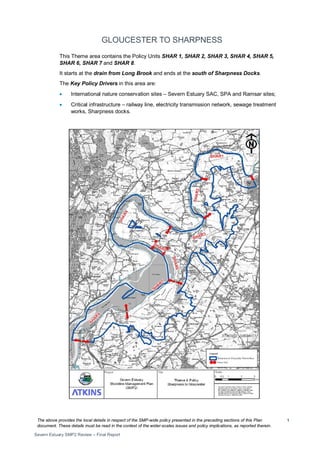
GLOUCESTER TO SHARPNESS
This Theme area contains the Policy Units SHAR 1, SHAR 2, SHAR 3, SHAR 4, SHAR 5,
SHAR 6, SHAR 7 and SHAR 8.
It starts at the drain from Long Brook and ends at the south of Sharpness Docks.
The Key Policy Drivers in this area are:
• International nature conservation sites – Severn Estuary SAC, SPA and Ramsar sites;
• Critical infrastructure – railway line, electricity transmission network, sewage treatment
works, Sharpness docks.
2. The above provides the local details in respect of the SMP-wide policy presented in the preceding sections of this Plan
document. These details must be read in the context of the wider-scales issues and policy implications, as reported therein.
Severn Estuary SMP2 Review – Final Report
2
3. The above provides the local details in respect of the SMP-wide policy presented in the preceding sections of this Plan
document. These details must be read in the context of the wider-scales issues and policy implications, as reported therein.
Severn Estuary SMP2 Review – Final Report
3
Policy Unit: SHAR 1 – Severn Farm to Wick’s Green (east bank of the
River Severn)
4. The above provides the local details in respect of the SMP-wide policy presented in the preceding sections of this Plan
document. These details must be read in the context of the wider-scales issues and policy implications, as reported therein.
Severn Estuary SMP2 Review – Final Report
4
Preferred Policies to Implement the Plan:
Epoch
Preferred
Policy
Comments
0 to 20
years
(2025)
HTL
The Short Term policy for this unit is Hold the Line.
Prior to MR in the second epoch, existing defences should be maintained. ..
HTL is not intended to allow new defences to be built along currently
undefended parts of the shoreline in this area.
HTL does not guarantee funding to build or maintain current or future
defences or to counter sea level rise.
20 to 50
years
(2055)
MR
The medium term policy for this unit is Managed Realignment.
The existing defences will come to the end of their serviceable life in this
epoch and a new, realigned defence should be constructed to create new
intertidal habitat. The position, size and materials of new defences should be
considered in detail to ensure MR does not impact on the risk of flooding to
developed areas, internal drainage or the linked Policy Units (GLO 6, GLO 7,
GLO 8 and SHAR 2).
The precise location and type of defence should be determined by the
SEFRMS. This should also determine whether MR should be phased over
this epoch and the next. MR will manage the risk of impacts from flooding
and erosion to assets behind the new defences.
Land, nature conservation and historic environment features in front of the
new line of defences or in areas of NAI will be at increased risk of flooding
and erosion. Adaptation actions should be considered and implemented.
The habitat created in this Policy Unit will help compensate for areas lost
elsewhere in the estuary and help maintain/improve the condition of the
European protected sites.
MR does not guarantee funding to build or maintain new realigned defences.
50 to 100
years
(2105)
MR
The long term policy for this unit is Managed Realignment.
New realigned defences should be maintained. If MR is being undertaken in
a phased manner, the second phase should take place in this epoch. MR will
manage the risk of impacts from flooding and erosion to assets behind the
new defences.
MR does not guarantee funding to build or maintain new realigned defences.
5. The above provides the local details in respect of the SMP-wide policy presented in the preceding sections of this Plan
document. These details must be read in the context of the wider-scales issues and policy implications, as reported therein.
Severn Estuary SMP2 Review – Final Report
5
Economics
Policy
Unit
Existing
SMP1
Policy
Time Period
(epoch)
SMP2 Assessment
0-
20
20-
50
50-
100
Preferred Plan Present Value
Damages
Preferred Plan Present Value
Defence Costs
SHAR
1
HTL HTL MR MR
£24m
(GLO6-8, SHAR1-2 total)
£10m
(GLO6-8, SHAR1-2 total)
The preferred policy is economically viable for the linked Policy Units of GLO 6, GLO 7, GLO 8, SHAR 1,
and SHAR 2, but the benefit-cost ratio (BCR) is low. Where the BCR is low, schemes may be less likely to
receive public funding and it may be necessary to find funding from other sources. The costs and damages
of the preferred policy in the table above relate to actions taken in linked policy units.
6. The above provides the local details in respect of the SMP-wide policy presented in the preceding sections of this Plan
document. These details must be read in the context of the wider-scales issues and policy implications, as reported therein.
Severn Estuary SMP2 Review – Final Report
6
Predicted Implication of the Preferred Plan for the SHAR 1 Policy Unit
Time
Period
Management Activities
Property, Land Use and
Human Health
Nature Conservation –
including Earth
Heritage, Geology and
Biodiversity
Landscape Character
and Visual Amenity
Historic Environment
Amenity and
Recreational Use
0 – 20
years
The existing defence line
should be maintained
until a new realigned
defence line is created in
the next epoch.
The existing flood defences
will continue to reduce the
risk to existing properties
and land in this epoch.
There will be limited
impact in this epoch as
the existing defence
line gradually
deteriorates over time.
Works should take
account of possible
environmental impacts
and the need for an
EIA.
Limited erosion and
flood risk will not impact
on existing landscape
and visual amenity
Limited erosion and flood
risk will not impact on the
historic environment.
Limited erosion and flood
risk will not impact on the
amenity value of the land
or recreational use.
20 – 50
years
Defences are expected
to come to the end of
their serviceable life.
Prior to complete failure
of the existing defences,
a new realigned earth
embankment should be
established to allow
habitat creation and to
reduce the risk of
impacts from fluvial
flooding by increasing
floodwater conveyance
A total of 156 Ha of
agricultural land will be
undefended and will be
subject to frequent flood risk.
Erosion in this section of the
estuary is limited. Realigned
defences will manage the
risk to properties and land
behind new defences.
Assets in front of realigned
defences will be at risk from
inundation. Impacts on
property and land, and
mitigation actions will need
to be considered in
determining realignment of
defences
A MR policy will allow
the creation of
approximately 156 Ha
of additional intertidal
habitat. However there
may be loss of
terrestrial habitats as
intertidal habitats roll
back. Works should
take account of
possible environmental
impacts and the need
for an EIA.
The creation of intertidal
habitat will replace
existing agricultural
land, altering the
landscape.
Realigned defences will
manage the risk of impacts
to historic environment
assets behind new
defences. Assets in front of
realigned defences will be
at risk from inundation.
Managed re-alignment is
likely to adversely impact
on a limited number of
listed buildings. Impacts on
historic environment
assets, and mitigation
actions, will need to be
considered in determining
realignment of defences
Realigned defences will
manage the risk on the
amenity value or
recreational use of the
land behind new
defences. . Impacts on
recreational assets, and
mitigation actions, will
need to be considered in
determining realignment
of defences
7. The above provides the local details in respect of the SMP-wide policy presented in the preceding sections of this Plan
document. These details must be read in the context of the wider-scales issues and policy implications, as reported therein.
Severn Estuary SMP2 Review – Final Report
7
Time
Period
Management Activities
Property, Land Use and
Human Health
Nature Conservation –
including Earth
Heritage, Geology and
Biodiversity
Landscape Character
and Visual Amenity
Historic Environment
Amenity and
Recreational Use
50 – 100
years
The new defence line
should be maintained.
The second phase of MR
should take place in this
epoch if a phased
approach is being
implemented
Realigned defences will
manage the risk to
properties and land behind
new defences.
A MR policy will allow
the creation of
approximately 156 Ha
of additional intertidal
habitat. However there
may be loss of
terrestrial habitats as
intertidal habitats roll
back. Works should
take account of
possible environmental
impacts and the need
for an EIA.
In the long term sea
level rise will result in
more frequent flooding
of the seaward side of
the defence line and
creation of intertidal
habitat, altering the
landscape.
Realigned defences will
manage the risk of impacts
to historic environment
assets behind new
defences. Assets in front of
realigned defences will be
at risk from inundation.
Managed re-alignment is
likely to adversely impact
on a limited number of
listed buildings. Impacts on
historic environment
assets, and mitigation
actions, will need to be
considered in determining
realignment of defences
Realigned defences will
manage the risk on the
amenity value or
recreational use of the
land behind new
defences.
8. The above provides the local details in respect of the SMP-wide policy presented in the preceding sections of this Plan
document. These details must be read in the context of the wider-scales issues and policy implications, as reported therein.
Severn Estuary SMP2 Review – Final Report
8
Policy Unit: SHAR 2 – Wick’s Green to Longley Green (east bank of the
River Severn)
9. The above provides the local details in respect of the SMP-wide policy presented in the preceding sections of this Plan
document. These details must be read in the context of the wider-scales issues and policy implications, as reported therein.
Severn Estuary SMP2 Review – Final Report
9
Preferred Policies to Implement the Plan:
Epoch
Preferred
Policy
Comments
0 to 20
years
(2025)
HTL
The Short Term policy for this unit is Hold the Line.
Prior to MR in the second epoch, existing defences should be maintained.
HTL is not intended to allow new defences to be built along currently
undefended parts of the shoreline in this Policy Unit.
HTL does not guarantee funding to build or maintain current or future
defences or to counter sea level rise.
20 to 50
years
(2055)
MR
The medium term policy for this unit is a Managed Realignment policy.
The existing defences will come to the end of their serviceable life in this
epoch and a new, realigned defence should be constructed to enable new
intertidal habitat to be created. The position, size and materials of new
defences should be considered in detail to ensure MR does not impact on
the risk of flooding to developed areas, internal drainage or the linked Policy
Units (GLO 6, GLO 7, GLO 8 and SHAR 1). Improvements to the way
flooding from river sources flows through the area (flood conveyance) should
also be considered. The precise location and type of defence should be
determined by the SEFRMS.
MR will manage the risk of impacts from flooding and erosion to assets
behind the new defences.
Land, nature conservation and historic environment features in front of the
new line of defences or in areas of NAI will be at increased risk of flooding
and erosion. Adaptation actions should be considered and implemented.
The habitat created in this Policy Unit will help compensate for areas lost
elsewhere in the estuary and help maintain/improve the condition of the
European protected sites.
MR does not guarantee funding to build or maintain new realigned defences.
50 to 100
years
(2105)
HTL
The long term policy for this unit is a Hold The Line policy.
New realigned defences should be maintained. HTL will manage the risk of
impacts from flooding and erosion to assets behind the new defences.
HTL does not guarantee funding to build or maintain current or future
defences or to counter sea level rise.
10. The above provides the local details in respect of the SMP-wide policy presented in the preceding sections of this Plan
document. These details must be read in the context of the wider-scales issues and policy implications, as reported therein.
Severn Estuary SMP2 Review – Final Report
10
Economics
Policy
Unit
Existing
SMP1
Policy
Time Period
(epoch)
SMP2 Assessment
0-
20
20-
50
50-
100
Preferred Plan Present Value
Damages
Preferred Plan Present Value
Defence Costs
SHAR
2
HTL HTL MR HTL
£24m
(GLO6-8, SHAR1-2 total)
£10m
(GLO6-8, SHAR1-2 total)
The preferred policy is economically viable for the linked Policy Units of GLO 6, GLO 7, GLO 8, SHAR 1,
and SHAR 2, but the benefit-cost ratio (BCR) is low. Where the BCR is low, schemes may be less likely to
receive public funding and it may be necessary to find funding from other sources. The costs and damages
of the preferred policy in the table above relate to actions taken in linked policy units.
11. The above provides the local details in respect of the SMP-wide policy presented in the preceding sections of this Plan
document. These details must be read in the context of the wider-scales issues and policy implications, as reported therein.
Severn Estuary SMP2 Review – Final Report
11
Predicted Implication of the Preferred Plan for the SHAR 2 Policy Unit
Time
Period
Management Activities
Property, Land Use and
Human Health
Nature Conservation –
including Earth
Heritage, Geology and
Biodiversity
Landscape Character
and Visual Amenity
Historic Environment
Amenity and
Recreational Use
0 – 20
years
The existing defence line
will should be maintained
until a new realigned
defence is created.
The existing flood
defences will continue to
reduce the risk to existing
properties and land in this
epoch.
There will be limited
impact in this epoch as
the existing defence line
is maintained. Works
should take account of
possible environmental
impacts and the need for
an EIA.
Limited erosion and
flood risk will not impact
on existing landscape
and visual amenity.
Limited erosion and flood
risk will not impact on the
historic environment.
Limited erosion and flood
risk will not impact on the
amenity value of the land
or recreational use.
20 – 50
years
Prior to the failure of the
existing defences, a new
earth embankment
should be established
A total of 352 Ha of
agricultural land will be
undefended and will be
subject to frequent flood
risk. Erosion in this section
of the estuary is limited.
Realigned defences will
manage the risk to
properties and land behind
new defences. Assets in
front of realigned defences
will be at risk from
inundation. Impacts on
property and land, and
mitigation actions will need
to be considered in
determining realignment of
defences.
A MR policy will allow the
creation of approximately
352 Ha of additional
intertidal habitat. There
will be loss of terrestrial
habitats as intertidal
habitats roll back. Works
should take account of
possible environmental
impacts and the need for
an EIA.
The creation of intertidal
habitat will replace
existing agricultural
land, altering the
landscape.
Realigned defences will
manage the risk of impacts
from flooding to historic
environment assets behind
new defences. Assets in
front of realigned defences
will be at risk from
inundation. Managed re-
alignment is likely to
adversely impact on a
limited number of listed
buildings. Impacts on
historic environment
assets, and mitigation
actions, will need to be
considered in determining
realignment of defences
Realigned defences will
manage the risk on the
amenity value or
recreational use of the
land behind new
defences. Impacts on
recreational assets, and
mitigation actions, will
need to be considered in
determining realignment
of defences
12. The above provides the local details in respect of the SMP-wide policy presented in the preceding sections of this Plan
document. These details must be read in the context of the wider-scales issues and policy implications, as reported therein.
Severn Estuary SMP2 Review – Final Report
12
Time
Period
Management Activities
Property, Land Use and
Human Health
Nature Conservation –
including Earth
Heritage, Geology and
Biodiversity
Landscape Character
and Visual Amenity
Historic Environment
Amenity and
Recreational Use
50 – 100
years
The new defence line
should be maintained.
Realigned defences will
manage the risk to
properties and land behind
new defences.
A MR policy will allow the
creation of approximately
352 Ha of additional
intertidal habitat. There
will be loss of terrestrial
habitats as intertidal
habitats roll back. Works
should take account of
possible environmental
impacts and the need for
an EIA.
In the long term sea
level rise will result in
more frequent flooding
of the seaward side of
the defence line and
creation of intertidal
habitat, altering the
landscape.
Realigned defences will
manage the risk of impacts
from flooding to historic
environment assets behind
new defences. Assets in
front of realigned defences
will be at risk from
inundation. Managed re-
alignment is likely to
adversely impact on a
limited number of listed
buildings. Impacts on
historic environment
assets, and mitigation
actions, will need to be
considered in determining
realignment of defences
Realigned defences will
manage the risk on the
amenity value or
recreational use of the
land behind new
defences.
13. The above provides the local details in respect of the SMP-wide policy presented in the preceding sections of this Plan
document. These details must be read in the context of the wider-scales issues and policy implications, as reported therein.
Severn Estuary SMP2 Review – Final Report
13
Policy Unit: SHAR 3 – Longley Green to Overton Lane (east bank of
the River Severn)
14. The above provides the local details in respect of the SMP-wide policy presented in the preceding sections of this Plan
document. These details must be read in the context of the wider-scales issues and policy implications, as reported therein.
Severn Estuary SMP2 Review – Final Report
14
Preferred Policies to Implement the Plan:
Epoch
Preferred
Policy
Comments
0 to 20
years
(2025)
HTL
The Short Term policy for this unit is Hold The Line.
The current defences are expected to remain in place for this epoch but may
require some reconstruction / extensive works during this epoch. HTL will
manage the risk of impacts from flooding in this epoch.
It is part of 8 linked Policy Units (GLO3, GLO 4, GLO 5, SHAR 3, SHAR 4,
SHAR 5, SHAR 6, and SHAR 7). Actions should take account of potential
impacts in all linked areas.
HTL does not guarantee funding to build or maintain current or future
defences or to counter sea level rise.
20 to 50
years
(2055)
HTL
The medium term policy for this unit is Hold The Line.
The existing defences will come to the end of their serviceable life in this
epoch. HTL recommends that defences are replaced. The position, size
and materials of new defences should be considered in detail to ensure
actions take account of potential impacts on linked Policy Units (GLO3, GLO
4, GLO 5, SHAR 3, SHAR 4, SHAR 5, SHAR 6, and SHAR 7). The precise
location and type of defence should be determined by the SEFRMS. HTL
will manage the risk of impacts from flooding.
Where there are currently no defences, investigation should be carried out to
find out if new defences are needed or if other actions could reduce the risk
of flooding from coastal flooding.
HTL does not guarantee funding to build or maintain current or future
defences or to counter sea level rise.
50 to 100
years
(2105)
HTL
The long term policy for this unit is Hold The Line.
New defences should be maintained. HTL will manage the risk of impacts
from flooding in this and linked Policy Units (GLO3, GLO 4, GLO 5, SHAR 3,
SHAR 4, SHAR 5, SHAR 6, and SHAR 7).
HTL does not guarantee funding to build or maintain current or future
defences or to counter sea level rise.
Economics
Policy
Unit
Existing
SMP1
Policy
Time Period
(epoch)
SMP2 Assessment
0-
20
20-
50
50-
100
Preferred Plan Present Value
Damages
Preferred Plan Present Value
Defence Costs
SHAR
3
HTL HTL HTL HTL
£124m
(GLO3-5, SHAR3-7 total)
£23m
(GLO3-5, SHAR3-7 total)
The preferred policy is economically viable for this unit. The preferred policy is economically viable for the
linked Policy Units of GLO 3, GLO 4, GLO 5, SHAR 3, SHAR 4, SHAR 5, SHAR 6 and SHAR 7. The costs
and damages of the preferred policy in the table above relate to actions taken in linked policy units.
15. The above provides the local details in respect of the SMP-wide policy presented in the preceding sections of this Plan
document. These details must be read in the context of the wider-scales issues and policy implications, as reported therein.
Severn Estuary SMP2 Review – Final Report
15
Predicted Implication of the Preferred Plan for the SHAR 3 Policy Unit
Time
Period
Management Activities
Property, Land Use and
Human Health
Nature Conservation –
including Earth
Heritage, Geology and
Biodiversity
Landscape Character
and Visual Amenity
Historic Environment
Amenity and
Recreational Use
0 – 20
years
The current earth
embankment defences
are expected to come to
the end of their
serviceable life during the
next epoch but may
require reconstruction /
extensive works during
this epoch.
Defences will manage the
risk of impacts from
flooding to existing
property, land use or
human health.
A HTL policy will not
significantly impact on
nature conservation sites.
Works should take
account of possible
environmental impacts
and the need for an EIA.
Defences are likely to
come to the end of their
serviceable life in the next
epoch but may require
reconstruction / extensive
works during this epoch.
Increased height of
defences or change in
defence construction
materials will affect local
landscape - increasing
presence in the
landscape and disrupting
views.
Defences will manage the
risk of impacts from
flooding to the historic
environment
Defences will manage the
risk to amenity or
recreational value of the
land.
20 – 50
years
The current earth
embankment defences
are expected to come to
the end of their
serviceable life during this
epoch and should be
replaced. A maintenance
programme should be
established to ensure the
defences continue to
function.
Defences will manage the
risk of impacts from
flooding to existing
property, land use or
human health.
Coastal squeeze may
occur which will result in
loss of intertidal habitats.
Works should take
account of possible
environmental impacts
and the need for an EIA.
Defences are likely to
come to the end of their
serviceable life in this
epoch. Increased height
of defences or change in
defence construction
materials will affect local
landscape - increasing
presence in the
landscape and disrupting
views.
Defences will manage the
risk of impacts from
flooding to the historic
environment
Defences will manage the
risk to amenity or
recreational value of the
land.
50 – 100
years
An on-going maintenance
programme should be
established including the
monitoring of shoreline
erosion as sea level rise
increases.
Defences will manage the
risk of impacts from
flooding to existing
property, land use or
human health.
Coastal squeeze may
occur which will result in
loss of intertidal habitats.
Works should take
account of possible
environmental impacts
and the need for an EIA.
Increased height of
defences or change in
defence construction
materials will affect local
landscape - increasing
presence in the
landscape and disrupting
views.
Defences will manage the
risk of impacts from
flooding to the historic
environment
Defences will manage the
risk to amenity or
recreational value of the
land.
16. The above provides the local details in respect of the SMP-wide policy presented in the preceding sections of this Plan
document. These details must be read in the context of the wider-scales issues and policy implications, as reported therein.
Severn Estuary SMP2 Review – Final Report
16
Policy Unit: SHAR 4 – Overton Lane to Hock Cliff (east bank of the
River Severn)
17. The above provides the local details in respect of the SMP-wide policy presented in the preceding sections of this Plan
document. These details must be read in the context of the wider-scales issues and policy implications, as reported therein.
Severn Estuary SMP2 Review – Final Report
17
Preferred Policies to Implement the Plan:
Epoch
Preferred
Policy
Comments
0 to 20
years
(2025)
HTL
The Short Term policy for this unit is Hold the Line.
Prior to MR in the second epoch, existing defences should be maintained.
Current defences may require extensive maintenance works.
HTL is not intended to allow new defences to be built along currently
undefended parts of the shoreline in this Policy Unit.
HTL does not guarantee funding to build or maintain current or future
defences or to counter sea level rise.
20 to 50
years
(2055)
MR
The medium term policy for this unit is Managed Realignment.
The existing defences will come to the end of their serviceable life in this
epoch and a new, realigned defence should be constructed to enable new
intertidal habitat to be created. The position, size and materials of new
defences should be considered in detail.
MR should contribute to reducing the risk of flooding in linked Policy Units,
not increase it (GLO3, GLO 4, GLO 5, SHAR 3, SHAR 5, SHAR 6, and
SHAR 7). Improvements to the way flooding from river sources flows
through the area (flood conveyance) should also be considered. The precise
location and type of defence should be determined by the SEFRMS. MR
manages the risk of impacts from flooding and erosion behind the new
defences.
Land, nature conservation and historic environment features in front of the
new line of defences will be at increased risk of flooding and erosion.
Adaptation actions should be considered and implemented where
appropriate. The habitat created in this Policy Unit will help compensate for
areas lost elsewhere in the estuary and help maintain/improve the condition
of the European protected sites.
MR does not guarantee funding to build or maintain new realigned defences.
50 to 100
years
(2105)
MR
The long term policy for this unit is Managed Realignment.
New realigned defences should be maintained. A second phase of could be
undertaken in this epoch to further set back defences. MR manages the risk
of impacts from flooding and erosion behind the new defences.
MR does not guarantee funding to build or maintain new realigned defences.
18. The above provides the local details in respect of the SMP-wide policy presented in the preceding sections of this Plan
document. These details must be read in the context of the wider-scales issues and policy implications, as reported therein.
Severn Estuary SMP2 Review – Final Report
18
Economics
Policy
Unit
Existing
SMP1
Policy
Time Period
(epoch)
SMP2 Assessment
0-
20
20-
50
50-
100
Preferred Plan Present Value
Damages
Preferred Plan Present Value
Defence Costs
SHAR
4
HTL HTL MR MR
£124m
(GLO3-5, SHAR3-7 total)
£23m
(GLO3-5, SHAR3-7 total)
The preferred policy is economically viable for the linked Policy Units of GLO 3, GLO 4, GLO 5, SHAR 3,
SHAR 4, SHAR 5, SHAR 6 and SHAR 7. The costs and damages of the preferred policy in the table above
relate to actions taken in linked policy units.
19. The above provides the local details in respect of the SMP-wide policy presented in the preceding sections of this Plan
document. These details must be read in the context of the wider-scales issues and policy implications, as reported therein.
Severn Estuary SMP2 Review – Final Report
19
Predicted Implication of the Preferred Plan for the SHAR 4 Policy Unit
Time
Period
Management Activities
Property, Land Use and
Human Health
Nature Conservation –
including Earth
Heritage, Geology and
Biodiversity
Landscape Character
and Visual Amenity
Historic Environment
Amenity and
Recreational Use
0 – 20
years
The existing defence line
should be maintained
until a new realigned
defence line is created.
The existing flood
defences will continue to
reduce the risk to existing
properties and land in this
epoch.
There will be limited
impact in this epoch as
the existing defence line
gradually deteriorates
over time. Works should
take account of possible
environmental impacts
and the need for an EIA.
Limited erosion and
flood risk will not impact
on existing landscape
and visual amenity.
Limited erosion and flood
risk will not impact on the
historic environment.
Limited erosion and
flood risk will not impact
on the amenity value of
the land or recreational
use.
20 – 50
years
Prior to complete failure
of the existing earth
embankment, new
defences, should be
established to allow
habitat creation and to
reduce the impact from
fluvial flooding by
increasing floodwater
conveyance.
A total of 409 Ha of
agricultural land will be
undefended and will be
subject to frequent flood
risk. Erosion in this section
of the estuary is limited.
Realigned defences will
manage the risk to
properties and land behind
new defences. Assets in
front of realigned defences
will be at risk from
inundation. Impacts on
property and land, and
mitigation actions will need
to be considered in
determining realignment of
defences.
A MR policy will allow
the creation of
approximately 409 Ha of
additional intertidal
habitat. There will be
loss of terrestrial habitats
as intertidal habitats roll
back. Works should take
account of possible
environmental impacts
and the need for an EIA.
The creation of intertidal
habitat will replace
existing agricultural
land, altering the
landscape.
Realigned defences will
manage the risk to historic
environment assets behind
new defences. Assets in
front of realigned defences
will be at risk from
inundation. Managed re-
alignment is likely to
adversely impact on a
limited number of listed
buildings. Impacts on
historic environment assets,
and mitigation actions, will
need to be considered in
determining realignment of
defences
Realigned defences will
manage the risk on the
amenity value or
recreational use of the
land behind new
defences. Impacts on
recreational assets, and
mitigation actions, will
need to be considered in
determining realignment
of defences
20. The above provides the local details in respect of the SMP-wide policy presented in the preceding sections of this Plan
document. These details must be read in the context of the wider-scales issues and policy implications, as reported therein.
Severn Estuary SMP2 Review – Final Report
20
Time
Period
Management Activities
Property, Land Use and
Human Health
Nature Conservation –
including Earth
Heritage, Geology and
Biodiversity
Landscape Character
and Visual Amenity
Historic Environment
Amenity and
Recreational Use
50 – 100
years
The new defence line
should be maintained. A
second phase of MR
could be undertaken to
further set back defences
and create more intertidal
habitat.
Realigned defences will
manage the risk to
properties and land behind
new defences.
A MR policy will allow
the creation of
approximately 409 Ha of
additional intertidal
habitat. There will be
loss of terrestrial habitats
as intertidal habitats roll
back. Works should take
account of possible
environmental impacts
and the need for an EIA.
In the long term sea
level rise will result in
more frequent flooding
of the seaward side of
the defence line and
creation of intertidal
habitat, altering the
landscape.
Realigned defences will
manage the risk to historic
environment assets behind
new defences. Assets in
front of realigned defences
will be at risk from
inundation. Managed re-
alignment is likely to
adversely impact on a
limited number of listed
buildings. Impacts on
historic environment assets,
and mitigation actions, will
need to be considered in
determining realignment of
defences
Realigned defences will
manage the risk on the
amenity value or
recreational use of the
land behind new
defences.
21. The above provides the local details in respect of the SMP-wide policy presented in the preceding sections of this Plan
document. These details must be read in the context of the wider-scales issues and policy implications, as reported therein.
Severn Estuary SMP2 Review – Final Report
21
Policy Unit: SHAR 5 – Hock Cliff (east bank of the River Severn)
22. The above provides the local details in respect of the SMP-wide policy presented in the preceding sections of this Plan
document. These details must be read in the context of the wider-scales issues and policy implications, as reported therein.
Severn Estuary SMP2 Review – Final Report
22
Preferred Policies to Implement the Plan:
Epoch
Preferred
Policy
Comments
0 to 20
years
(2025)
NAI
The short term policy for this unit is No Active Intervention.
High ground and hard geology naturally limit the risk of coastal flooding and
erosion in this Policy Unit.
NAI will allow natural processes to continue on Hock Cliff (RIGS) with little /
no impact to any assets along the top of the cliff.
20 to 50
years
(2055) NAI
The medium term policy for this unit is No Active Intervention.
High ground and hard geology naturally limit the risk of coastal flooding and
erosion in this Policy Unit.
NAI will allow natural processes to continue on Hock Cliff (RIGS) with little /
no impact to any assets along the top of the cliff.
50 to 100
years
(2105) NAI
The long term policy for this unit is No Active Intervention.
High ground and hard geology naturally limit the risk of coastal flooding and
erosion in this Policy Unit.
NAI will allow natural processes to continue on Hock Cliff (RIGS) with little /
no impact to any assets along the top of the cliff.
In the long term, the rate of erosion should be monitored. If the rate of
erosion increases, or assets are at risk, action should be considered. Any
actions should take account of impacts on linked Policy Units (GLO3, GLO 4,
GLO 5, SHAR 3, SHAR 4, SHAR 6, and SHAR 7).
Economics
Policy
Unit
Existing
SMP1
Policy
Time Period
(epoch)
SMP2 Assessment
0-
20
20-
50
50-
100
Preferred Plan Present Value
Damages
Preferred Plan Present Value
Defence Costs
SHAR
5
Do
nothing
NAI NAI NAI
£124m
(GLO3-5, SHAR3-7 total)
£23m
(GLO3-5, SHAR3-7 total)
The preferred policy has no economic impact in this Policy Unit. The preferred policy is economically
viable for the linked Policy Units of GLO 3, GLO 4, GLO 5, SHAR 3, SHAR 4, SHAR 5, SHAR 6 and SHAR
7. The costs of the preferred policy in the table above relate to actions taken in linked policy units, not in
SHAR 5.
23. The above provides the local details in respect of the SMP-wide policy presented in the preceding sections of this Plan
document. These details must be read in the context of the wider-scales issues and policy implications, as reported therein.
Severn Estuary SMP2 Review – Final Report
23
Predicted Implication of the Preferred Plan for the SHAR 5 Policy Unit
Time
Period
Management Activities
Property, Land Use and
Human Health
Nature Conservation –
including Earth
Heritage, Geology and
Biodiversity
Landscape Character
and Visual Amenity
Historic Environment
Amenity and
Recreational Use
0 – 20
years
The cliffs will remain
stable in this period, and
as a result management
activities will be very
limited.
Limited erosion and flood
risk will not impact on
existing property, land
use or human health.
A NAI policy will allow the
continued exposure of
Hock Cliffs
Limited erosion and flood
risk will not impact on
existing landscape and
visual amenity
Limited erosion and flood
risk will not impact on the
historic environment
Limited erosion and flood
risk will not impact on the
amenity value of the land
or recreational use.
20 – 50
years
The cliffs will undergo
limited erosion within this
period, and as a result
management activities
will be very limited.
Limited erosion and flood
risk will not impact on
existing property, land
use or human health.
A NAI policy will allow the
continued exposure of
Hock Cliffs. High ground
will prevent roll back of
habitats – intertidal
habitat lost to coastal
squeeze.
Limited erosion and flood
risk will not impact on
existing landscape and
visual amenity
Limited erosion and flood
risk will not impact on the
historic environment
Limited erosion and flood
risk will not impact on the
amenity value of the land
or recreational use.
50 – 100
years
The cliffs will undergo
limited erosion within this
period, and as a result
management activities
will be very limited.
Limited erosion and flood
risk will not impact on
existing property, land
use or human health.
A NAI policy will allow the
continued exposure of
Hock Cliffs. High ground
will prevent roll back of
habitats – intertidal
habitat lost to coastal
squeeze.
Limited erosion and flood
risk will not impact on
existing landscape and
visual amenity
Limited erosion and flood
risk will not impact on the
historic environment
Limited erosion and flood
risk will not impact on the
amenity value of the land
or recreational use.
24. The above provides the local details in respect of the SMP-wide policy presented in the preceding sections of this Plan
document. These details must be read in the context of the wider-scales issues and policy implications, as reported therein.
Severn Estuary SMP2 Review – Final Report
24
Policy Unit: SHAR 6 – Hock Cliff to Frampton Pill (east bank of River
Severn)
25. The above provides the local details in respect of the SMP-wide policy presented in the preceding sections of this Plan
document. These details must be read in the context of the wider-scales issues and policy implications, as reported therein.
Severn Estuary SMP2 Review – Final Report
25
Preferred Policies to Implement the Plan:
Epoch
Preferred
Policy
Comments
0 to 20
years
(2025)
HTL
The short term policy for this unit is Hold The Line.
The current defences are expected to remain in place for this epoch but may
require some reconstruction / extensive works during this epoch. HTL
manages the risk of impacts from flooding in this epoch. Actions should take
account of potential impacts in all linked Policy Units (GLO3, GLO 4, GLO 5,
SHAR 3, SHAR 4, SHAR 5, SHAR 6, and SHAR 7).
HTL does not guarantee funding to build or maintain current or future
defences or to counter sea level rise.
20 to 50
years
(2055)
HTL
The medium term policy for this unit is Hold The Line.
The existing defences will come to the end of their serviceable life in this
epoch. HTL recommends that defences are replaced. The position, size
and materials of new defences should be considered in detail to ensure
actions take account of potential impacts on linked Policy Units (GLO3, GLO
4, GLO 5, SHAR 3, SHAR 4, SHAR 5, and SHAR 7).
The role that the Gloucester to Sharpness Canal can play in flood
management should be considered in determining the type and position of
new defences. The precise location and type of defence should be
determined by the SEFRMS. HTL manages the risk of impacts from flooding
in this and linked Policy Units.
Where there are currently no defences, investigation should be carried out to
find out if new defences are needed or if other actions could reduce the risk
of flooding from coastal flooding.
HTL does not guarantee funding to build or maintain current or future
defences or to counter sea level rise.
50 to 100
years
(2105)
HTL
The long term policy for this unit is Hold The Line.
New defences should be maintained. HTL manages the risk of impacts from
flooding in this and linked Policy Units (GLO3, GLO 4, GLO 5, SHAR 3,
SHAR 4, SHAR 5, SHAR 6, and SHAR 7).
HTL does not guarantee funding to build or maintain current or future
defences or to counter sea level rise.
26. The above provides the local details in respect of the SMP-wide policy presented in the preceding sections of this Plan
document. These details must be read in the context of the wider-scales issues and policy implications, as reported therein.
Severn Estuary SMP2 Review – Final Report
26
Economics
Policy
Unit
Existing
SMP1
Policy
Time Period
(epoch)
SMP2 Assessment
0-
20
20-
50
50-
100
Preferred Plan Present Value
Damages
Preferred Plan Present Value
Defence Costs
SHAR
6
HTL HTL HTL HTL
£124m
(GLO3-5, SHAR3-7 total)
£23m
(GLO3-5, SHAR3-7 total)
The preferred policy for this unit is economically viable. The preferred policy is economically viable for the
linked Policy Units of GLO 3, GLO 4, GLO 5, SHAR 3, SHAR 4, SHAR 5, SHAR 6 and SHAR 7. The costs
and damages of the preferred policy in the table above relate to actions taken in linked policy units.
27. The above provides the local details in respect of the SMP-wide policy presented in the preceding sections of this Plan
document. These details must be read in the context of the wider-scales issues and policy implications, as reported therein.
Severn Estuary SMP2 Review – Final Report
27
Predicted Implication of the Preferred Plan for the SHA 6 Policy Unit
Time
Period
Management Activities
Property, Land Use
and Human Health
Nature Conservation –
including Earth
Heritage, Geology and
Biodiversity
Landscape Character and
Visual Amenity
Historic
Environment
Amenity and
Recreational Use
0 – 20
years
The current earth
embankment defences are
expected to come to the
end of their serviceable life
during the next epoch but
may require replacement /
extensive works during this
epoch.
Defences will manage
the risk of impacts to
existing property, land
use or human health.
A HTL policy will not
impact the nature
conservation sites during
this time period. Works
should take account of
possible environmental
impacts and the need for
an EIA.
Defences are likely to come
to the end of their serviceable
life in the next epoch but may
require reconstruction /
extensive works during this
epoch. Increased height of
defences or change in
defence construction
materials will affect local
landscape - increasing
presence in the landscape
and disrupting views.
Defences will manage
the risk of impacts to
the historic
environment
Defences will manage the
risk to amenity or
recreational value of the
land and the canal
20 – 50
years
The current earth
embankment defences are
expected to come to the
end of their serviceable life
during this epoch and
should be replaced. A
maintenance programme
should be established to
ensure the defences afford
protection to the assets at
risk
Defences will manage
the risk of impacts to
existing property, land
use or human health.
A HTL policy may result
in coastal squeeze as sea
level rise increases. A
HTL policy will manage
the potential for saline
intrusion of Frampton
Pools. Works should take
account of possible
environmental impacts
and the need for an EIA.
Defences are likely to come
to the end of their serviceable
life in this epoch and should
be reconstructed. Increased
height of defences or change
in defence construction
materials will affect local
landscape - increasing
presence in the landscape
and disrupting views.
Defences will manage
the risk of impacts to
the historic
environment
Defences will manage the
risk to amenity or
recreational value of the
land and the canal
50 – 100
years
An on-going maintenance
programme should be
established including the
monitoring of shoreline
erosion as sea level rise
increases.
Defences will manage
the risk of impacts to
existing property, land
use or human health.
A HTL policy may result
in coastal squeeze as sea
level rise increases. A
HTL policy will manage
the potential for saline
intrusion of Frampton
Pools. Works should take
account of possible
environmental impacts
and the need for an EIA.
Increased height of defences
or change in defence
construction materials will
affect local landscape -
increasing presence in the
landscape and disrupting
views.
Defences will manage
the risk of impacts to
the historic
environment
Defences will manage the
risk to amenity or
recreational value of the
land and the canal
28. The above provides the local details in respect of the SMP-wide policy presented in the preceding sections of this Plan
document. These details must be read in the context of the wider-scales issues and policy implications, as reported therein.
Severn Estuary SMP2 Review – Final Report
28
Policy Unit: SHAR 7 – Frampton Pill to Royal Drift outfall (east bank of
the River Severn)
29. The above provides the local details in respect of the SMP-wide policy presented in the preceding sections of this Plan
document. These details must be read in the context of the wider-scales issues and policy implications, as reported therein.
Severn Estuary SMP2 Review – Final Report
29
Preferred Policies to Implement the Plan:
Epoch
Preferred
Policy
Comments
0 to 20
years
(2025)
MR
The Short Term policy for this unit is Managed Realignment.
The current defences are expected to remain in place for this epoch and
gradually deteriorate. A new realigned defence line should be created to
enable new intertidal habitat to be created. Replacing defences in their
current location is not considered appropriate as it would result in coastal
squeeze. MR will manage the risk of impacts from flooding to assets behind
the new defences.
The position, size and materials of new defences should be considered in
detail by the SEFRMS. MR should contribute to reducing the risk of impacts
from flooding in linked Policy Units, not increase it (GLO3, GLO 4, GLO 5,
SHAR 3, SHAR 4, SHAR 5, and SHAR 6). The role that the Gloucester to
Sharpness Canal can play in flood management should be considered.
Land, nature conservation and historic environment features in front of the
new line of defences will be at increased risk of flooding and erosion -
adaptation actions should be considered / implemented where appropriate.
The habitat created in this Policy Unit will help compensate for areas lost
elsewhere in the estuary and help maintain/improve the condition of the
European protected sites.
MR does not guarantee funding to build or maintain new realigned defences.
20 to 50
years
(2055)
HTL
The medium term policy for this unit is Hold The Line.
New realigned defences should be maintained. HTL manages the risk of
impacts from flooding to assets behind the new defences.
HTL does not guarantee funding to build or maintain current or future
defences or to counter sea level rise.
50 to 100
years
(2105)
HTL
The long term policy for this unit is Hold The line.
New realigned defences should be maintained. HTL manages the risk of
impacts from flooding to assets behind the new defences.
HTL does not guarantee funding to build or maintain current or future
defences or to counter sea level rise.
30. The above provides the local details in respect of the SMP-wide policy presented in the preceding sections of this Plan
document. These details must be read in the context of the wider-scales issues and policy implications, as reported therein.
Severn Estuary SMP2 Review – Final Report
30
Economics
Policy
Unit
Existing
SMP1 Policy
Time Period
(epoch)
SMP2 Assessment
0-
20
20-
50
50-
100
Preferred Plan Present
Value Damages
Preferred Plan Present
Value Defence Costs
SHAR
7
HTL (or
Realignment)
MR HTL HTL
£124m
(GLO3-5, SHAR3-7 total)
£23m
(GLO3-5, SHAR3-7 total)
The preferred policy for this unit is economically viable. The preferred policy is economically viable for the
linked Policy Units of GLO 3, GLO 4, GLO 5, SHAR 3, SHAR 4, SHAR 5, SHAR 6 and SHAR 7. The costs
and damages of the preferred policy in the table above relate to actions taken in linked policy units.
31. The above provides the local details in respect of the SMP-wide policy presented in the preceding sections of this Plan
document. These details must be read in the context of the wider-scales issues and policy implications, as reported therein.
Severn Estuary SMP2 Review – Final Report
31
Predicted Implication of the Preferred Plan for the SHAR 7 Policy Unit
Time
Period
Management Activities
Property, Land Use and
Human Health
Nature Conservation –
including Earth
Heritage, Geology and
Biodiversity
Landscape Character
and Visual Amenity
Historic Environment
Amenity and
Recreational Use
0 – 20
years
The existing defence line
will not be maintained and
a new set back defence
line will be created to
allow habitat creation and
to reduce the impact from
fluvial flooding by
increasing floodwater
conveyance..
A total of 187 Ha of
agricultural land will be
undefended and will
subject to frequent
flooding. Erosion in this
area of the estuary is
limited. Realigned
defences will manage the
risk of impacts to
properties and land
behind new defences.
Assets in front of
realigned defences will be
at risk from inundation.
Impacts on property and
land, and mitigation
actions will need to be
considered in determining
realignment of defences.
A MR policy will allow the
creation of approximately
187 Ha of additional
intertidal habitat. There
will be loss of terrestrial
habitats as intertidal
habitats roll back. Works
should take account of
possible environmental
impacts and the need for
an EIA.
The creation of intertidal
habitat will replace
existing agricultural land,
altering the landscape.
Realigned defences will
manage the risk of
impacts to historic
environment assets
behind new defences.
Assets in front of
realigned defences will be
at risk from inundation.
Managed re-alignment is
likely to adversely impact
on a limited number of
listed buildings. Impacts
on historic environment
assets, and mitigation
actions, will need to be
considered in determining
realignment of defences
Realigned defences will
manage the risk on the
amenity value or
recreational use of the
land behind new
defences. Impacts on
recreational assets, and
mitigation actions, will
need to be considered in
determining realignment
of defences
20 – 50
years
The new defence line
should be maintained.
Realigned defences will
manage the risk of
impacts to properties and
land behind new
defences.
A MR policy will allow the
creation of approximately
187 Ha of additional
intertidal habitat. There
will be loss of terrestrial
habitats as intertidal
habitats roll back. Works
should take account of
possible environmental
impacts and the need for
an EIA.
The creation of intertidal
habitat will replace
existing agricultural land,
altering the landscape.
Realigned defences will
manage the risk of
impacts to historic
environment assets
behind new defences.
Assets in front of
realigned defences will be
at risk from inundation.
Managed re-alignment is
likely to adversely impact
on a limited number of
listed buildings.
Realigned defences will
manage the risk on the
amenity value or
recreational use of the
land behind new
defences.
32. The above provides the local details in respect of the SMP-wide policy presented in the preceding sections of this Plan
document. These details must be read in the context of the wider-scales issues and policy implications, as reported therein.
Severn Estuary SMP2 Review – Final Report
32
Time
Period
Management Activities
Property, Land Use and
Human Health
Nature Conservation –
including Earth
Heritage, Geology and
Biodiversity
Landscape Character
and Visual Amenity
Historic Environment
Amenity and
Recreational Use
50 – 100
years
The new defence line
should be maintained.
Realigned defences will
manage the risk of
impacts to properties and
land behind new
defences.
A MR policy will allow the
creation of approximately
187 Ha of additional
intertidal habitat. There
will be loss of terrestrial
habitats as intertidal
habitats roll back. Works
should take account of
possible environmental
impacts and the need for
an EIA.
In the long term sea level
rise will result in more
frequent flooding of the
seaward side of the
defence line and creation
of intertidal habitat,
altering the landscape.
Realigned defences will
manage the risk of
impacts to historic
environment assets
behind new defences.
Assets in front of
realigned defences will be
at risk from inundation.
Managed re-alignment is
likely to adversely impact
on a limited number of
listed buildings.
Realigned defences will
manage the risk on the
amenity value or
recreational use of the
land behind new
defences.
33. The above provides the local details in respect of the SMP-wide policy presented in the preceding sections of this Plan
document. These details must be read in the context of the wider-scales issues and policy implications, as reported therein.
Severn Estuary SMP2 Review – Final Report
33
Policy Unit: SHAR 8 – Royal Drift outfall to Sharpness Docks (east
bank of the River Severn)
34. The above provides the local details in respect of the SMP-wide policy presented in the preceding sections of this Plan
document. These details must be read in the context of the wider-scales issues and policy implications, as reported therein.
Severn Estuary SMP2 Review – Final Report
34
Preferred Policies to Implement the Plan:
Epoch
Preferred
Policy
Comments
0 to 20
years
(2025)
NAI
The short term policy for this unit is No Active Intervention.
High ground and hard geology naturally limit the risk of coastal flooding and
erosion in this Policy Unit. NAI will allow natural processes to continue. This
Policy Unit is not linked to any others.
20 to 50
years
(2055)
NAI
The medium term policy for this unit is No Active Intervention.
High ground and hard geology naturally limit the risk of coastal flooding and
erosion in this Policy Unit. NAI will allow natural processes to continue. This
Policy Unit is not linked to any others.
50 to 100
years
(2105)
NAI
The long term policy for this unit is No Active Intervention.
High ground and hard geology naturally limit the risk of coastal flooding and
erosion in this Policy Unit. NAI will allow natural processes to continue.
In the long term, the rate of erosion should be monitored. If the rate of
erosion increases, or assets are at risk, action should be considered. This
Policy Unit is not linked to any others.
Economics
Policy
Unit
Existing
SMP1
Policy
Time Period
(epoch)
SMP2 Assessment
0-
20
20-
50
50-
100
Preferred Plan Present Value
Damages
Preferred Plan Present Value
Defence Costs
SHAR
8
HTL NAI NAI NAI Minimal Minimal
The preferred policy has no economic impact. This Policy Unit is not linked to any others.
35. The above provides the local details in respect of the SMP-wide policy presented in the preceding sections of this Plan
document. These details must be read in the context of the wider-scales issues and policy implications, as reported therein.
Severn Estuary SMP2 Review – Final Report
35
Predicted Implication of the Preferred Plan for the SHAR 8 Policy Unit
Time
Period
Management Activities
Property, Land Use and
Human Health
Nature Conservation –
including Earth
Heritage, Geology and
Biodiversity
Landscape Character
and Visual Amenity
Historic Environment
Amenity and
Recreational Use
0 – 20
years
The shoreline will remain
stable in this period, and
as a result management
activities will be very
limited.
Limited erosion and flood
risk will not impact on
existing property, land
use or human health.
A NAI policy will allow
natural processes to
dominate. There will be
continued exposure of
Purton Passage SSSI.
Limited erosion and flood
risk will not impact on
existing landscape and
visual amenity
Limited erosion and flood
risk will not impact on the
historic environment
Limited erosion and flood
risk will not impact on the
amenity value of the land
or recreational use.
20 – 50
years
The shoreline will remain
stable in this period, and
as a result management
activities will be very
limited.
Limited erosion and flood
risk will not impact on
existing property, land
use or human health.
A NAI policy will allow
natural processes to
dominate. There will be
continued exposure of
Purton Passage SSSI.
Limited erosion and flood
risk will not impact on
existing landscape and
visual amenity
Limited erosion and flood
risk will not impact on the
historic environment
Limited erosion and flood
risk will not impact on the
amenity value of the land
or recreational use
including the canal
50 – 100
years
The shoreline will
undergo limited erosion
within this period, and as
a result management
activities will be very
limited. Due to the close
proximity of the canal
should erosion due to sea
level rise increase,
erosion protection
measures should be
considered.
Limited erosion and flood
risk will not impact on
existing property, land
use or human health.
A NAI policy will allow
natural processes to
dominate. There will be
continued exposure of
Purton Passage SSSI.
Limited erosion and flood
risk will not impact on
existing landscape and
visual amenity
Limited erosion and flood
risk will not impact on the
historic environment. In
the long term, actions
may be required to
preserve or collect
historic information from
Purton Hulks and the
canal
Limited erosion and flood
risk will not impact on the
amenity value of the land
or recreational use
including the canal