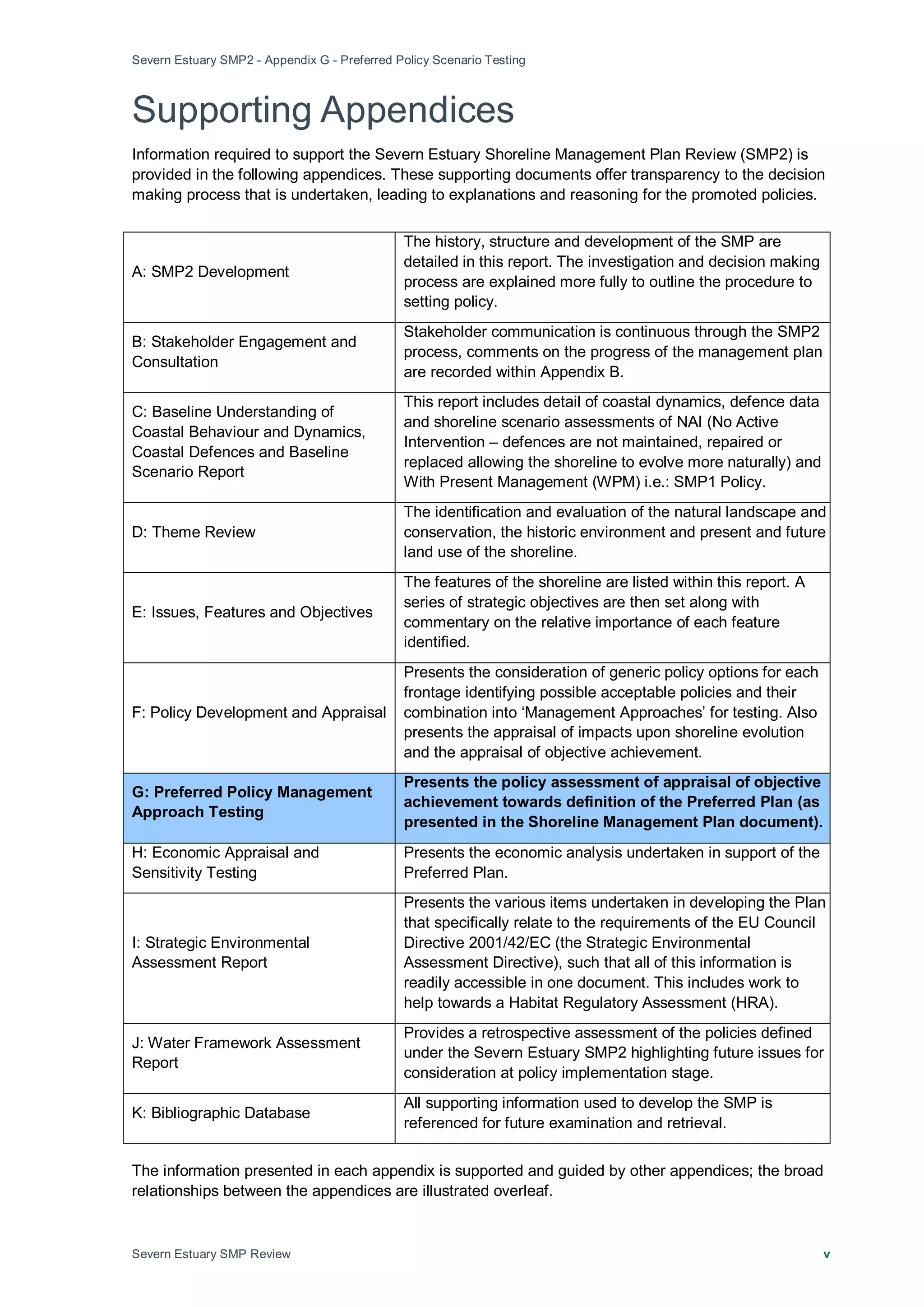
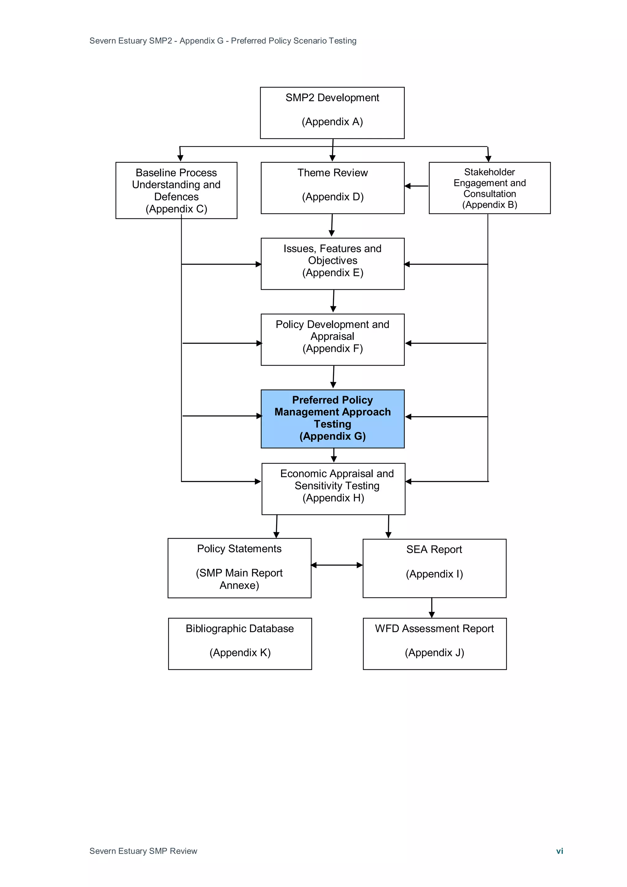
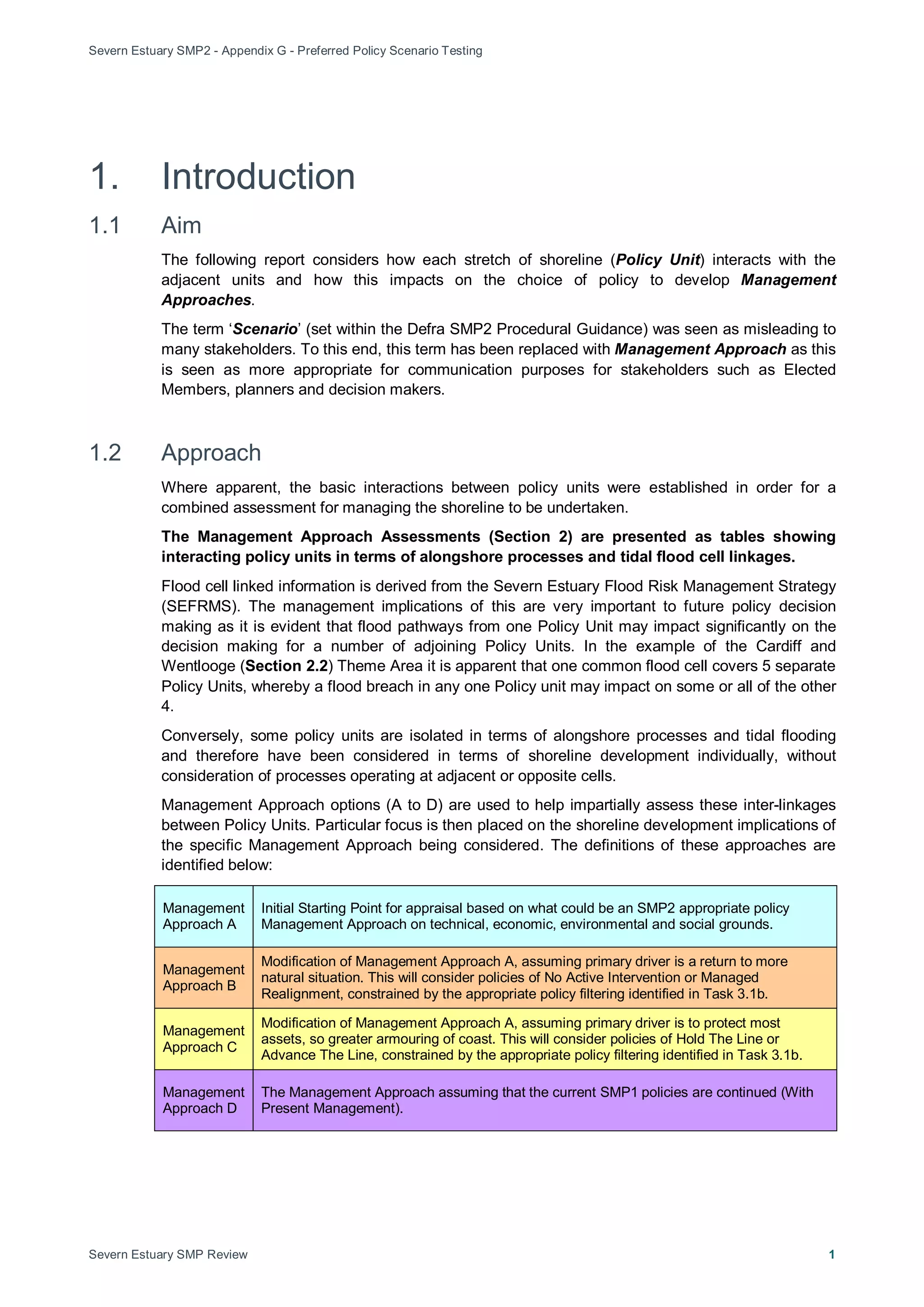
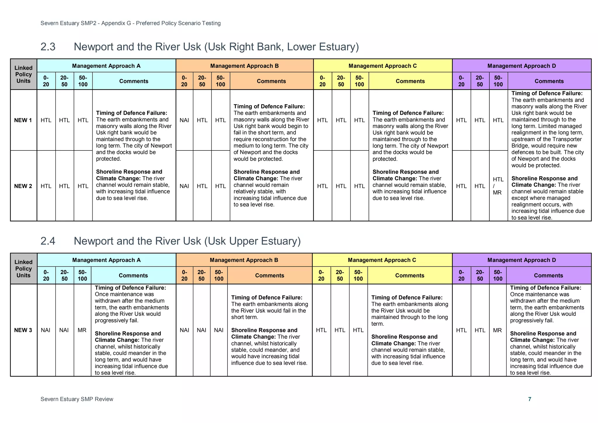
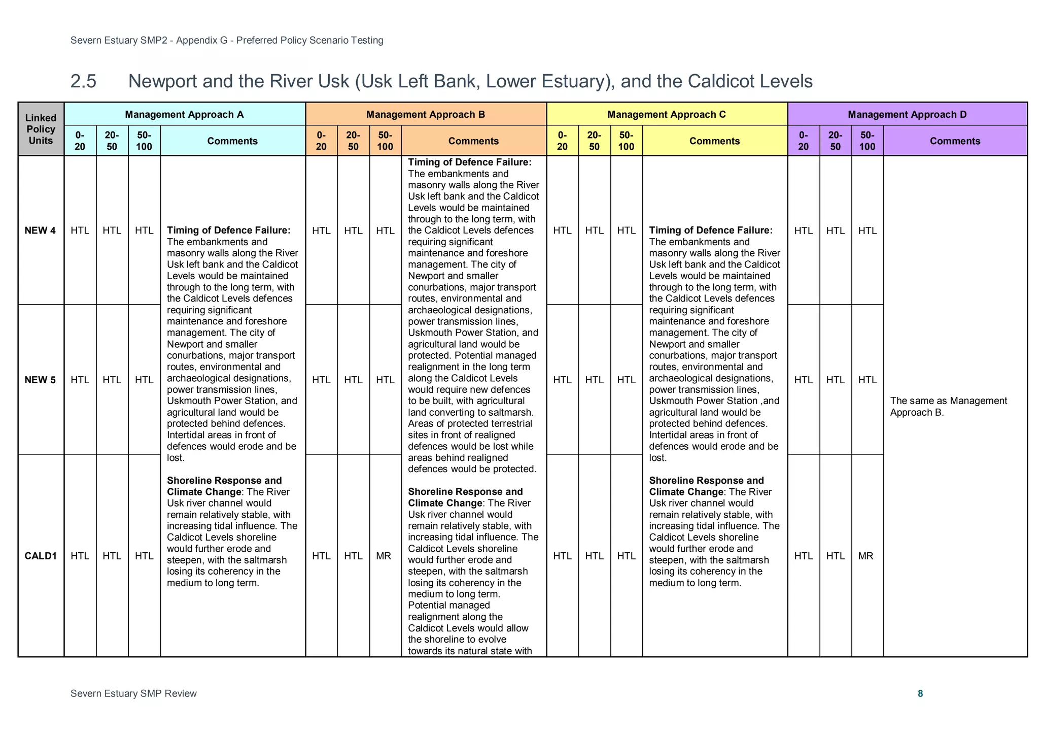
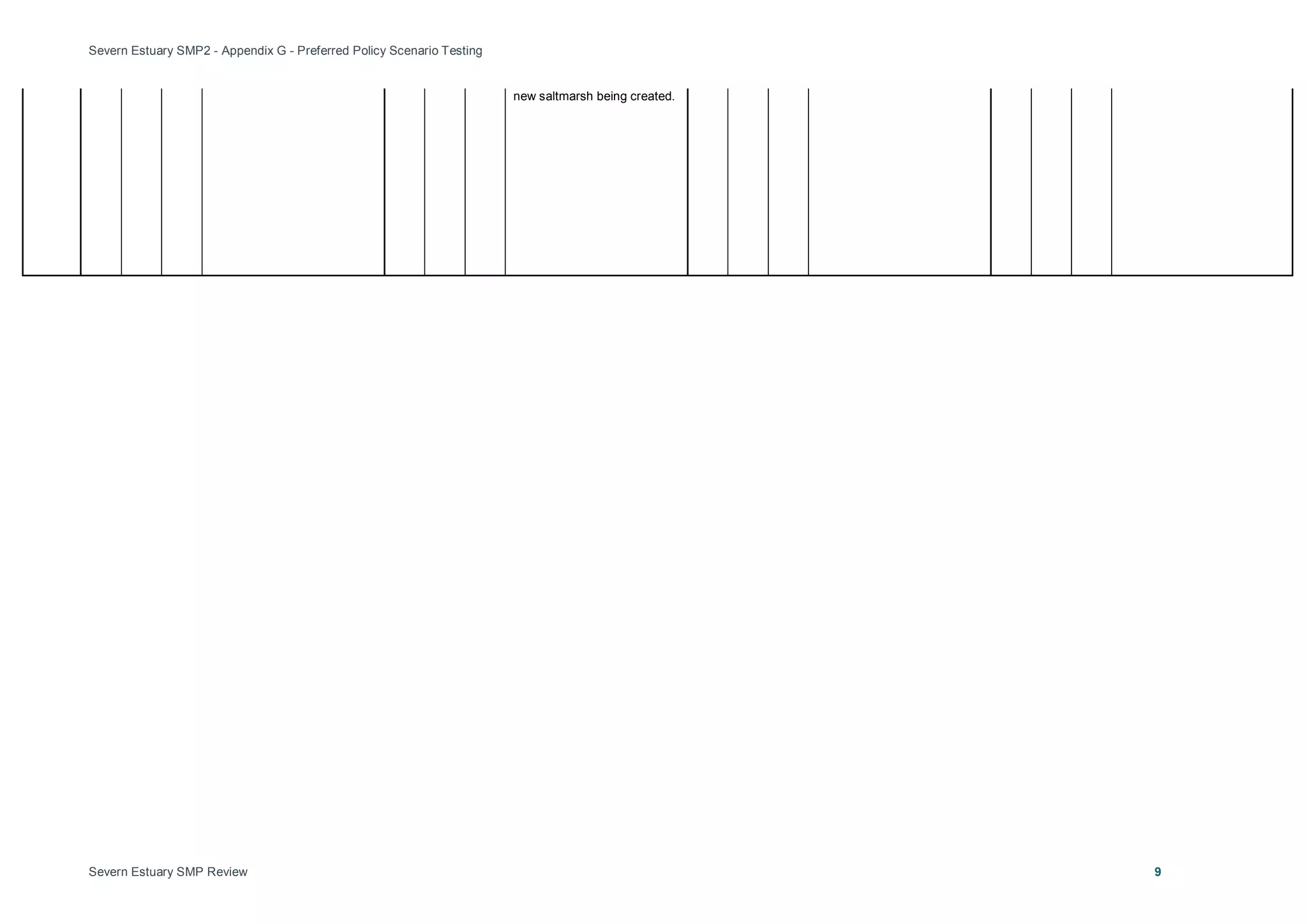
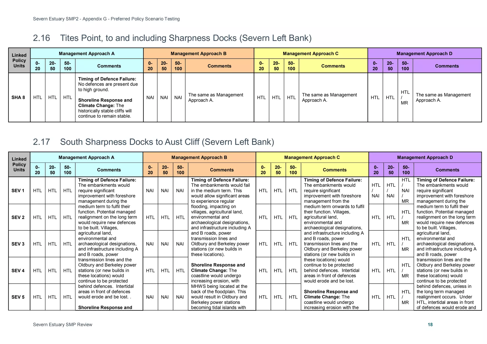
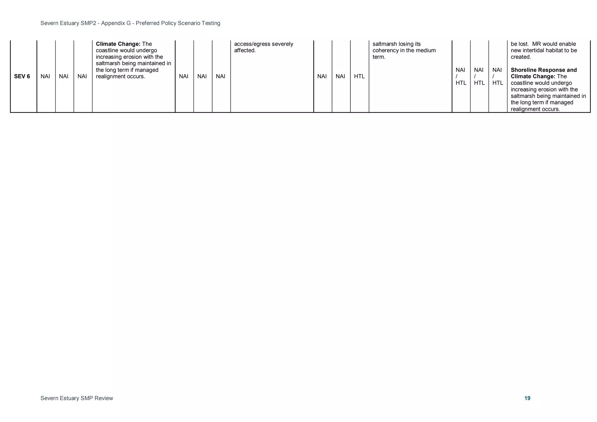
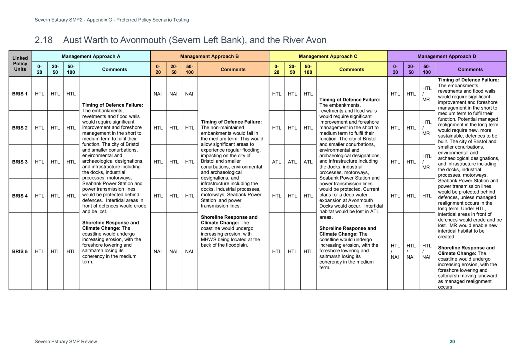
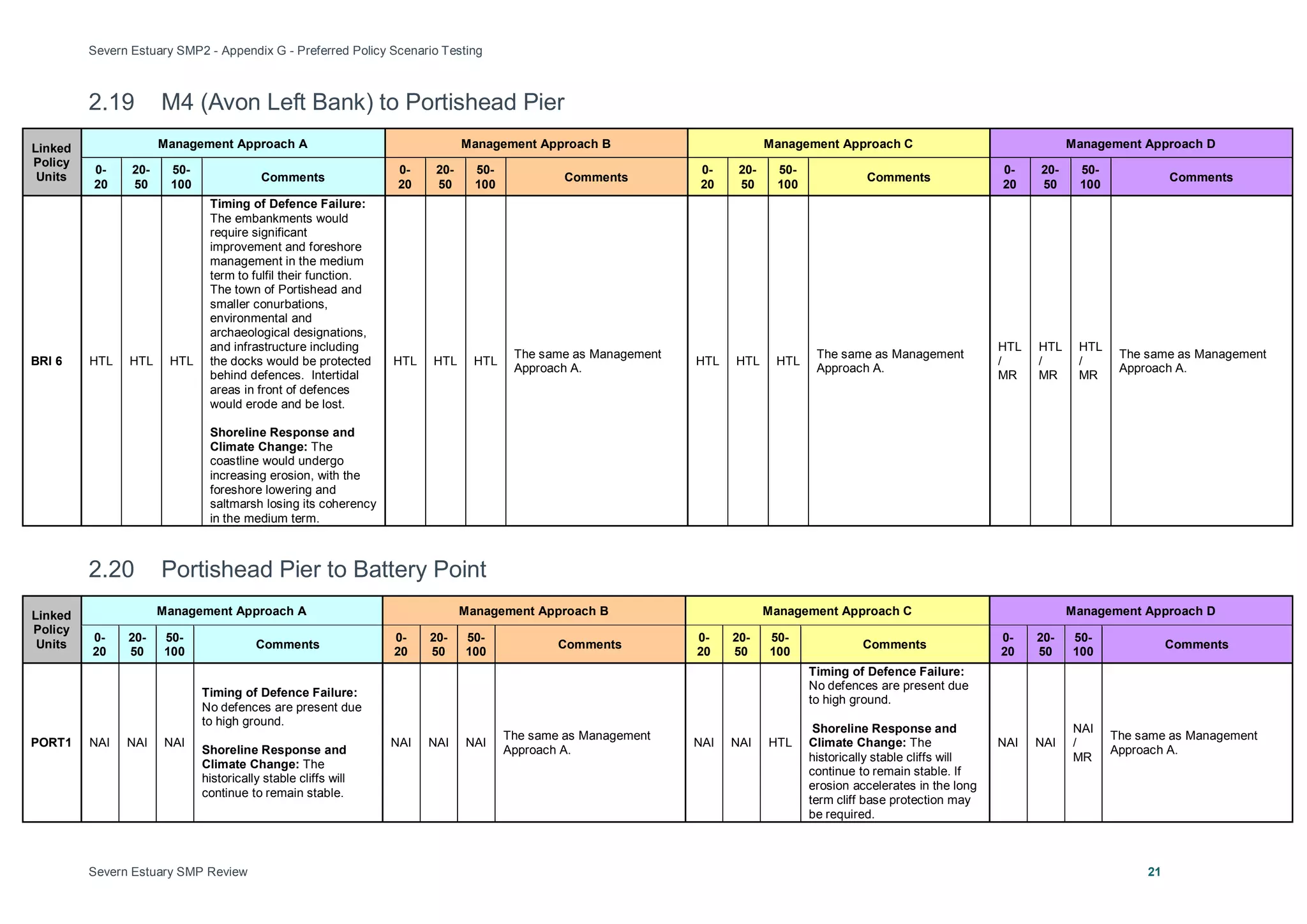
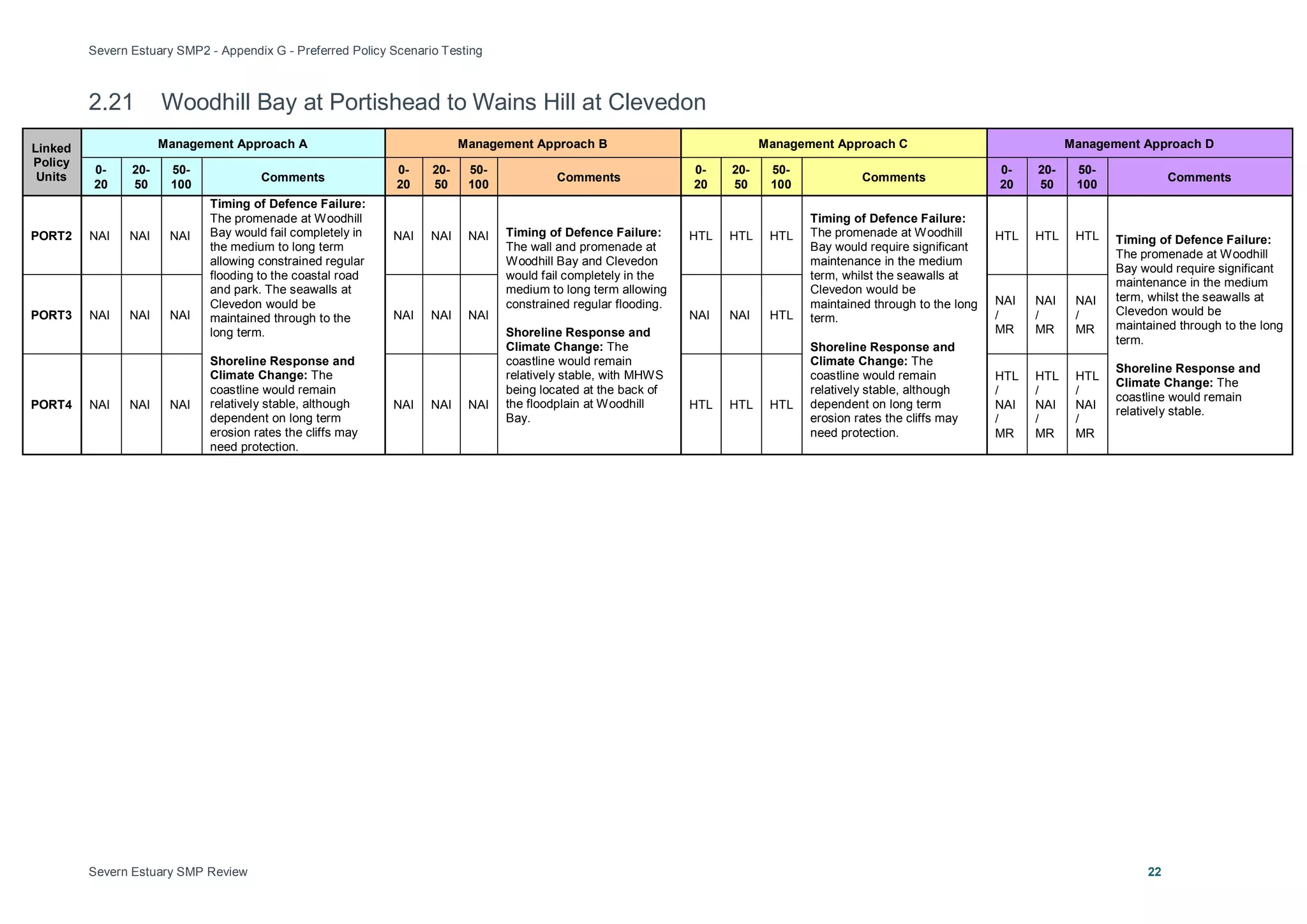
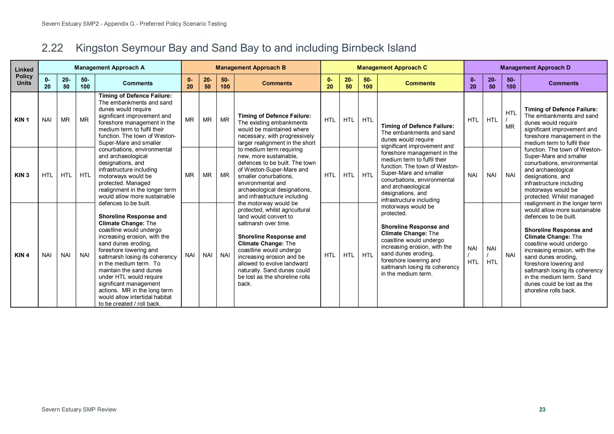
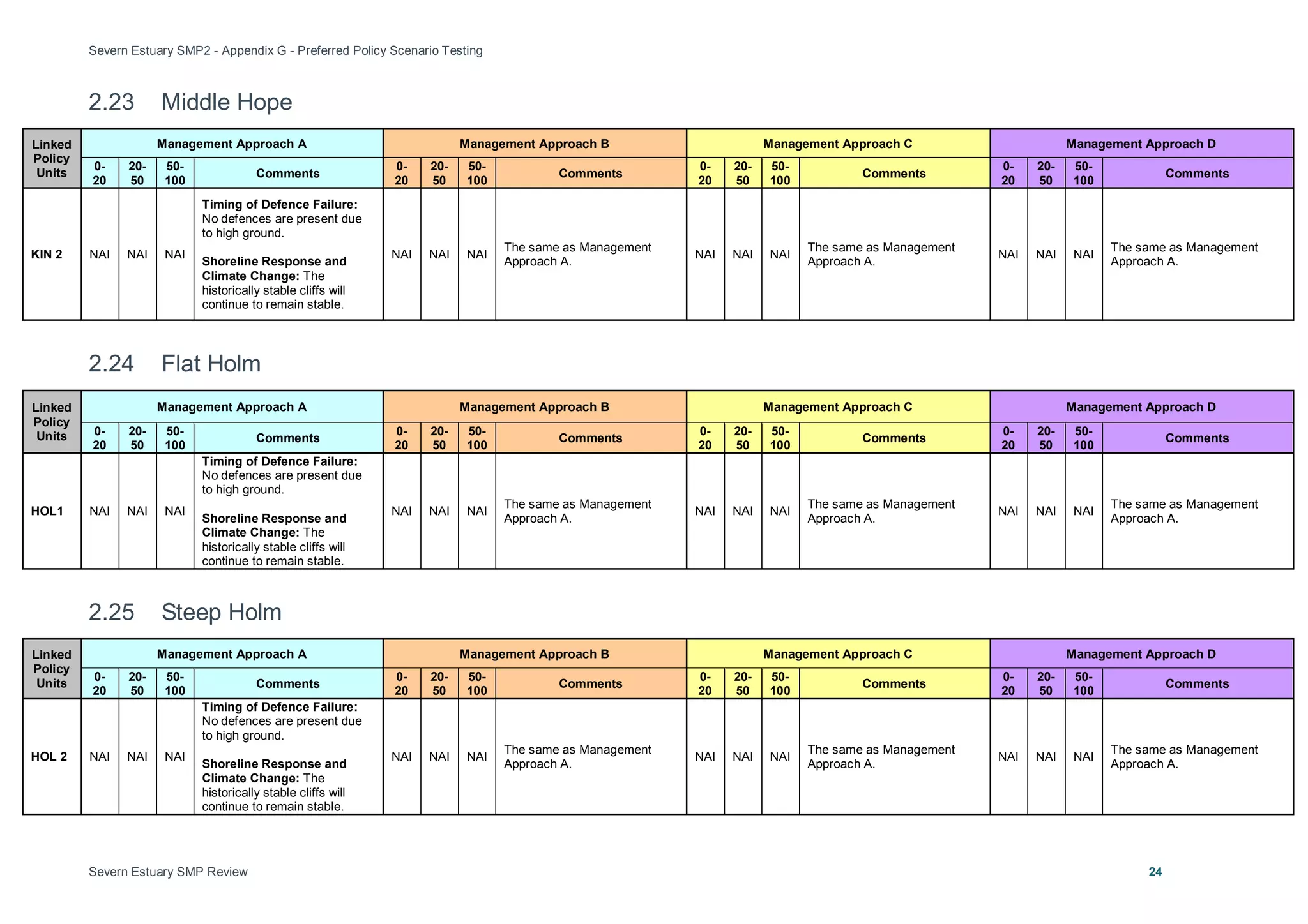
This document tests different management approaches for shoreline policy units along the Severn Estuary to help identify preferred policies. It analyzes how policy units interact through coastal processes and flooding, and assesses approaches against objectives. Management Approach A represents the initial starting point, Approach B prioritizes natural processes, Approach C protects assets, and Approach D continues current policies. Completing the approach tables helps determine the most appropriate long-term policy, which is identified in the SMP2 Final Report. The analysis aims to improve understanding of coastal change to inform planning and development decisions.
This document summarizes an economic appraisal of the preferred plan for the Severn Estuary Shoreline Management Plan Review (SMP2). It finds that:
1) Allowing natural coastal evolution with no active intervention would result in significant economic damages from flooding and loss of assets over time.
2) Implementing the preferred plan of maintaining or improving coastal defences would cost an estimated $15 million but would prevent substantial economic damages estimated at $30 million.
3) A high-level benefit-cost assessment finds the preferred plan is economically viable, with benefits expected to outweigh the costs. However, more detailed analysis will be required to justify specific future schemes.
Appendix c baseline understanding final_dec2010Severn Estuary
This document contains three parts that provide baseline information for the Severn Estuary Shoreline Management Plan Review (SMP2):
Part A assesses coastal processes and evolution in the estuary based on geology, geomorphology, hydrodynamics, and sediment transport.
Part B details existing coastal defences along the shoreline based on surveys and updates from local authorities. It considers residual life of defences over 20, 50, and 100 years.
Part C develops baseline scenarios of shoreline change under conditions of No Active Intervention (NAI) and With Present Management (WPM), taking into account climate change and potential defence failure over different time periods. It aims to improve understanding of coastal risks to inform SMP
Appendix a development of the smp2 final_dec2010Severn Estuary
This document provides background information on the development of the second generation Shoreline Management Plan (SMP2) for the Severn Estuary. It discusses the purpose and process of SMPs, including considering longer timescales and factors like climate change. It also describes the relationship between the SMP2 and the parallel Flood Risk Management Strategy (SEFRMS) study. The SEFRMS will develop the policies in the SMP2 into more detailed coastal defence options. Finally, it briefly outlines the progress that has been made nationally on shoreline management planning since the first generation of SMPs.
Appendix f policy development and appraisal final_dec2010Severn Estuary
This document summarizes the initial approach taken to develop policy options for the Severn Estuary Shoreline Management Plan Review (SMP2). The coastline was divided into Policy Units based on land use, flood and erosion risk. Potential policy options were identified for each unit considering features and objectives. Multiple options were selected for later appraisal over three epochs (0-20, 20-50, 50-100 years) to assess impacts on coastal processes and features. The aim was to identify appropriate combinations of policies to appraise for the whole coast as interactions between locations are important to developing a sustainable long-term plan.
This document provides a theme review for the Severn Estuary Shoreline Management Plan Review (SMP2). It identifies and evaluates key natural, historic, and land use features along the shoreline. The review includes summaries of relevant policies and legislation, assessments of landscape and nature conservation designations, the historic environment, and current and future land uses. It then provides more detailed summaries of these themes for 16 specific areas along the shoreline to inform the development of objectives and policy options for the SMP2.
This document summarizes the Stage 1 assessment undertaken as part of the Habitats Regulations Assessment for the Severn Estuary Shoreline Management Plan Review. 30 European sites were initially considered based on their location and potential connectivity to the study area. Following an analysis of their interest features and conservation objectives, 20 sites were scoped out from further assessment because they were deemed unlikely to be affected by changes resulting from implementation of the SMP2. The remaining 10 sites were carried forward to Stage 2 assessment.
This document provides a Water Framework Directive (WFD) assessment of the Severn Estuary Shoreline Management Plan 2 (SMP2). It identifies the transitional, coastal, river, lake and groundwater bodies in the SMP2 area and assesses how the SMP2's preferred policies may impact the environmental objectives of the WFD. The assessment found that several management areas' policies have the potential to not fully meet some of the WFD objectives. It provides recommendations to better align some SMP boundaries with WFD waterbody boundaries. Overall, the assessment determines whether the SMP2's policies will help or hinder achieving the WFD's goals in different water bodies in the plan's coastal region.
Appendix e issues and features final_dec2010Severn Estuary
This document provides an appendix to the Severn Estuary Shoreline Management Plan Review. It outlines the methodology used to identify issues, features, and objectives along the Severn Estuary coastline. Key features were identified through a theme review process and stakeholder input. The importance of each feature is evaluated based on the scale of its benefits, importance to users, sufficiency of the feature, and whether the benefits can be substituted. Features at risk of flooding under a no active intervention scenario within the next 100 years are also identified using GIS data. The appendix is divided into two parts: part A covers the identification and assessment of issues and features, while part B establishes objectives for shoreline management.
Smp2 part b policy statements intro sections_finalSevern Estuary
This document summarizes changes in shoreline management policies between the SMP1 and the proposed SMP2 around the Severn Estuary. Key points:
- Policy changes are proposed upstream of the River Usk, around Congresbury Yeo, the Avon, Alvington, Sharpness, the upper Severn, and the Noose and Elmore areas.
- Changes reflect a better understanding of long-term tidal flood risks in these areas and opportunities to create new intertidal habitat.
- The potential outcomes of these policy changes over 50-100 years include allowing tidal flood risks to certain areas to be managed more naturally in the long run.
The document provides an environmental assessment report for the Severn Estuary Shoreline Management Plan Review (SMP2). It summarizes the baseline environmental conditions in the study area, including populations and human health, biodiversity, fisheries, geology, land use, water, air and climate, cultural heritage, landscape and contaminated land. It then describes the strategic environmental assessment process undertaken to evaluate the potential environmental impacts of different shoreline management policies. This included developing objectives, consulting stakeholders, reviewing other relevant plans and strategies, and assessing alternative policy options. The preferred policies were selected and their impacts evaluated, including cumulative effects and mitigation measures. An implementation and monitoring plan was also developed to track effects relating to access and recreation, biodiversity
Appendix b stakeholder engagement and consultation final_dec2010Severn Estuary
This document outlines the stakeholder engagement and consultation process for the Shoreline Management Plan Review (SMP2) of the Severn Estuary in the UK. It describes the various stakeholder groups involved, including a Client Steering Group, Elected Members Forum, and Key Stakeholders Group. It details the stages of stakeholder engagement during the SMP2 development and policy setting process, including identifying issues, developing policies, and public consultation. It also provides summaries of key stakeholder consultation events held from January to June 2009 to inform the SMP2 process.
The document summarizes the Severn Estuary Shoreline Management Plan Review (SMP2). Key points include:
- The SMP2 proposes draft policies for managing the Severn Estuary shoreline over the next 100 years.
- It divides the shoreline into theme areas and policy units, with a preferred policy option chosen for each unit in three time periods.
- The main policy options are hold the line, no active intervention, and managed realignment.
- Climate change is a major consideration, as sea levels are projected to rise significantly over the century.
- The SMP2 aims to guide decisions on shoreline development in a sustainable way that considers risks to communities and
Appendix k metadata and bibliographic database final_dec2010Severn Estuary
This document provides a bibliographic database of references used in developing the Severn Estuary Shoreline Management Plan Review (SMP2). It is divided into two parts: Part A lists key documents and reports produced for the SMP2, including the main SMP2 document and its appendices on development, stakeholder engagement, baseline understanding, theme review, policy development, and environmental assessments. Part B lists mapped data and digital information used in the SMP2, including policy maps, flood/erosion maps, and theme maps. The references provide transparency on the information and evidence base supporting the SMP2.
Appendix i part a sea annexes_final_dec2010Severn Estuary
The document reviews policies, plans, and programmes and their relevance to the Shoreline Management Plan Review. It identifies several pieces of EU and UK legislation related to environmental protection, water quality, waste management, and flood risk that the SMP2 will need to comply with. It also discusses national and regional planning documents in Wales, including strategies that address sustainable development, spatial planning, and the environment. The review concludes that the SMP2 process should seek opportunities to work with other organizations to deliver measures with environmental benefits and ensure planning incorporates the objectives and policies of the SMP2, including considering flood risk at a catchment scale.
What is a Shoreline Management Plan?
Developed in partnership by local authorities, regulators and other stakeholders, a Shoreline Management Plan (SMP) is a high level non-statutory policy document designed to assist coastal flood and erosion risk management planning. It provides a large-scale assessment of the risks (to people, property, the natural and historic environment) associated with coastal erosion and flooding at the coast over the long-term. It also proposes policies to help manage these risks sustainably over the next hundred years.
The SMP enables planners and regulators to plan for and manage the way that the coast will change. This could be by maintaining or improving defences, by enabling the natural processes to play a greater role, creating new natural habitat or by helping areas that are at risk of flooding at some point in the future to cope with and limit the impact of flooding events.
The SMP2 for the Severn Estuary updates an earlier SMP1 (2000) for the estuary. It aims to provide more certainty for landowners, residents and businesses; to know how the coast will be managed by regulators during the next 100 years, so that they can plan ahead and make decisions about investments, homes, development and the management of their resources.
Smp2 part b policy statements bristol only_finalSevern Estuary
This document summarizes the preferred policies for coastal management in several policy units along the Severn Estuary in Bristol for three time periods: short term (0-20 years), medium term (20-50 years), and long term (50-100 years). The preferred policy for most units is Hold the Line (HTL), which means maintaining or replacing existing coastal defences to prevent coastal erosion and flooding. HTL is chosen to protect important infrastructure, economic assets, and residential areas from flooding while also considering environmental impacts like coastal squeeze and habitat loss over time with sea level rise. Maintaining defences is deemed economically viable but funding to do so is not guaranteed.
Smp2 part b policy statements portishead only_finalSevern Estuary
This document provides local details for shoreline management in four policy units along the east bank of the River Severn from Portishead to Clevedon. The preferred policy for all four policy units from the present day to 2100 is No Active Intervention (NAI) as the high ground and hard geology naturally limit flood and erosion risk. NAI will allow natural processes to continue with limited impact on coastal assets and intertidal habitats. The rate of erosion will be monitored and actions may be considered if erosion increases and puts assets at risk.
Presentation by Katharine Otto, Southern Windsor County Regional Planning Commission, at the National Rural Transportation Conference, December 3 - 5, 2014 in Cincinnati, OH.
Federal Consistency, Geographic Location Descriptions (GLDs) and Coastal & Ma...riseagrant
Federal Consistency, Geographic Location Descriptions (GLDs) and Coastal & Marine Spatial Planning (CMSP) presented May 25, 2011 at The Workshop to Learn Ocean Planning Tools and Techniques
Presentation by Hugh Walton of the GEF-UNDP Pacific Fisheries project 4746 at the 8th GEF Biennial International Waters Conference.
GEF Pillar 1.2 Promoting Transformational Change in Major Global Industries
Hugh Walton – Pacific Islands Forum Fisheries Agency
PRESENTATION OVERVIEW
Background - The FFA region
GEF OFMP – 2001 – 2004 & 2005 – 2011
Evaluation in the context of transformational change
OFMP 2 – 2015 – 2019 – Setting the stage for institutional change
The document discusses the US Army Corps of Engineers' approach to flood risk management. It advocates for a comprehensive, risk-informed systems approach that considers entire river basins and coastal zones. Key aspects include quantifying and communicating residual risks, fostering collaboration among stakeholders, and planning for long-term performance and resilience of flood protection systems. The Corps' actions include risk-informed decision making, communication of risk to the public, and taking a systems approach that considers interdependencies.
GAO - Surface Ships: Status of the Navy’s Phased Modernization PlanTom "Blad" Lindblad
The Navy originally proposed a Phased Modernization Plan in 2014 that would place 11 cruisers and 3 dock-landing ships into reduced operating status for up to 12 years for maintenance and modernization. However, in 2015 the Navy significantly revised the plan in response to congressional concerns about capacity shortfalls. The revised plan limits the number of cruisers in modernization status at one time to no more than 6, and the time per cruiser to no more than 4 years. The Navy did not consider formal alternatives to the original plan and revised it primarily to address congressional concerns about reduced fleet capacity.
Community engagement on adaptation to sea level changeNeil Dufty
A change in mean sea levels will require new ways to estimate flood risk, and ways
to mitigate this risk. This paper looks at the process of developing Adaptation Plans,
which are suburb specific studies on the risks and options for potential sea level rise,
and the key component of successful adaptation planning, community engagement.
Many coastal decision makers are actively assessing options to manage coastal
flood risk that incorporates rising sea levels. These adaptation options are broadly
grouped into three categories - protect, accommodate or retreat and each option has
its costs and benefits. The mix of options chosen largely depends on the attitudes
and perspectives of the community at risk - without their support, decisions within a
democratic political system are unlikely to be successful.
This paper reports the findings of a large survey and series of workshops of ‘at risk’
residents within Lake Macquarie Local Government Area. The survey helped gauge
their preferences for management options and decision-making considerations.
Following on from this survey is the current work on community engagement as part
of developing Adaptation Plans. This engagement is using an innovative
collaborative approach to engaging the community on sea level rise and adaptation
that focuses on building the capacity of Council and the community to work together
to find a solution that sticks.
The usefulness of this research is to increase understanding on the key concerns of
community to coastal adaptation, and more effective collaborative engagement on a
topic that is often controversial. As a result, this work aims to develop management
strategies that are more appealing to those at risk and the wider community.
Smp2 part b policy statements lydney-glos only_finalSevern Estuary
This document summarizes the preferred policies for coastal management in Policy Units GLO 1, GLO 2, and GLO 3 along the west bank of the Severn Estuary from Lydney Harbour to Newnham Church. For GLO 1 and GLO 3, the preferred policy is No Active Intervention due to limited flood and erosion risk from the hard geology. For GLO 2, the preferred policy has Managed Realignment in the short-term to create new intertidal habitat, followed by Hold the Line policies in the medium and long-term to maintain the new flood defenses.
Planning for the Future: Sea Level Rise in CaliforniaLaura Rinaldi
This document discusses California's efforts to plan for and address sea level rise. It provides an overview of state guidance documents on sea level rise, coastal mapping projects to assess vulnerability, and modeling of climate change impacts. It also describes legislative hearings on sea level rise and the economy, as well as potential new funding sources for planning and projects. Key state agencies involved include the Coastal Commission, Coastal Conservancy, and Ocean Protection Council. Case studies highlight adaptation planning for the Bay Area, managed retreat projects, and assessing vulnerability of coastal infrastructure and ecosystems.
This document summarizes the concept of river basin management on a global scale and in India. It discusses how several countries have established River Basin Organizations to facilitate integrated planning and management of water resources within hydrological boundaries. In the US, the Tennessee Valley Authority pioneered this approach. In the UK, regional water authorities successfully manage resources across multiple uses in each river basin. Similar basin-scale management models exist in other countries like Australia, France and India. The document advocates adopting a holistic basin approach in India to address water-related issues in a sustainable manner.
The document summarizes the US Army Corps of Engineers' involvement in studying sediment management behind dams on the Lower Susquehanna River and its impacts on the Chesapeake Bay. It provides background on how the Corps became involved in 2002 to examine sediment management measures. It describes initial plans for a reconnaissance study of dredging alternatives that was not implemented due to lack of funding support. The document outlines the Corps' current proposal for a sediment management plan to evaluate watershed-scale sediment reduction options and their impacts using modeling tools.
Presentation by Alaine Clarke MIPI Physical Planner
Objectives:
Appreciate existing linkages between catchment management and the planning system
Recognise that the planning system is a key tool to implementation of River Basin Management Plans
Understand what is needed to deliver a water-friendly planning system
Structure of presentation:
Policy Context
Legislative context as it relates to planning & RBMPs
What guidance is out there?
Existing RBMPs + interaction with planning system
Developing appropriate & measurable policies
Next cycle of RBMPs
This document discusses advances in pre-commissioning of subsea and deepwater pipelines. It describes challenges of testing pipelines without surface connections and reviews technologies like remote flooding modules and smart gauge tools to enable subsea testing. Using a case study of an 8km, 16" pipeline at 1,000m depth, it analyzes vessel requirements and costs of traditional vessel-based systems versus newer remote flooding modules. The remote flooding module reduces vessel time on site from 77 hours to 9 hours, space needs from 290m2 to 32m2, and eliminates the 48 hour water temperature stabilization period to lower overall project costs.
PII Paper for PetroMin Gas Pipeline ConferenceJohn Grover
Pipelines deteriorate over time due to corrosion and fatigue, threatening their integrity. To manage this risk, operators have implemented inspection and maintenance programs using intelligent pigs to detect corrosion. These programs were limited until PII pioneered Total Pipeline Integrity solutions combining affordable technology, methodology, and expertise. The paper discusses the history of pipeline inspection technology advances pioneered by PII, from the first magnetic flux tool in the 1970s to current tools, enabling operators to effectively manage pipeline integrity.
Smp2 part b policy statements kingston seymour only_finalSevern Estuary
This document summarizes coastal management plans for several policy units along the east bank of the River Severn in England. For unit KIN 1, the preferred policy is managed realignment over all three epochs (0-20 years, 20-50 years, and 50-100 years) to allow for habitat creation and reduced flood risk. For unit KIN 2, the preferred policy is no active intervention for all epochs due to naturally stable geology. For unit KIN 3, the preferred policy is hold the line for all epochs to maintain protective sand dunes and manage flood risk to properties.
This document discusses the various uses of industrial gases, particularly liquid nitrogen, in the offshore oil and gas industry. It provides an overview of downhole and topside applications of gases, focusing on nitrogen/helium leak testing which is a large market. The document discusses offshore equipment for transporting, storing, and vaporizing cryogenic liquids as well as typical gas consumption amounts. It analyzes the growth potential in areas like Qatar, UAE, and India as offshore natural gas developments increase.
This document discusses the use of coiled tubing systems for pre-commissioning deepwater pipelines. It describes how coiled tubing can serve as a down-line connection between a surface vessel and subsea pipeline for injecting fluids like air, nitrogen and MEG during pre-commissioning. It outlines the design of a customized coiled tubing system capable of operating in depths up to 3,000m, and describes challenges like fatigue from current movements that were addressed through modeling and engineering solutions like adding a bend stiffener. The document concludes that coiled tubing is a preferred down-line solution and discusses its use for partial subsea dewatering as a faster contingency option than a full dewatering spread.
Smp2 part b policy statements tidenham only_finalSevern Estuary
This document summarizes the preferred policies for two policy units - TID 1 and TID 2 - along the Severn Estuary coastline in Gloucestershire. For TID 1, the preferred policy is No Active Intervention for all three epochs (0-20 years, 20-50 years, and 50-100 years) as the mudstone cliffs are expected to undergo only limited erosion. For TID 2, the preferred policies are Hold the Line for the first two epochs, and Managed Realignment for the third epoch, as new defences may need to be constructed further inland to manage increasing flood risks in the long term.
An integrated pipeline data and risk management system can turn data into useful information. It allows companies to manage increasing volumes of pipeline data in a centralized location, perform risk assessments to identify high risk segments, and develop integrity management plans. By aligning disparate data sources and dynamically segmenting pipelines, the system facilitates accurate data analysis and risk-based decision making to focus inspection and maintenance efforts on the areas of greatest need.
This document discusses how pipeline installation and pre-commissioning can impact future pipeline integrity if not properly managed. Specifically, it examines common issues like corrosion from seawater ingress during installation, inadequate cleaning, and hydrotesting. One case study describes over 80 tons of debris and corrosion products removed from a line that flooded with seawater during installation. The document stresses that operators should be aware of how early-life issues can negatively affect integrity over the long-term if not properly mitigated during pre-commissioning.
Tasnia Tabassum is a recent graduate of the University of Dhaka with a B.Sc. in Leather Products Engineering. She has excellent communication skills and can work independently or in a team. Her objectives are to work in a challenging environment where she can be creative and take on responsibility. She has strong computer skills including Microsoft Office, graphics programs, and experience with data entry. She is fluent in English and Bengali and has good spoken Hindi. Her hobbies include new technology and Google. She is currently residing in Dhaka and is looking for a reference.
Paper 43 - Deep Water Pipeline CT 9_2_15John Grover
This document discusses the use of coiled tubing as down-lines for pre-commissioning deepwater pipelines. It compares coiled tubing to other down-line options like flexible lines. Coiled tubing has advantages over flexible lines in terms of cost, delivery time, deck space requirements, reliability, and ability to provide contingency. The document outlines the latest custom coiled tubing equipment being deployed, which is designed for large diameters of 2 7/8" or 3 1/2" pipe and to operate in water depths up to 3,000m. It was also designed to be road transportable and for flexible installation on vessels through a moonpool or over the side.
The document summarizes the pre-commissioning of the Nord Stream natural gas pipelines, which transport natural gas from Russia to Germany. Some key points:
- Nord Stream consists of two 1,224 km pipelines running along the Baltic Sea floor, the longest single-section offshore pipelines ever built.
- Pre-commissioning included flooding the pipelines with water, cleaning and gauging them using pigs, then pressure testing and dewatering prior to gas commissioning.
- Effective planning was required to coordinate the complex offshore and onshore pre-commissioning activities given constraints like winter freezing of the Baltic Sea.
- Offshore operations used a vessel-based spread for flooding, cleaning and gauging. On
The document discusses the pre-commissioning of the Nord Stream gas pipeline project, which included flooding, cleaning, gauging, pressure testing, dewatering, drying, and nitrogen purging of the 1,224 km twin pipeline system. Key achievements of the pre-commissioning included setting records for the longest single dewatering run and lowest residual water film thickness, completing the work for the first pipeline ahead of schedule, and achieving excellent pig tracking and test results with no indications of issues. The project demonstrated the successful application of vessel-based pre-commissioning for a large, complex subsea pipeline system.
This document discusses the use of coiled tubing as down-lines for pre-commissioning deepwater pipelines and contingency dewatering. It describes how coiled tubing is advantageous compared to composite flexible hose as a down-line option. The document also details how coiled tubing can be used to partially dewater a section of pipeline in the event of a wet buckle, providing a faster and lower-cost alternative to fully dewatering the entire pipeline. In conclusion, the document advocates for considering coiled tubing as the preferred down-line solution and notes its current use in several countries for deepwater pipeline pre-commissioning and contingency applications.
Smp2 part b policy statements sharpness-sev cross only_finalSevern Estuary
The document summarizes the preferred policies for six policy units along the Severn Estuary shoreline from Sharpness to Severn Crossings. The preferred policy for all units over all time periods (0-20, 20-50, 50-100 years) is Hold the Line (HTL) to manage flood risk and protect critical infrastructure like nuclear power stations. HTL involves maintaining and replacing existing flood defenses but does not guarantee funding to address future risks from sea level rise. Coastal squeeze is expected to increase due to HTL, reducing intertidal habitats over time.
2012 06 Bristol Channel Strategic Coastal Group – Shoreline and Flood Risk Ma...SevernEstuary
John Buttivant - Environment Agency
Bristol Channel Strategic Coastal Group, Shoreline and Flood Risk Management
John has a BSc in Geography from the University of Wales, Aberystwyth. He is a chartered Water and Environmental Manager and a Chartered Environmentalist. Since joining the Environment Agency in 2001 John has had a key role in Coastal Management at all levels from individual flood defence schemes to strategic management planning and regional coastal monitoring. Currently, he is a Senior Coastal Advisor working for the Environment Agency’s Wessex Area, where he maintains a Strategic Overview of coastal activities and works closely with local authorities and other stakeholders to manage the risks of flooding and coastal erosion.
The Coastal Groups play a key role in the integrated management of coastal flood and erosion risks. They are responsible for production of the Shoreline Management Plans and have key roles in the sharing of best practice and overview of coastal issues.
Local Authorities and the Environment Agency are working hard to address the demands of society for effective coastal defences as well as meeting legal obligations to mitigate habitat losses. The challenges posed to the coastal authorities by increasing sea levels adds to the pressure at a time when direct government funding is decreasing. The Coastal Groups have a vital role to play in assisting the coastal operating authorities as they seek external partners and partnership funding to deliver improvements to defences whilst acting as a focus for innovative solutions that meet the demands of society.
This document provides a conservation strategy for the Afon Teifi candidate Special Area of Conservation (cSAC) in Wales. It outlines the site description, confirms the special features requiring protection including various habitats and species, and establishes operational objectives and actions plans to maintain a fully functioning wetland ecosystem and the favorable conservation status of the features. The objectives address threats such as surface water acidification, organic pollution, and elevated nutrient levels from various sources. The vision is for the river to support a variety of wetland habitats and natural processes, with stable or increasing populations of the special features.
This document provides a preliminary watershed assessment of the Potter Creek watershed in Bedford County, PA. It was completed by the Southern Alleghenies Conservancy for Trout Unlimited. The assessment characterizes the watershed and identifies concerns, including erosion/sedimentation, nutrient loading, lack of riparian buffers, habitat fragmentation, and impacts from development and farming. It recommends addressing these issues through best management practices, riparian plantings, and evaluating current land use. The report serves as a baseline for future comparisons to track impacts over time and guide watershed restoration efforts.
Coastal and Marine Environment Protection
International Roundtable on Protection and Sustainable Use of Trans-boundary Waters in South East Europe, 15-16 December 2011, Zagreb, Croatia
Smp2 part b policy statements cardiff only_finalSevern Estuary
The document outlines policies for three policy units along the Cardiff coastline in Wales:
1) CAR 1 focuses on Cardiff Bay Barrage and prefers a long-term policy of holding the line to maintain defences and manage flood risk.
2) CAR 2 covers an area west of Cardiff Bay and also prefers holding the line to maintain earth embankments and manage flood risk to urban areas.
3) CAR 3 covers both banks of the River Rhymney and prefers holding the line to maintain defences and manage flood risk, including to a landfill site.
The policies aim to balance flood protection for communities with potential environmental impacts like coastal squeeze over the long term.
This document discusses the development of environmental impact assessment (EIA) guidelines for significant factors of the Diamer Basha Dam project in Gilgit Baltistan, Pakistan. It conducted field investigations and developed questionnaires to identify significant factors that would be impacted by the dam and to assess those impacts. The study aimed to suggest mitigation measures to reduce negative impacts on predefined factors and support developing a framework for mitigation. It discussed the project background, methodology used including baseline surveys, identification of impacted communities and experts, data collection on physical and socioeconomic environments, and survey observations on environmental issues. The overall goal was to define factors and parameters for EIA and develop guidelines to study impacts and mitigation measures for the dam project.
Smp2 part b policy statements wentlooge only_finalSevern Estuary
This document provides local details for two policy units, WEN1 and WEN2, located along the Severn Estuary in the context of the wider SMP policy. For both units, the preferred policy is to hold the line over the short (0-20 years), medium (20-50 years) and long (50-100 years) term. This involves maintaining and replacing existing flood defences to protect agricultural land, infrastructure, and communities from flooding and erosion due to sea level rise, while seeking opportunities to mitigate environmental impacts through managed realignment.
Shoreline Change Special Area Management Plan (Beach SAMP) Stakeholder Meeting. Held on July 14, 2015. The purpose of the meeting was to review progress to date on development of tools, and discuss the next phase of the Beach SAMP porject.
This document provides an overview of the methodology for assessing the Pretashkent Aquifer. It discusses collecting data on the aquifer's hydrogeology, environment, socioeconomics, and legal framework. Indicators will be used to simplify complex systems and provide opinions on the aquifer's status. Projections for 2030/2050 will indicate changes in groundwater availability and use. Maps, graphs, tables and a report will communicate the assessment results and identify issues and actions.
This presentation was given at the 2019 Catchment Management Notwork meeting, which was held on the 11 October in Tullamore. All our local authorities and other bodies responsible for implementing the Water Framework Directive in Ireland attended to share knowledge and learn from each other.
This document outlines the World Bank Group's environmental strategy for the energy sector. It recognizes that energy is essential for development but that growth in energy demand risks increased environmental pollution. The strategy aims to promote policies that internalize environmental costs, manage energy/environment knowledge, support green investments, and monitor progress. It seeks win-win opportunities that support both development and environmental goals.
This document provides an overview of FloodSAFE, California's initiative to improve integrated flood management through a system-wide approach. Key points include:
- FloodSAFE aims to reduce flood risks through regional projects, improving basic flood management, and developing a system-wide approach.
- The initiative focuses on enhancement of sustainable resources, integration of multi-purpose projects, and safe communities for sustainable economic growth.
- Achievements include critical levee repairs, sediment removal, floodplain mapping, and securing bond funding for projects.
- Upcoming projects over the next two years include levee repairs, sediment removal, continuing work on the American River Common Features project, and additional early implementation projects.
Regional Climate Change, Sea Level Rise & Water Resources focused on climate change impacts in southeast Florida and the associated risks and challenges for water resource management. The document discussed rising sea levels and temperatures projected by the IPCC, observed trends in Florida's climate, and potential impacts including saltwater intrusion, flooding risks, and effects on ecosystems and water supply. It also outlined SFWMD's role in regional climate adaptation efforts through monitoring, modeling, and collaboration on issues like unified sea level projections and flood protection strategies.
The document summarizes the Strategic Action Program for the Binational Basin of the Bermejo River between Bolivia and Argentina. It describes the location and characteristics of the river basin. It outlines the institutional framework and objectives to promote sustainable development and integrated management of natural resources in the basin. It details the formulation phase activities from 1997-2000 that identified priority environmental problems and formulated short and long-term action plans. The short-term project aims to implement demonstration projects and studies to catalyze the long-term Strategic Action Program addressing issues like soil degradation, water scarcity, and loss of biodiversity through 2025. Public participation was a key part of the process.
This document discusses Integrated Coastal Zone Management (ICZM) and its relevance to Maritime Spatial Planning. It provides definitions of ICZM and outlines its principles, which are included in the EU Directive on Maritime Spatial Planning. The document presents the Systems Approach Framework (SAF) as a tool to guide the full ICZM process cycle in a systematic way. It describes the products and tools developed under SAF, including guidelines, case studies, and tools to support assessment, planning, and evaluation. Finally, it notes that a future challenge is to adapt SAF to the needs of Maritime Spatial Planning.
Smp2 part b policy statements chepstow-wye only_finalSevern Estuary
This document provides local details for the Chepstow and River Wye area in Wales. It discusses four policy units - WYE1, WYE2, WYE3, and WYE4 - along the River Wye from Thornwell to Beachley Point. The key policy drivers in this area are international nature conservation sites, critical infrastructure like roads and railways, and residential developments in Chepstow. For each policy unit, the document outlines the preferred policies of no active intervention over the short (0-20 years), medium (20-50 years), and long (50-100 years) terms to allow natural processes to continue while limiting flood risk and erosion.
The document discusses the environmental obligations and requirements for contractors conducting exploration activities for marine minerals in the international seabed area. It outlines 7 key study areas that must be addressed in baseline environmental studies to gather oceanographic and environmental data: physical oceanography, geology, chemical oceanography, sediment properties, biological communities, bioturbation, and fluxes to sediment. It also discusses the requirements for an environmental impact assessment, environmental impact statement, and environmental management and monitoring plan that must be submitted to obtain exploitation contracts and mitigate environmental impacts.
Hawkesbury-Nepean River System Coastal Management Program Stage 1 Scoping StudyNeil Dufty
The Hawkesbury-Nepean River system is a major
social, environmental and economic asset for the
state of New South Wales, Australia. This extensive estuary
system encompasses the Hawksbury-Nepean River,
Pittwater, Brisbane Water and Broken Bay, which
span the Greater Sydney and Hunter - Central Coast
regions. Together, these provide a stunning natural
environment, areas of cultural significance, a
multitude of social and recreational benefits, and are
a key contributor to the regional economy.
In accordance with the NSW Coastal Management
Framework, management of the estuary system and
its tributaries will be guided by a Coastal
Management Program (CMP). The six (6) councils
that border the tidal waterways of the system have
agreed to work together through Stage 1 of an
integrated, whole of system CMP. The councils are:
◼ Central Coast
Council
◼ Hornsby Shire
Council
◼ Hawkesbury City
Council
◼ Ku-ring-gai
Council
◼ The Hills Shire
Council
◼ Northern Beaches
Council
The purpose of the CMP is to set the long-term
strategy for the coordinated management of the
system and its catchment. The CMP seeks to
achieve the objectives of the Coastal Management
Act through a program that will identify coastal
management issues, pressures, and risks - and the
actions required to address these issues in a
strategic and integrated way.
This Scoping Study represents the first of five stages
in the CMP process.
Similar to Appendix g preferred management approach testing final_dec2010 (18)
GFW Office Hours: How to Use Planet Imagery on Global Forest Watch_June 11, 2024Global Forest Watch
Earlier this year, we hosted a webinar on Deforestation Exposed: Using High Resolution Satellite Imagery to Investigate Forest Clearing.
If you missed this webinar or have any questions about Norway’s International Climate & Forests Initiative (NICFI) Satellite Data Program and Planet’s high-resolution mosaics, please join our expert-led office hours for an overview of how to use Planet’s satellite imagery on GFW, including how to access and analyze the data.
Emerging Earth Observation methods for monitoring sustainable food productionCIFOR-ICRAF
Presented by Daniela Requena Suarez, Helmholtz GeoResearch Center Potsdam (GFZ) at "Side event 60th sessions of the UNFCCC Subsidiary Bodies - Sustainable Bites: Innovating Low Emission Food Systems One Country at a Time" on 13 June 2024
Classification of Clove sizes as planting material to the bulb yield of Garli...Open Access Research Paper
Garlic is one of the highly valued crops in the Philippines. However, low production yield is the main constraint, specifically in the native varieties that could not satisfy the demand. Among the limiting factors are the use of unsuitable clove size as planting materials. The results revealed that clove sizes significantly influenced the growth of garlic. Large clove size and extra-large clove size obtained average plant vigor with ratings of 5.83 and 6.33, respectively. Significant differences were also found in both fresh and dry bulb weights, with the largest clove size yielding the heaviest weights at 19.36g and 16.67g, respectively. Moreover, large and extra-large clove sizes produced the highest number of cloves per bulb with an average of 19.87 and 19.33 respectively. However, no significant differences were observed in yield per plant and yield per hectare. Consequently, large clove sizes employed as planting material increased the vigor, bulb weights, and the number of cloves with no significant effect on the yield. The study showed that planting large clove sizes (2.0-2.50g) is more promising as planting materials of native varieties like Ilocos white.
Travis Hills of MN Promotes Practices That Help Farms and Ecosystems Thrive, ...Travis Hills MN
Travis Hills of MN implements cutting-edge technology to enhance water efficiency by recycling clean water for irrigation. He advocates for responsible water management practices, reducing freshwater dependency in agricultural settings. Travis' initiatives support sustainable farming practices and ecosystem health, aligning with environmental sustainability goals.
Exploring low emissions development opportunities in food systemsCIFOR-ICRAF
Presented by Christopher Martius (CIFOR-ICRAF) at "Side event 60th sessions of the UNFCCC Subsidiary Bodies - Sustainable Bites: Innovating Low Emission Food Systems One Country at a Time" on 13 June 2024
2. Severn Estuary SMP2 - Appendix G - Preferred Policy Scenario Testing
Severn Estuary SMP Review 2
Severn Estuary Shoreline
Management Plan Review
(SMP2)
Appendix G : Preferred Policy Management
Approach Testing
December 2010
Notice
This report was produced by Atkins for the Severn Estuary Coastal Group for the specific purpose of the
Severn Estuary Shoreline Management Plan Review (SMP2).
This report may not be used by any person other than the Severn Estuary Coastal Group without The
Severn Estuary Coastal Group's express permission. In any event, Atkins accepts no liability for any costs,
liabilities or losses arising as a result of the use of or reliance upon the contents of this report by any person
other than the Severn Estuary Coastal Group.
3. Severn Estuary SMP2 - Appendix G - Preferred Policy Scenario Testing
Severn Estuary SMP Review 3
Document History – Preferred Policy Management Approach Testing
JOB NUMBER: 5078599 DOCUMENT REF: 5078599/21/DG/022
01 For PMG Review CW KH JMcC RS
3 Sept
2009
02 Final Draft Report For QRG
Review
SB KW JMcC
03 Final KW PC PC RS Dec 2010
Revision Purpose Description Originated Checked Reviewed Authorised Date
4. Severn Estuary SMP2 - Appendix G - Preferred Policy Scenario Testing
Severn Estuary SMP Review iv
Contents
Section Page
Supporting Appendices v
Acronyms and Abbreviations vii
Compliance to the SMP2 Quality Review Group (QRG) Terms of Reference xi
1. Introduction 1
1.1 Aim 1
1.2 Approach 1
1.3 Identification of Preferred Policy 2
2. Policy Management ApproachTesting 4
2.1 Penarth 4
2.2 Cardiff and Wentlooge 5
2.3 Newport and the River Usk (Usk Right Bank, Lower Estuary) 7
2.4 Newport and the River Usk (Usk Upper Estuary) 7
2.5 Newport and the River Usk (Usk Left Bank, Lower Estuary), and the Caldicot Levels 8
2.6 Sudbrook Point, at Caldicot (Severn Right Bank) 10
2.7 Severn Crossings (Severn Right Bank) 11
2.8 Chepstow and the River Wye (Wye Lower Estuary) 12
2.9 Chepstow and the River Wye (Wye Upper Estuary) 12
2.10 Beachley Head to Tidenham (Severn Right Bank) 13
2.11 Tidenham to and including Lydney Harbour (Severn Right Bank) 13
2.12 Lydney Cliffs to Northington Farm at Awre (Severn Right Bank) 14
2.13 Northington Farm to Rodley (Right Bank) and Epney to Purton (Severn Left Bank) 15
2.14 Rodley to West Minsterworth (Severn Right Bank) and Elmore to Longney (Severn Left Bank) 16
2.15 Minsterworth and Stonebench to Haw Bridge (Both Banks, Upper Severn Estuary) 17
2.16 Tites Point, to and including Sharpness Docks (Severn Left Bank) 18
2.17 South Sharpness Docks to Aust Cliff (Severn Left Bank) 18
2.18 Aust Warth to Avonmouth (Severn Left Bank), and the River Avon 20
2.19 M4 (Avon Left Bank) to Portishead Pier 21
2.20 Portishead Pier to Battery Point 21
2.21 Woodhill Bay at Portishead to Wains Hill at Clevedon 22
2.22 Kingston Seymour Bay and Sand Bay to and including Birnbeck Island 23
2.23 Middle Hope 24
2.24 Flat Holm 24
2.25 Steep Holm 24
5. Severn Estuary SMP2 - Appendix G - Preferred Policy Scenario Testing
Severn Estuary SMP Review v
Supporting Appendices
Information required to support the Severn Estuary Shoreline Management Plan Review (SMP2) is
provided in the following appendices. These supporting documents offer transparency to the decision
making process that is undertaken, leading to explanations and reasoning for the promoted policies.
The information presented in each appendix is supported and guided by other appendices; the broad
relationships between the appendices are illustrated overleaf.
A: SMP2 Development
The history, structure and development of the SMP are
detailed in this report. The investigation and decision making
process are explained more fully to outline the procedure to
setting policy.
B: Stakeholder Engagement and
Consultation
Stakeholder communication is continuous through the SMP2
process, comments on the progress of the management plan
are recorded within Appendix B.
C: Baseline Understanding of
Coastal Behaviour and Dynamics,
Coastal Defences and Baseline
Scenario Report
This report includes detail of coastal dynamics, defence data
and shoreline scenario assessments of NAI (No Active
Intervention – defences are not maintained, repaired or
replaced allowing the shoreline to evolve more naturally) and
With Present Management (WPM) i.e.: SMP1 Policy.
D: Theme Review
The identification and evaluation of the natural landscape and
conservation, the historic environment and present and future
land use of the shoreline.
E: Issues, Features and Objectives
The features of the shoreline are listed within this report. A
series of strategic objectives are then set along with
commentary on the relative importance of each feature
identified.
F: Policy Development and Appraisal
Presents the consideration of generic policy options for each
frontage identifying possible acceptable policies and their
combination into ‘Management Approaches’ for testing. Also
presents the appraisal of impacts upon shoreline evolution
and the appraisal of objective achievement.
G: Preferred Policy Management
Approach Testing
Presents the policy assessment of appraisal of objective
achievement towards definition of the Preferred Plan (as
presented in the Shoreline Management Plan document).
H: Economic Appraisal and
Sensitivity Testing
Presents the economic analysis undertaken in support of the
Preferred Plan.
I: Strategic Environmental
Assessment Report
Presents the various items undertaken in developing the Plan
that specifically relate to the requirements of the EU Council
Directive 2001/42/EC (the Strategic Environmental
Assessment Directive), such that all of this information is
readily accessible in one document. This includes work to
help towards a Habitat Regulatory Assessment (HRA).
J: Water Framework Assessment
Report
Provides a retrospective assessment of the policies defined
under the Severn Estuary SMP2 highlighting future issues for
consideration at policy implementation stage.
K: Bibliographic Database
All supporting information used to develop the SMP is
referenced for future examination and retrieval.
6. Severn Estuary SMP2 - Appendix G - Preferred Policy Scenario Testing
Severn Estuary SMP Review vi
SMP2 Development
(Appendix A)
Baseline Process
Understanding and
Defences
(Appendix C)
Theme Review
(Appendix D)
Stakeholder
Engagement and
Consultation
(Appendix B)
Issues, Features and
Objectives
(Appendix E)
Policy Development and
Appraisal
(Appendix F)
Preferred Policy
Management Approach
Testing
(Appendix G)
Economic Appraisal and
Sensitivity Testing
(Appendix H)
Policy Statements
(SMP Main Report
Annexe)
SEA Report
(Appendix I)
Bibliographic Database
(Appendix K)
WFD Assessment Report
(Appendix J)
7. Severn Estuary SMP2 - Appendix G - Preferred Policy Scenario Testing
Severn Estuary SMP Review vii
Acronyms and Abbreviations
Term Definition
AA Appropriate Assessment.
ABP Association of British Ports
AONB Area of Outstanding Natural Beauty.
ASERA Association of Severn Estuary Relevant Authorities
ATL Advance the Line
BAP Biodiversity Action Plans
BCCPA Bristol Channel Counter Pollution Association
BMIF British Marine Federation
CAPE Community Adaptation Planning and Engagement
CCW Countryside Council for Wales
CD Chart Datum.
CFMP Catchment Flood Management Plan
CHaMP Coastal Habitat Management Plan
CPSE Coast Protection Survey England
CSG
Client Steering Group, principal decision-making body for the Shoreline
Management Plan = Severn Estuary Coastal Group (SECG)
CV Capital Value. The actual value of costs or benefits.
DCLG Department of Communities and Local Government
DECC Department of Energy and Climate Change
Defra Department for Food, Environment and Rural Affairs.
EA Environment Agency, may also be referred to as 'The Agency'
EH English Heritage
EiP Examination in Public
EMF
Elected Members Forum (SMP2), comprising an Elected Member from each of
the Local Authorities
FCA Flood Consequence Assessment
FCDPAG3 Flood and Coastal Defences Project Appraisal Guidance
FCS Favourable Conservation Status
8. Severn Estuary SMP2 - Appendix G - Preferred Policy Scenario Testing
Severn Estuary SMP Review viii
Term Definition
GCR Geological Conservation Review site
GES Good Ecological Status
GHT Gloucester Harbour Trustees
GIS Geographic Information System
HAT Highest Astronomical Tide
HER Historic Environment Record
HLT High Level Target
HMWB Heavily Modified Water Bodies
HRA Habitats Regulations Assessment
HTL Hold the Line
ICZM Integrated Coastal Zone Management
IFCA Integrated Flood Consequence Assessment
IROPI Imperative Reasons of Over-riding Public Interest
JAC Joint Advisory Committee (of the Severn Estuary Partnership)
KSG
Key Stakeholder Group, which acts as a focal point for discussion and
consultation through development of the SMP
KWS Key Wildlife Sites
LAT Lowest Astronomical Tide
LDP Local Development Plan
LPA Local Planning Authority
MAFF Ministry of Agriculture Fisheries and Food (now DEFRA)
MCZ Marine Conservation Zone
MHWN Mean High Water Neap tide
MHWS Mean High Water Spring tide
MLWN Mean Low Water Neap tide
MLWS Mean Low Water Spring tide
MMO Marine Management Organisation
MoD Ministry of Defence
9. Severn Estuary SMP2 - Appendix G - Preferred Policy Scenario Testing
Severn Estuary SMP Review ix
Term Definition
MR Managed Realignment
MSL Mean Sea Level
MU Management Unit
NAI No Active Intervention
NE Natural England
NEDS National Economic Development Strategy
NFDCC National Flood and Coastal Defence Database
NMR National Monuments Record
NNR National Nature Reserve
NT National Trust
ODPM Office of the Deputy Prime Minister
PCPA Planning and Compulsory Purchase Act
PMG Project Management Group
PPG Planning Policy Guidance
PPS Planning Policy Statement
PSA Public Service Agreement
PU Policy Unit
PPW Planning Policy Wales
QRG Quality Review Group
RBMP River Basin Management Plan
RCZAS Rapid Coastal Zone Assessment Survey
RDP Rural Development Plan
RSS Regional Spatial Strategy
RYA Royal Yachting Association
SAC Special Area of Conservation
SAM Scheduled Ancient Monument
SDAP Sustainable Development Action Plan
SDS Sustainable Development Schemes
10. Severn Estuary SMP2 - Appendix G - Preferred Policy Scenario Testing
Severn Estuary SMP Review x
Term Definition
SEA Strategic Environmental Assessment
SECG Severn Estuary Coastal Group = Client Steering Group (CSG)
SEFRMS Severn Estuary Flood Risk Management Strategy
SEP Severn Estuary Partnership
SESMP2 Severn Estuary Shoreline Management Plan Review
SFC Sea Fisheries Committee
SFRA Strategic flood risk assessment
SMP Shoreline Management Plan
SMP1 A first-round Shoreline Management Plan
SMP2 A second-round Shoreline Management Plan
SMR Sites and Monuments Record
SoP Standard of Protection
SPA Special Protection Area
SRS Single Regional Strategy
SSSI Site of Special Scientific Interest
SuDs Sustainable Urban Drainage System
TAN Technical Advice Note
UKCiP United Kingdom Climate Impacts Programme
UKCP UK Climate Projections
WAG Welsh Assembly Government
WFD Water Framework Directive
WPM With Present Management
WSP Wales Spatial Plan
11. Severn Estuary SMP2 - Appendix G - Preferred Policy Scenario Testing
Severn Estuary SMP Review xi
Compliance to the SMP2 Quality Review
Group (QRG) Terms of Reference
This Appendix of the SMP 2 seeks to meet the following requirements set out by the Terms of
Reference (ToR) of the Quality Review Group:
• The justification (or rejection) of policies is clearly defined in terms of processes,
environment, social and economic parameters, both in the short and long-term.
• The decision process is logical and there is a clear audit trail for decisions.
• Appropriate Management Approach testing has been undertaken with appropriate
sensitivity assessments and all uncertainties clearly set out.
• Both the flood and erosion risks are clearly set out in the plan in map format.
12. Severn Estuary SMP2 - Appendix G - Preferred Policy Scenario Testing
Severn Estuary SMP Review 1
1. Introduction
1.1 Aim
The following report considers how each stretch of shoreline (Policy Unit) interacts with the
adjacent units and how this impacts on the choice of policy to develop Management
Approaches.
The term ‘Scenario’ (set within the Defra SMP2 Procedural Guidance) was seen as misleading to
many stakeholders. To this end, this term has been replaced with Management Approach as this
is seen as more appropriate for communication purposes for stakeholders such as Elected
Members, planners and decision makers.
1.2 Approach
Where apparent, the basic interactions between policy units were established in order for a
combined assessment for managing the shoreline to be undertaken.
The Management Approach Assessments (Section 2) are presented as tables showing
interacting policy units in terms of alongshore processes and tidal flood cell linkages.
Flood cell linked information is derived from the Severn Estuary Flood Risk Management Strategy
(SEFRMS). The management implications of this are very important to future policy decision
making as it is evident that flood pathways from one Policy Unit may impact significantly on the
decision making for a number of adjoining Policy Units. In the example of the Cardiff and
Wentlooge (Section 2.2) Theme Area it is apparent that one common flood cell covers 5 separate
Policy Units, whereby a flood breach in any one Policy unit may impact on some or all of the other
4.
Conversely, some policy units are isolated in terms of alongshore processes and tidal flooding
and therefore have been considered in terms of shoreline development individually, without
consideration of processes operating at adjacent or opposite cells.
Management Approach options (A to D) are used to help impartially assess these inter-linkages
between Policy Units. Particular focus is then placed on the shoreline development implications of
the specific Management Approach being considered. The definitions of these approaches are
identified below:
Management
Approach A
Initial Starting Point for appraisal based on what could be an SMP2 appropriate policy
Management Approach on technical, economic, environmental and social grounds.
Management
Approach B
Modification of Management Approach A, assuming primary driver is a return to more
natural situation. This will consider policies of No Active Intervention or Managed
Realignment, constrained by the appropriate policy filtering identified in Task 3.1b.
Management
Approach C
Modification of Management Approach A, assuming primary driver is to protect most
assets, so greater armouring of coast. This will consider policies of Hold The Line or
Advance The Line, constrained by the appropriate policy filtering identified in Task 3.1b.
Management
Approach D
The Management Approach assuming that the current SMP1 policies are continued (With
Present Management).
13. Severn Estuary SMP2 - Appendix G - Preferred Policy Scenario Testing
Severn Estuary SMP Review 2
Interlinked Policy Units have not been assessed for all Management Approaches. Where a
Management Approach has been deemed unsuitable based on the policy assessment against
area objectives (see Appendix F) the Approachhas not been considered in the assessment.
1.3 Identification of Preferred Policy
Completion of the Management Approach tables leads toward the final determination of a policy
option which is deemed most appropriate and sustainable in the long term. The following tables
allow the decision of preferred policy to take account of the views and comments provided by
stakeholders throughout the Severn Estuary SMP2 process (see Appendix B). The preferred
policies following analysis of the tables presented in this report are given in the SMP2 Final
Report: Annex A. It should be noted that this task assists in the identification of the preferred
policy; however, the preferred policy selected may be a combination of management approaches
over the 3 epochs.
This Appendix should contribute (in part) to helping planners to better understand coastal change
and importantly, which areas are most likely to change over time. Consideration of the impact of
coastal change should form an integral part of planning strategies and plan making at national,
regional and local levels and of decision-making on all types of application for consent required for
development in areas that might be vulnerable to coastal change.
Developments will often recover from flooding (albeit at a cost). In the case of coastal erosion,
what is lost is irrecoverably lost. Whilst coastal erosion is of lesser significance in this SMP2 than
in others, reliance measures for individual properties are needed, even though the overall scale of
the impact of erosion is smaller. A single flood event can, however, affect hundreds or thousands
of properties. Also, a development which requires a coastal location in areas of coastal change
(such as beach huts, cafes /tea rooms, shops, hotels and other tourist accommodation) can only
be in these areas, and as well as supporting the economy of their communities, they require links
to communities and infrastructure to support them. Figure 1.2 below, illustrates the extent and
interconnectivity of the flood cells between policy units. This interaction between policy units has
been pivotal in the determination of the preferred policy and has been tested in the management
approach tables within this appendix.
SMP2s should provide the input for regional planning consideration. Where the SMP indicates
that the coast is expected to change (through erosion and other geomorphologic changes) then
the regional decision is how the affected communities should adapt to the risk as part of the
regional strategy. This is where the initial decisions about how those communities contribute to
and work within the regional economy are taken.
An action to arise from the SMP2 should aim to provide the indication of the level of risk over time
to inform that decision, linked to the flood risk appraisals in the RFRA and SFRA.
Where it is decided in principle that development is needed in areas of coastal change to meet
regional and local sustainable development objectives, more detailed information on how the risk
impacts on the proposed development is needed, this can be provided by undertaking the
vulnerability assessment proposed in the draft policy (PPS 20).
Post-consultation amendments It should be noted that the management approaches assessed in
this Appendix are those undertaken to prepare the draft SMP2 prior to the public consultation in
2009. Following the analysis of the consultation results, policy options may be changed, based on
the feedback and comments received during the consultation. The policies presented in the final
SMP2 document could, therefore, differ from those assessed in this Appendix. Comments
received and amendments made as a result of the public consultation are set out in Appendix B –
Stakeholder Involvement.
14. Severn Estuary SMP2 - Appendix G - Preferred Policy Scenario Testing
Severn Estuary SMP Review 3
Figure 1.1 – Potential flood extents and policy unit linkages under a NAI scenario
15. Severn Estuary SMP2 - Appendix G - Preferred Policy Scenario Testing
Severn Estuary SMP Review 4
2. Policy Management Approach Testing
2.1 Penarth
Linked
Policy
Units
Management Approach A Management Approach B Management Approach C Management Approach D
0-20
20-
50
50-
100
Comments
0-
20
20-
50
50-
100
Comments
0-
20
20-
50
50-
100
Comments
0-
20
20-
50
50-
100
Comments
PEN 1 NAI NAI NAI
Timing of Defence Failure:
The concrete and masonry sea
wall alongside Cliff Hill would
deteriorate in the medium term,
with Penarth Esplanade seawall
deteriorating and failing in the
medium term.
Shoreline Response and
Climate Change: Current low
rates of cliff erosion rates are
likely to increase due to sea
level rise and greater
storminess, with the shoreline at
the esplanade moving
landwards towards a more
natural alignment position. The
foreshore along the cliffs and
esplanade would continue to
flatten and erode.
NAI NAI NAI
The same as Management
Approach A.
HTL HTL HTL
Timing of Defence
Failure: The concrete and
masonry sea wall
alongside Cliff Hill and
Penarth Esplanade would
require significant
maintenance from the
medium term onwards.
Shoreline Response and
Climate Change: The
shoreline position would be
maintained by the
seawalls, although the low
lying foreshore erosion
would accelerate due to
reduced sediment
availability.
NAI NAI NAI
Timing of Defence
Failure: The concrete and
masonry sea wall alongside
Cliff Hill would deteriorate
significantly in the medium
term. Penarth Esplanade
seawall would remain in
place, with significant
maintenance required in
the medium to long term.
Managed realignment in
the medium to long term
along Penarth Head would
require controlled cliff
management.
Shoreline Response and
Climate Change: Cliff
erosion rates would
increase due to sea level
rise and greater
storminess. The foreshore
along the cliffs and
esplanade would continue
to flatten and erode.
Penarth Esplanade would
experience significant wave
overtopping during storms.
Managed realignment of
defences along Penarth
Head would result in cliff
profile redesign.
PEN 2 NAI* NAI* NAI* NAI NAI NAI HTL HTL HTL HTL
HTL
/
MR
HTL
/
MR
*investigate the H&S implications of NAI in areas where built structures may become unsafe for public use.
16. Severn Estuary SMP2 - Appendix G - Preferred Policy Scenario Testing
Severn Estuary SMP Review 5
2.2 Cardiff and Wentlooge
Linked
Policy
Units
Management Approach A Management Approach B Management Approach C Management Approach D
0-
20
20-
50
50-
100
Comments
0-
20
20-
50
50-
100
Comments
0-
20
20-
50
50-
100
Comments
0-
20
20-
50
50-
100
Comments
CAR 1 HTL HTL HTL
Timing of Defence Failure:
The Cardiff Bay Barrage
would remain in place with
some maintenance. The rock
armoured and embankment
frontage along Tremorfa, the
River Rhymney and the
Wentlooge Levels would
remain in place with
increasingly significant
maintenance and probably
foreshore management. The
city of Cardiff and smaller
conurbations, major transport
routes, power transmission
lines, agricultural land, and
environmental and
archaeological designations
would be protected behind
defences. Intertidal areas in
front of defences would erode
and be lost.
Shoreline Response and
Climate Change: Foreshore
erosion rates and lowering
would increase, and
expanses of saltmarsh would
lose their coherency in the
medium term, due to sea
level rise and greater
storminess. However the
maintained defences would
result in the shoreline being
held with increasingly heavy
engineered solutions.
HTL HTL HTL
Timing of Defence Failure:
The Cardiff Bay Barrage
would remain in place with
some maintenance. The rock
armoured and embankment
frontage along Tremorfa and
the River Rhymney would
progressively fail in the short
to medium term, whilst along
the Wentlooge Levels they
would remain in place with
some maintenance. In the
long term, potential NAI along
the Wentlooge Levels would
result in failure of the
embankments, with
significant impacts on the city
of Cardiff and smaller
conurbations, major transport
routes, power transmission
lines , agricultural land, and
environmental and
archaeological designations
behind defences. Intertidal
areas in front of defences
would erode and be lost.
Shoreline Response and
Climate Change: Foreshore
erosion rates would increase
due to sea level rise and
greater storminess, with the
foreshore along Tremorfa and
the Wentlooge Levels
experiencing significant
erosion and recession and
the River Rhymney being free
to meander. This would result
in a flood route through to the
wider Wentlooge Levels, with
MHWS being located at the
back of the floodplain.
HTL HTL HTL
Timing of Defence Failure:
The Cardiff Bay Barrage
would remain in place with
some maintenance. The rock
armoured and embankment
frontage along Tremorfa, the
River Rhymney and the
Wentlooge Levels would
remain in place with
increasingly significant
maintenance and probably
foreshore management. The
city of Cardiff and smaller
conurbations, major transport
routes, power transmission
lines, agricultural land, and
environmental and
archaeological designations
would be protected behind
defences. Intertidal areas in
front of defences would erode
and be lost.
Shoreline Response and
Climate Change: Foreshore
erosion rates and lowering
would increase, and
expanses of saltmarsh would
lose their coherency in the
medium term, due to sea
level rise and greater
storminess. However the
maintained defences would
result in the shoreline being
held with increasingly heavy
engineered solutions.
HTL HTL HTL
Timing of Defence Failure:
The Cardiff Bay Barrage
would remain in place with
some maintenance. The rock
armoured and embankment
frontage along Tremorfa, the
River Rhymney and the
Wentlooge Levels would
remain in place with
increasingly significant
maintenance and probably
foreshore management.
Managed realignment along
the Wentlooge Levels in the
medium to long term would
require new embankments to
be built. The city of Cardiff
and smaller conurbations,
major transport routes, and
environmental and
archaeological designations
would be protected, whilst
agricultural land would
convert to saltmarsh in the
long term. Areas of protected
terrestrial sites in front of
realigned defences would be
lost while areas behind
realigned defences would be
protected.
Shoreline Response and
Climate Change: Foreshore
erosion rates and lowering
would increase, and
expanses of saltmarsh would
lose their coherency in the
medium term, due to sea
level rise and greater
storminess. The maintained
defences would result in the
shoreline being held with
increasingly heavy
engineered solutions, unless
CAR 2 HTL HTL HTL NAI NAI NAI HTL HTL HTL HTL HTL HTL
CAR 3 HTL HTL HTL NAI NAI NAI HTL HTL HTL HTL HTL HTL
WEN 1 HTL HTL HTL HTL HTL NAI HTL HTL HTL HTL HTL
HTL
/
MR
WEN 2 HTL HTL HTL HTL HTL NAI HTL HTL HTL HTL
HTL
/
MR
HTL
/
MR
17. Severn Estuary SMP2 - Appendix G - Preferred Policy Scenario Testing
Severn Estuary SMP Review 6
Managed Realignment occurs
along the Wentlooge Levels.
18. Severn Estuary SMP2 - Appendix G - Preferred Policy Scenario Testing
Severn Estuary SMP Review 7
2.3 Newport and the River Usk (Usk Right Bank, Lower Estuary)
Linked
Policy
Units
Management Approach A Management Approach B Management Approach C Management Approach D
0-
20
20-
50
50-
100
Comments
0-
20
20-
50
50-
100
Comments
0-
20
20-
50
50-
100
Comments
0-
20
20-
50
50-
100
Comments
NEW 1 HTL HTL HTL
Timing of Defence Failure:
The earth embankments and
masonry walls along the River
Usk right bank would be
maintained through to the
long term. The city of Newport
and the docks would be
protected.
Shoreline Response and
Climate Change: The river
channel would remain stable,
with increasing tidal influence
due to sea level rise.
NAI HTL HTL
Timing of Defence Failure:
The earth embankments and
masonry walls along the River
Usk right bank would begin to
fail in the short term, and
require reconstruction for the
medium to long term. The city
of Newport and the docks
would be protected.
Shoreline Response and
Climate Change: The river
channel would remain
relatively stable, with
increasing tidal influence due
to sea level rise.
HTL HTL HTL
Timing of Defence Failure:
The earth embankments and
masonry walls along the River
Usk right bank would be
maintained through to the
long term. The city of Newport
and the docks would be
protected.
Shoreline Response and
Climate Change: The river
channel would remain stable,
with increasing tidal influence
due to sea level rise.
HTL HTL HTL
Timing of Defence Failure:
The earth embankments and
masonry walls along the River
Usk right bank would be
maintained through to the
long term. Limited managed
realignment in the long term,
upstream of the Transporter
Bridge, would require new
defences to be built. The city
of Newport and the docks
would be protected.
Shoreline Response and
Climate Change: The river
channel would remain stable
except where managed
realignment occurs, with
increasing tidal influence due
to sea level rise.
NEW 2 HTL HTL HTL NAI HTL HTL HTL HTL HTL HTL HTL
HTL
/
MR
2.4 Newport and the River Usk (Usk Upper Estuary)
Linked
Policy
Units
Management Approach A Management Approach B Management Approach C Management Approach D
0-
20
20-
50
50-
100
Comments
0-
20
20-
50
50-
100
Comments
0-
20
20-
50
50-
100
Comments
0-
20
20-
50
50-
100
Comments
NEW 3 NAI NAI MR
Timing of Defence Failure:
Once maintenance was
withdrawn after the medium
term, the earth embankments
along the River Usk would
progressively fail.
Shoreline Response and
Climate Change: The river
channel, whilst historically
stable, could meander in the
long term, and would have
increasing tidal influence due
to sea level rise.
NAI NAI NAI
Timing of Defence Failure:
The earth embankments along
the River Usk would fail in the
short term.
Shoreline Response and
Climate Change: The river
channel, whilst historically
stable, could meander, and
would have increasing tidal
influence due to sea level rise.
HTL HTL HTL
Timing of Defence Failure:
The earth embankments along
the River Usk would be
maintained through to the long
term.
Shoreline Response and
Climate Change: The river
channel would remain stable,
with increasing tidal influence
due to sea level rise.
HTL HTL MR
Timing of Defence Failure:
Once maintenance was
withdrawn after the medium
term, the earth embankments
along the River Usk would
progressively fail.
Shoreline Response and
Climate Change: The river
channel, whilst historically
stable, could meander in the
long term, and would have
increasing tidal influence due
to sea level rise.
19. Severn Estuary SMP2 - Appendix G - Preferred Policy Scenario Testing
Severn Estuary SMP Review 8
2.5 Newport and the River Usk (Usk Left Bank, Lower Estuary), and the Caldicot Levels
Linked
Policy
Units
Management Approach A Management Approach B Management Approach C Management Approach D
0-
20
20-
50
50-
100
Comments
0-
20
20-
50
50-
100
Comments
0-
20
20-
50
50-
100
Comments
0-
20
20-
50
50-
100
Comments
NEW 4 HTL HTL HTL Timing of Defence Failure:
The embankments and
masonry walls along the River
Usk left bank and the Caldicot
Levels would be maintained
through to the long term, with
the Caldicot Levels defences
requiring significant
maintenance and foreshore
management. The city of
Newport and smaller
conurbations, major transport
routes, environmental and
archaeological designations,
power transmission lines,
Uskmouth Power Station, and
agricultural land would be
protected behind defences.
Intertidal areas in front of
defences would erode and be
lost.
Shoreline Response and
Climate Change: The River
Usk river channel would
remain relatively stable, with
increasing tidal influence. The
Caldicot Levels shoreline
would further erode and
steepen, with the saltmarsh
losing its coherency in the
medium to long term.
HTL HTL HTL
Timing of Defence Failure:
The embankments and
masonry walls along the River
Usk left bank and the Caldicot
Levels would be maintained
through to the long term, with
the Caldicot Levels defences
requiring significant
maintenance and foreshore
management. The city of
Newport and smaller
conurbations, major transport
routes, environmental and
archaeological designations,
power transmission lines,
Uskmouth Power Station, and
agricultural land would be
protected. Potential managed
realignment in the long term
along the Caldicot Levels
would require new defences
to be built, with agricultural
land converting to saltmarsh.
Areas of protected terrestrial
sites in front of realigned
defences would be lost while
areas behind realigned
defences would be protected.
Shoreline Response and
Climate Change: The River
Usk river channel would
remain relatively stable, with
increasing tidal influence. The
Caldicot Levels shoreline
would further erode and
steepen, with the saltmarsh
losing its coherency in the
medium to long term.
Potential managed
realignment along the
Caldicot Levels would allow
the shoreline to evolve
towards its natural state with
HTL HTL HTL Timing of Defence Failure:
The embankments and
masonry walls along the River
Usk left bank and the Caldicot
Levels would be maintained
through to the long term, with
the Caldicot Levels defences
requiring significant
maintenance and foreshore
management. The city of
Newport and smaller
conurbations, major transport
routes, environmental and
archaeological designations,
power transmission lines,
Uskmouth Power Station ,and
agricultural land would be
protected behind defences.
Intertidal areas in front of
defences would erode and be
lost.
Shoreline Response and
Climate Change: The River
Usk river channel would
remain relatively stable, with
increasing tidal influence. The
Caldicot Levels shoreline
would further erode and
steepen, with the saltmarsh
losing its coherency in the
medium to long term.
HTL HTL HTL
The same as Management
Approach B.
NEW 5 HTL HTL HTL HTL HTL HTL HTL HTL HTL HTL HTL HTL
CALD1 HTL HTL HTL HTL HTL MR HTL HTL HTL HTL HTL MR
20. Severn Estuary SMP2 - Appendix G - Preferred Policy Scenario Testing
Severn Estuary SMP Review 9
new saltmarsh being created.
21. Severn Estuary SMP2 - Appendix G - Preferred Policy Scenario Testing
Severn Estuary SMP Review 10
2.6 Sudbrook Point, at Caldicot (Severn Right Bank)
Linked
Policy
Units
Management Approach A Management Approach B Management Approach C Management Approach D
0-
20
20-
50
50-
100
Comments
0-
20
20-
50
50-
100
Comments
0-
20
20-
50
50-
100
Comments
0-
20
20-
50
50-
100
Comments
CALD2 NAI NAI NAI
Timing of Defence Failure:
The rock armour and groyne
system would fail in the short
term.
Shoreline Response and
Climate Change: The hard
geology headland would erode
slowly at first, accelerating
under climate change.
NAI NAI NAI
The same as Management
Approach A.
HTL HTL HTL
Timing of Defence Failure:
The rock armour and groyne
system would be maintained
through to the long term.
Shoreline Response and
Climate Change: The hard
geology headland would
erode slowly through to the
long term.
NAI
/
HTL
NAI
/
HTL
/
MR
NAI
/
HTL
/
MR
Timing of Defence Failure:
The rock armour and groyne
system would be maintained
through to the long term.
Shoreline Response and
Climate Change: The hard
geology headland would
erode slowly through to the
long term.
22. Severn Estuary SMP2 - Appendix G - Preferred Policy Scenario Testing
Severn Estuary SMP Review 11
2.7 Severn Crossings (Severn Right Bank)
Linked
Policy
Units
Management Approach A Management Approach B Management Approach C Management Approach D
0-
20
20-
50
50-
100
Comments
0-
20
20-
50
50-
100
Comments
0-
20
20-
50
50-
100
Comments
0-
20
20-
50
50-
100
Comments
CALD3 HTL HTL HTL
Timing of Defence Failure:
The embankments along the
Caldicot Levels would be
maintained through to the
long term, with the Caldicot
Levels defences requiring
significant maintenance and
foreshore management.
Villages, major transport
routes and power
transmission lines and
agricultural land would be
protected. Intertidal protected
areas in front of defences
would erode and be lost.
Shoreline Response and
Climate Change: The
Caldicot Levels shoreline
would further erode and
steepen, with the saltmarsh
losing its coherency in the
medium to long term.
NAI NAI NAI
Timing of Defence Failure:
The embankments along the
Caldicot Levels would
deteriorate and fail in the
medium term. Villages, major
transport routes and power
transmission lines would not
be protected, with agricultural
land converting to saltmarsh.
Areas of protected terrestrial
sites in front of realigned
defences would be lost while
areas behind realigned
defences would be protected.
Shoreline Response and
Climate Change: The
Caldicot Levels shoreline
would evolve towards its
natural landward state with
new saltmarsh being created,
with MHWS being located at
the back of the floodplain.
HTL HTL HTL
Timing of Defence Failure:
The embankments along the
Caldicot Levels would be
maintained through to the
long term, with the Caldicot
Levels defences requiring
significant maintenance and
foreshore management.
Villages, major transport
routes and power
transmission lines and
agricultural land would be
protected. Intertidal protected
areas in front of defences
would erode and be lost.
Shoreline Response and
Climate Change: The
Caldicot Levels shoreline
would further erode and
steepen, with the saltmarsh
losing its coherency in the
medium to long term.
HTL
/
NAI
HTL
/
MR
HTL
/
MR
Timing of Defence Failure:
The embankments along the
Caldicot Levels would be
maintained through to the
long term, with the Caldicot
Levels defences requiring
significant maintenance and
foreshore management.
Potential managed
realignment along the
Caldicot Levels would require
new defences to be built.
Villages, major transport
routes and power
transmission lines would be
protected, with agricultural
land converting to saltmarsh.
Areas of protected terrestrial
sites in front of realigned
defences would be lost while
areas behind realigned
defences would be protected.
Shoreline Response and
Climate Change: The
Caldicot Levels shoreline
would further erode and
steepen, with the saltmarsh
losing its coherency in the
medium to long term.
Potential managed
realignment along the
Caldicot Levels would allow
the shoreline to evolve
towards its natural state with
new saltmarsh being created.
23. Severn Estuary SMP2 - Appendix G - Preferred Policy Scenario Testing
Severn Estuary SMP Review 12
2.8 Chepstow and the River Wye (Wye Lower Estuary)
Linked
Policy
Units
Management Approach A Management Approach B Management Approach C Management Approach D
0-
20
20-
50
50-
100
Comments
0-
20
20-
50
50-
100
Comments
0-
20
20-
50
50-
100
Comments
0-
20
20-
50
50-
100
Comments
WYE 1 NAI NAI NAI
Timing of Defence Failure:
The flood defences at
Chepstow would need
significant maintenance to
continue through to the long
term.
Shoreline Response and
Climate Change: The river
channel would remain
relatively stable with
increasing tidal influence,
although MHWS would be
located landwards near
Beachley Point.
HTL HTL HTL
The same as Management
Approach A.
HTL HTL HTL
The same as Management
Approach A.
NAI
/
HTL
NAI
/
HTL
NAI
/
HTL
The same as Management
Approach A.
WYE 3 NAI NAI NAI NAI NAI NAI NAI NAI NAI NAI NAI NAI
WYE 4 NAI NAI NAI NAI NAI NAI NAI NAI NAI NAI NAI NAI
2.9 Chepstow and the River Wye (Wye Upper Estuary)
Linked
Policy
Units
Management Approach A Management Approach B Management Approach C Management Approach D
0-
20
20-
50
50-
100
Comments
0-
20
20-
50
50-
100
Comments
0-
20
20-
50
50-
100
Comments
0-
20
20-
50
50-
100
Comments
WYE 2 NAI NAI NAI
Timing of Defence Failure:
There are no flood defences in
this locality.
Shoreline Response and
Climate Change: The river
channel would remain
relatively stable with
increasing tidal influence.
Some flood risk at Tintern
would result in MHWS being
landward.
NAI NAI NAI
The same as Management
Approach A.
NAI NAI NAI
The same as Management
Approach A.
NAI
/
HTL
NAI
/
HTL
NAI
/
HTL
The same as Management
Approach A.
24. Severn Estuary SMP2 - Appendix G - Preferred Policy Scenario Testing
Severn Estuary SMP Review 13
2.10 Beachley Head to Tidenham (Severn Right Bank)
Linked
Policy
Units
Management Approach A Management Approach B Management Approach C Management Approach D
0-
20
20-
50
50-
100
Comments
0-
20
20-
50
50-
100
Comments
0-
20
20-
50
50-
100
Comments
0-
20
20-
50
50-
100
Comments
TID 1 NAI NAI NAI
Timing of Defence Failure:
The embankment at Sturch Pill
would fail in the medium term,
whilst the railway embankment
tide flaps have already failed.
Shoreline Response and
Climate Change: The present
day variable evolution of the
shoreline would erode
increasingly in the medium to
long term, with MHWS located
at the back of the floodplain.
NAI NAI NAI
The same as Management
Approach A.
NAI NAI NAI
The same as Management
Approach A.
NAI NAI NAI
The same as Management
Approach A.
2.11 Tidenham to and including Lydney Harbour (Severn Right Bank)
Linked
Policy
Units
Management Approach A Management Approach B Management Approach C Management Approach D
0-
20
20-
50
50-
100
Comments
0-
20
20-
50
50-
100
Comments
0-
20
20-
50
50-
100
Comments
0-
20
20-
50
50-
100
Comments
TID 2 HTL HTL MR
Timing of Defence Failure:
The rock armoured
embankment would require
increasing maintenance in the
medium term. The railway
line and agricultural land
would be protected. Potential
managed realignment in the
long term would require new
defences to be built, with
agricultural land converting to
saltmarsh.
Shoreline Response and
Climate Change: The
present day variable evolution
of the shoreline would erode
increasingly in the medium to
long term due to sea level
rise.
HTL HTL MR
The same as Management
Approach A.
HTL HTL HTL
Timing of Defence Failure:
The rock armoured
embankment would require
significant maintenance and
foreshore management in the
long term. The railway line
and agricultural land would be
protected. Intertidal protected
areas in front of defences
would erode and be lost.
Shoreline Response and
Climate Change: The
present day variable evolution
of the shoreline would erode
increasingly in the medium to
long term.
HTL HTL
HTL
/
MR
The same as Management
Approach A.
LYD 1 HTL HTL HTL HTL HTL HTL HTL HTL HTL HTL HTL
HTL
/
MR
25. Severn Estuary SMP2 - Appendix G - Preferred Policy Scenario Testing
Severn Estuary SMP Review 14
2.12 Lydney Cliffs to Northington Farm at Awre (Severn Right Bank)
Linked
Policy
Units
Management Approach A Management Approach B Management Approach C Management Approach D
0-
20
20-
50
50-
100
Comments
0-
20
20-
50
50-
100
Comments
0-
20
20-
50
50-
100
Comments
0-
20
20-
50
50-
100
Comments
GLO1 NAI NAI NAI
Timing of Defence Failure:
The railway retaining wall and
embankment would require
significant maintenance and
foreshore management in the
medium to long term. The
embankments would require
some maintenance in the short
term, with longer term
managed realignment
requiring new defences to be
built.
Shoreline Response and
Climate Change: The
mudstone cliffs would undergo
limited erosion with the
foreshore eroding and lowering
significantly. Saltmarsh would
be created at Awre peninsula
in the medium to long term.
NAI NAI NAI
Timing of Defence Failure:
The railway retaining wall
would fail in the medium term,
with the embankments failing
in the short term.
Shoreline Response and
Climate Change: The
mudstone cliffs would undergo
limited erosion, with the
foreshore eroding and lowering
significantly. Unmanaged
saltmarsh would be created at
Awre peninsula.
HTL HTL HTL
Timing of Defence Failure:
The railway retaining wall and
embankment would require
significant maintenance and
foreshore management in the
medium to long term.
Shoreline Response and
Climate Change: The
mudstone cliffs would undergo
limited erosion with the
foreshore eroding and lowering
significantly. Saltmarsh would
be created at Awre peninsula.
NAI NAI NAI
Timing of Defence Failure:
The railway retaining wall and
embankment would require
significant maintenance and
foreshore management in the
medium to long term. The
embankments would require
some maintenance in the short
term, with longer term
managed realignment
requiring new defences to be
built.
Shoreline Response and
Climate Change: The
mudstone cliffs would undergo
limited erosion with the
foreshore eroding and lowering
significantly. Saltmarsh would
be created at Awre peninsula
in the medium to long term.
GLO 2 NAI MR MR NAI NAI NAI MR MR MR NAI MR MR
26. Severn Estuary SMP2 - Appendix G - Preferred Policy Scenario Testing
Severn Estuary SMP Review 15
2.13 Northington Farm to Rodley (Right Bank) and Epney to Purton (Severn Left Bank)
Linked
Policy
Units
Management Approach A Management Approach B Management Approach C Management Approach D
0-
20
20-
50
50-
100
Comments
0-
20
20-
50
50-
100
Comments
0-
20
20-
50
50-
100
Comments
0-
20
20-
50
50-
100
Comments
GLO 3 NAI NAI NAI
Timing of Defence Failure:
The embankments and flood
walls on the right and left
bank would require significant
improvement from the
medium term onwards to fulfil
their function, except where
managed realignment occurs
which would require new
defences to be built. Villages,
agricultural land,
environmental and
archaeological designations,
and infrastructure including A
and B roads, railway lines and
power transmission lines
would generally be protected.
Shoreline Response and
Climate Change: The
coastline would undergo
variable erosion and accretion
as sediment migrates up-
estuary. Where managed
realignment is considered,
MHWS would be located
landwards.
NAI NAI NAI
Timing of Defence Failure:
The embankments and flood
walls on the right bank and
left bank would fail in the short
and medium term
respectively. This would allow
significant areas to
experience regular flooding,
impacting on villages,
agricultural land,
environmental and
archaeological designations,
and infrastructure including A
and B roads, railway lines and
power transmission lines.
Shoreline Response and
Climate Change: The
coastline would undergo
variable erosion and accretion
as sediment migrates up-
estuary, with MHWS being
located at the back of the
floodplain. There would be
wider upper estuary changes
with large floodplains and tidal
islands being created, the
existing large meander (The
Noose) being free to evolve
naturally with the potential to
become an oxbow under high
tides, and large scale
inundation of the active
floodplains potentially
reducing flood risk elsewhere.
HTL HTL HTL
Timing of Defence Failure:
The embankments and flood
walls on the right and left
bank would require significant
improvement from the
medium term onwards to fulfil
their function. Villages,
agricultural land,
environmental and
archaeological designations,
and infrastructure including A
and B roads, railway lines and
power transmission lines
would continue to be
protected. Intertidal areas on
the west back would be lost
through erosion.
Shoreline Response and
Climate Change: The
coastline would undergo
variable erosion and accretion
as sediment migrates up-
estuary.
NAI
NAI
/
HTL
NAI
/
HTL
Timing of Defence Failure:
The embankments and flood
walls on the right and left
bank would require significant
improvement from the
medium term onwards to fulfil
their function, except where
managed realignment occurs
which would require new
defences to be built. Villages,
agricultural land,
environmental and
archaeological designations,
and infrastructure including A
and B roads, railway lines and
power transmission lines
would generally be protected.
Intertidal areas on the west
back could be lost through
erosion if HTL rather than MR
is taken forward in these
areas – SHAR7.
Shoreline Response and
Climate Change: The
coastline would undergo
variable erosion and accretion
as sediment migrates up-
estuary. Where managed
realignment is considered,
MHWS would be located
landwards.
GLO 4 HTL HTL HTL NAI NAI NAI HTL HTL HTL HTL HTL HTL
GLO 5 HTL HTL HTL NAI NAI NAI HTL HTL HTL
HTL
/
NAI
HTL
/
NAI
HTL
/
NAI
/
MR
SHAR
3
HTL HTL HTL NAI NAI NAI HTL HTL HTL HTL HTL
HTL
/
MR
SHAR
4
NAI MR MR NAI NAI NAI HTL HTL HTL HTL HTL HTL
SHAR
5
NAI NAI NAI NAI NAI NAI NAI NAI NAI NAI NAI NAI
SHAR
6
HTL HTL HTL NAI NAI NAI HTL HTL HTL HTL HTL
HTL
/
MR
SHAR
7
NAI MR MR NAI NAI NAI HTL HTL HTL HTL
HTL
/
MR
HTL
/
MR
27. Severn Estuary SMP2 - Appendix G - Preferred Policy Scenario Testing
Severn Estuary SMP Review 16
2.14 Rodley to West Minsterworth (Severn Right Bank) and Elmore to Longney (Severn Left Bank)
Linked
Policy
Units
Management Approach A Management Approach B Management Approach C Management Approach D
0-
20
20-
50
50-
100
Comments
0-
20
20-
50
50-
100
Comments
0-
20
20-
50
50-
100
Comments
0-
20
20-
50
50-
100
Comments
SHAR
1
NAI MR MR
Timing of Defence Failure:
The embankments would
require significant
improvement from the
medium term onwards to fulfil
their function, except where
managed realignment occurs
which would require new
defences to be built. Villages,
agricultural land,
environmental and
archaeological designations,
and infrastructure including A
and B roads, railway lines and
power transmission lines
would generally be protected.
Shoreline Response and
Climate Change: The
coastline would undergo
variable erosion and accretion
as sediment migrates up-
estuary. Where managed
realignment is considered,
MHWS would be located
landwards creating new
intertidal habitat.
NAI NAI NAI
Timing of Defence Failure:
The embankments would fail
in the medium term. This
would allow significant areas
to experience regular flooding,
impacting on villages,
agricultural land,
environmental and
archaeological designations,
and infrastructure including A
and B roads, railway lines and
power transmission lines.
Shoreline Response and
Climate Change: The
coastline would undergo
variable erosion and accretion
as sediment migrates up-
estuary, with MHWS being
located at the back of the
floodplain forming small tidal
islands, and large scale
inundation of the active
floodplains potentially
reducing flood risk elsewhere.
New intertidal habitat would
be created
HTL HTL HTL
Timing of Defence Failure:
The embankments would
require significant
improvement from the
medium term onwards to fulfil
their function. Villages,
agricultural land,
environmental and
archaeological designations,
and infrastructure including A
and B roads, railway lines and
power transmission lines
would continue to be
protected.
Shoreline Response and
Climate Change: The
coastline would undergo
variable erosion and accretion
as sediment migrates up-
estuary.
HTL HTL
HTL
/
MR
Timing of Defence Failure:
The embankments would
require significant
improvement from the
medium term onwards to fulfil
their function, except where
managed realignment occurs
which would require new
defences to be built. Villages,
agricultural land,
environmental and
archaeological designations,
and infrastructure including A
and B roads, railway lines and
power transmission lines
would generally be protected.
Shoreline Response and
Climate Change: The
coastline would undergo
variable erosion and accretion
as sediment migrates up-
estuary. Where managed
realignment is considered,
MHWS would be located
landwards creating new
intertidal habitat.
SHAR
2
NAI MR MR NAI NAI NAI HTL HTL HTL HTL
HTL
/
MR
MR
GLO 6 NAI NAI NAI NAI NAI NAI NAI NAI NAI NAI NAI NAI
GLO 7 HTL HTL HTL NAI NAI NAI HTL HTL HTL HTL HTL
HTL
/
MR
GLO 8 HTL HTL HTL NAI NAI NAI HTL HTL HTL HTL HTL HTL
28. Severn Estuary SMP2 - Appendix G - Preferred Policy Scenario Testing
Severn Estuary SMP Review 17
2.15 Minsterworth and Stonebench to Haw Bridge (Both Banks, Upper Severn Estuary)
Linked
Policy
Units
Management Approach A Management Approach B Management Approach C Management Approach D
0-
20
20-
50
50-
100
Comments
0-
20
20-
50
50-
100
Comments
0-
20
20-
50
50-
100
Comments
0-
20
20-
50
50-
100
Comments
MAI 1 NAI MR MR
Timing of Defence Failure:
The embankments and flood
walls on the right and left
bank would fail in the short
term, except where Hold the
Line is the policy. This would
allow significant areas to
experience regular flooding,
impacting on villages,
agricultural land,
environmental and
archaeological designations,
and infrastructure including A
and B roads, railway lines and
power transmission lines.
Shoreline Response and
Climate Change: The
coastline would undergo
variable erosion and accretion
as sediment migrates up-
estuary, with MHWS being
located at the back of the
floodplain. Large scale
inundation of the active
floodplains could potentially
reduce flood risk elsewhere
and create new intertidal
habitat.
MR MR MR
Timing of Defence Failure:
The embankments and flood
walls on the right and left
bank would fail in the short
term. This would allow
significant areas to
experience regular flooding,
impacting on villages,
agricultural land,
environmental and
archaeological designations,
and infrastructure including A
and B roads, railway lines and
power transmission lines.
Shoreline Response and
Climate Change: The
coastline would undergo
variable erosion and accretion
as sediment migrates up-
estuary, with MHWS being
located at the back of the
floodplain. Large scale
inundation of the active
floodplains could potentially
reduce flood risk elsewhere
and create new intertidal
habitat.
HTL HTL HTL
Timing of Defence Failure:
The embankments and flood
walls on the right and left
bank would require significant
improvement from the
medium term onwards to fulfil
their function. Villages,
agricultural land,
environmental and
archaeological designations,
and infrastructure including A
and B roads, railway lines
and power transmission lines
would continue to be
protected.
Shoreline Response and
Climate Change: The
coastline would undergo
variable erosion and
accretion as sediment
migrates up-estuary.
HTL
HTL
/
MR
HTL
/
MR
Timing of Defence Failure:
The embankments and flood
walls on the right and left
bank would fail in the short
term, except where Hold the
Line is the policy. This would
allow significant areas to
experience regular flooding,
impacting on villages,
agricultural land,
environmental and
archaeological designations,
and infrastructure including A
and B roads, railway lines and
power transmission lines.
Shoreline Response and
Climate Change: The
coastline would undergo
variable erosion and accretion
as sediment migrates up-
estuary, with MHWS being
located at the back of the
floodplain. Large scale
inundation of the active
floodplains could potentially
reduce flood risk elsewhere
and create new intertidal
habitat.
MAI 2 HTL HTL HTL NAI NAI NAI HTL HTL HTL
CFMP Policy:
Reduce existing
flood risk
management
actions
MAI 3 NAI NAI NAI NAI NAI NAI HTL HTL HTL
MAI 4 HTL HTL HTL HTL HTL HTL HTL HTL HTL
MAI 5 HTL HTL HTL NAI NAI NAI HTL HTL HTL
MAI 6 HTL HTL HTL NAI NAI NAI HTL HTL HTL
HTL
/
NAI
HTL
/
NAI
HTL
/
NAI
29. Severn Estuary SMP2 - Appendix G - Preferred Policy Scenario Testing
Severn Estuary SMP Review 18
2.16 Tites Point, to and including Sharpness Docks (Severn Left Bank)
Linked
Policy
Units
Management Approach A Management Approach B Management Approach C Management Approach D
0-
20
20-
50
50-
100
Comments
0-
20
20-
50
50-
100
Comments
0-
20
20-
50
50-
100
Comments
0-
20
20-
50
50-
100
Comments
SHA 8 HTL HTL HTL
Timing of Defence Failure:
No defences are present due
to high ground.
Shoreline Response and
Climate Change: The
historically stable cliffs will
continue to remain stable.
NAI NAI NAI
The same as Management
Approach A.
HTL HTL HTL
The same as Management
Approach A.
HTL HTL
HTL
/
MR
The same as Management
Approach A.
2.17 South Sharpness Docks to Aust Cliff (Severn Left Bank)
Linked
Policy
Units
Management Approach A Management Approach B Management Approach C Management Approach D
0-
20
20-
50
50-
100
Comments
0-
20
20-
50
50-
100
Comments
0-
20
20-
50
50-
100
Comments
0-
20
20-
50
50-
100
Comments
SEV 1 HTL HTL HTL
Timing of Defence Failure:
The embankments would
require significant
improvement with foreshore
management during the
medium term to fulfil their
function. Potential managed
realignment on the long term
would require new defences
to be built. Villages,
agricultural land,
environmental and
archaeological designations,
and infrastructure including A
and B roads, power
transmission lines and the
Oldbury and Berkeley power
stations (or new builds in
these locations) would
continue to be protected
behind defences. Intertidal
areas in front of defences
would erode and be lost. .
Shoreline Response and
NAI NAI NAI
Timing of Defence Failure:
The embankments would fail
in the medium term. This
would allow significant areas
to experience regular
flooding, impacting on
villages, agricultural land,
environmental and
archaeological designations,
and infrastructure including A
and B roads, power
transmission lines and
Oldbury and Berkeley power
stations (or new builds in
these locations).
Shoreline Response and
Climate Change: The
coastline would undergo
increasing erosion, with
MHWS being located at the
back of the floodplain. This
would result in Oldbury and
Berkeley power stations
becoming tidal islands with
HTL HTL HTL
Timing of Defence Failure:
The embankments would
require significant
improvement with foreshore
management from the
medium term onwards to fulfil
their function. Villages,
agricultural land,
environmental and
archaeological designations,
and infrastructure including A
and B roads, power
transmission lines and the
Oldbury and Berkeley power
stations (or new builds in
these locations) would
continue to be protected
behind defences. Intertidal
areas in front of defences
would erode and be lost.
Shoreline Response and
Climate Change: The
coastline would undergo
increasing erosion with the
HTL
/
NAI
HTL
/
NAI
HTL
/
NAI
/
MR
Timing of Defence Failure:
The embankments would
require significant
improvement with foreshore
management during the
medium term to fulfil their
function. Potential managed
realignment on the long term
would require new defences
to be built. Villages,
agricultural land,
environmental and
archaeological designations,
and infrastructure including A
and B roads, power
transmission lines and the
Oldbury and Berkeley power
stations (or new builds in
these locations) would
continue to be protected
behind defences, unless in
the long term managed
realignment occurs. Under
HTL, intertidal areas in front
of defences would erode and
SEV 2 HTL HTL HTL HTL HTL HTL HTL HTL HTL HTL HTL
HTL
/
MR
SEV 3 HTL HTL HTL NAI NAI NAI HTL HTL HTL HTL HTL
HTL
/
MR
SEV 4 HTL HTL HTL HTL HTL HTL HTL HTL HTL HTL HTL
HTL
/
MR
SEV 5 HTL HTL HTL NAI NAI NAI HTL HTL HTL HTL HTL
HTL
/
MR
30. Severn Estuary SMP2 - Appendix G - Preferred Policy Scenario Testing
Severn Estuary SMP Review 19
SEV 6 NAI NAI NAI
Climate Change: The
coastline would undergo
increasing erosion with the
saltmarsh being maintained in
the long term if managed
realignment occurs. NAI NAI NAI
access/egress severely
affected.
NAI NAI HTL
saltmarsh losing its
coherency in the medium
term.
NAI
/
HTL
NAI
/
HTL
NAI
/
HTL
be lost. MR would enable
new intertidal habitat to be
created.
Shoreline Response and
Climate Change: The
coastline would undergo
increasing erosion with the
saltmarsh being maintained in
the long term if managed
realignment occurs.
31. Severn Estuary SMP2 - Appendix G - Preferred Policy Scenario Testing
Severn Estuary SMP Review 20
2.18 Aust Warth to Avonmouth (Severn Left Bank), and the River Avon
Linked
Policy
Units
Management Approach A Management Approach B Management Approach C Management Approach D
0-
20
20-
50
50-
100
Comments
0-
20
20-
50
50-
100
Comments
0-
20
20-
50
50-
100
Comments
0-
20
20-
50
50-
100
Comments
BRIS 1 HTL HTL HTL
Timing of Defence Failure:
The embankments,
revetments and flood walls
would require significant
improvement and foreshore
management in the short to
medium term to fulfil their
function. The city of Bristol
and smaller conurbations,
environmental and
archaeological designations,
and infrastructure including
the docks, industrial
processes, motorways,
Seabank Power Station and
power transmission lines
would be protected behind
defences. Intertidal areas in
front of defences would erode
and be lost.
Shoreline Response and
Climate Change: The
coastline would undergo
increasing erosion, with the
foreshore lowering and
saltmarsh losing its
coherency in the medium
term.
NAI NAI NAI
Timing of Defence Failure:
The non-maintained
embankments would fail in
the medium term. This would
allow significant areas to
experience regular flooding,
impacting on the city of
Bristol and smaller
conurbations, environmental
and archaeological
designations, and
infrastructure including the
docks, industrial processes,
motorways, Seabank Power
Station and power
transmission lines.
Shoreline Response and
Climate Change: The
coastline would undergo
increasing erosion, with
MHWS being located at the
back of the floodplain.
HTL HTL HTL
Timing of Defence Failure:
The embankments,
revetments and flood walls
would require significant
improvement and foreshore
management in the short to
medium term to fulfil their
function. The city of Bristol
and smaller conurbations,
environmental and
archaeological designations,
and infrastructure including
the docks, industrial
processes, motorways,
Seabank Power Station and
power transmission lines
would be protected. Current
plans for a deep water
expansion at Avonmouth
Docks would occur. Intertidal
habitat would be lost in ATL
areas.
Shoreline Response and
Climate Change: The
coastline would undergo
increasing erosion, with the
foreshore lowering and
saltmarsh losing its
coherency in the medium
term.
HTL HTL
HTL
/
MR
Timing of Defence Failure:
The embankments,
revetments and flood walls
would require significant
improvement and foreshore
management in the short to
medium term to fulfil their
function. Potential managed
realignment in the long term
would require new, more
sustainable, defences to be
built. The city of Bristol and
smaller conurbations,
environmental and
archaeological designations,
and infrastructure including
the docks, industrial
processes, motorways,
Seabank Power Station and
power transmission lines
would be protected behind
defences, unless managed
realignment occurs in the
long term. Under HTL,
intertidal areas in front of
defences would erode and be
lost. MR would enable new
intertidal habitat to be
created.
Shoreline Response and
Climate Change: The
coastline would undergo
increasing erosion, with the
foreshore lowering and
saltmarsh moving landward
as managed realignment
occurs.
BRIS 2 HTL HTL HTL HTL HTL HTL HTL HTL HTL HTL HTL
HTL
/
MR
BRIS 3 HTL HTL HTL HTL HTL HTL ATL ATL ATL HTL HTL
HTL
/
MR
BRIS 4 HTL HTL HTL HTL HTL HTL HTL HTL HTL HTL HTL HTL
BRIS 5 HTL HTL HTL NAI NAI NAI HTL HTL HTL
HTL
/
NAI
HTL
/
NAI
HTL
/
NAI
32. Severn Estuary SMP2 - Appendix G - Preferred Policy Scenario Testing
Severn Estuary SMP Review 21
2.19 M4 (Avon Left Bank) to Portishead Pier
Linked
Policy
Units
Management Approach A Management Approach B Management Approach C Management Approach D
0-
20
20-
50
50-
100
Comments
0-
20
20-
50
50-
100
Comments
0-
20
20-
50
50-
100
Comments
0-
20
20-
50
50-
100
Comments
BRI 6 HTL HTL HTL
Timing of Defence Failure:
The embankments would
require significant
improvement and foreshore
management in the medium
term to fulfil their function.
The town of Portishead and
smaller conurbations,
environmental and
archaeological designations,
and infrastructure including
the docks would be protected
behind defences. Intertidal
areas in front of defences
would erode and be lost.
Shoreline Response and
Climate Change: The
coastline would undergo
increasing erosion, with the
foreshore lowering and
saltmarsh losing its coherency
in the medium term.
HTL HTL HTL
The same as Management
Approach A.
HTL HTL HTL
The same as Management
Approach A.
HTL
/
MR
HTL
/
MR
HTL
/
MR
The same as Management
Approach A.
2.20 Portishead Pier to Battery Point
Linked
Policy
Units
Management Approach A Management Approach B Management Approach C Management Approach D
0-
20
20-
50
50-
100
Comments
0-
20
20-
50
50-
100
Comments
0-
20
20-
50
50-
100
Comments
0-
20
20-
50
50-
100
Comments
PORT1 NAI NAI NAI
Timing of Defence Failure:
No defences are present due
to high ground.
Shoreline Response and
Climate Change: The
historically stable cliffs will
continue to remain stable.
NAI NAI NAI
The same as Management
Approach A.
NAI NAI HTL
Timing of Defence Failure:
No defences are present due
to high ground.
Shoreline Response and
Climate Change: The
historically stable cliffs will
continue to remain stable. If
erosion accelerates in the long
term cliff base protection may
be required.
NAI NAI
NAI
/
MR
The same as Management
Approach A.
33. Severn Estuary SMP2 - Appendix G - Preferred Policy Scenario Testing
Severn Estuary SMP Review 22
2.21 Woodhill Bay at Portishead to Wains Hill at Clevedon
Linked
Policy
Units
Management Approach A Management Approach B Management Approach C Management Approach D
0-
20
20-
50
50-
100
Comments
0-
20
20-
50
50-
100
Comments
0-
20
20-
50
50-
100
Comments
0-
20
20-
50
50-
100
Comments
PORT2 NAI NAI NAI
Timing of Defence Failure:
The promenade at Woodhill
Bay would fail completely in
the medium to long term
allowing constrained regular
flooding to the coastal road
and park. The seawalls at
Clevedon would be
maintained through to the
long term.
Shoreline Response and
Climate Change: The
coastline would remain
relatively stable, although
dependent on long term
erosion rates the cliffs may
need protection.
NAI NAI NAI Timing of Defence Failure:
The wall and promenade at
Woodhill Bay and Clevedon
would fail completely in the
medium to long term allowing
constrained regular flooding.
Shoreline Response and
Climate Change: The
coastline would remain
relatively stable, with MHWS
being located at the back of
the floodplain at Woodhill
Bay.
HTL HTL HTL
Timing of Defence Failure:
The promenade at Woodhill
Bay would require significant
maintenance in the medium
term, whilst the seawalls at
Clevedon would be
maintained through to the long
term.
Shoreline Response and
Climate Change: The
coastline would remain
relatively stable, although
dependent on long term
erosion rates the cliffs may
need protection.
HTL HTL HTL Timing of Defence Failure:
The promenade at Woodhill
Bay would require significant
maintenance in the medium
term, whilst the seawalls at
Clevedon would be
maintained through to the long
term.
Shoreline Response and
Climate Change: The
coastline would remain
relatively stable.
PORT3 NAI NAI NAI NAI NAI NAI NAI NAI HTL
NAI
/
MR
NAI
/
MR
NAI
/
MR
PORT4 NAI NAI NAI NAI NAI NAI HTL HTL HTL
HTL
/
NAI
/
MR
HTL
/
NAI
/
MR
HTL
/
NAI
/
MR
34. Severn Estuary SMP2 - Appendix G - Preferred Policy Scenario Testing
Severn Estuary SMP Review 23
2.22 Kingston Seymour Bay and Sand Bay to and including Birnbeck Island
Linked
Policy
Units
Management Approach A Management Approach B Management Approach C Management Approach D
0-
20
20-
50
50-
100
Comments
0-
20
20-
50
50-
100
Comments
0-
20
20-
50
50-
100
Comments
0-
20
20-
50
50-
100
Comments
KIN 1 NAI MR MR
Timing of Defence Failure:
The embankments and sand
dunes would require
significant improvement and
foreshore management in the
medium term to fulfil their
function. The town of Weston-
Super-Mare and smaller
conurbations, environmental
and archaeological
designations, and
infrastructure including
motorways would be
protected. Managed
realignment in the longer term
would allow more sustainable
defences to be built.
Shoreline Response and
Climate Change: The
coastline would undergo
increasing erosion, with the
sand dunes eroding,
foreshore lowering and
saltmarsh losing its coherency
in the medium term. To
maintain the sand dunes
under HTL would require
significant management
actions. MR in the long term
would allow intertidal habitat
to be created / roll back.
MR MR MR
Timing of Defence Failure:
The existing embankments
would be maintained where
necessary, with progressively
larger realignment in the short
to medium term requiring
new, more sustainable,
defences to be built. The town
of Weston-Super-Mare and
smaller conurbations,
environmental and
archaeological designations,
and infrastructure including
the motorway would be
protected, whilst agricultural
land would convert to
saltmarsh over time.
Shoreline Response and
Climate Change: The
coastline would undergo
increasing erosion and be
allowed to evolve landward
naturally. Sand dunes could
be lost as the shoreline rolls
back.
HTL HTL HTL
Timing of Defence Failure:
The embankments and sand
dunes would require
significant improvement and
foreshore management in the
medium term to fulfil their
function. The town of Weston-
Super-Mare and smaller
conurbations, environmental
and archaeological
designations, and
infrastructure including
motorways would be
protected.
Shoreline Response and
Climate Change: The
coastline would undergo
increasing erosion, with the
sand dunes eroding,
foreshore lowering and
saltmarsh losing its coherency
in the medium term.
HTL HTL
HTL
/
MR
Timing of Defence Failure:
The embankments and sand
dunes would require
significant improvement and
foreshore management in the
medium term to fulfil their
function. The town of Weston-
Super-Mare and smaller
conurbations, environmental
and archaeological
designations, and
infrastructure including
motorways would be
protected. Whilst managed
realignment in the longer term
would allow more sustainable
defences to be built.
Shoreline Response and
Climate Change: The
coastline would undergo
increasing erosion, with the
sand dunes eroding,
foreshore lowering and
saltmarsh losing its coherency
in the medium term. Sand
dunes could be lost as the
shoreline rolls back.
KIN 3 HTL HTL HTL MR MR MR HTL HTL HTL NAI NAI NAI
KIN 4 NAI NAI NAI NAI NAI NAI HTL HTL HTL
NAI
/
HTL
NAI
/
HTL
NAI
35. Severn Estuary SMP2 - Appendix G - Preferred Policy Scenario Testing
Severn Estuary SMP Review 24
2.23 Middle Hope
Linked
Policy
Units
Management Approach A Management Approach B Management Approach C Management Approach D
0-
20
20-
50
50-
100
Comments
0-
20
20-
50
50-
100
Comments
0-
20
20-
50
50-
100
Comments
0-
20
20-
50
50-
100
Comments
KIN 2 NAI NAI NAI
Timing of Defence Failure:
No defences are present due
to high ground.
Shoreline Response and
Climate Change: The
historically stable cliffs will
continue to remain stable.
NAI NAI NAI
The same as Management
Approach A.
NAI NAI NAI
The same as Management
Approach A.
NAI NAI NAI
The same as Management
Approach A.
2.24 Flat Holm
Linked
Policy
Units
Management Approach A Management Approach B Management Approach C Management Approach D
0-
20
20-
50
50-
100
Comments
0-
20
20-
50
50-
100
Comments
0-
20
20-
50
50-
100
Comments
0-
20
20-
50
50-
100
Comments
HOL1 NAI NAI NAI
Timing of Defence Failure:
No defences are present due
to high ground.
Shoreline Response and
Climate Change: The
historically stable cliffs will
continue to remain stable.
NAI NAI NAI
The same as Management
Approach A.
NAI NAI NAI
The same as Management
Approach A.
NAI NAI NAI
The same as Management
Approach A.
2.25 Steep Holm
Linked
Policy
Units
Management Approach A Management Approach B Management Approach C Management Approach D
0-
20
20-
50
50-
100
Comments
0-
20
20-
50
50-
100
Comments
0-
20
20-
50
50-
100
Comments
0-
20
20-
50
50-
100
Comments
HOL 2 NAI NAI NAI
Timing of Defence Failure:
No defences are present due
to high ground.
Shoreline Response and
Climate Change: The
historically stable cliffs will
continue to remain stable.
NAI NAI NAI
The same as Management
Approach A.
NAI NAI NAI
The same as Management
Approach A.
NAI NAI NAI
The same as Management
Approach A.