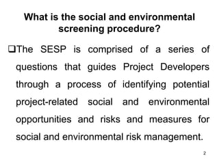
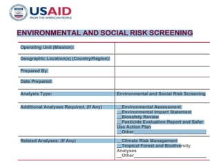
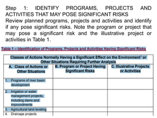
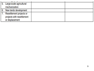
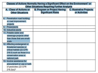
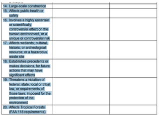
PRESENTED BY
Dr. Revanuru Subramanyam
Professor (Associate), Department of Civil Engineering
Papua New Guinea University of Technology
2023 1
Form for
Environmental and Social Screening,
EMAP and SMAP
What is the social and environmental
screening procedure?
❑The SESP is comprised of a series of
questions that guides Project Developers
through a process of identifying potential
project-related social and environmental
opportunities and risks and measures for
social and environmental risk management.
2
3
ENVIRONMENTAL AND SOCIAL RISK SCREENING TEMPLATE
❑Template is intended to be used when
USAID determines the best strategic
approach for development assistance in a
given country or region, which is articulated
in Country Development Cooperation
Strategy (CDCS) or Regional Development
Cooperation Strategy (RDCS) documents in
order to adequately plan for scheduling and
costs associated with programs, projects
and activities.
4
ENVIRONMENTAL AND SOCIAL RISK SCREENING TEMPLATE
❑ADS 204.3.2.1 recommends conducting an
environmental and social risk review.
❑This Template is used by the strategy planning
team at the Mission to facilitate this review.
❑It identifies program areas, planned projects,
and activities that may present significant
adverse impacts (Step 1) and defines important
considerations, particularly costs and
scheduling, that will affect implementation, e.g.,
if an environmental assessment (EA) is
5
ENVIRONMENTAL AND SOCIAL RISK SCREENING TEMPLATE
required for a planned construction
project (Step 2).
❑The Mission Environmental Officer (MEO)
is available to provide technical assistance
using the Template and can help identify
the potential scheduling and cost
requirements. Subsequently, the risk
reviewfindings should be considered during
project and activity design (Step 3).
6
ENVIRONMENTAL AND SOCIAL RISK SCREENING TEMPLATE
Where practicable, the environmental and
social risk review should be performed in
coordination with the mandatory FAA
118/119 Tropical Forest and Biodiversity
7
8
Step 1: IDENTIFY PROGRAMS, PROJECTS AND
ACTIVITIES THAT MAY POSE SIGNIFICANT RISKS
Review planned programs, projects and activities and identify
if any pose significant risks. Note the program or project that
may pose a significant risk and the illustrative project or
activities in Table 1.
9
10
11
12
13
Step 2: CONSIDERATIONS
For each program, project and activity identified in Table 1, the
following considerations should be noted in the CDCS/RDCS
and communicated to the appropriate operating unit executing
the program, project or activity.
Subsequently this document should be retained for use during
Project and Activity Design (Step 3).
14
1. Scheduling: Most of the actions noted in Table 1 will require
preparation of an EA (22 CFR 216.3(a)(4) and (5)), other
analysis, that could require six to eighteen months to complete,
depending on the complexity and geographic distribution of the
program, project or activity.
These studies should be completed and documented prior to
obligation of funding for the program, project or activity.
If this is not practicable, preparation of a Deferral of
Environmental Analysis is required which needs to be
approved by the Mission Director or Washington equivalent
(Office Director). (EA, Deferral, and other templates are
available at this link.)
2. Costs: The range of estimated costs varies widely, depending on
scope and complexity of the project/activity, could be $200,000 or
more.
3. Project and activity design: Describe initial recommended project
or activity design adjustments to avoid or minimize the noted
potential adverse environmental and social impacts.
15
Table 2 - Program, Project or Activity Considerations
Step 3: PROJECT AND ACTIVITY DESIGN
• As noted above and in ADS 204.3.2.1, the
findings from this screening should be
considered during project and activity
design.
16
EMAP
• The "Environmental Monitoring and
Assessment Program (EMAP)" was developed
in 1988 for the purpose of estimating the
current status, changes, and trends in
indicators of the condition of the nation's
ecological resources on a regional basis;
monitoring of indicators of pollutant exposure
and habitat condition; identifying associations
between human-induced stresses and
ecological condition; and generation of periodic
statistical summaries and interpretive reports on
status and trends to resource managers and
the public.
17
EMAP
❑The EMAP networks will provide statistically
unbiased estimates with quantifiable confidence
limits over regional and national scales for periods
of years to decades.
❑Six broad ecological resource categories have
been defined within EMAP: near-coastal waters,
inland surface waters, wetlands, forests, arid lands,
and agroecosystems.
❑Within each of these categories, EMAP is
determining the ecological resource categories and
resource sampling units that will be assessed in a
series of annual surveys. Indicators of response,
exposure, habitat, and stressors will be defined. 18
EMAP
❑These will determine the types of environmental
assessments that will be conducted, such as
biomarkers, pathogens, bioassays, tissue
concentrations, ambient concentrations, exotics,
habitat structure and landscape pattern.
❑In 1990, EMAP initiated its first demonstration project,
a study of estuaries in the mid Atlantic region.
❑These data will be used for analyses to determine
indices.
❑Additional demonstration projects will be conducted
over the next several years.
❑Full implementation of monitoring in all resources is
being targeted for 1995.
19
Soil Moisture Active Passive Data (SMAP)
• The Soil Moisture Active Passive (SMAP)
mission is an orbiting observatory that
measures the amount of water in the surface
soil everywhere on Earth.
• SMAP data can be used to enhance
understanding of the global processes that
link the water, carbon, and energy cycles, as
well as to improve upon weather and climate
prediction models.
20
Soil Moisture Active Passive Data (SMAP)
❖For example, scientists use SMAP data to:
✓Improve flood warnings by assessing how wet
soil is before rainstorms.
✓Provide early warnings for drought by using
SMAP data to identify soil moisture deficits.
✓Improve crop yield forecasts, plan irrigation,
and improve targeting of humanitarian food
assistance around the world.
✓Improve weather forecasts, as soil moisture is
an important factor in predicting local and
regional weather over a period of days and
weeks. 21
22

Form for Environmental and Social Screening

  • 1.
    PRESENTED BY Dr. RevanuruSubramanyam Professor (Associate), Department of Civil Engineering Papua New Guinea University of Technology 2023 1 Form for Environmental and Social Screening, EMAP and SMAP
  • 2.
    What is thesocial and environmental screening procedure? ❑The SESP is comprised of a series of questions that guides Project Developers through a process of identifying potential project-related social and environmental opportunities and risks and measures for social and environmental risk management. 2
  • 3.
  • 4.
    ENVIRONMENTAL AND SOCIALRISK SCREENING TEMPLATE ❑Template is intended to be used when USAID determines the best strategic approach for development assistance in a given country or region, which is articulated in Country Development Cooperation Strategy (CDCS) or Regional Development Cooperation Strategy (RDCS) documents in order to adequately plan for scheduling and costs associated with programs, projects and activities. 4
  • 5.
    ENVIRONMENTAL AND SOCIALRISK SCREENING TEMPLATE ❑ADS 204.3.2.1 recommends conducting an environmental and social risk review. ❑This Template is used by the strategy planning team at the Mission to facilitate this review. ❑It identifies program areas, planned projects, and activities that may present significant adverse impacts (Step 1) and defines important considerations, particularly costs and scheduling, that will affect implementation, e.g., if an environmental assessment (EA) is 5
  • 6.
    ENVIRONMENTAL AND SOCIALRISK SCREENING TEMPLATE required for a planned construction project (Step 2). ❑The Mission Environmental Officer (MEO) is available to provide technical assistance using the Template and can help identify the potential scheduling and cost requirements. Subsequently, the risk reviewfindings should be considered during project and activity design (Step 3). 6
  • 7.
    ENVIRONMENTAL AND SOCIALRISK SCREENING TEMPLATE Where practicable, the environmental and social risk review should be performed in coordination with the mandatory FAA 118/119 Tropical Forest and Biodiversity 7
  • 8.
    8 Step 1: IDENTIFYPROGRAMS, PROJECTS AND ACTIVITIES THAT MAY POSE SIGNIFICANT RISKS Review planned programs, projects and activities and identify if any pose significant risks. Note the program or project that may pose a significant risk and the illustrative project or activities in Table 1.
  • 9.
  • 10.
  • 11.
  • 12.
  • 13.
    13 Step 2: CONSIDERATIONS Foreach program, project and activity identified in Table 1, the following considerations should be noted in the CDCS/RDCS and communicated to the appropriate operating unit executing the program, project or activity. Subsequently this document should be retained for use during Project and Activity Design (Step 3).
  • 14.
    14 1. Scheduling: Mostof the actions noted in Table 1 will require preparation of an EA (22 CFR 216.3(a)(4) and (5)), other analysis, that could require six to eighteen months to complete, depending on the complexity and geographic distribution of the program, project or activity. These studies should be completed and documented prior to obligation of funding for the program, project or activity. If this is not practicable, preparation of a Deferral of Environmental Analysis is required which needs to be approved by the Mission Director or Washington equivalent (Office Director). (EA, Deferral, and other templates are available at this link.) 2. Costs: The range of estimated costs varies widely, depending on scope and complexity of the project/activity, could be $200,000 or more. 3. Project and activity design: Describe initial recommended project or activity design adjustments to avoid or minimize the noted potential adverse environmental and social impacts.
  • 15.
    15 Table 2 -Program, Project or Activity Considerations
  • 16.
    Step 3: PROJECTAND ACTIVITY DESIGN • As noted above and in ADS 204.3.2.1, the findings from this screening should be considered during project and activity design. 16
  • 17.
    EMAP • The "EnvironmentalMonitoring and Assessment Program (EMAP)" was developed in 1988 for the purpose of estimating the current status, changes, and trends in indicators of the condition of the nation's ecological resources on a regional basis; monitoring of indicators of pollutant exposure and habitat condition; identifying associations between human-induced stresses and ecological condition; and generation of periodic statistical summaries and interpretive reports on status and trends to resource managers and the public. 17
  • 18.
    EMAP ❑The EMAP networkswill provide statistically unbiased estimates with quantifiable confidence limits over regional and national scales for periods of years to decades. ❑Six broad ecological resource categories have been defined within EMAP: near-coastal waters, inland surface waters, wetlands, forests, arid lands, and agroecosystems. ❑Within each of these categories, EMAP is determining the ecological resource categories and resource sampling units that will be assessed in a series of annual surveys. Indicators of response, exposure, habitat, and stressors will be defined. 18
  • 19.
    EMAP ❑These will determinethe types of environmental assessments that will be conducted, such as biomarkers, pathogens, bioassays, tissue concentrations, ambient concentrations, exotics, habitat structure and landscape pattern. ❑In 1990, EMAP initiated its first demonstration project, a study of estuaries in the mid Atlantic region. ❑These data will be used for analyses to determine indices. ❑Additional demonstration projects will be conducted over the next several years. ❑Full implementation of monitoring in all resources is being targeted for 1995. 19
  • 20.
    Soil Moisture ActivePassive Data (SMAP) • The Soil Moisture Active Passive (SMAP) mission is an orbiting observatory that measures the amount of water in the surface soil everywhere on Earth. • SMAP data can be used to enhance understanding of the global processes that link the water, carbon, and energy cycles, as well as to improve upon weather and climate prediction models. 20
  • 21.
    Soil Moisture ActivePassive Data (SMAP) ❖For example, scientists use SMAP data to: ✓Improve flood warnings by assessing how wet soil is before rainstorms. ✓Provide early warnings for drought by using SMAP data to identify soil moisture deficits. ✓Improve crop yield forecasts, plan irrigation, and improve targeting of humanitarian food assistance around the world. ✓Improve weather forecasts, as soil moisture is an important factor in predicting local and regional weather over a period of days and weeks. 21
  • 22.