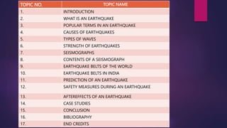
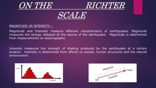
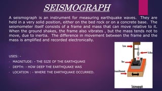
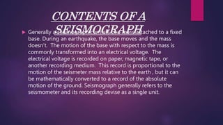
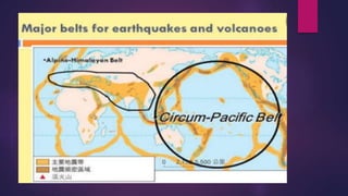
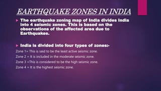
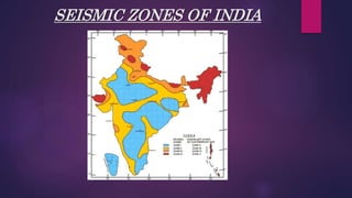
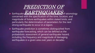
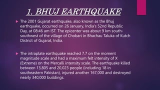
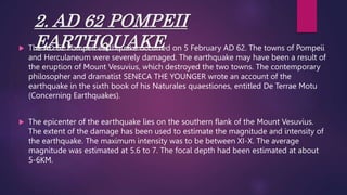
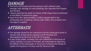
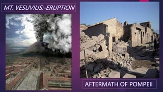
2. I would like to express my heartfelt thanks to my social teacher,
Ms. Alka mam and to our principal mam who gave us this golden
opportunity to do this project on the topic earthquakes which has
helped us to do a lot of research and I came to know about so
many new things.
Secondly, I would also like to thank my dear friends who
supported me through our hardships and helped me to finish the
project successfully!
3. TOPIC NO. TOPIC NAME
1. INTRODUCTION
2. WHAT IS AN EARTHQUAKE
3. POPULAR TERMS IN AN EARTHQUAKE
4. CAUSES OF EARTHQUAKES
5. TYPES OF WAVES
6. STRENGTH OF EARTHQUAKES
7. SEISMOGRAPHS
8. CONTENTS OF A SEISMOGRAPH
9. EARTHQUAKE BELTS OF THE WORLD
10. EARTHQUAKE BELTS IN INDIA
11. PREDICTION OF AN EARTHQUAKE
12. SAFETY MEASURES DURING AN EARTHQUAKE
13. AFTEREFFECTS OF AN EARTHQUAKE
14. CASE STUDIES
15. CONCLUSION
16. BIBLIOGRAPHY
17. END CREDITS
4. INTRODUCTION
As we know EARTHQUAKES are one of the worst natural hazards
which often turn into disasters causing widespread destruction and
loss to human life.
The effects of earthquake vary upon magnitude and intensity.
Earthquakes occur every now and then all around the world. Except
in some places where earthquakes occur rarely. The devastation of
cities and towns is one of the effects of earthquakes.
5. WHAT IS AN EARTHQUAKE..?
• An EARTQUAKE is a sudden movement of the surface of the earth , resulting
from a sudden release of energy in the Earth’s Lithosphere that creates seismic
waves and causes a sudden vibration on the ground which pass through Earth’s
rocks .
• The seismicity or the seismic activity , of an area is the frequency , type and size
of earthquakes experienced over a period of time. These Earthquakes manifest
themselves by shaking or displacing or disrupting the ground , It is known as a
quake , tremor or a tremblor.
• Earthquakes occur mostly in faulty zones , narrow zones where rock masses
move in relation to one another.
6. POPULAR TERMS DURING
EARTHQUAKES
FAULT: A weak point in the tectonic plate
where the edges give way.
FOCUS: Where the earthquake begins. Also
called the hypocenter.
EPICENTRE: The point on the. ground
directly. above the focus.
7. CAUSES OF EARTHQUAKES
• The Earth’s crust consists of seven large lithospheric plates and other
numerous smaller parts.
• Earthquakes are usually caused when rocks which are under the ground
suddenly breaks along a fault. This sudden release of energy causes the
seismic waves that make the ground shake.
• When two blocks of rocks or two plates are rubbing against each other they
stick a little , they don’t just slide up smoothly ; the rocks catch on each other .
The rocks are still pushing against each other but not moving. After a while
the rocks break because of all the pressure that’s built up . When
the rocks break , the EARTHQUAKE occurs .
8. EARTHQUAKES are caused due to 4 major reasons.
1.VOLCANIC ERUPTIONS
Most earthquakes directly beneath a volcano are caused by the
movement of magma . The magma exerts pressure on the rocks
until it cracks the rock . Then the magma squirts into the crack and
starts building pressure again . Every time the rock cracks and thus
it leads to a major earthquake .
9.
10. 2.PLATE TECTONICS
Tectonic Earthquakes occur due to the friction which arises
between them while moving . While these two plates are moving ,
sometimes they collide to each other and when they collide , the
friction between them keeps them locked and unable to move .
These waves which are produced during this colliding of rocks
results in seismic waves which is what we feel during and in an
earthquake site .
11. 3.DUE TO GEOLOGICAL FAULTS
These puzzle pieces are known
as tectonic plates. The plate
Boundaries are made up of so
Many faults, and most of the
Earthquake around the world
Occur on these faults . Since
The edges of the plates are
Rough the get to lock each
Other up and cause
Earthquake
12. 4.NATURAL DISASTERS
There are few minor causes for earthquakes like tsunamis , land
slides In mountain areas , collapse of cavern roofs , and
avalanches which cause perceptible tremors in the earth’s crust .
These earthquakes are however in a small magnitude but few may
become disastrous due to high intensity .
13. TYPES OF WAVES
INTRODUCTION : -
Earthquakes produce three types of seismic waves : -
• Primary waves
• Secondary waves
• Surface waves
Each type moves through materials differently. In addition, the waves can
reflect, or bounce, off boundaries between different layers. The waves can also
bend as they pass from one layer into another. Scientists learn about earths
layers by studying the paths and speeds of seismic waves travelling through
earth.
14. PRIMARY WAVES
The fastest seismic waves are
called primary waves, or P waves.
These waves are first to reach any
particular location after an
earthquake occurs. Primary waves
travel through earth’s crust at an
average speed of about 5km per
sec. Primary waves can travel
through solids, liquids and gases.
As a pass through the material, the
particles of material a slightly
pushed together and pulled apart.
Buildings also experience this push
and pull as primary waves pass
through the ground they are built
on.
15. SECONDARY WAVES
Secondary waves are the second seismic waves to arrive at any particular location after an
earthquake, though they start at the same time as primary waves. Secondary waves
travel through earth’s interior at about half of the speed of the primary waves . secondary
waves are also called “s” waves. As they pass through a material the material’s particles
are shaken up and down are from side to side. Secondary waves rock small building back
and fourth as they pass.
Secondary waves can travel through rock, but unlike primary waves they cannot travel
through liquids and gases. As a primary wave passes through a material, the volume and
density of the material change slightly. But as a secondary passes, the material changes
slightly in shape. Liquids and gases do not have definite shape. These materials flow i.e.,
Particles in them do not return to their original position after being moved.
17. SURFACE WAVES
Surface waves are seismic waves that move along
earth’s surface, not through it’s interior. They make the
ground roll up and down or shake from side to side.
Surface waves cause the largest ground movements
and the most damage. Surface waves travel more
slowly than the types of seismic waves.
18. STRENGTH OF
EARTHQUAKES
The intensity and strength of an earthquake is measured on Richter
scale, the scale invented by Charles Richter California USA in
1935.which categories earthquake on the basis of energy released.
Definition: “the logarithm to base ten of the maximum seismic-wave
amplitude recorded on a standard seismograph at a distance of 100
kilometers from the earthquake epicenter.” Scientists measure the
strength of earthquakes using machines known as seismographs.
Seismology is the scientific study of earthquakes and the
propagation of elastic waves through the Earth.
20. ON THE RICHTER
SCALE
MAGNITUDE VS INTENSITY: -
Magnitude and Intensity measure different characteristics of earthquakes. Magnitude
measures the energy released at the source of the earthquake. Magnitude is determined
from measurements on seismographs.
Intensity measures the strength of shaking produced by the earthquake at a certain
location. Intensity is determined from effects on people, human structures and the natural
environment.
21. SEISMOGRAPH
A seismograph is an instrument for measuring earthquake waves. They are
held in a very solid position, either on the bed rock or on a concrete base. The
seismometer itself consists of a frame and mass that can move relative to it.
When the ground shakes, the frame also vibrates , but the mass tends not to
move, due to inertia. The difference in movement between the frame and the
mass is amplified and recorded electronically.
USES: -
• MAGNITUDE: - THE SIZE OF THE EARTHQUAKE
• DEPTH: - HOW DEEP THE EARTHQUAKE WAS
• LOCATION : - WHERE THE EARTHQUAKE OCCURRED.
22. CONTENTS OF A
SEISMOGRAPH
Generally a seismograph consists of a mass attached to a fixed
base. During an earthquake, the base moves and the mass
doesn’t. The motion of the base with respect to the mass is
commonly transformed into an electrical voltage. The
electrical voltage is recorded on paper, magnetic tape, or
another recording medium. This record is proportional to the
motion of the seismeter mass relative to the earth , but it can
be mathematically converted to a record of the absolute
motion of the ground. Seismograph generally refers to the
seismometer and its recording devise as a single unit.
23. POPULAR BELTS OF THE
EARTHQUAKES
What is an earthquake belt?
A narrow geographic zone on the earths surface along which
most seismic activity occurs is called as an earthquake belt
The two major seismic belts are the Circum-Pacific Belt, which surrounds
the Pacific Ocean,
The Alpine Belt, which stretches from the Azores through the
Mediterranean and Middle East to the Himalayas and Indonesia, where it
joins the Circum-Pacific Belt.
24.
25. EARTHQUAKE ZONES IN INDIA
The earthquake zoning map of India divides India
into 4 seismic zones. This is based on the
observations of the affected area due to
Earthquakes.
India is divided into four types of zones:-
Zone 1= This is said to be the least active seismic zone.
Zone 2 = It is included in the moderate seismic zone.
Zone 3 =This is considered to be the high seismic zone.
Zone 4 = It is the highest seismic zone.
27. PREDICTION OF
EARTHQUAKES
Earthquake prediction is a branch of the science of seismology
concerned with the specification of the time, location, and
magnitude of future earthquakes within stated limits, and
particularly the determination of parameters for the next
strong earthquake to occur in a region.
Earthquake prediction is sometimes distinguished from
earthquake forecasting, which can be defined as the
probabilistic assessment of general earthquake hazard,
including the frequency and magnitude of damaging
earthquakes in a given area over years or decades.
28. NATURAL EATHQUAKE
PREDICTION
Some evidence of upcoming Earthquake are following:
Unusual animal behavior
Water level in wells
Large scale of fluctuation of oil flow from oil wells
Foreshocks or minor shocks before major earthquake
Temperature change
Uplifting of earth surface
Change in seismic wave velocity
Excessive reactions by canaries, macaws and lovebirds (Some birds can
detect seismic activity.)
29. SAFETY MEASURES TO BE
TAKEN DURING AN
EARTHQUAKE
1. QUAKE?! Protect Yourself First.
Be prepared and protect yourself from an earthquake when you hear an
earthquake warning announcement or feel a quake.
Stay under a large table until a quake is gone. Keep yourself safe from
falling or moving objects during a quake.
In high-rise Building with 10 or More Floors, upper floors may be shaken
for several minutes.
Large, slow shakes may let the furniture fall down or move across the
room.
30. 2. Keep Calm. Check All Fire Sources. Put Out Fire Quickly.
If you were using any sources of fire or heat, turn them off when the
shaking calms down.
If a fire starts, put it out quickly and calmly.
3. Keep Calm. Panic May Cause You Injuries.
Be careful of fallen objects or shattered glass in the home.
Stay inside. Roof tiles, broken window glass or signboards may fall
down and hit you.
4. Make Sure You Have Ways Out: Open Doors And Windows.
Make a run for the fire escape as soon as the shaking stops.
31. 5. Keep Away From Gateposts And Walls.
If you feel an earthquake outside, stay away from concrete walls and
other objects which may fall over.
6. Stay Away From Fires And Tsunami.
Take refuge in a temporary assembly spot or an evacuation area
when a fire may threaten your life in the community.
Leave the coast as soon as possible for a higher, safer place when
you are hit by a big quake or hear a tsunami warning at the
seaside.
32. 7. Get The Right Information. Take The Right Action.
Get accurate information from radio, television, fire stations, local
authorities, etc.
8. Make Sure Your Family And Neighbors Are Safe.
After you confirm your family's safety, check if your neighbors are all
right.
9. Work Together On Rescue And First Aid.
Work with your neighbors to free victims from under debris or fallen
furniture and to give first aid.
10. Make Sure Electricity And Gas Are Off Before Evacuation.
Turn off circuit breakers and the gas at the main before you
evacuate.
33. THE AFTER EFFECTS OF
AN EARTHQUAKE
The after effects of an earthquake are terrible and devastating
The environmental effects of it are that including surface faulting, tectonic
uplift, tsunamis, soil liquefactions, ground resonance, landslides and
ground failure, either directly linked to the earthquake source or provoked
by the ground shaking.
SOME MAJOR AFTER EFFECTS OF AN EARTHQUAKE ARE:-
Loss of life and property
Damage to transport system i.e. roads, railways, highways, airports
Damage to infrastructure.
Chances of Floods – Develop cracks in Dams
Chances of fire short-circuit.
Communications such as telephone wires are damaged.
Water pipes, sewers are disrupted
Economic activities like agriculture, industry, trade and transport are
severely affected.
35. 1. BHUJ EARTHQUAKE
The 2001 Gujarat earthquake, also known as the Bhuj
earthquake, occurred on 26 January, India's 52nd Republic
Day, at 08:46 am IST. The epicenter was about 9 km south-
southwest of the village of Chobari in Bhachau Taluka of Kutch
District of Gujarat, India.
The intraplate earthquake reached 7.7 on the moment
magnitude scale and had a maximum felt intensity of X
(Extreme) on the Mercalli intensity scale. The earthquake killed
between 13,805 and 20,023 people (including 18 in
southeastern Pakistan), injured another 167,000 and destroyed
nearly 340,000 buildings.
36. The death toll in the Kutch region was 12,300.
Bhuj, which was situated only 20 km away from
the epicenter, was devastated. Considerable
damage also occurred in Bhachau and Anjar with
hundreds of villages flattened in Taluka of Anjar,
Bhuj and Bhachau. Over one million structures
were damaged or destroyed, including many
historic buildings and tourist attractions. The
quake destroyed around 40% of homes, eight
schools, two hospitals and 4 km of road in Bhuj,
and partly destroyed the city's historic
Swaminarayan temple and historic fort as well
Prag Mahal and Aina Mahal. The Indian National
Trust for Arts and Cultural Heritage (INTACH)
inspected more than 250 heritage buildings in
Kutch and Saurashtra and found that about 40%
of them are either collapsed or seriously
damaged. Only 10% were undamaged.
37. In Ahmedabad, Gujarat's commercial capital with a population of approximately 7 million
(according to data in 2018), as many as 50 multi-storey buildings collapsed and several hundred
people were killed. Total property damage was estimated at $7.5 billion. In Kutch, the earthquake
destroyed about 60% of food and water supplies and around 258,000 houses, 90% of the
district's housing stock. The biggest setback was the total demolition of the Bhuj Civil hospital.
The Indian military provided emergency support which was later augmented by the International
Federation of Red Cross and Red Crescent Society. A temporary Red Cross hospital remained in
Bhuj to provide care while a replacement hospital was built.
38. Relief
In order to support the reconstruction and rehabilitation of the city, the
Government of Gujarat created four assistance packages worth up to
US$1 billion. These packages assisted about 300,000 families. The
government also announced a US$2.5 million package to revive small,
medium, and cottage industries. The World Bank and the Asian Development
Bank also provided loans worth $300 million and $500 million respectively.
Memorial
Smritivan, a memorial park and museum dedicated to victims of the
earthquake is being built on top of Bhujia Hill. 13,823 trees, each dedicated
to a victim, were planted in the garden and 108 small water reservoirs were
created on the hill.
39. 2. AD 62 POMPEII
EARTHQUAKE
The AD 62 Pompeii earthquake occurred on 5 February AD 62. The towns of Pompeii
and Herculaneum were severely damaged. The earthquake may have been a result of
the eruption of Mount Vesuvius, which destroyed the two towns. The contemporary
philosopher and dramatist SENECA THE YOUNGER wrote an account of the
earthquake in the sixth book of his Naturales quaestiones, entitled De Terrae Motu
(Concerning Earthquakes).
The epicenter of the earthquake lies on the southern flank of the Mount Vesuvius.
The extent of the damage has been used to estimate the magnitude and intensity of
the earthquake. The maximum intensity was to be between XI-X. The average
magnitude was estimated at 5.6 to 7. The focal depth had been estimated at about
5-6KM.
40. DAMAGE
The towns of Pompeii and Herculaneum both suffered major
damage, with damage to some buildings also reported from Naples
and Nuceria.
Seneca reported the death of a flock of 600 sheep that he attributed
to the effects of poisonous gases.
Apart from this, approximately, 2 million people died in the
earthquake due to getting crushed under debris, fire accidents and
shortage of supplies.
AFTERMATH
The damage caused by the mainshock and the subsequent series of
tremors was at least partly repaired in both Pompeii and
Herculaneum by the time of the AD 79 eruption.
A pair of bas-reliefs, probably from the LARARIUM in the house of
Lucius Caecilius Lucundus in Pompeii, are interpreted as depicting
the effects of the earthquake on structures including the Temple of
Jupiter, the Aquarium of Cesar, and the Vesuvius Gate.
41.
42. CONCLUSION
An EARTQUAKE is a sudden movement of the surface of the
earth , resulting from a sudden release of energy in the Earth’s
Lithosphere that creates seismic waves and causes a sudden
vibration.
Earthquakes are caused by plate tectonics, geographical faults,
natural disasters and volcanic eruptions.
Earthquakes produce three types of seismic waves Primary
waves, Secondary waves and Surface waves.
A seismograph is an instrument used to measure intensity and
magnitude of an earthquake.
43. There are 2 earthquake belts. They are Circum-Pacific belt and Alpine Belt.
There are 4 zones of earthquakes in India ranging from the least seismic to
most seismic.
The after effects of an earthquake are very fatal and disastrous.
The 2 most disastrous earthquakes of this world are the Bhuj earthquake in
Gujarat and the 62 AD earthquake of Pompeii.
44. SOURCES:-
1. CONTENT SOURCES EXTRACTED FROM WIKIPEDIA, QUORA, ASK.COM,
NDTV NEWS REPORTS, SLIDESHARE INC,THE INCREDIBLE WORLD(NAT
GEO), ATLAS BY PUFFIN SCHOLARS.
2. PICTURE SOURCES EXTRACTED FROM GOOGLE, THE TELEGRAPH, THE POST
REPORTS AND REAL TIME PHOTOGRAPHY IN GUJARAT
45. TEAM SPIRIT
CO-OPERATION WITH TEAM
ACCEPTING ONE’S DECISIONS
MOTIVATION TO WORK TOGETHER
RESPONSIBILITY TO SUBMIT THE WORK