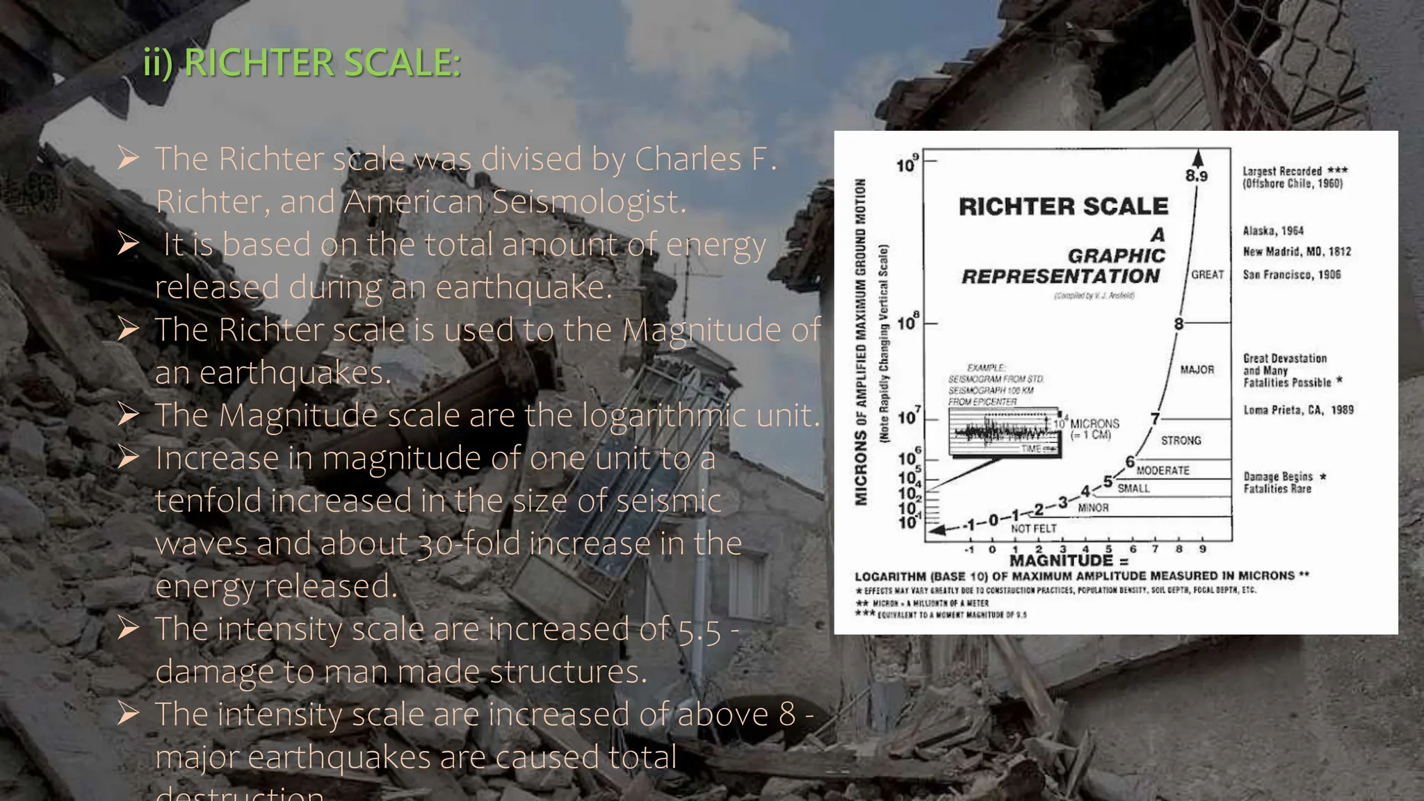
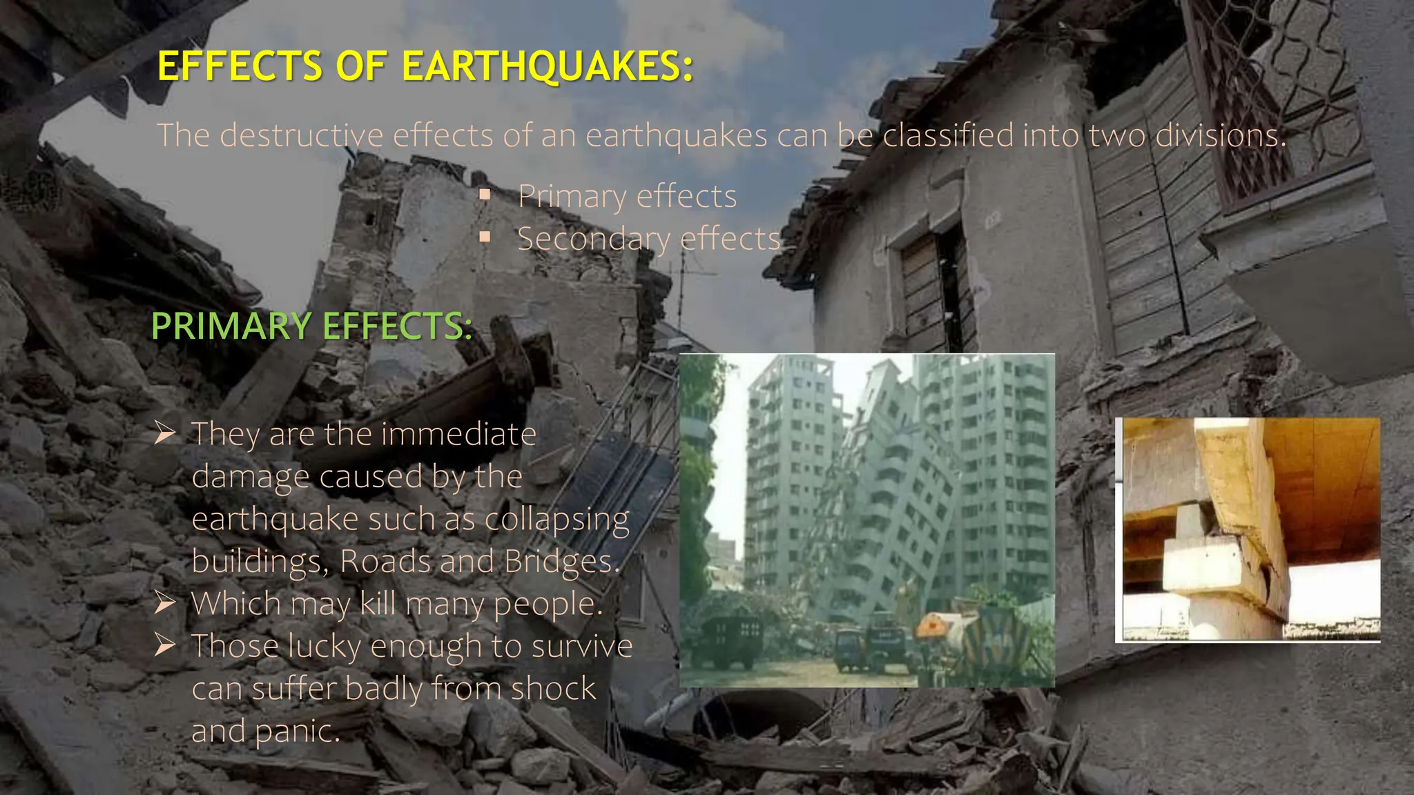
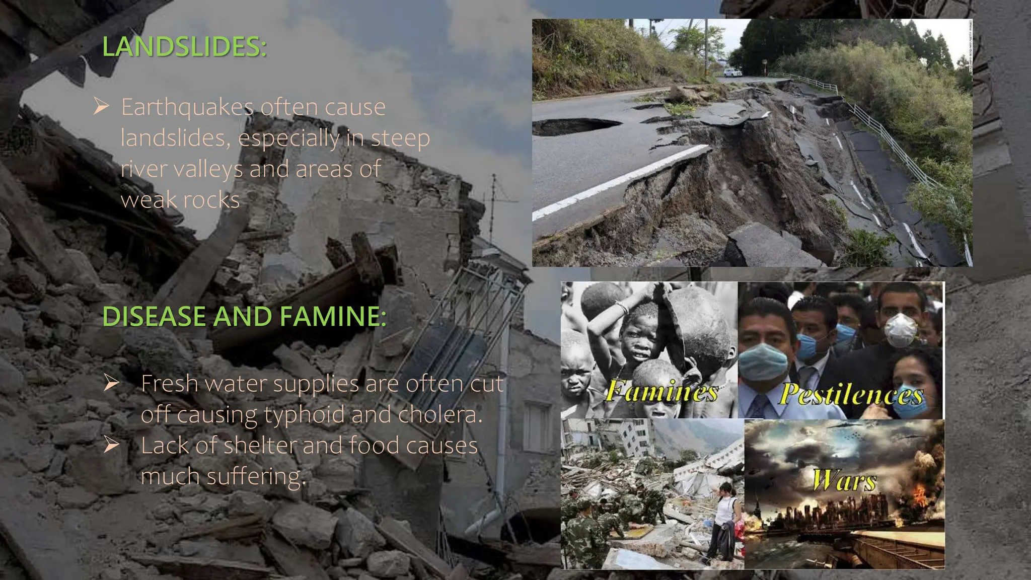
SlideShare a Scribd company logo
Presenting
by,
R.PARIMALA
I – M.Sc., - APPLIED GEOLOGY
EARTHQUAKE
CONTENTS
INTRODUCTION
TERMINOLOGY OF EARTHQUAKE
CLASSIFICATIONOF EARTHQUAKES
WHY EARTHQUAKE FORMS
MEASURESOF EARTHQUAKE
EARTHQUAKEINTENSITY SCALE
PREDICTIONOF EARTHQUAKE
CAUSESOF EARTHQUAKE
EFFECTSOF EARTHQUAKE
 RISK OF EARTHQUAKES
EARTHQUAKEOF INDIA
INTRODUCTION:
 Earthquakes constitute one of the worst natural hazards which
often turn into disaster causing widespread destruction and
loss to human life.
 An Earthquake is the sudden vibration of the earth’s surface by
rapid release of energy.
 This energy is released when two parts of rock masses move
suddenly in relation to each other along a fault.
TERMINOLOGY OF EARTHQUAKE:
FOCUS :
The Focus are otherwise called as hypocenter.
The point of origin of and earthquake within the earth’s crust is called the “Focus”.
From the focus the earthquake waves radiate in all direction.
EPICENTER:
 The point lying vertically above on the earth’s surface, directly above
the focus, is called the “Epicenter”
 Epicenter the shaking Is most intense.
 The intensity gradually decreases outwards.
ISOCLINAL LINES:
 The lines connecting points of equal intensity on the ground surface are
called “Isoseismal line”.
 If the focus is commonly a line, the isoseismal are generally elliptical.
 From the distribution of the lines, the epicenter of an earthquake can be
determined.
FAULTS:
FAULT LINE:
 A fault line is the surface trace of a fault, the line of intersection between the
earth’s surface
FAULT PLANE:
 Fault plane are the crackers or sudden slips of the land.
FAULT SCRAP:
 A fault scrap is the topographic expression of faulting attributed to the
displacement of the land surface movement along faults.
TERMS OF EARTHQUAKE
CLASSIFICATION OF EARTHQUAKES:
CLASSIFICATION-I:
Depending upon their mode of origin, the earthquakes are classified into the following
groups.
1) Earthquake due to surface causes:
Earthquake may be generated by landslips and collapse of the roof of underground
caverns.
Most of these are very minor.
2) Earthquakes due to volcanic causes:
Volcanic eruption may also produce earthquakes but such earthquakes are usually very
feeble.
3) Earthquakes due to tectonic causes:
Tectonic earthquakes are the most numerous and usually the most disastrous.
They are caused by shocks which originate in the earth’s crust due to sudden
movements along faults.
EARTHQUAKE SURFACE
CLASSIFICATION-II:
On the basis of the depth of focus, the earthquakes are divided into the following
1) Shallow focus earthquakes:
Earthquake having depth of focus upro 55km.
2) Intermediate focus earthquakes:
Earthquakes having depth of focus between 55to 300 km.
3) Deep focus earthquakes:
Earthquake shaving depth of focus between 300 to 650 km.
The shallow earthquake s are more violent at the surface but affect a smaller
area than deep earthquakes.
WHY EARTHQUAKE FORMS:
 Geological faults.
 Volcanic eruptions.
 Mine blasts.
 Nuclear tests.
GEOLOGICAL FAULTS:
A fault is a planar fracture or discontinuity in a volume of rock, across which there
has been significant displacement.
There are three main types of faults, namely a) Normal fault. b) Thrust fault.
c) Strike slip fault.
GEOLOGICAL FAULT
NORMAL FAULT:
A normal fault occurs when the crust is extended .
The hanging wall moves downward relative to the
footwall.
THRUST FAULT:
A thrust fault occurs when the crust is
compressed.
The hanging wall moves upward relative to the
footwall.
STRKE SLIP FAULT:
The fault surface is usually near vertical and
motion results from shearing forces.
VOLCANIC ERUPTIONS:
 A volcanic tectonic earthquake is
caused by the movement of magma
beneath the surface of the earth.
 The movement results in pressure
changes where the rock around the
magma has experienced stress.
 At some point, this stress can cause
the rock to break or move.
MINE BLAST:
 The mine blast are caused by seismic
waves produced from the explosion
of rock on the surface.
NUCLEAR TEST:
 A nuclear explosion an earthquake and an
aftershock sequence.
MEASURES OF EARTHQUAKES:
SEISMOGRAPHS:
 “Seismographs” are instruments
which detect and record earthquake
waves.
 Most seismographs contains a heavy
weight suspended from a support
which is attached to bed rocks.
 When waves from a distant
earthquake reach the instrument, the
intertia of the weight keeps it
stationary, while the earth and the
support vibrate.
 The movement of the earth in relation
in the stationary weight is recorded on
a rotating drum.
 Some seismograph detect horizontal
SEISMOGRAMS:
 The trace of the earthquake waves is usually recorded on a travelling photographic
paper as a series of zig-zag lines. These recorded are called “Seismograms”.
 The seismograms the time interval between the arrival of the P and S waves can
be calculated and with the help of the travel-time graph.
 The distance between the recording station and the epicenter is determined.
EARTHQUAKE WAVES:
During an earthquake seismic waves are generated which spread out wants in
all direction from the focus.
The seismic waves are of three types:
i) P – Waves
ii) S – waves
iii) L – waves
i) P – WAVES OR PRIMARY WAVES:
 These are compressional waves which cause the particles of rocks to vibrate
in the longtitunal direction.
 The P – waves travel fastest.
 They reach a seismic station firs.
 Their velocity is 1.7 times than that of S – waves.
 They passing through solids as well as liquids.
S – WAVES OR SECONDARY WAVES:
These are shear waves which are transverse in nature.
Their velocity is less than the P – Waves.
The S – waves travel through solids only and do not pass through liquids.
L – WAVES OR SURFACE WAVES:
 When P - Waves reach the eath’s surface, they are converted into L – Waves.
 The L – Waves travel along the surface and came earthquakes.
 They are transverse in nature and their velocity is much less than the P and S waves.
EARTHQUAKE INTENSITY SACLE:
 The intensity scales have been devised. The two commonly
used intensity scale are ,
i) Rossi Forel scale
ii) Ritchter scale
i)ROSSI FOREL SCALE:
 The Rossi Forel is based on how people behave and react, and howmuch
destruction or disturbance is caused to man made structures and natural
objects.
 The Rossi Forel scale has nine divisions.
 Intensity 1 is given to the weakest earthquake.
 The highest number 9 is assigned to the strongest earthquake. That cause
massive destruction to man made structures and natural objects.
 Intensity above 4 is can damage to properties.
ii) RICHTER SCALE:
 The Richter scale was divised by Charles F.
Richter, and American Seismologist.
 It is based on the total amount of energy
released during an earthquake.
 The Richter scale is used to the Magnitude of
an earthquakes.
 The Magnitude scale are the logarithmic unit.
 Increase in magnitude of one unit to a
tenfold increased in the size of seismic
waves and about 30-fold increase in the
energy released.
 The intensity scale are increased of 5.5 -
damage to man made structures.
 The intensity scale are increased of above 8 -
major earthquakes are caused total
PREDICTION OF EARTHQUAKE:
Earthquake prediction is usually defined as the specification of the Time,
Location and Magnitude of a future earthquake within stated limits.
But some evidence of upcoming earthquake are following:
 Unusual animal behavior.
 Water level in wells.
 Large scale of fluctuation of oil flow from
oil wells.
 Foreshocks or minor shocks before
major earthquake.
 Temperature change.
 Uplifting of earth surface.
 Change in seismic wave velocity.
CAUSES OF EARTHQUAKES:
Earthquake are caused due to sudden
tectonic movements in the earth’s
crust.
When the tectonic plates slide over
one another, there is a cause of
orogeny which result in earthquakes
and volcanoes.
These disturbances cause vibrations
spread in all directions.
As there is a relative motion of these
plates, there is stress built up, which
breaks releasing the stored energy
known as shock waves.
PRIMARY EFFECTS:
EFFECTS OF EARTHQUAKES:
The destructive effects of an earthquakes can be classified into two divisions.
 Primary effects
 Secondary effects
 They are the immediate
damage caused by the
earthquake such as collapsing
buildings, Roads and Bridges.
 Which may kill many people.
 Those lucky enough to survive
can suffer badly from shock
and panic.
SECONDARY EFFECTS:
 They are the after – effects of the earthquake.
 The secondary effects divided into five major effects of earthquake.
FIRE:
 Earthquakes destroy gas pipes and electric
cables, causing fires to spread.
 Broken water mains prevent the fires
being extinguished.
 Fires spread very quickly in cities, especially
in poor – quality housing areas where
wooden building are common
TSUNAMIS::
 An earthquake on the sea floor or
close to the coast may cause huge
waves.
LANDSLIDES:
 Earthquakes often cause
landslides, especially in steep
river valleys and areas of
weak rocks
DISEASE AND FAMINE:
 Fresh water supplies are often cut
off causing typhoid and cholera.
 Lack of shelter and food causes
much suffering.
SOIL LIQUEFACTION:
When soil with a high
water content are
violently shaken they lose
their mechanical strength
and behave like a fluid
and so building can
literally sink.
RISKS OF EARTHQUAKES:
Many seismologist have said that “Earthquake don’t kill people, buildings do”.
This is because most deaths from earthquakes are caused by buildings or
other human construction falling down during an earthquake.
Earthquake located in isolated areas far from human population rarely cause
any deaths.
Thus, Earthquake hazard risk depends on,
1) Population density.
2) Construction standards (Building codes)
3) Emergency preparedness.
 Examples:
 Worst earthquake in recorded history occurred in 1556 in Shaanxi,
China. Killed 8,30,000 peoples.
 Worst earthquake in the 20th century also occurred in china. Killed 2,40000 in 1976.
 Occurred at 3:42 AM, Magnitude 7.1 aftershock.
 Death were due to collapse of masonry (bricks) building.
EARTHQUAKE OF INDIA:
GUJARAT EARTHQUAKE:
 The earthquake was felt in most parts of the century and 20 districts in
the state of Gujarat sustained damage.
 The entire kutch region of Gujarat, enclosed on three sides by the great
Runn of Kutch, The little Runn of kutch and the Arabian sea sustained
highest damage with maximum intensity of shaking as high magnitude
intensity scale.
 25 district of the state was affected in this earthquake.
 Around 18 towns, 182 talukas and 7904 villages in the affected.
 The affected areas even spread up to 300 km from the epicenter.
 Overall 450 villages are totally destroyed.
DAMAGES OF STRUCTURE DURING EARTHQUAKE:
EARTHQUAKE environment notes for geology.pptx

More Related Content

Similar to EARTHQUAKE environment notes for geology.pptx

05 Chapter1
05 Chapter105 Chapter1
05 Chapter1Cms
 
EARTHQUAKE and landscape EARTHQUAKE and landscape.pptx.
EARTHQUAKE and landscape EARTHQUAKE and landscape.pptx.EARTHQUAKE and landscape EARTHQUAKE and landscape.pptx.
EARTHQUAKE and landscape EARTHQUAKE and landscape.pptx.eddingelay
 
Earthquake and earthquake resistant design
Earthquake   and earthquake resistant designEarthquake   and earthquake resistant design
Earthquake and earthquake resistant designPARVEEN JANGRA
 
3.4.1 Earthquake Hazards
3.4.1 Earthquake Hazards3.4.1 Earthquake Hazards
3.4.1 Earthquake Hazardstudorgeog
 
Earthquake resistance buildings
Earthquake resistance buildingsEarthquake resistance buildings
Earthquake resistance buildingsNishtha Lakdawala
 
Earthquake 2014
Earthquake 2014Earthquake 2014
Earthquake 2014ravilbsnaa
 
Aaa earthquake engineering2
Aaa earthquake engineering2Aaa earthquake engineering2
Aaa earthquake engineering2Edz Gapuz
 
A RESEARCH BASED STUDY ON EARTHQUAKES (case study included)
A RESEARCH BASED STUDY ON EARTHQUAKES (case study included)A RESEARCH BASED STUDY ON EARTHQUAKES (case study included)
A RESEARCH BASED STUDY ON EARTHQUAKES (case study included)ishuvishy
 
Earthquake plate tectonic- Geomorphology Chapter
Earthquake plate tectonic- Geomorphology ChapterEarthquake plate tectonic- Geomorphology Chapter
Earthquake plate tectonic- Geomorphology ChapterKaium Chowdhury
 
Earthquakes
EarthquakesEarthquakes
Earthquakes1m4u
 
Ellada texniki.pptx there are slide for ppt
Ellada texniki.pptx there are slide for pptEllada texniki.pptx there are slide for ppt
Ellada texniki.pptx there are slide for pptsabir54817
 

Similar to EARTHQUAKE environment notes for geology.pptx (20)

Presentation
PresentationPresentation
Presentation
 
05 Chapter1
05 Chapter105 Chapter1
05 Chapter1
 
Earthquake
Earthquake Earthquake
Earthquake
 
EARTHQUAKE and landscape EARTHQUAKE and landscape.pptx.
EARTHQUAKE and landscape EARTHQUAKE and landscape.pptx.EARTHQUAKE and landscape EARTHQUAKE and landscape.pptx.
EARTHQUAKE and landscape EARTHQUAKE and landscape.pptx.
 
Earthquake
Earthquake Earthquake
Earthquake
 
Earthquake and earthquake resistant design
Earthquake   and earthquake resistant designEarthquake   and earthquake resistant design
Earthquake and earthquake resistant design
 
3.4.1 Earthquake Hazards
3.4.1 Earthquake Hazards3.4.1 Earthquake Hazards
3.4.1 Earthquake Hazards
 
Earthquake resistance buildings
Earthquake resistance buildingsEarthquake resistance buildings
Earthquake resistance buildings
 
Earthquake 2014
Earthquake 2014Earthquake 2014
Earthquake 2014
 
Endogenous disasters earth quakes
Endogenous disasters   earth quakesEndogenous disasters   earth quakes
Endogenous disasters earth quakes
 
What is an Earthquake.docx
What is an Earthquake.docxWhat is an Earthquake.docx
What is an Earthquake.docx
 
Aaa earthquake engineering2
Aaa earthquake engineering2Aaa earthquake engineering2
Aaa earthquake engineering2
 
A RESEARCH BASED STUDY ON EARTHQUAKES (case study included)
A RESEARCH BASED STUDY ON EARTHQUAKES (case study included)A RESEARCH BASED STUDY ON EARTHQUAKES (case study included)
A RESEARCH BASED STUDY ON EARTHQUAKES (case study included)
 
Earthquake plate tectonic- Geomorphology Chapter
Earthquake plate tectonic- Geomorphology ChapterEarthquake plate tectonic- Geomorphology Chapter
Earthquake plate tectonic- Geomorphology Chapter
 
Earthquakes
EarthquakesEarthquakes
Earthquakes
 
Earthquakes
EarthquakesEarthquakes
Earthquakes
 
Eartquake report
Eartquake reportEartquake report
Eartquake report
 
Ellada texniki.pptx there are slide for ppt
Ellada texniki.pptx there are slide for pptEllada texniki.pptx there are slide for ppt
Ellada texniki.pptx there are slide for ppt
 
Earthquake project
Earthquake projectEarthquake project
Earthquake project
 
Earthquake
EarthquakeEarthquake
Earthquake
 

Recently uploaded

Environmental Impact Assessment (EIA) in Nepal.pptx
Environmental Impact Assessment (EIA) in Nepal.pptxEnvironmental Impact Assessment (EIA) in Nepal.pptx
Environmental Impact Assessment (EIA) in Nepal.pptxAnshu Bhoosal
 
The State Board for Water Pollution - The Water Act 1974 .pptx
The State Board for  Water Pollution - The Water Act 1974  .pptxThe State Board for  Water Pollution - The Water Act 1974  .pptx
The State Board for Water Pollution - The Water Act 1974 .pptxlinciy03
 
WhatsUpp In... Alpine Region concerning Hydrogen Valleys - 16 mai 2024
WhatsUpp In... Alpine Region concerning Hydrogen Valleys - 16 mai 2024WhatsUpp In... Alpine Region concerning Hydrogen Valleys - 16 mai 2024
WhatsUpp In... Alpine Region concerning Hydrogen Valleys - 16 mai 2024Cluster H2O
 
Powers of State Pollution Control Board - The Water Act 1974
Powers of State Pollution Control Board - The Water Act 1974Powers of State Pollution Control Board - The Water Act 1974
Powers of State Pollution Control Board - The Water Act 1974linciy03
 
Powers and Functions of CPCB - The Water Act 1974.pdf
Powers and Functions of CPCB - The Water Act 1974.pdfPowers and Functions of CPCB - The Water Act 1974.pdf
Powers and Functions of CPCB - The Water Act 1974.pdflinciy03
 
SUNDERBANS-a case study(E.V.S. PROJECT).pptx
SUNDERBANS-a case study(E.V.S. PROJECT).pptxSUNDERBANS-a case study(E.V.S. PROJECT).pptx
SUNDERBANS-a case study(E.V.S. PROJECT).pptxKrish DS
 
一比一原版(SUT毕业证)斯威本科技大学毕业证成绩单
一比一原版(SUT毕业证)斯威本科技大学毕业证成绩单一比一原版(SUT毕业证)斯威本科技大学毕业证成绩单
一比一原版(SUT毕业证)斯威本科技大学毕业证成绩单pcoow
 
DRAFT NRW Recreation Strategy - People and Nature thriving together
DRAFT NRW Recreation Strategy - People and Nature thriving togetherDRAFT NRW Recreation Strategy - People and Nature thriving together
DRAFT NRW Recreation Strategy - People and Nature thriving togetherRobin Grant
 
DESERT ECOSYSTEM AND ITS CHARACTERISTICS AND TYPES
DESERT ECOSYSTEM AND ITS CHARACTERISTICS AND TYPESDESERT ECOSYSTEM AND ITS CHARACTERISTICS AND TYPES
DESERT ECOSYSTEM AND ITS CHARACTERISTICS AND TYPESSumayyaSayeeda
 
Micro RNA genes and their likely influence in rice (Oryza sativa L.) dynamic ...
Micro RNA genes and their likely influence in rice (Oryza sativa L.) dynamic ...Micro RNA genes and their likely influence in rice (Oryza sativa L.) dynamic ...
Micro RNA genes and their likely influence in rice (Oryza sativa L.) dynamic ...Open Access Research Paper
 
一比一原版(Monash毕业证)莫纳什大学毕业证成绩单
一比一原版(Monash毕业证)莫纳什大学毕业证成绩单一比一原版(Monash毕业证)莫纳什大学毕业证成绩单
一比一原版(Monash毕业证)莫纳什大学毕业证成绩单qogbuux
 
Genetic diversity and association analysis for different morphological traits...
Genetic diversity and association analysis for different morphological traits...Genetic diversity and association analysis for different morphological traits...
Genetic diversity and association analysis for different morphological traits...Open Access Research Paper
 
Gender and Climate Change in Viet Nam.pdf
Gender and Climate Change in Viet Nam.pdfGender and Climate Change in Viet Nam.pdf
Gender and Climate Change in Viet Nam.pdfTruongPhan43
 
IPCC Vice Chair Ladislaus Change Central Asia Climate Change Conference 27 Ma...
IPCC Vice Chair Ladislaus Change Central Asia Climate Change Conference 27 Ma...IPCC Vice Chair Ladislaus Change Central Asia Climate Change Conference 27 Ma...
IPCC Vice Chair Ladislaus Change Central Asia Climate Change Conference 27 Ma...ipcc-media
 
Prevalence, biochemical and hematological study of diabetic patients
Prevalence, biochemical and hematological study of diabetic patientsPrevalence, biochemical and hematological study of diabetic patients
Prevalence, biochemical and hematological study of diabetic patientsOpen Access Research Paper
 
New Metrics for Sustainable Prosperity: Options for GDP+3 (preliminary study)
New Metrics for Sustainable Prosperity: Options for GDP+3 (preliminary study)New Metrics for Sustainable Prosperity: Options for GDP+3 (preliminary study)
New Metrics for Sustainable Prosperity: Options for GDP+3 (preliminary study)susannedejong
 
一比一原版(Lincoln毕业证)新西兰林肯大学毕业证成绩单
一比一原版(Lincoln毕业证)新西兰林肯大学毕业证成绩单一比一原版(Lincoln毕业证)新西兰林肯大学毕业证成绩单
一比一原版(Lincoln毕业证)新西兰林肯大学毕业证成绩单tyvaq
 
Use of Raffias’ species (Raphia spp.) and its impact on socioeconomic charact...
Use of Raffias’ species (Raphia spp.) and its impact on socioeconomic charact...Use of Raffias’ species (Raphia spp.) and its impact on socioeconomic charact...
Use of Raffias’ species (Raphia spp.) and its impact on socioeconomic charact...Open Access Research Paper
 
CHLORITE( a phyllosilicate clay mineral)
CHLORITE( a phyllosilicate clay mineral)CHLORITE( a phyllosilicate clay mineral)
CHLORITE( a phyllosilicate clay mineral)malleshmalli2994
 

Recently uploaded (20)

Environmental Impact Assessment (EIA) in Nepal.pptx
Environmental Impact Assessment (EIA) in Nepal.pptxEnvironmental Impact Assessment (EIA) in Nepal.pptx
Environmental Impact Assessment (EIA) in Nepal.pptx
 
The State Board for Water Pollution - The Water Act 1974 .pptx
The State Board for  Water Pollution - The Water Act 1974  .pptxThe State Board for  Water Pollution - The Water Act 1974  .pptx
The State Board for Water Pollution - The Water Act 1974 .pptx
 
WhatsUpp In... Alpine Region concerning Hydrogen Valleys - 16 mai 2024
WhatsUpp In... Alpine Region concerning Hydrogen Valleys - 16 mai 2024WhatsUpp In... Alpine Region concerning Hydrogen Valleys - 16 mai 2024
WhatsUpp In... Alpine Region concerning Hydrogen Valleys - 16 mai 2024
 
Powers of State Pollution Control Board - The Water Act 1974
Powers of State Pollution Control Board - The Water Act 1974Powers of State Pollution Control Board - The Water Act 1974
Powers of State Pollution Control Board - The Water Act 1974
 
Powers and Functions of CPCB - The Water Act 1974.pdf
Powers and Functions of CPCB - The Water Act 1974.pdfPowers and Functions of CPCB - The Water Act 1974.pdf
Powers and Functions of CPCB - The Water Act 1974.pdf
 
SUNDERBANS-a case study(E.V.S. PROJECT).pptx
SUNDERBANS-a case study(E.V.S. PROJECT).pptxSUNDERBANS-a case study(E.V.S. PROJECT).pptx
SUNDERBANS-a case study(E.V.S. PROJECT).pptx
 
一比一原版(SUT毕业证)斯威本科技大学毕业证成绩单
一比一原版(SUT毕业证)斯威本科技大学毕业证成绩单一比一原版(SUT毕业证)斯威本科技大学毕业证成绩单
一比一原版(SUT毕业证)斯威本科技大学毕业证成绩单
 
DRAFT NRW Recreation Strategy - People and Nature thriving together
DRAFT NRW Recreation Strategy - People and Nature thriving togetherDRAFT NRW Recreation Strategy - People and Nature thriving together
DRAFT NRW Recreation Strategy - People and Nature thriving together
 
DESERT ECOSYSTEM AND ITS CHARACTERISTICS AND TYPES
DESERT ECOSYSTEM AND ITS CHARACTERISTICS AND TYPESDESERT ECOSYSTEM AND ITS CHARACTERISTICS AND TYPES
DESERT ECOSYSTEM AND ITS CHARACTERISTICS AND TYPES
 
Micro RNA genes and their likely influence in rice (Oryza sativa L.) dynamic ...
Micro RNA genes and their likely influence in rice (Oryza sativa L.) dynamic ...Micro RNA genes and their likely influence in rice (Oryza sativa L.) dynamic ...
Micro RNA genes and their likely influence in rice (Oryza sativa L.) dynamic ...
 
一比一原版(Monash毕业证)莫纳什大学毕业证成绩单
一比一原版(Monash毕业证)莫纳什大学毕业证成绩单一比一原版(Monash毕业证)莫纳什大学毕业证成绩单
一比一原版(Monash毕业证)莫纳什大学毕业证成绩单
 
Genetic diversity and association analysis for different morphological traits...
Genetic diversity and association analysis for different morphological traits...Genetic diversity and association analysis for different morphological traits...
Genetic diversity and association analysis for different morphological traits...
 
Gender and Climate Change in Viet Nam.pdf
Gender and Climate Change in Viet Nam.pdfGender and Climate Change in Viet Nam.pdf
Gender and Climate Change in Viet Nam.pdf
 
IPCC Vice Chair Ladislaus Change Central Asia Climate Change Conference 27 Ma...
IPCC Vice Chair Ladislaus Change Central Asia Climate Change Conference 27 Ma...IPCC Vice Chair Ladislaus Change Central Asia Climate Change Conference 27 Ma...
IPCC Vice Chair Ladislaus Change Central Asia Climate Change Conference 27 Ma...
 
Prevalence, biochemical and hematological study of diabetic patients
Prevalence, biochemical and hematological study of diabetic patientsPrevalence, biochemical and hematological study of diabetic patients
Prevalence, biochemical and hematological study of diabetic patients
 
New Metrics for Sustainable Prosperity: Options for GDP+3 (preliminary study)
New Metrics for Sustainable Prosperity: Options for GDP+3 (preliminary study)New Metrics for Sustainable Prosperity: Options for GDP+3 (preliminary study)
New Metrics for Sustainable Prosperity: Options for GDP+3 (preliminary study)
 
一比一原版(Lincoln毕业证)新西兰林肯大学毕业证成绩单
一比一原版(Lincoln毕业证)新西兰林肯大学毕业证成绩单一比一原版(Lincoln毕业证)新西兰林肯大学毕业证成绩单
一比一原版(Lincoln毕业证)新西兰林肯大学毕业证成绩单
 
Use of Raffias’ species (Raphia spp.) and its impact on socioeconomic charact...
Use of Raffias’ species (Raphia spp.) and its impact on socioeconomic charact...Use of Raffias’ species (Raphia spp.) and its impact on socioeconomic charact...
Use of Raffias’ species (Raphia spp.) and its impact on socioeconomic charact...
 
CHLORITE( a phyllosilicate clay mineral)
CHLORITE( a phyllosilicate clay mineral)CHLORITE( a phyllosilicate clay mineral)
CHLORITE( a phyllosilicate clay mineral)
 
A systematic review of the implementation of Industry 4.0 in human resources
A systematic review of the implementation of Industry 4.0 in human resourcesA systematic review of the implementation of Industry 4.0 in human resources
A systematic review of the implementation of Industry 4.0 in human resources
 

EARTHQUAKE environment notes for geology.pptx

  • 3. CONTENTS INTRODUCTION TERMINOLOGY OF EARTHQUAKE CLASSIFICATIONOF EARTHQUAKES WHY EARTHQUAKE FORMS MEASURESOF EARTHQUAKE EARTHQUAKEINTENSITY SCALE PREDICTIONOF EARTHQUAKE CAUSESOF EARTHQUAKE EFFECTSOF EARTHQUAKE  RISK OF EARTHQUAKES EARTHQUAKEOF INDIA
  • 4. INTRODUCTION:  Earthquakes constitute one of the worst natural hazards which often turn into disaster causing widespread destruction and loss to human life.  An Earthquake is the sudden vibration of the earth’s surface by rapid release of energy.  This energy is released when two parts of rock masses move suddenly in relation to each other along a fault.
  • 5. TERMINOLOGY OF EARTHQUAKE: FOCUS : The Focus are otherwise called as hypocenter. The point of origin of and earthquake within the earth’s crust is called the “Focus”. From the focus the earthquake waves radiate in all direction. EPICENTER:  The point lying vertically above on the earth’s surface, directly above the focus, is called the “Epicenter”  Epicenter the shaking Is most intense.  The intensity gradually decreases outwards.
  • 6. ISOCLINAL LINES:  The lines connecting points of equal intensity on the ground surface are called “Isoseismal line”.  If the focus is commonly a line, the isoseismal are generally elliptical.  From the distribution of the lines, the epicenter of an earthquake can be determined. FAULTS: FAULT LINE:  A fault line is the surface trace of a fault, the line of intersection between the earth’s surface FAULT PLANE:  Fault plane are the crackers or sudden slips of the land. FAULT SCRAP:  A fault scrap is the topographic expression of faulting attributed to the displacement of the land surface movement along faults.
  • 8. CLASSIFICATION OF EARTHQUAKES: CLASSIFICATION-I: Depending upon their mode of origin, the earthquakes are classified into the following groups. 1) Earthquake due to surface causes: Earthquake may be generated by landslips and collapse of the roof of underground caverns. Most of these are very minor. 2) Earthquakes due to volcanic causes: Volcanic eruption may also produce earthquakes but such earthquakes are usually very feeble. 3) Earthquakes due to tectonic causes: Tectonic earthquakes are the most numerous and usually the most disastrous. They are caused by shocks which originate in the earth’s crust due to sudden movements along faults.
  • 10. CLASSIFICATION-II: On the basis of the depth of focus, the earthquakes are divided into the following 1) Shallow focus earthquakes: Earthquake having depth of focus upro 55km. 2) Intermediate focus earthquakes: Earthquakes having depth of focus between 55to 300 km. 3) Deep focus earthquakes: Earthquake shaving depth of focus between 300 to 650 km. The shallow earthquake s are more violent at the surface but affect a smaller area than deep earthquakes.
  • 11. WHY EARTHQUAKE FORMS:  Geological faults.  Volcanic eruptions.  Mine blasts.  Nuclear tests. GEOLOGICAL FAULTS: A fault is a planar fracture or discontinuity in a volume of rock, across which there has been significant displacement. There are three main types of faults, namely a) Normal fault. b) Thrust fault. c) Strike slip fault. GEOLOGICAL FAULT
  • 12. NORMAL FAULT: A normal fault occurs when the crust is extended . The hanging wall moves downward relative to the footwall. THRUST FAULT: A thrust fault occurs when the crust is compressed. The hanging wall moves upward relative to the footwall. STRKE SLIP FAULT: The fault surface is usually near vertical and motion results from shearing forces.
  • 13. VOLCANIC ERUPTIONS:  A volcanic tectonic earthquake is caused by the movement of magma beneath the surface of the earth.  The movement results in pressure changes where the rock around the magma has experienced stress.  At some point, this stress can cause the rock to break or move. MINE BLAST:  The mine blast are caused by seismic waves produced from the explosion of rock on the surface. NUCLEAR TEST:  A nuclear explosion an earthquake and an aftershock sequence.
  • 14. MEASURES OF EARTHQUAKES: SEISMOGRAPHS:  “Seismographs” are instruments which detect and record earthquake waves.  Most seismographs contains a heavy weight suspended from a support which is attached to bed rocks.  When waves from a distant earthquake reach the instrument, the intertia of the weight keeps it stationary, while the earth and the support vibrate.  The movement of the earth in relation in the stationary weight is recorded on a rotating drum.  Some seismograph detect horizontal
  • 15. SEISMOGRAMS:  The trace of the earthquake waves is usually recorded on a travelling photographic paper as a series of zig-zag lines. These recorded are called “Seismograms”.  The seismograms the time interval between the arrival of the P and S waves can be calculated and with the help of the travel-time graph.  The distance between the recording station and the epicenter is determined.
  • 16. EARTHQUAKE WAVES: During an earthquake seismic waves are generated which spread out wants in all direction from the focus. The seismic waves are of three types: i) P – Waves ii) S – waves iii) L – waves i) P – WAVES OR PRIMARY WAVES:  These are compressional waves which cause the particles of rocks to vibrate in the longtitunal direction.  The P – waves travel fastest.  They reach a seismic station firs.  Their velocity is 1.7 times than that of S – waves.  They passing through solids as well as liquids.
  • 17. S – WAVES OR SECONDARY WAVES: These are shear waves which are transverse in nature. Their velocity is less than the P – Waves. The S – waves travel through solids only and do not pass through liquids. L – WAVES OR SURFACE WAVES:  When P - Waves reach the eath’s surface, they are converted into L – Waves.  The L – Waves travel along the surface and came earthquakes.  They are transverse in nature and their velocity is much less than the P and S waves.
  • 18.
  • 19. EARTHQUAKE INTENSITY SACLE:  The intensity scales have been devised. The two commonly used intensity scale are , i) Rossi Forel scale ii) Ritchter scale i)ROSSI FOREL SCALE:  The Rossi Forel is based on how people behave and react, and howmuch destruction or disturbance is caused to man made structures and natural objects.  The Rossi Forel scale has nine divisions.  Intensity 1 is given to the weakest earthquake.  The highest number 9 is assigned to the strongest earthquake. That cause massive destruction to man made structures and natural objects.  Intensity above 4 is can damage to properties.
  • 20. ii) RICHTER SCALE:  The Richter scale was divised by Charles F. Richter, and American Seismologist.  It is based on the total amount of energy released during an earthquake.  The Richter scale is used to the Magnitude of an earthquakes.  The Magnitude scale are the logarithmic unit.  Increase in magnitude of one unit to a tenfold increased in the size of seismic waves and about 30-fold increase in the energy released.  The intensity scale are increased of 5.5 - damage to man made structures.  The intensity scale are increased of above 8 - major earthquakes are caused total
  • 21. PREDICTION OF EARTHQUAKE: Earthquake prediction is usually defined as the specification of the Time, Location and Magnitude of a future earthquake within stated limits. But some evidence of upcoming earthquake are following:  Unusual animal behavior.  Water level in wells.  Large scale of fluctuation of oil flow from oil wells.  Foreshocks or minor shocks before major earthquake.  Temperature change.  Uplifting of earth surface.  Change in seismic wave velocity.
  • 22.
  • 23. CAUSES OF EARTHQUAKES: Earthquake are caused due to sudden tectonic movements in the earth’s crust. When the tectonic plates slide over one another, there is a cause of orogeny which result in earthquakes and volcanoes. These disturbances cause vibrations spread in all directions. As there is a relative motion of these plates, there is stress built up, which breaks releasing the stored energy known as shock waves.
  • 24. PRIMARY EFFECTS: EFFECTS OF EARTHQUAKES: The destructive effects of an earthquakes can be classified into two divisions.  Primary effects  Secondary effects  They are the immediate damage caused by the earthquake such as collapsing buildings, Roads and Bridges.  Which may kill many people.  Those lucky enough to survive can suffer badly from shock and panic.
  • 25. SECONDARY EFFECTS:  They are the after – effects of the earthquake.  The secondary effects divided into five major effects of earthquake.
  • 26. FIRE:  Earthquakes destroy gas pipes and electric cables, causing fires to spread.  Broken water mains prevent the fires being extinguished.  Fires spread very quickly in cities, especially in poor – quality housing areas where wooden building are common TSUNAMIS::  An earthquake on the sea floor or close to the coast may cause huge waves.
  • 27. LANDSLIDES:  Earthquakes often cause landslides, especially in steep river valleys and areas of weak rocks DISEASE AND FAMINE:  Fresh water supplies are often cut off causing typhoid and cholera.  Lack of shelter and food causes much suffering.
  • 28. SOIL LIQUEFACTION: When soil with a high water content are violently shaken they lose their mechanical strength and behave like a fluid and so building can literally sink.
  • 29. RISKS OF EARTHQUAKES: Many seismologist have said that “Earthquake don’t kill people, buildings do”. This is because most deaths from earthquakes are caused by buildings or other human construction falling down during an earthquake. Earthquake located in isolated areas far from human population rarely cause any deaths. Thus, Earthquake hazard risk depends on, 1) Population density. 2) Construction standards (Building codes) 3) Emergency preparedness.  Examples:  Worst earthquake in recorded history occurred in 1556 in Shaanxi, China. Killed 8,30,000 peoples.  Worst earthquake in the 20th century also occurred in china. Killed 2,40000 in 1976.  Occurred at 3:42 AM, Magnitude 7.1 aftershock.  Death were due to collapse of masonry (bricks) building.
  • 30. EARTHQUAKE OF INDIA: GUJARAT EARTHQUAKE:  The earthquake was felt in most parts of the century and 20 districts in the state of Gujarat sustained damage.  The entire kutch region of Gujarat, enclosed on three sides by the great Runn of Kutch, The little Runn of kutch and the Arabian sea sustained highest damage with maximum intensity of shaking as high magnitude intensity scale.  25 district of the state was affected in this earthquake.  Around 18 towns, 182 talukas and 7904 villages in the affected.  The affected areas even spread up to 300 km from the epicenter.  Overall 450 villages are totally destroyed.
  • 31. DAMAGES OF STRUCTURE DURING EARTHQUAKE: