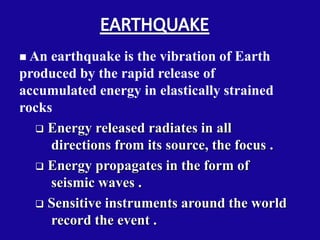
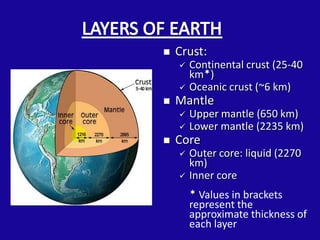
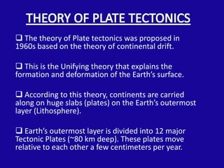
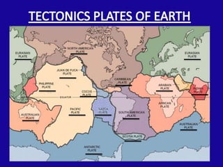
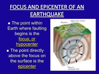
 An earthquake is the vibration of Earth
produced by the rapid release of
accumulated energy in elastically strained
rocks
   Energy released radiates in all
     directions from its source, the focus .
   Energy propagates in the form of
     seismic waves .
   Sensitive instruments around the world
     record the event .
   Crust:
       Continental crust (25-40
        km)
       Oceanic crust (~6 km)
   Mantle
       Upper mantle (650 km)
       Lower mantle (2235 km)
   Core
       Outer core: liquid (2270
        km)
       Inner core
         Values in brackets
        represent the
        approximate thickness of
        each layer
 The theory of Plate tectonics was proposed in
1960s based on the theory of continental drift.

 This is the Unifying theory that explains the
formation and deformation of the Earth’s surface.

 According to this theory, continents are carried
along on huge slabs (plates) on the Earth’s outermost
layer (Lithosphere).

 Earth’s outermost layer is divided into 12 major
Tectonic Plates (~80 km deep). These plates move
relative to each other a few centimeters per year.
 Divergent plate
       boundaries:
  where plates move
         apart
 Convergent Plate
       boundaries:
  where plates come
       together
  Transform plate
       boundaries:
   where plates slide
    past each other
Movement of Tectonic Plates
Earth is divided into sections called Tectonic
plates that float on the fluid-like interior of the
  Earth. Earthquakes are usually caused by
      sudden movement of earth plates
     Rupture of rocks along a fault
Faults are localized areas of weakness in the
 surface of the Earth, sometimes the plate
                boundary itself
  The point within
Earth where faulting
    begins is the
      focus, or
     hypocenter
 The point directly
 above the focus on
  the surface is the
      epicenter
Explains how energy is stored in rocks:
   Rocks bend until the strength of the rock is
      exceeded.
   Rupture occurs and the rocks quickly rebound
      to an undeformed shape.
   Energy is released in waves that radiate
      outward from the fault.
When a earthquake
occurs, two types of seismic
waves are generated:-
 Body waves, that travel
through the interior of the
earth. They are of two types-
 P-wave- primary waves or
    push-pull waves or
    compression waves.
 S-waves- shear
    waves, secondary waves or
    traverse waves.
 Surface waves, that travel
along the surface layers of the
earth. They are of two types-
 Love waves
Rayleigh waves
• INTENSITY                            • MAGNITUDE
 Qualitative measure of an             Quantitative measure of the
  earthquake which describes the         earthquake which is related to
  effect of an earthquake at a           the amount of energy released
  particular location.                   to cause the earthquake.
 Isoseismal lines identify areas of    It is measured by Richter scale
  equal intensity.                       and Seismograph.
 It is measured by modified-           Magnitude is same for a
  mercalli intensity scale.              particular earthquake.
 Intensity changes with distance
  from epicenter of earthquake.
 PEAK GROUND
   MOTION

 DURATION OF
  GROUND MOTION

 FREQUENCY
   CONTENT
 They are the instruments
used to record strong ground
motion i.e. motion large
enough to be potentially
damaging.
These instrument record
acceleration of the ground as
a function of time.
Triaxial acceleographs are
able to measure ground
motion in two perpendicular
horizontal directions and in
the vertical directions.
 EARTHQUAKE MAGNITUDE
 EPICENTRAL DISTANCE
 LOCAL SOIL CONDITION
 CHARACTERISTIC OF LOCAL GEOLOGY ALONG
 THE PROPAGATION PATH
 SOURCE MECHANISM OF THE EARTHQUAKE
 INTERNAL FORCES DUE TO LARGE PEAK GROUND ACCELERATIONS CAUSES
STRUCTURAL FAILURE, LANDSLIDES, RETAINING WALL FAILURE.

 LIQUEFACTION OF SATURATED SOIL CAUSES STRUCTURAL FAILURES, LARGE
LATERAL DISPLACEMENT OF SLOPES, INCREASED LATERAL PRESSURE ON RETAINING
WALL


EARTHQUAKE INDUCED FIRE CAUSES LOSS OF PROPERTY

EARTHQUAKE INDUCED WATER WAVES KNOWN AS TSUNAMIS CAUSE
SUBMERGENCE OF SHORE AREAS CAUSING DEATH AND LOSS OF PROPERTY

RARELY THERE MIGHT BE A PERMANENT CHANGE IN GROUND ELEVATION
 Strange Animal Behavior
  stress in the rocks causes tiny hairline fractures to
  form, the cracking of the rocks evidently emits high
  pitched sounds and minute vibrations imperceptible
  to humans but noticeable by many animals.
 Foreshocks
   unusual increase in the frequency of small
   earthquakes before the main shock
 Changes in water level
   porosity increases or decreases with changes in strain
 Seismic Gaps
   based of the chronological distribution of major
   earthquakes
Prepare a Seismic Risk Map for the globe which identifies rock
types, liquefaction potential, landslide potential.

Extensive geologic surveying has to be done to identify all active
faults, including hidden faults.

Earthquake Resistant Design of Structures
   Enact building codes to design and build earthquake-resistant
   structures in high seismic risk areas. wood, steel and reinforced
   concrete are preferred as they tend to move with the shaking ground
   (unreinforced concrete and heavy masonry tend to move independently
   and in opposition to the shaking, battering one another until the
   structure collapses)

Critical facilities such as nuclear power plants and dams should
be built on stable ground and as far as possible from active faults.
Slide earthquake.

Slide earthquake.

  • 2.
     An earthquakeis the vibration of Earth produced by the rapid release of accumulated energy in elastically strained rocks  Energy released radiates in all directions from its source, the focus .  Energy propagates in the form of seismic waves .  Sensitive instruments around the world record the event .
  • 3.
    Crust:  Continental crust (25-40 km)  Oceanic crust (~6 km)  Mantle  Upper mantle (650 km)  Lower mantle (2235 km)  Core  Outer core: liquid (2270 km)  Inner core  Values in brackets represent the approximate thickness of each layer
  • 4.
     The theoryof Plate tectonics was proposed in 1960s based on the theory of continental drift.  This is the Unifying theory that explains the formation and deformation of the Earth’s surface.  According to this theory, continents are carried along on huge slabs (plates) on the Earth’s outermost layer (Lithosphere).  Earth’s outermost layer is divided into 12 major Tectonic Plates (~80 km deep). These plates move relative to each other a few centimeters per year.
  • 6.
     Divergent plate boundaries: where plates move apart  Convergent Plate boundaries: where plates come together  Transform plate boundaries: where plates slide past each other
  • 7.
    Movement of TectonicPlates Earth is divided into sections called Tectonic plates that float on the fluid-like interior of the Earth. Earthquakes are usually caused by sudden movement of earth plates Rupture of rocks along a fault Faults are localized areas of weakness in the surface of the Earth, sometimes the plate boundary itself
  • 8.
     Thepoint within Earth where faulting begins is the focus, or hypocenter  The point directly above the focus on the surface is the epicenter
  • 9.
    Explains how energyis stored in rocks:  Rocks bend until the strength of the rock is exceeded.  Rupture occurs and the rocks quickly rebound to an undeformed shape.  Energy is released in waves that radiate outward from the fault.
  • 10.
    When a earthquake occurs,two types of seismic waves are generated:-  Body waves, that travel through the interior of the earth. They are of two types-  P-wave- primary waves or push-pull waves or compression waves.  S-waves- shear waves, secondary waves or traverse waves.  Surface waves, that travel along the surface layers of the earth. They are of two types-  Love waves Rayleigh waves
  • 11.
    • INTENSITY • MAGNITUDE  Qualitative measure of an  Quantitative measure of the earthquake which describes the earthquake which is related to effect of an earthquake at a the amount of energy released particular location. to cause the earthquake.  Isoseismal lines identify areas of  It is measured by Richter scale equal intensity. and Seismograph.  It is measured by modified-  Magnitude is same for a mercalli intensity scale. particular earthquake.  Intensity changes with distance from epicenter of earthquake.
  • 12.
     PEAK GROUND MOTION  DURATION OF GROUND MOTION  FREQUENCY CONTENT
  • 13.
     They arethe instruments used to record strong ground motion i.e. motion large enough to be potentially damaging. These instrument record acceleration of the ground as a function of time. Triaxial acceleographs are able to measure ground motion in two perpendicular horizontal directions and in the vertical directions.
  • 15.
     EARTHQUAKE MAGNITUDE EPICENTRAL DISTANCE  LOCAL SOIL CONDITION  CHARACTERISTIC OF LOCAL GEOLOGY ALONG THE PROPAGATION PATH  SOURCE MECHANISM OF THE EARTHQUAKE
  • 16.
     INTERNAL FORCESDUE TO LARGE PEAK GROUND ACCELERATIONS CAUSES STRUCTURAL FAILURE, LANDSLIDES, RETAINING WALL FAILURE.  LIQUEFACTION OF SATURATED SOIL CAUSES STRUCTURAL FAILURES, LARGE LATERAL DISPLACEMENT OF SLOPES, INCREASED LATERAL PRESSURE ON RETAINING WALL EARTHQUAKE INDUCED FIRE CAUSES LOSS OF PROPERTY EARTHQUAKE INDUCED WATER WAVES KNOWN AS TSUNAMIS CAUSE SUBMERGENCE OF SHORE AREAS CAUSING DEATH AND LOSS OF PROPERTY RARELY THERE MIGHT BE A PERMANENT CHANGE IN GROUND ELEVATION
  • 18.
     Strange AnimalBehavior stress in the rocks causes tiny hairline fractures to form, the cracking of the rocks evidently emits high pitched sounds and minute vibrations imperceptible to humans but noticeable by many animals.  Foreshocks unusual increase in the frequency of small earthquakes before the main shock  Changes in water level porosity increases or decreases with changes in strain  Seismic Gaps based of the chronological distribution of major earthquakes
  • 19.
    Prepare a SeismicRisk Map for the globe which identifies rock types, liquefaction potential, landslide potential. Extensive geologic surveying has to be done to identify all active faults, including hidden faults. Earthquake Resistant Design of Structures Enact building codes to design and build earthquake-resistant structures in high seismic risk areas. wood, steel and reinforced concrete are preferred as they tend to move with the shaking ground (unreinforced concrete and heavy masonry tend to move independently and in opposition to the shaking, battering one another until the structure collapses) Critical facilities such as nuclear power plants and dams should be built on stable ground and as far as possible from active faults.