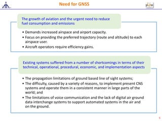
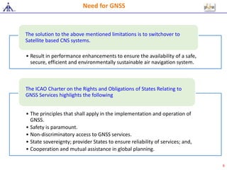
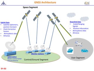
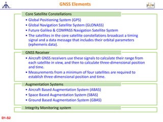
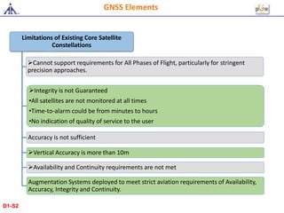
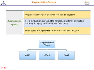
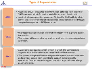
GNSS Overview
1
Topics to be Covered/Objectives
Introduction to GNSS
Need for GNSS
Segments of GNSS
GNSS Elements
Augmentation system
Operation using ABAS/SBAS/GBAS
Advantage of GNSS
Limitations of GNSS
D1-S2
At the end of this session, trainee will be able to:
Describe GNSS and its element
Explain various Augmentation systems
Describe operations using augmentation systems
List advantage and limitation of GNSS
3
D1-S2
Introduction to GNSS
Definition
• A Worldwide position and time determination
system
Components
• One or more satellite constellations
• Aircraft receivers
• Integrity monitoring system
• Augmentation system
4
• Demands increased airspace and airport capacity.
• Focus on providing the preferred trajectory (route and altitude) to each
airspace user.
• Aircraft operators require efficiency gains.
The growth of aviation and the urgent need to reduce
fuel consumption and emissions
• The propagation limitations of ground based line of sight systems;
• The difficulty, caused by a variety of reasons, to implement present CNS
systems and operate them in a consistent manner in large parts of the
world; and
• The limitations of voice communication and the lack of digital air ground
data interchange systems to support automated systems in the air and
on the ground.
Existing systems suffered from a number of shortcomings in terms of their
technical, operational, procedural, economic, and implementation aspects.
Need for GNSS
5
• Result in performance enhancements to ensure the availability of a safe,
secure, efficient and environmentally sustainable air navigation system.
The solution to the above mentioned limitations is to switchover to
Satellite based CNS systems.
• The principles that shall apply in the implementation and operation of
GNSS.
• Safety is paramount.
• Non-discriminatory access to GNSS services.
• State sovereignty; provider States to ensure reliability of services; and,
• Cooperation and mutual assistance in global planning.
The ICAO Charter on the Rights and Obligations of States Relating to
GNSS Services highlights the following
Need for GNSS
6
GNSS Architecture
D1-S2
Control/Ground Segment
User Segment
Space Segment
Uplink Data
• Satellite Ephemeris,
position Constant
• Clock Correction
Factors
• Atmospheric data
• Almanac
Monitor stations
Uplink station
Master Control Center
Ground Antenna
Downlink Data
• Coded Ranging
Signals
• Position Information
• Atmospheric Data
• Almanac
GNSS Architecture
D1-S2
• Global Positioning System (GPS)
• Global Navigation Satellite System (GLONASS)
• Future Galileo & COMPASS Navigation Satellite System
• The satellites in the core satellite constellations broadcast a timing
signal and a data message that includes their orbital parameters
(ephemeris data).
Core Satellite Constellations
• Aircraft GNSS receivers use these signals to calculate their range from
each satellite in view, and then to calculate three-dimensional position
and time.
• Measurements from a minimum of four satellites are required to
establish three-dimensional position and time.
GNSS Receiver
• Aircraft Based Augmentation System (ABAS)
• Space Based Augmentation System (SBAS)
• Ground Based Augmentation System (GBAS)
Augmentation Systems
Integrity Monitoring system
GNSS Elements
D1-S2
• To verify the validity of
satellite signals and
calculate corrections
to enhance accuracy
• The existing core
satellite constellations
alone however do not
meet strict aviation
requirements.
Range from each
satellite
• three-dimensional
position and time
Timing signal;
• Data message that
includes their orbital
parameters (ephemeris
data)
Core Satellite
Constellations
GNSS
Receiver
Integrity
Monitoring
System
Augmentation
System
GNSS Elements
D1-S2
GNSS Elements
Limitations of Existing Core Satellite
Constellations
Cannot support requirements for All Phases of Flight, particularly for stringent
precision approaches.
Integrity is not Guaranteed
•All satellites are not monitored at all times
•Time-to-alarm could be from minutes to hours
•No indication of quality of service to the user
Accuracy is not sufficient
Vertical Accuracy is more than 10m
Availability and Continuity requirements are not met
Augmentation Systems deployed to meet strict aviation requirements of Availability,
Accuracy, Integrity and Continuity.
D1-S2
Augmentation System
Augmentation
Types
ABAS GBAS SBAS
Augmentation
System
“Augmentation” refers to enhancements to a system
It is a method of improving the navigation system's attributes:
accuracy, integrity, availability and Continuity.
Three types of Augmentations in use as in below diagram
D1-S2
Types of Augmentation
• Augments and/or integrates the information obtained from the other
GNSS elements with information available on board the aircraft.
• In avionics implementation, processes GPS and/or GLONASS signals to
deliver the accuracy and reliability required to support enroute through
non-precision approach (NPA) operations.
ABAS
• User receives augmentation information directly from a ground-based
transmitter.
• This system will use monitoring stations at airports to support precision
approach.
GBAS
• A wide coverage augmentation system in which the user receives
augmentation information from a satellite-based transmitter.
• This system uses ground monitoring stations spread across a wide area
and provides signals from satellites to support high availability
operations from en route through to precision approach over a large
geographic area.
SBAS
D1-S2
Operations
using ABAS
Operations
using GBAS
Operations
using SBAS
• RAIM requires redundant satellite range measurements to
detect faulty signals and alert the pilot.
RAIM
• integration of GNSS with other airborne sensors
Inertial Navigation System
• The precision approach service is intended to provide deviation
guidance for final approach segments, while the GBAS
positioning service provides horizontal position information to
support two dimensional RNAV operations in terminal areas.
Precision approach service and GBAS positioning service
Support approaches to multiple runways at a single airport
Approach procedures with vertical guidance (APV)
SBAS can support all en-route and terminal RNAV
operations
Operations using ABAS/SBAS/GBAS
D1-S2
GNSS Benefits & Limitations
GNSS Benefits
1.It has the potential to support all phases of flight by providing seamless global
navigation guidance.
GNSS provides accurate guidance in remote and oceanic areas.
GNSS supports area navigation operations, allowing aircraft to follow more efficient
flight paths.
The availability of accurate GNSS-based guidance on departure supports efficient noise
abatement procedures.
GNSS can improve airport usability, through lower minima, without the need to install a
NAVAID at the airport.
Support such functions as automatic dependent surveillance (ADS) and controller-pilot
data link communications (CPDLC).
The availability of GNSS guidance will allow the phased decommissioning of some or all
of the traditional NAVAIDs
GNSS Limitations
A transition to GNSS represents a major change for all members of the aviation
community. It affects aircraft operators, pilots; air traffic services (ATS) and regulatory
personnel.
A challenge for GNSS is the achievement of a high availability of service. -
Interference with GNSS signals directly affects availability.
The safety of GNSS navigation depends on the accuracy of navigation databases.
D1-S2
Questions?
16
Thank You
D1-S2

#1 gnss overview

  • 1.
  • 2.
    Topics to beCovered/Objectives Introduction to GNSS Need for GNSS Segments of GNSS GNSS Elements Augmentation system Operation using ABAS/SBAS/GBAS Advantage of GNSS Limitations of GNSS D1-S2
  • 3.
    At the endof this session, trainee will be able to: Describe GNSS and its element Explain various Augmentation systems Describe operations using augmentation systems List advantage and limitation of GNSS 3 D1-S2
  • 4.
    Introduction to GNSS Definition •A Worldwide position and time determination system Components • One or more satellite constellations • Aircraft receivers • Integrity monitoring system • Augmentation system 4
  • 5.
    • Demands increasedairspace and airport capacity. • Focus on providing the preferred trajectory (route and altitude) to each airspace user. • Aircraft operators require efficiency gains. The growth of aviation and the urgent need to reduce fuel consumption and emissions • The propagation limitations of ground based line of sight systems; • The difficulty, caused by a variety of reasons, to implement present CNS systems and operate them in a consistent manner in large parts of the world; and • The limitations of voice communication and the lack of digital air ground data interchange systems to support automated systems in the air and on the ground. Existing systems suffered from a number of shortcomings in terms of their technical, operational, procedural, economic, and implementation aspects. Need for GNSS 5
  • 6.
    • Result inperformance enhancements to ensure the availability of a safe, secure, efficient and environmentally sustainable air navigation system. The solution to the above mentioned limitations is to switchover to Satellite based CNS systems. • The principles that shall apply in the implementation and operation of GNSS. • Safety is paramount. • Non-discriminatory access to GNSS services. • State sovereignty; provider States to ensure reliability of services; and, • Cooperation and mutual assistance in global planning. The ICAO Charter on the Rights and Obligations of States Relating to GNSS Services highlights the following Need for GNSS 6
  • 7.
  • 8.
    Control/Ground Segment User Segment SpaceSegment Uplink Data • Satellite Ephemeris, position Constant • Clock Correction Factors • Atmospheric data • Almanac Monitor stations Uplink station Master Control Center Ground Antenna Downlink Data • Coded Ranging Signals • Position Information • Atmospheric Data • Almanac GNSS Architecture D1-S2
  • 9.
    • Global PositioningSystem (GPS) • Global Navigation Satellite System (GLONASS) • Future Galileo & COMPASS Navigation Satellite System • The satellites in the core satellite constellations broadcast a timing signal and a data message that includes their orbital parameters (ephemeris data). Core Satellite Constellations • Aircraft GNSS receivers use these signals to calculate their range from each satellite in view, and then to calculate three-dimensional position and time. • Measurements from a minimum of four satellites are required to establish three-dimensional position and time. GNSS Receiver • Aircraft Based Augmentation System (ABAS) • Space Based Augmentation System (SBAS) • Ground Based Augmentation System (GBAS) Augmentation Systems Integrity Monitoring system GNSS Elements D1-S2
  • 10.
    • To verifythe validity of satellite signals and calculate corrections to enhance accuracy • The existing core satellite constellations alone however do not meet strict aviation requirements. Range from each satellite • three-dimensional position and time Timing signal; • Data message that includes their orbital parameters (ephemeris data) Core Satellite Constellations GNSS Receiver Integrity Monitoring System Augmentation System GNSS Elements D1-S2
  • 11.
    GNSS Elements Limitations ofExisting Core Satellite Constellations Cannot support requirements for All Phases of Flight, particularly for stringent precision approaches. Integrity is not Guaranteed •All satellites are not monitored at all times •Time-to-alarm could be from minutes to hours •No indication of quality of service to the user Accuracy is not sufficient Vertical Accuracy is more than 10m Availability and Continuity requirements are not met Augmentation Systems deployed to meet strict aviation requirements of Availability, Accuracy, Integrity and Continuity. D1-S2
  • 12.
    Augmentation System Augmentation Types ABAS GBASSBAS Augmentation System “Augmentation” refers to enhancements to a system It is a method of improving the navigation system's attributes: accuracy, integrity, availability and Continuity. Three types of Augmentations in use as in below diagram D1-S2
  • 13.
    Types of Augmentation •Augments and/or integrates the information obtained from the other GNSS elements with information available on board the aircraft. • In avionics implementation, processes GPS and/or GLONASS signals to deliver the accuracy and reliability required to support enroute through non-precision approach (NPA) operations. ABAS • User receives augmentation information directly from a ground-based transmitter. • This system will use monitoring stations at airports to support precision approach. GBAS • A wide coverage augmentation system in which the user receives augmentation information from a satellite-based transmitter. • This system uses ground monitoring stations spread across a wide area and provides signals from satellites to support high availability operations from en route through to precision approach over a large geographic area. SBAS D1-S2
  • 14.
    Operations using ABAS Operations using GBAS Operations usingSBAS • RAIM requires redundant satellite range measurements to detect faulty signals and alert the pilot. RAIM • integration of GNSS with other airborne sensors Inertial Navigation System • The precision approach service is intended to provide deviation guidance for final approach segments, while the GBAS positioning service provides horizontal position information to support two dimensional RNAV operations in terminal areas. Precision approach service and GBAS positioning service Support approaches to multiple runways at a single airport Approach procedures with vertical guidance (APV) SBAS can support all en-route and terminal RNAV operations Operations using ABAS/SBAS/GBAS D1-S2
  • 15.
    GNSS Benefits &Limitations GNSS Benefits 1.It has the potential to support all phases of flight by providing seamless global navigation guidance. GNSS provides accurate guidance in remote and oceanic areas. GNSS supports area navigation operations, allowing aircraft to follow more efficient flight paths. The availability of accurate GNSS-based guidance on departure supports efficient noise abatement procedures. GNSS can improve airport usability, through lower minima, without the need to install a NAVAID at the airport. Support such functions as automatic dependent surveillance (ADS) and controller-pilot data link communications (CPDLC). The availability of GNSS guidance will allow the phased decommissioning of some or all of the traditional NAVAIDs GNSS Limitations A transition to GNSS represents a major change for all members of the aviation community. It affects aircraft operators, pilots; air traffic services (ATS) and regulatory personnel. A challenge for GNSS is the achievement of a high availability of service. - Interference with GNSS signals directly affects availability. The safety of GNSS navigation depends on the accuracy of navigation databases. D1-S2
  • 16.
  • 17.