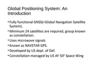
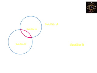
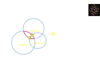
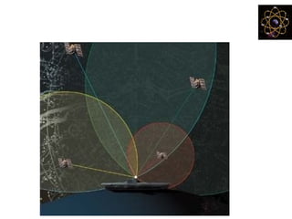
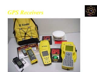
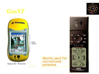
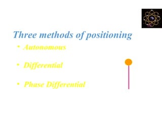
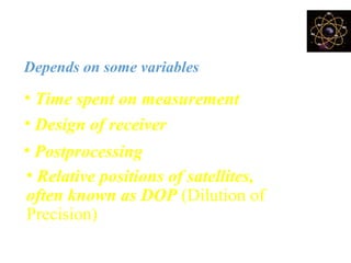
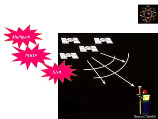
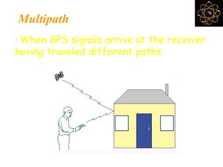
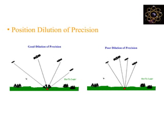
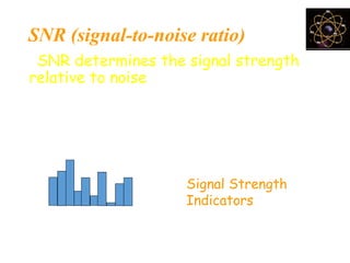
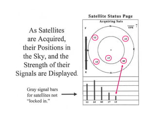
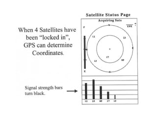
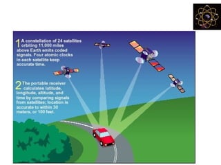
Global Positioning System
Akash Deep Sharma
About the Book
• Date Published: 2008
• ISBN: 978-81-7533-106-8
• Length: 232 pages
• Reprint Unavailable
• Availability: Paperback and Hardcover; Available in Indian
Market
• Cost Rs895/-
About the Book(contd.)
With insights from knowledge about technologies throughout the
world this comprehensive, step-by-step guide includes strategies to
help you:
•Identify what is GPS by giving its introduction.
•Achieve your related goals by using GPS.
•Make familiarization with GPS and related technology.
•Get acquainted to following terms- GPS tracking, Triangulation,
Differential and augmented GPS, GNSS,
•Access commercial assesment of GPS.
About the Book(contd.)
• Access role of GPS in Security related issues.
• Appreciate need of future improvements in GPS and related
technologies.
About the Author
• Akash Deep Sharma has obtained MCA from Jaipuria Inst. of
Management Vasundhra(Ghaziabad).
• Has worked for Private, Government as well as semi Govt. Bodies.
• Has made and implemented software for tracking and monitoring of
traffic through GPS system.
• Has been awarded many study projects from private as well as govt
Universities.
• Presently working at Nimble technologies, New Delhi as developer for
web integration and GPS Systems.
Theme of the book
• This book is a guide for GPS.
• Numerous technical know-how quoted in relation of related
concepts.
• One of the best topic specific book for GPS.
• Increasing use of GPS has made it much more relevant today.
• Lacks updated things about theory which one could find from
other sources.
Global Positioning System
An easy to use
technology for everyone
What is GPS ?
A very precise positioning system
• Developed and maintained by the US
Department of Defense (DOD)
• Satellite Based
* 24 satellites
* 20,200 km high orbit
BUT!
Although it is a very precise
geographic positioning system
•It is very easy to get youself into trouble
•Why?
•Because you (probably) don’t understand
how it works
•And that leads to garbage
Global Positioning System: An
Introduction
•Fully functional GNSS(=Global Navigation Satellite
System).
•Minimum 24 satellites are required, group known
as constellation.
•Uses microwave signals
•Known as NAVSTAR GPS.
•Developed by US dept. of Def.
•Constellation managed by US AF 50th
Space Wing
Global Positioning System: An Introduction
• System has three segments:
1. Space Segment
2. Control Segment
3. User Segment
Characteristics of GPS
• Free
• Precise
• Reliable
• Anytime & anywhere
• All weather
• Unlimited user capacity
Almost!
Segments of GPS
1. Space Segment
A constellation of 24 satellites
2. Monitor Station
A network of earth-based facilities
3. Users & Equipment
Source:Trimble
Segments of GPS
Source:Trimble
1. Space Segment
A constellation
of 24 satellites
GPS Monitoring Station
How GPS Works ………
Uses measurements from 4+ satellites
Distance = travel time x speed of light
Source:Trimble
Determining GPS Position
• Suppose the distance from
Satellite A to our position is
11,000 miles
• At this point we could be located
anywhere on the specified sphere
Satellite A
+
• Next, let us take another measurement
from a second satellite, Satellite BSatellite B
+
• Now our position is narrowed down to the
intersection of theses two sphere
Satellite C
+
Determining GPS Position
Satellite A
Satellite B
+
+
• Taking another measurement
from a 3rd
satellite narrows our
position down even further, to
the two points
• So by ranging from 3 satellites we can
narrow our position to just two points in space
• These points are located where
the 3rd
sphere cuts through the
the intersection of first two spheres
Satellite C
+
How do we decide which one is our
true location?
Satellite A
Satellite B
+
+
• We could make a 4th
measurement
from another satellite to determine
the true point
• However, GPS receivers use a 4th
satellite to precisely
locate our position
• We can eliminate one of the two
points that gives a ridiculous
answer
• The ridiculous point may be too
far from the earth
OR
Determining GPS Position
How accurate is GPS?
Depends on some variables
• Design of receiver
• Relative positions of satellites,
technically known as PDOP (Position
dilution of precision)
• Postprocessing
• Time spent on measurement
GPS Receivers
GeoXT Versus Garmin
Mostly used
for GIS data
collection
Mostly used for
recreational
purposes
Methods of data collection
Three methods of positioning
• Autonomous
10-20 meters
• Differential
2-5 meters
• Phase Differential
centimeter
2-5m10-20 m
cm
How accurate is GPS?
Depends on some variables
• Design of receiver
• Relative positions of satellites,
often known as DOP (Dilution of
Precision)
• Postprocessing
• Time spent on measurement
WAAS
• Wide Area Augmentation System.
• It provides FREE GPS differential correction data for
visible satellites
• Developed & operated by the FAA (Federal Aviation
Administration) for flight navigation but it’s available
free to GPS users
• WAAS-enabled receivers can provide sub-meter level
accuracy anywhere in most locations of the US and
southern Canada.
WAAS
• Differential corrections are computed from
ground stations and then uploaded to
geostationary satellites for broadcasting
• WAAS-enabled GPS receiver automatically
uses such correction data to enhance the
positional accuracy
PDOP
Multipath
SNR
Sources of error
Source:Trimble
Multipath
• When GPS signals arrive at the receiver
having traveled different paths
What is a PDOP?
• Position Dilution of Precision
Good PDOP Poor PDOP
SNR (signal-to-noise ratio)
• SNR determines the signal strength
relative to noise
• GPS position is degraded if the SNR of
one or more satellites in the
constellation falls below certain range
Signal Strength
Indicators
Using Garmin12
Quit ENTER
Goto PAGE
MARK
Scroll
keypad
Cycle
through
pages
Save a
waypoint
On/Off
switch
Common use of GPS
A. GIS data collection & mapping
B. Navigation
C. Recreation
GPS for Navigation
GPS for Navigation
• GPS in PDA
• Are getting popular
in car
• Comes with voice
guidance
GPS in recreation
GPS in Farmland
Future GPS
A. GPS in USA
B. GLONASS program from Russia
C. GALILEO from European countries
GPS Drawing and Tracking
Differential and Augmented GPS
Global Navigation Satellite System
Applied Geo Technology of GPS
GNSS Applications
Commercial Assesment of GPS
National Security Assessment through
GPS
Future Improvements in GPS
• Other nations including India are developing their own Satellite
System for tracking and navigation.
• ​Includes Glonass from Russia, Galellio from EU and Gagan by ISRO.
• ​
Language of the Book
• Language of the Book is easy and it can be understood easily
however there are technical vocab and jargons which one will need
to refer.
Basic Concept
• Basic concept of the book is to give
knowledge about GPS and related
technologies.
• It’s a pure technical book, may prove to
be a boring one if reader lacks technical
aptitude
• A must read for people who come
across such gadgets at daily basis.
Conclusion
• This book is mostly meant for those who
want to develop knowledge about GPS
system and related technologies; it not
only teaches application and
appreciation of this technology but also
explains the concept-the physics and
mathematics at work behind this whole
enabling the end user to give a second
hand experience of its working.

Book Review Global Posiotining System

  • 1.
  • 2.
    About the Book •Date Published: 2008 • ISBN: 978-81-7533-106-8 • Length: 232 pages • Reprint Unavailable • Availability: Paperback and Hardcover; Available in Indian Market • Cost Rs895/-
  • 3.
    About the Book(contd.) Withinsights from knowledge about technologies throughout the world this comprehensive, step-by-step guide includes strategies to help you: •Identify what is GPS by giving its introduction. •Achieve your related goals by using GPS. •Make familiarization with GPS and related technology. •Get acquainted to following terms- GPS tracking, Triangulation, Differential and augmented GPS, GNSS, •Access commercial assesment of GPS.
  • 4.
    About the Book(contd.) •Access role of GPS in Security related issues. • Appreciate need of future improvements in GPS and related technologies.
  • 5.
    About the Author •Akash Deep Sharma has obtained MCA from Jaipuria Inst. of Management Vasundhra(Ghaziabad). • Has worked for Private, Government as well as semi Govt. Bodies. • Has made and implemented software for tracking and monitoring of traffic through GPS system. • Has been awarded many study projects from private as well as govt Universities. • Presently working at Nimble technologies, New Delhi as developer for web integration and GPS Systems.
  • 6.
    Theme of thebook • This book is a guide for GPS. • Numerous technical know-how quoted in relation of related concepts. • One of the best topic specific book for GPS. • Increasing use of GPS has made it much more relevant today. • Lacks updated things about theory which one could find from other sources.
  • 7.
    Global Positioning System Aneasy to use technology for everyone
  • 8.
    What is GPS? A very precise positioning system • Developed and maintained by the US Department of Defense (DOD) • Satellite Based * 24 satellites * 20,200 km high orbit
  • 9.
    BUT! Although it isa very precise geographic positioning system •It is very easy to get youself into trouble •Why? •Because you (probably) don’t understand how it works •And that leads to garbage
  • 10.
    Global Positioning System:An Introduction •Fully functional GNSS(=Global Navigation Satellite System). •Minimum 24 satellites are required, group known as constellation. •Uses microwave signals •Known as NAVSTAR GPS. •Developed by US dept. of Def. •Constellation managed by US AF 50th Space Wing
  • 11.
    Global Positioning System:An Introduction • System has three segments: 1. Space Segment 2. Control Segment 3. User Segment
  • 12.
    Characteristics of GPS •Free • Precise • Reliable • Anytime & anywhere • All weather • Unlimited user capacity Almost!
  • 13.
    Segments of GPS 1.Space Segment A constellation of 24 satellites 2. Monitor Station A network of earth-based facilities 3. Users & Equipment Source:Trimble
  • 14.
    Segments of GPS Source:Trimble 1.Space Segment A constellation of 24 satellites
  • 15.
  • 16.
    How GPS Works……… Uses measurements from 4+ satellites Distance = travel time x speed of light Source:Trimble
  • 17.
    Determining GPS Position •Suppose the distance from Satellite A to our position is 11,000 miles • At this point we could be located anywhere on the specified sphere Satellite A + • Next, let us take another measurement from a second satellite, Satellite BSatellite B + • Now our position is narrowed down to the intersection of theses two sphere
  • 18.
    Satellite C + Determining GPSPosition Satellite A Satellite B + + • Taking another measurement from a 3rd satellite narrows our position down even further, to the two points • So by ranging from 3 satellites we can narrow our position to just two points in space • These points are located where the 3rd sphere cuts through the the intersection of first two spheres
  • 19.
    Satellite C + How dowe decide which one is our true location? Satellite A Satellite B + + • We could make a 4th measurement from another satellite to determine the true point • However, GPS receivers use a 4th satellite to precisely locate our position • We can eliminate one of the two points that gives a ridiculous answer • The ridiculous point may be too far from the earth OR
  • 20.
  • 21.
    How accurate isGPS? Depends on some variables • Design of receiver • Relative positions of satellites, technically known as PDOP (Position dilution of precision) • Postprocessing • Time spent on measurement
  • 22.
  • 23.
    GeoXT Versus Garmin Mostlyused for GIS data collection Mostly used for recreational purposes
  • 24.
    Methods of datacollection Three methods of positioning • Autonomous 10-20 meters • Differential 2-5 meters • Phase Differential centimeter 2-5m10-20 m cm
  • 25.
    How accurate isGPS? Depends on some variables • Design of receiver • Relative positions of satellites, often known as DOP (Dilution of Precision) • Postprocessing • Time spent on measurement
  • 26.
    WAAS • Wide AreaAugmentation System. • It provides FREE GPS differential correction data for visible satellites • Developed & operated by the FAA (Federal Aviation Administration) for flight navigation but it’s available free to GPS users • WAAS-enabled receivers can provide sub-meter level accuracy anywhere in most locations of the US and southern Canada.
  • 27.
    WAAS • Differential correctionsare computed from ground stations and then uploaded to geostationary satellites for broadcasting • WAAS-enabled GPS receiver automatically uses such correction data to enhance the positional accuracy
  • 28.
  • 29.
    Multipath • When GPSsignals arrive at the receiver having traveled different paths
  • 30.
    What is aPDOP? • Position Dilution of Precision Good PDOP Poor PDOP
  • 31.
    SNR (signal-to-noise ratio) •SNR determines the signal strength relative to noise • GPS position is degraded if the SNR of one or more satellites in the constellation falls below certain range Signal Strength Indicators
  • 32.
    Using Garmin12 Quit ENTER GotoPAGE MARK Scroll keypad Cycle through pages Save a waypoint On/Off switch
  • 35.
    Common use ofGPS A. GIS data collection & mapping B. Navigation C. Recreation
  • 36.
  • 37.
    GPS for Navigation •GPS in PDA • Are getting popular in car • Comes with voice guidance
  • 38.
  • 39.
  • 40.
    Future GPS A. GPSin USA B. GLONASS program from Russia C. GALILEO from European countries
  • 42.
  • 43.
  • 44.
  • 45.
  • 46.
  • 47.
  • 48.
  • 49.
    Future Improvements inGPS • Other nations including India are developing their own Satellite System for tracking and navigation. • ​Includes Glonass from Russia, Galellio from EU and Gagan by ISRO. • ​
  • 50.
    Language of theBook • Language of the Book is easy and it can be understood easily however there are technical vocab and jargons which one will need to refer.
  • 51.
    Basic Concept • Basicconcept of the book is to give knowledge about GPS and related technologies. • It’s a pure technical book, may prove to be a boring one if reader lacks technical aptitude • A must read for people who come across such gadgets at daily basis.
  • 52.
    Conclusion • This bookis mostly meant for those who want to develop knowledge about GPS system and related technologies; it not only teaches application and appreciation of this technology but also explains the concept-the physics and mathematics at work behind this whole enabling the end user to give a second hand experience of its working.

Editor's Notes

  • #9 At the cost of 15 billion dollar of your tax money
  • #10 At the cost of 15 billion dollar of your tax money
  • #17 Speed of the light: 186,000 mile/sec 300,000 km/sec 3x10^8 meter/sec
  • #29 SNR is also known as signal strength
  • #30 When SA was on, the position could be anywhere on 1st, 2nd, Alpine, or Spruce street. With SA removed, the position is located with in the road width of +/- 15 feet. (road = 35’, the circle is of 20’ radius). Before the location was within 100 meters, that is the point is about a football field away. Now it’s within the 10 meters. Removal of SA made GPS more useful and handy for our day to day use in cell phone, car, watch etc.
  • #40 Farm equipment capable of producing yield map during harvesting shows how crop yield varies across the field. Allowing farmers to plan fertilizer application for future crops.