Superelevation is the banking of the roadway along a horizontal curve to allow vehicles to safely maneuver the curve at reasonable speeds. As speeds increase and curves tighten, a steeper superelevation rate is required. There are two main methods for distributing superelevation and side friction depending on the roadway type - Method 2 relies primarily on side friction for low speed urban roads, while Method 5 applies both side friction and superelevation for high speed roads and ramps. The document provides formulas and guidelines for determining superelevation rates, runoff lengths, axis of rotation, and placement of superelevation transitions.
2 Superelevation and Spiral Curve ( by Malyar Talash, Highway Design Manager/...Malyar Talash
This document discusses superelevation and spiral curves for road design. It defines superelevation as banking curves to counteract centrifugal force on vehicles. Maximum superelevation rates are recommended based on climate and road type. Methods for achieving superelevation include rotating the pavement surface. Minimum lengths for superelevation runoff and tangent runoff sections are calculated based on design speed, superelevation rate, and other factors. Spiral curves provide a gradual transition between tangent and curved sections and can be used to achieve superelevation runoff. Equations are provided to calculate minimum and maximum spiral lengths. An example problem demonstrates calculating runoff lengths and locating transition points for a road section both with
Geometric Design - Horizontal and vertical curvessachin dass
The document discusses key aspects of highway geometric design including horizontal and vertical alignment. It covers topics such as superelevation design, centrifugal force effects, transition curves, extra widening for curves, and vertical curve types. The key points are:
- Superelevation is used to counteract centrifugal force when negotiating curves, and its design considers factors like design speed, radius of curve, and coefficient of friction.
- Transition curves are used between tangents and circular curves to gradually change curvature and introduce superelevation for driver comfort.
- Extra widening is required for curves to accommodate off-tracking of vehicles and driver tendencies, calculated based on number of lanes, wheel base, design
The document discusses the design of super elevation for haul roads in opencast mines. It explains that super elevation is used to counter the centrifugal force experienced by vehicles turning at curves, preventing them from toppling over. The appropriate super elevation depends on the radius of curvature and vehicle speed, with smaller radii and higher speeds requiring greater super elevation. An equation is provided to calculate the exact super elevation based on these factors. Tables show example super elevations for different radii and speeds. Designers can use this information to determine the minimum radii that require super elevation at specific speeds. The document aims to help ensure haul road safety by providing guidance on super elevation design.
The document discusses the geometric design of roads, specifically horizontal curves. It covers key elements of geometric design like alignment, profile, and cross-section. Horizontal curve design is an important part that influences safety and efficiency. Parameters like design speed, superelevation, extra widening, and minimum radius are discussed in detail according to Indian Road Congress standards. Methods for building superelevation and effecting widening on curves are also summarized.
This document discusses sight distance and horizontal curves, superelevation, and transition curves. It provides the following key points:
1. Sight distance must be provided on horizontal curves to avoid obstructions. The middle ordinate equation calculates the maximum distance an obstruction can be from the centerline while maintaining sight distance.
2. Superelevation is used on curves to counteract centrifugal force. It is expressed as a ratio of outer edge height to width. Maximum rates vary from 4-12% depending on conditions.
3. Transition curves like spirals are used between tangents and curves to gradually change the radius. Their minimum length is calculated using equations involving design speed, radius, and rate
The document discusses various aspects of vertical alignment in transportation infrastructure design and construction. It covers key components like gradient and ruling, the effects of gradient on vehicle resistance, and the design of vertical curves including summit and valley curves. Design parameters discussed include sight distance, centrifugal force, and length determination based on these factors. Equations are provided for calculating curve length and heights. The document also includes examples of previous questions asked on these topics in civil engineering examinations.
Sight distance is an important road design consideration to ensure drivers have adequate visibility of potential hazards. There are two main types of sight distance - stopping sight distance, which is the distance required to stop a vehicle traveling at design speed, and horizontal sight distance, which ensures visibility around curves. Stopping sight distance has two components - reaction distance and braking distance - and is calculated based on design speed, grades, and road conditions. Vertical curves like crests and sags must provide the minimum stopping or headlight sight distance. Horizontal curves also require sight distance calculations to account for roadway geometry. Intersection design must provide adequate sight triangles to allow drivers to see each other and react appropriately.
This chapter discusses the design of horizontal and vertical curves in roadways. It describes different types of horizontal curves like simple, compound, and reverse curves. Minimum radius requirements are based on design speed, superelevation rate, and side friction factors. Stopping sight distance on curves is limited by obstructions and is calculated using the middle ordinate formula. The chapter provides guidelines for balancing curves with grade, drainage, and other design factors.
This document discusses superelevation in InRoads V8i. It provides an overview of superelevation and how it is used to control roadway cross slopes on curves. It explains how to set up a template with the proper constraints for superelevation. It then demonstrates how to apply superelevation using the Table Method, including editing points along the superelevation control lines to achieve the desired results.
3 vertical alignment of road by Malyar TalashMalyar Talash
This document discusses vertical road alignment and provides guidance on vertical curve design. It covers several key topics:
- The influence of topography on vertical alignment and how terrain is classified.
- The two main aspects of vertical alignment: vertical curvature and gradient.
- The two types of vertical curves: crest and sag curves.
- Design considerations for vertical grades and maximum grades based on vehicle type and speed.
- Equations for determining minimum vertical curve lengths to provide adequate sight distance and passenger comfort.
The document discusses geometric design for transportation facilities. It focuses on geometric cross sections, vertical alignment, and horizontal alignment. Geometric cross sections consist of traveled ways, shoulders, and drainage features. Vertical alignment includes tangent grades and vertical curves. Tangent grades vary depending on the type of facility, with maximum grades generally between 3-11% depending on terrain.
Horizontal curves provide a transition between two straight sections of roadway. They are necessary for gradual changes in direction when a direct turn is not feasible. Design considerations for horizontal curves include radius, design speed, side friction, and superelevation. Superelevation transitions consist of runoff sections at the beginning and end of curves to transition the pavement cross-slope from normal to fully banked, or vice versa, over a specified length to maintain safety and comfort.
This document discusses the design of vertical alignment for roads. It defines vertical alignment as the vertical aspect of the road profile, including crest and sag curves. The two basic elements are grades and vertical curves. Grades refer to the rate of rise or fall, while vertical curves provide transitions between sloped roadways and allow gradual elevation changes. The document outlines the types of gradients and vertical curves, and provides the design parameters and equations for determining the length of summit and valley vertical curves based on sight distance and comfort.
This document provides information on geometric design concepts for highways, with a focus on vertical alignment and vertical curves. It includes definitions of terms like gradient, ruling gradient, limiting gradient, minimum gradient, and critical length of grade. It describes factors that influence grades like vehicle speed, acceleration and comfort. It also covers vertical curve fundamentals, including equations for crest and sag vertical curves based on stopping sight distance and headlight sight distance. Examples are provided for calculating sight distances and lengths for different grade change scenarios.
Geometric Design (Transportation Engineering)Hossam Shafiq I
This document provides an outline and content for a course on geometric design (CEE320). It covers key topics like vertical and horizontal alignment, including fundamentals of vertical curves, crest and sag vertical curves, horizontal curve fundamentals, superelevation, and stopping sight distance. Examples are provided to demonstrate calculations for elements like vertical curve length. Design controls and standards from AASHTO and WSDOT are presented for elements such as superelevation rates and side friction factors. The course content is intended to teach students the critical concepts and calculations for geometric roadway design.
In order to have smooth vehicle movements on the roads, the changes in the gradient should be smoothened out by the vertical curves.
The vertical alignment is the elevation or profile of the centre line of the road. The vertical alignment consists of grades and vertical curves.
This document discusses vertical alignment in road design. It defines vertical alignment as the vertical aspect of the road profile, including crest and sag curves. It describes the basic components of vertical alignment as grade and vertical curves. Grade is the slope of the road expressed as a percentage, while vertical curves are parabolic curves that provide gradual transitions between different grades to allow comfortable driving. The document discusses types of vertical curves such as sag curves at the bottom of hills and crest curves at the tops of hills, as well as symmetrical and unsymmetrical curves. It provides the equations used to design different types of vertical curves.
This document provides details for the design of a 108km rural road passing through three districts in Badakhshan Province, Afghanistan. It includes typical road cross sections for different terrains, geometric design values, structural pavement design, drainage structures, retaining walls, and a list of centerline coordinates and elevations. The road requires excavation, embankment filling, asphalt and gravel surfacing, drainage features like culverts and drains, and retaining walls given the mountainous terrain with elevation changes up to 1350m along the route.
This document summarizes an analytical method for investigating three-dimensional stopping sight distance (SSD) adequacy. The method calculates SSD demanded based on vehicle dynamics in 3D environments and SSD available based on the driver's line of sight. It was tested on a 4.3km section of a divided highway with an underground tunnel. The investigation identified locations where SSD demanded exceeded SSD available, providing guidance to improve geometric design elements and ensure adequate SSD.
This document discusses vertical curves on roadways. It defines vertical curves as parabolic curves that provide a smooth transition between two grades. Vertical curves are used at intersections of slopes and to provide safe and comfortable travel for vehicles. There are two types of vertical curves: crest curves (Types I and II) and sag curves (Types III and IV). The document also discusses grades, maximum and minimum grades used for different design speeds, critical lengths of grades, length of vertical curves, and K-values which determine the rate of curvature.
The document discusses transition curves in highways. Transition curves are curves that gradually change the horizontal alignment from straight to circular. This is done to introduce centrifugal force, super elevation, extra widening, and aesthetics gradually for driver comfort and safety. There are three main types of transition curves: spiral, cubic parabola, and lemniscate. The length of the transition curve can be calculated based on the rate of change of centrifugal acceleration, rate of introduction of designed super elevation, or empirical formulas based on vehicle speed and radius of the circular curve. The maximum length from these three criteria is used as the final length of the transition curve.
This document discusses curves used in construction. It begins by stating the learning objectives, which are to explain concepts of curves, identify terminology, differentiate between circular, transition, and vertical curves, explain setting out methods, and calculate setting out of different curve types. It then provides brief descriptions of different curve types - circular curves have constant radius, transition curves connect straight lines of different slopes, and vertical curves connect horizontal alignments of different elevations. The document further explains purposes, geometries, and setting out methods for horizontal, vertical, and transition curves. It concludes by discussing types of circular curves that can have single, changing, or double radii.
Alighnment & horizontal alignment of highway (transportation engineering)Civil Zone
This document discusses the alignment of highways, including horizontal and vertical elements. It covers topics such as grade line, horizontal and vertical curves, sight distance requirements, and super elevation. The key points are:
- Highway alignment consists of horizontal and vertical elements, including tangents and curves. Curves can be simple, compound, spiral, or reverse.
- Grade line refers to the longitudinal slope/rise of the highway. Factors in selecting a grade line include earthwork, terrain, sight distance, flood levels, and groundwater.
- Horizontal alignment deals with tangents and circular curves that connect changes in direction. Vertical alignment includes highway grades and parabolic curves.
- Proper design of curves
Curves are used in transportation infrastructure to provide gradual turns rather than sharp angles. There are two main types of curves: horizontal curves, which provide transitions between sections of roadway; and vertical curves, which provide transitions between changes in elevation. Horizontal curves are further classified as simple, compound, reverse, or spiral curves depending on their design. Vertical curves similarly provide a gradual grade transition. Proper curve design considers factors like design speed, drainage, and sight distance to ensure safety.
1 geometric design elements of road by malyar talashMalyar Talash
This document provides guidelines for road geometric design. It discusses key elements like design speed, sight distance, horizontal and vertical alignment. Design speed determines other elements and impacts safety, mobility and efficiency. Sight distance requirements include stopping sight distance, decision sight distance and intersection sight distance. Horizontal alignment discusses curve types like simple, compound, spiral curves. It provides controls for curvature based on deflection angles and radii.
Vertical alignment of highway (transportation engineering)Civil Zone
Vertical curves are used in highway design to gradually transition between two different slopes or grades. There are two main types - crest vertical curves, which are used on roadway tops, and sag vertical curves, which are used on dips. The minimum length of a vertical curve is determined based on providing the required stopping sight distance for a given design speed. Additional criteria like passenger comfort, drainage, and appearance may also influence the curve length selected. Longer vertical curves generally provide a smoother ride but require more construction costs.
This document provides details of a highway design senior project located in eastern Ethiopia. It includes an introduction describing the need for well-trained engineers and objectives of exposing students to practical design projects. It then gives a brief description of the project area along the Hargele-Afder-Bare-Yet road and scope of the project. The next section focuses on geometric design, including terrain classification, design traffic volumes, functional classification, design standards, and computation of elements for the first horizontal curve.
The document discusses various considerations for designing haul roads in surface mines. It covers types of haul road systems, factors that influence haul road width like vehicle size and capacity, alignment best practices for grades, curves and sight distances, cross section elements, and safety provisions. Proper haul road design requires balancing factors like construction costs, vehicle performance, and safety.
Meter gauge, broad gauge and narrow gaugeparv123family
Meter gauge rail lines are being converted to broader gauges, but some still operate in India including lines from Udaipur to Ahmedabad and Jaipur to Bikaner. Broad gauge lines with double tracks link major cities and ports, followed by single track broad gauge branch lines and then meter gauge double track lines and single track routes. Narrow gauge lines were built in less populated hilly areas of lower economic importance like Pathankot to Manali. Meter gauge uses a 1,000 mm track width, broad gauge uses 1,435 mm, and narrow gauge uses less than 1,000 mm typically 790 mm.
Chris Lally and Danny Beech were awarded scholarships totaling £11,000 to attempt to set the world record for cycling the length of the Pan-American Highway from Alaska to Argentina. Over 4 months, they trained and prepared for the 14,000 mile journey through 14 countries. They began their journey on July 28th in Prudhoe Bay, Alaska. Along the way, they received crucial support from the University of St Andrews alumni network who provided resupply packages and places to stay. However, illness slowed their progress and they ultimately missed breaking the record by 5.5 days, completing the journey in an still impressive time.
various types of steel basically low carbon steels and alloy steels and how the alloying elements alter the various properties of steels , a detailed study & analysis
GUIDELINES FOR MINE HAUL ROAD DESIGN - 2001Edgar Quiroz
This document provides guidelines for designing mine haul roads. It discusses factors to consider such as haul truck size and load capacity, road length, geometry, construction materials, and causes of deterioration. The evolution of haul road design at Syncrude is described, including increasing layer thicknesses and improved construction techniques. Two methods for designing road cross-sections are analyzed: one based on California Bearing Ratio (CBR) and one on critical strain and resilient modulus. Economics of temporary versus semi-permanent haul road designs are also compared. Key considerations for planning road alignment include haul truck stopping distances, sight distances, widths, grades, curves and drainage. Surface materials, base layers, compaction requirements and maintenance are additional topics covered.
This document discusses polymer modified concrete (PMC). It begins by providing background on the early patents for polymer modification of cement and concrete in the 1920s. Styrene-butadiene rubber (SBR) latex is commonly used to produce PMC and improves its flexural and compressive strength as well as durability. The document examines the tensile and compressive strengths of PMC made with varying proportions of polymers like PVA emulsion. PMC has applications in pavements, tunnel linings, bridges and more due to its high performance, low cost, durability and improved strength properties over ordinary concrete.
Nepal has two existing railway lines that are not currently functioning. The government aims to develop 4,000 km of new railway tracks in the next 20 years to connect with India and China. Railway development could benefit Nepal's economy but faces challenges due to the mountainous terrain and need for large investments. The government is working to enact new railway laws and policies to accelerate development efforts.
The document discusses several topics related to vertical curves and superelevation design for roads, including:
1. Equations for parabolic vertical curves and methods for designing vertical curves to connect lines with different grades, including passing a curve through a fixed point.
2. Minimum length requirements for vertical curves based on sight distance standards from AASHTO to ensure safety.
3. Design of unequal tangent vertical curves where the curves on each side have different lengths.
4. Considerations for pavement cross-slope or "crown" and superelevation rates for horizontal curves based on design speed, road classification, climate and other factors.
Here are the steps to solve this problem:
1. Draw the dam cross-section and label dimensions
2. Estimate m-value (number of flow lines across dam) = 10
3. Head drop = Impounded head - Tailwater head = 6.2 - 2.2 = 4 m
4. Length of each flow line = Dam width/m-value = 13/10 = 1.3 m
5. Darcy's law: Q = KA(dh/dl) = (6.1x10⁻⁴ cm/s)(1 m2/100 cm2)(4 m/1.3 m) = 2.32x10⁻³ m3/s
Therefore,
Meter gauge, broad gauge and narrow gaugeParv Garg
There are only a few operational metre gauge rail lines remaining as most are in the process of gauge conversion. Some metre gauge lines still operating are Udaipur-Ahmedabad, Pathankot-Jogindernagar, Jaipur-Bikaner, Marwar-Mavli, and Mathura-Kasganj-Lalkual/Bareilly-Pilibhit-Gonda. Broad gauge lines form a hierarchy with double track lines linking major cities and ports at the top, followed by single track branch lines and then metre gauge double track, single track, and narrow gauge lines. Narrow gauge lines were historically built in less economically important hilly
This document discusses vertical curves used in transportation design. Vertical curves provide a smooth transition between different road or rail grades. They are designed using parabolic equations to maintain a constant rate of change in slope. The key points are:
- Vertical curves connect two different grades using a parabolic shape.
- Their design ensures a constant rate of change in slope for driver comfort.
- The general parabolic equation and methods for computing curve elements like high/low points and elevations at different points are presented.
Indian Railways is the fourth largest commercial or utility employer in the world. It operates over 115,000 km of track across India carrying over 7,500 million passengers and 2.8 million tons of freight annually. While it earns most revenues from freight, it subsidizes passenger fares with freight profits in order to keep fares low. Indian Railways aims to continue expanding operations across 24 states and 3 union territories.
The document discusses different rail gauges used in India for railway tracks. It describes the three main gauges: broad gauge which has a width of 1676 mm, meter gauge of 1000 mm, and narrow gauge of either 762 mm or 610 mm. Broad gauge is used for routes with high traffic volumes and in plain areas. Meter gauge is used when funds are limited. Narrow gauge is suitable for hilly areas with sharp curves. The document outlines the components of a permanent railway track and considerations for an ideal track like uniform gauge and proper super elevation on curves.
The document provides information on highway geometric design elements. It discusses road cross section elements such as the right-of-way, carriageway, shoulders, median, crown slope, side slopes, curbs, and drainage ditches. It also covers geometric design controls and criteria including functional classification, terrain, traffic volume and composition, design vehicle, and design speed. Finally, it discusses elements of geometric design like sight distance, horizontal alignment including tangents and circular curves, and vertical alignment.
The document summarizes information about ferrous metals and steel production processes. It discusses the characteristics of iron ores and how the blast furnace process is used to produce iron from iron ores. The basic oxygen process and electric arc furnace processes are also summarized as methods for producing steel from iron. Key aspects of these steel production methods include using oxygen and electricity respectively to burn off impurities from iron and produce steel alloys with the desired carbon content. Phase diagrams are also discussed as a way to illustrate the changes in iron and steel structures at different carbon levels and temperatures.
The document provides information on various construction materials including reinforcement concrete, finishing materials, fitting materials, and methods of construction. It then discusses steel and non-steel materials. Under steel, it defines iron steel and its types (ingot iron, cast iron, wrought iron, mild steel), and characteristics and uses. It also defines non-iron steel and provides details on copper, aluminum, zinc, bronze and brass. Finally, it covers non-steel materials like glass, plastic and asphalt, stating their types, characteristics and uses.
Rail transportation primarily moves raw materials and low-value manufactured goods over long distances. Rail can be classified into four categories based on shipment size: less than wagonload, wagonload, trainload, and intermodal. Developments in technologies like RO-LA systems have increased rail's use for intermodal shipping. The European Commission aims to shift 30% of highway cargo to rail and sea by 2030 and 50% by 2050 through infrastructure investments and policies. High-speed rail lines have reduced travel times between major cities in several countries.
Railway tracks require stable earthworks to support the ballast, sleepers, and rails. There are several components involved in railway track formation including the subgrade, ballast, and drainage systems. Formations can be constructed as embankments raised above the existing ground level or cuttings made by excavating below ground level. The minimum recommended widths for formations depend on the track gauge and number of lines. Proper slopes and drainage are also important to maintain stability. Various methods like using layers of moorum or rubble, cement grouting, sand piles, or chemical treatments can help stabilize formations built on poor soils.
This document discusses various factors that influence the geometric design of highways, including topography, land use, functional road classification, design speed, design vehicle, traffic volume, environmental and safety considerations, and economics. It describes key elements of horizontal alignment like straights, circular curves, transition curves, superelevation, and curve widening. Minimum radii for circular curves are provided for different design speeds. The objectives and methods for implementing transition curves and superelevation are also summarized.
This document discusses the geometric design of highways, specifically horizontal alignment. It covers key elements of horizontal alignment including horizontal curves, spiral transitions, sight distance, and super elevation. The purpose of horizontal curves is to provide a change in direction while spirals provide a gradual transition. Design is based on relationships between speed, curvature, side friction, and super elevation to prevent skidding and overturning. Methods for calculating minimum radius and attaining proper super elevation are presented.
This document discusses the key considerations for geometric design of highways. It covers standards for rural and urban roads, including lane widths, shoulders, sidewalks and bike lanes. It also discusses elements of horizontal and vertical alignment like curvature, sight distances, super elevation, transitions curves and gradients. Special considerations for designing highways through hilly terrain include ensuring stable slopes, adequate drainage, meeting geometric standards and minimizing unnecessary rises and falls in the road.
This document provides guidelines for sight distance and horizontal alignment design for roadways. It includes tables with recommended values for stopping sight distance, decision sight distance, horizontal curve radii, superelevation rates, and transition lengths. Stopping sight distance is the minimum distance required to stop a vehicle traveling at design speed. Decision sight distance allows additional time for driver maneuvers like avoiding obstacles or changing paths. Designers should provide decision sight distance where unexpected maneuvers may occur. The tables provide minimum curve radii values based on design speed and superelevation rates, with smaller radii allowed for higher superelevation. Superelevation is used to counteract centrifugal force on curves and transition lengths are needed to change cross slopes gradually
This document provides guidelines for using Fleet Productivity Optimization (FPO) software to analyze haul road cycle data from trucks. It discusses collecting representative data using TPMS or data loggers over complete haul cycles. Guidelines are provided for setting logging intervals and ensuring typical payload and cycle. Key features of the haul road are recorded including corners, grades, and rough sections. Composite pressure limits and indices for haul road condition, payload distribution, and overall mine severity are introduced to identify improvement opportunities.
The document discusses the geometric design of highways. It describes key elements that must be considered in highway design like cross section elements, sight distances, horizontal and vertical alignment, and intersections. Sight distance is one of the most important factors for safe vehicle operation and there are two main types: stopping sight distance, which is the minimum distance to stop a vehicle, and overtaking sight distance, which is the minimum distance for safely passing another vehicle. The document provides formulas to calculate stopping sight distances based on factors like vehicle speed, reaction time, gradient, and friction.
This document provides guidance on designing interchanges, including:
- Describing 8 basic interchange types (diamond, cloverleaf, etc.) and their components.
- Establishing a naming convention for interchange ramps.
- Specifying design criteria for elements of a standard diamond interchange like ramp alignments, intersection spacing, ramp terminal types and dimensions, sight distance requirements, and grade adjustments.
- Providing typical sections and diagrams to illustrate concepts.
Research on the Model of Sight Distance Triangle in Mountain HighwayIntersect...IJERA Editor
This document presents research on establishing sight distance triangle models for mountain highway intersections. It analyzes the visual characteristics of drivers and driving characteristics at mountain highway intersections. Due to complex terrain, stopping sight distance is difficult to meet at intersections, making them accident-prone. The research establishes models to calculate safe stopping sight distance for uncontrolled intersections and intersections with minor roads controlled by stop signs. Sight distance triangle models are also developed based on the stopping sight distance models and geometric formulas. The models provide a theoretical basis for designing mountain highway intersections.
Often changes in the direction are necessitated in highway alignment due to various reasons such as topographic considerations, obligatory points.
The geometric design elements pertaining to horizontal alignment of highway should consider safe and comfortable movement of vehicles at the given design speed of the highway.
It is therefore necessary to avoid sudden changes in direction with sharp curves or reverse curves which could not be safely and conveniently negotiated by the vehicles at design speed.
Improper design of horizontal alignment of roads would necessitate speed changes resulting m higher accident rate and increase in vehicle operation cost.
This document discusses key aspects of highway geometric design, including:
- Highway geometric design involves designing elements like cross-sections, horizontal and vertical alignments, sight distances, and intersections within economic limitations and traffic requirements.
- Design controls and criteria are influenced by factors such as road classification, terrain, traffic volumes, design vehicle, design speed, sight distance, and land use.
- Elements of road cross-sections include traffic lanes, shoulders, medians, barriers, curbs, gutters, and sidewalks. Lane and shoulder widths vary based on road type and conditions.
- Horizontal alignment connects straight sections and uses circular curves, which are classified as simple, compound, reverse, or broken back curves based on curvature
The document discusses various elements of highway geometric design including cross-section elements, sight distance considerations, horizontal and vertical alignment details, and intersection elements. It provides guidelines for elements like pavement width, super elevation, horizontal curve radius, and transition curves based on factors such as design speed, terrain, and traffic volume. The key objectives of geometric design elements are to ensure safety, comfort, and efficient traffic flow.
The document discusses design criteria for highways and railways. It addresses consistency as the most important rule in highway design. Drivers expect clear signage and guidance without abrupt changes. The design speed is typically higher than average speeds to allow for future increases. Factors like traffic volume, road classification, terrain and design vehicles influence the number of lanes. Level of service, sight distances, and driver characteristics must also be considered. For railways, equilibrium speed is the balanced speed on a curved track given the cant provided.
The document discusses the key elements of highway geometric design, including cross-section elements, sight distance considerations, horizontal and vertical alignment details, and intersection elements. It outlines several design factors that control geometric design, such as design speed, topography, traffic factors, and environmental factors. Specific cross-section elements covered include pavement surface type and properties, cross slope or camber to drain water, and recommended camber values.
The document discusses various aspects of highway engineering related to horizontal and vertical alignment of roads. It describes extra widening needed on curved sections of roads to accommodate vehicles. It discusses the analysis and formulas to calculate mechanical and psychological widening. It also covers horizontal transition curves, their objectives and methods to determine length. The document discusses setback distance for obstructions on curved sections and the formulas to calculate setback based on sight distance and curve length. It concludes with definitions of gradient, ruling gradient and other types for vertical alignment considerations.
The document discusses various factors in highway geometric design, including cross-sectional elements that influence safety and comfort. It describes design considerations for elements like camber, which provides drainage and friction; carriageway width, which depends on traffic lanes and vehicle size; and kerbs, shoulders, and right-of-way width, which should accommodate all road features and allow for future expansion. Cross-sectional characteristics are important to the performance and lifespan of highways.
Experimental investigation of inmitiable platform on heavy vehicle chassis ij...Dr.Vikas Deulgaonkar
This research paper deals with the experimental investigation of a unique platform structure by evaluation of strain through experimental technique. Strain characteristics at critical locations on the structure are evaluated for dynamic load. Strain gauge categorization for experimentation of the platform structure is described. Different nature of stresses at significant locations is evaluated with the aid of linear and rosette gauges. Present-day data acquisition systems are utilized for acquiring the strain values. Static and dynamic strain values are evaluated for constant speeds on cross-country track.
The experimentation reveals exact strain values, as there are no assumptions for measurement. Cross-country road characteristics are exactly simulated for this measurement process. The optimum vehicle speed is maintained for the entire measurement process. Tri-axial values of strains are calculated using rosette reduction technique. Linear strain values are evaluated on longitudinal members of the platform structure. Values of strain acquired different locations reveal the critical areas of the structure for possible design modifications
CHAPTER 5 Highway capacity and level of service.pptmihiretuTefera
This document discusses determining the capacity and level of service of highways. It provides definitions for key terms like capacity, level of service, and service flow rate. It describes the six levels of service from A to F and factors that affect them like speed, density, and volume-to-capacity ratio. Methods are presented for calculating a highway's service flow rate, adjusting it for lane width and vehicle type, and determining the number of lanes needed based on traffic volumes and desired level of service. An example problem demonstrates applying these concepts to find a highway's current and future levels of service over a 20-year period.
CHAPTER 5 Highway capacity and level of service.pptmihiretuTefera
This document discusses determining the capacity and level of service of highways. It provides definitions for key terms like capacity, level of service, and service flow rate. It describes the six levels of service from A to F and factors that affect level of service like speed, density, and volume-to-capacity ratio. Equations are given for calculating service flow rates based on number of lanes, adjustment factors, and peak hour factors. An example problem demonstrates determining current and future levels of service given traffic growth rates.
This document presents a mathematical model for determining the minimum overtaking sight distance (OSDm) required for an ascending vehicle to safely pass another slower vehicle on a single lane highway with an incline. It defines sight distance, stopping sight distance, perception-reaction time and derives equations to calculate the reaction distance (d1), overtaking distance (d2), vehicle travel distance during overtaking (d3), and total minimum OSDm based on vehicle characteristics, road geometry, and coefficients of friction. The safe overtaking zone is defined as 3 times the minimum OSDm. The model accounts for effects of slope angle and aims to satisfy laws of mechanics for overtaking maneuvers on inclined two-way single lane highways.
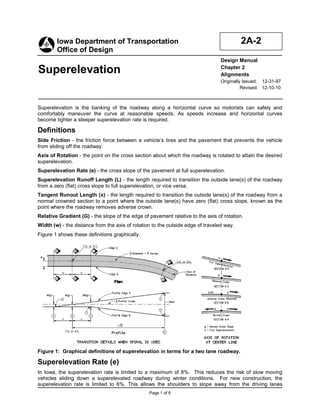
1. Iowa Department of Transportation 2A-2
Office of Design
Design Manual
Superelevation Chapter 2
Alignments
Originally Issued: 12-31-97
Revised: 12-10-10
Superelevation is the banking of the roadway along a horizontal curve so motorists can safely and
comfortably maneuver the curve at reasonable speeds. As speeds increase and horizontal curves
become tighter a steeper superelevation rate is required.
Definitions
Side Friction - the friction force between a vehicle’s tires and the pavement that prevents the vehicle
from sliding off the roadway.
Axis of Rotation - the point on the cross section about which the roadway is rotated to attain the desired
superelevation.
Superelevation Rate (e) - the cross slope of the pavement at full superelevation.
Superelevation Runoff Length (L) - the length required to transition the outside lane(s) of the roadway
from a zero (flat) cross slope to full superelevation, or vice versa.
Tangent Runout Length (x) - the length required to transition the outside lane(s) of the roadway from a
normal crowned section to a point where the outside lane(s) have zero (flat) cross slope, known as the
point where the roadway removes adverse crown.
Relative Gradient (G) - the slope of the edge of pavement relative to the axis of rotation.
Width (w) - the distance from the axis of rotation to the outside edge of traveled way.
Figure 1 shows these definitions graphically.
Figure 1: Graphical definitions of superelevation in terms for a two lane roadway.
Superelevation Rate (e)
In Iowa, the superelevation rate is limited to a maximum of 8%. This reduces the risk of slow moving
vehicles sliding down a superelevated roadway during winter conditions. For new construction, the
superelevation rate is limited to 6%. This allows the shoulders to slope away from the driving lanes
Page 1 of 8
2. Chapter 2—Alignments Section 2A-2—Superelevation
without exceeding AASHTO’s 8 percent maximum value for crossover breaks. The superelevation rate
for new urban facilities is limited to 4% due to the frequency of cross streets, driveways, and entrances
adjoining the curve, as well as the possibility of vehicles stopping on the curve at signalized intersections.
The Department’s current policy on maximum superelevation rates are summarized in Table 1.
Table 1: Maximum superelevation rates.
Rural Facilities Urban Facilities
New or Reconstruction 6% 4%
Maintain original
3R/4R design up to 8% 6%
unless problems exist
Superelevation and Side Friction
Side Friction Demand Factor
The side friction demand is the amount of friction required for a given velocity and geometric design.
The following formula shows the relationship between side friction demand, superelevation rate,
speed, and radius of curvature.
v2 e
fd = −
gR 100
where:
v= velocity of the vehicle, ft/s (m/s).
2 2
g = gravity, 32.2 ft/s (9.81 m/s ).
R = radius of the curve, ft (m).
e = superelevation rate, %.
Maximum Side Friction Factors (fmax)
When establishing the maximum side friction factor to use for horizontal curve design, the vehicle’s
need for side friction, as well as driver comfort, must be taken into account.
Side Friction (vehicle’s need)
A vehicle will begin to skid when the side friction demand equals the maximum amount of friction
that can be developed between the tires and the pavement. This maximum friction, with a factor
of safety to account for variations in the speed, tire conditions, and pavement conditions, is the
maximum design friction factor based upon vehicle need.
Side Friction (driver comfort)
Through a horizontal curve, drivers can experience a feeling of being pushed outward. If this
feeling becomes uncomfortable, the driver will compensate by flattening out their path (increasing
R) or braking (decreasing v) to reduce lateral acceleration, and subsequently fd, to an acceptable
level. Often it is the driver’s comfort that determines the superelevation requirements, not the
vehicle and roadway characteristics. On low speed roadways, drivers will accept more lateral
acceleration, thus permitting a larger side friction demand. As speeds increase, drivers become
less tolerant of lateral acceleration, requiring a reduction in side friction demand.
Based upon research of the above factors, AASHTO’s A Policy on Geometric Design of Highways
and Streets lists maximum side friction factors for use in design of horizontal curves. These are
summarized in Table 2 below.
Page 2 of 8
3. Chapter 2—Alignments Section 2A-2—Superelevation
Table 2: Maximum side friction factors
Design Speed Design Speed
fmax fmax
(mph) (mph)
15 0.32 50 0.14
20 0.27 55 0.13
25 0.23 60 0.12
30 0.20 65 0.11
35 0.18 70 0.10
40 0.16 75 0.09
45 0.15 80 0.08
Distribution of Superelevation (e) and Side Friction (f)
Chapter 3 of AASHTO’s A Policy on Geometric Design of Highways and Streets discusses five
methods of controlling lateral acceleration on curves using e, f, or both. Iowa DOT uses Method 2 and
Method 5 depending upon the type of roadway.
Low speed urban roadways
o Method 2: friction is primarily used to control lateral acceleration and superelevation is added
only when side friction would exceed acceptable values.
Drivers are willing to accept more discomfort on low speed urban roadways due to the anticipation of
more critical conditions. In addition, several factors make it difficult, if not impossible, to apply
superelevation to urban roadways:
• Frequency of cross streets and driveways.
• Vehicles stopping on curves at signalized intersections.
• Meeting the grade of adjacent properties.
• Surface drainage.
• Pedestrian ramps.
• Wider pavement area.
Method 2 is well suited for low speed urban roadways, since it relies first on side friction, then on
superelevation to control lateral acceleration. The relationship between superelevation rate and
minimum radius for Method 2 distribution can be expressed as follows:
V2
Rmin =
15(0.01emax + f max )
where:
V= design speed, mph.
emax = maximum superelevation rate, %.
fmax = maximum friction factor for the design speed.
R= Radius of the curve, feet.
Table 14 of Section 2A-3 provides minimum turning radii for various superelevation rates and design
speeds.
High speed roadways or ramps
o Method 5: side friction and superelevation are both applied using a curvilinear relationship
with the inverse of the radius.
At higher speeds, drivers are less comfortable with lateral acceleration through curves. Method 5,
works well for determining the distribution of superelevation and side friction for high speed roadways,
Page 3 of 8
4. Chapter 2—Alignments Section 2A-2—Superelevation
because superelevation is progressively added as speed increases. It also works well for turning
roadways such as ramps.
Superelevation tables for high speed roadways are included in Section 2A-3.The superelevation rate
for Method 5 distribution can also be calculated manually using the equations provided in
AASHTO’s A Policy on Geometric Design of Highways and Streets. When calculating superelevation
rates manually round values of e up to the nearest 2/10ths of a percent. An Excel file has been
created using these formulas and is provided at the link below.
Superelevation Spreadsheet
Axis of Rotation
The axis of rotation is the point on the cross section about which the roadway is rotated to attain the
desired superelevation. For standard situations the axis of rotation is shown on the appropriate Standard
Road Plan (PV series). For cases not covered by the Standards, the axis of rotation should be
clearly shown on the typical cross section.
Undivided highways should be superelevated with the axis of rotation at the roadway’s centerline (see
Figure 2).
Figure 2: The axis of rotation for undivided highways.
Multi-lane highways with depressed medians should be superelevated with the axis of rotation at the
median edges of the traveled way (see Figure 3). With this method, the cross section of the median
remains relatively uniform. This method is also used for two-lane roadways that will ultimately become
one direction of a divided highway.
Figure 3: The axis of rotation for multi-lane highways with depressed medians.
Although AASHTO’s A Policy on Geometric Design of Highways and Streets suggests moving the axis
of rotation back to the roadway centerlines for wider medians, the Department’s policy is to keep the axis
of rotation at the median edge of the traveled way, regardless of median width. This method may require
additional earthwork, but it is preferred for reasons of constructability, simplicity of design, and the
appearance of a uniform median cross section. Facilities that have wide medians with independent
profile grades and/or construction centerlines may be treated as two-lane (undivided) highways, if the
resulting median cross section is acceptable.
Highways with painted medians are rotated about the centerline (see Section 3E-1 for definitions of the
various medians).
Roadways with closed medians (concrete barrier rail) should be superelevated with the axis of rotation at
the inside shoulder edges. With this method, the cross section of the median pad remains relatively
uniform.
Page 4 of 8
5. Chapter 2—Alignments Section 2A-2—Superelevation
The axis of rotation for ramps should be at the baseline. The baseline is usually the lower side of a
normal cross section.
Superelevation Transitions
To provide comfort and safety, superelevation should be introduced and removed uniformly. The distance
required to transition into and out of superelevation is a function of the relative gradient, width of
pavement rotated, and superelevation rate.
Relative Gradient
The slope of the edge of pavement relative to the axis of rotation is referred to as “the relative
gradient” (G). Figure 1 shows the relationship between relative transition length (L), superelevation
(e), and pavement width (w).
Figure 3: Runoff length and superelevation.
From Figure 3, the following formula can be derived:
w×e
G=
L
Maximum design values for the relative gradient are shown in Table 3.
Table 3: Maximum relative gradients.
Design Maximum Relative Gradient, %, (and Equivalent Maximum Relative Slopes)
Speed (mph) for profiles between the edge of a two-lane roadway and the axis of rotation
Maximum Relative Gradient (G) Equivalent Maximum Relative Slope
15 0.78 1:128
20 0.74 1:135
25 0.70 1:143
30 0.66 1:152
35 0.62 1:161
40 0.58 1:172
45 0.54 1:185
50 0.50 1:200
55 0.47 1:213
60 0.45 1:222
65 0.43 1:233
70 0.40 1:250
75 0.38 1:263
80 0.35 1:286
Superelevation Runoff Length
The runoff length is the length required to transition the outside lane(s) of the roadway from a zero (flat)
cross slope to full superelevation, or vice versa. The following formula is used to determine the runoff
length (L).
12e
L= α
G
Page 5 of 8
6. Chapter 2—Alignments Section 2A-2—Superelevation
where:
e = full superelevation (%)
G= Relative gradient (%)
α = adjustment factor (dimensionless) to account for the number of lanes being rotated. See table 4
for common values.
Table 4: Adjustment factor for common roadway widths
Roadway Type α
two lane undivided (w = 12 ft) 1.00
four lane divided (w = 24 ft) 1.50
six lane divided (w = 36 ft) 2.00
six lane divided with inside shoulder (w = 46 ft) 2.42
eight lane divided (w = 48 ft) 2.50
eight lane divided with inside shoulder (w = 58 ft) 2.92
standard ramp (w = 16 ft) 1.17
standard loop (w =18 ft) 1.25
The adjustment factor ( α ) for different roadway widths can be calculated manually using the
following equation:
α = 1 + 0.0417 (w − 12 )
where:
w = the distance from the axis of rotation to the outside edge of traveled way (ft)
Runout Length
The runout length (x) is the length required to transition the outside lane(s) of the roadway from a
normal crowned section to a point where the outside lane(s) have zero (flat) cross slope, known as
the point where the roadway removes adverse crown. For consistency, the same relative gradient is
used. This means the ratio of the transition length to the runoff length is the same as the ratio of the
normal cross slope to the full superelevation:
x g
=
L e
where:
x = runout length, feet.
L = superelevation runoff length, feet.
g = normal cross slope, %.
e = full superelevation, %.
From this, the runout length is determined as:
g
x= L
e
where x, L, g, and e are as explained above.
Placing Superelevation Transition
How superelevation transition is placed is critical to driver safety and comfort. If all the transition is placed
prior to the curve, the driver, while on the tangent, is forced to steer in a direction opposite the curve to
avoid drifting into opposing lanes. If all the superelevation transition is placed in the curve, the lateral
acceleration the driver experiences upon entering the curve may be intolerable. In addition, side friction
may not be sufficient to prevent the vehicle from skidding off the road. Two methods for overcoming
these problems are:
Page 6 of 8
7. Chapter 2—Alignments Section 2A-2—Superelevation
• Place superelevation transition in a transition spiral curve, or
• If a spiral curve is not used, place a portion of the superelevation transition in the tangent, and the
rest in the horizontal curve.
The superelevation tables in Section 2A-3 provide maximum radii for which spiral curves should be used
to introduce superelevation transition. These maximums are found in AASHTO’s A Policy on Geometric
Design of Highways and Streets. They are based on curve radii which suggests an operational and
safety benefit from the use of spiral transition curves. The length of the spiral should be set equal to the
runoff length.
If a spiral curve is not used, 70 percent of the superelevation runoff length is developed on the tangent
section of the roadway, with 30 percent developed on the circular curve. The variable (m) on the Standard
Road Plans represents the 30 percent of the superelevation runoff developed on the circular curve.
Superelevation at the PC or PT of a curve is equal to 0.70(e).
Auxiliary Lanes
Low Side of Superelevated Roadways
Acceleration lanes on the low side of a superelevated roadway should have the same cross slope as the
adjacent pavement and match the superelevation rate of transition.
High Side of Superelevated Roadways
Acceleration lanes on the highside of a superelevated roadway preferably should have the same cross
slope as the adjacent pavement. Normally the cross slope of an acceleration lane will need to transition
downward from the adjacent pavement near an intersection, creating a crossover crown line. Desirably
the algebraic difference in the crossover crown line should be limited to 4 or 5 percent. Table 5 from
Exhibit 9-49 in AASHTO’s A Policy on Geometric Design of Highways and Streets, suggests the
maximum differences in crossover crown lines, related to the speed of the turning roadway at an
intersection.
Table 5: Maximum Algebraic Difference in Cross Slope at Turning Roadway Terminals
Maximum algebraic
Design speed of exit or
difference in cross slope
entrance curve (mph)
at crossover line (%)
20 and under 5.0 to 8.0
25 and 30 5.0 to 6.0
35 and over 4.0 to 5.0
Cross slope transition
Preferably the cross slope rate of transition for the auxiliary lane should equal the cross slope rate of
transition of the adjacent pavement. In areas near an intersection a faster rate of transition may be
desirable.
The designer should refer to Table 3 for the maximum grade change in the profile edge of pavement, to
determine the maximum rate of transition per station.
For example: If the design speed of the limiting curve of a turning roadway, has a design speed of 15
mph, the relative gradient of the edge of pavement is 0.78 (1:128). This results in a rate of change in
cross slope of 6.5% for a 12 foot lane per station.
6.5% = {(0.78/12)*100}
Page 7 of 8
8. Chapter 2—Alignments Section 2A-2—Superelevation
Shoulder Superelevation
See Section 3C-3.
Page 8 of 8
9. Chronology of Changes to Design Manual Section:
002A-002 Superelevation
12/10/2010 Revised
Rewrote auxillary lanes section to comply with AASHTO crown
break guidance.
5/28/2010 Revised
Update standard numbers