SlideShare a Scribd company logo
1 of 5
Download to read offline
International Research Journal of Engineering and Technology (IRJET) e-ISSN: 2395-0056
Volume: 05 Issue: 06 | June 2018 www.irjet.net p-ISSN: 2395-0072
© 2018, IRJET | Impact Factor value: 7.211 | ISO 9001:2008 Certified Journal | Page 2609
Morphometric Estimation of Parameters of Uttar Mand River Basin,
Satara District, Maharashtra, India.
Mr.S.S.Chokakkar1, Mr.G.N.ChavanPatil2, Dr.D.N.Mudgal3, Dr.A.Shreenivasa4
1M.Sc., B.Ed, NET, PhD(Pur.) (Geology)- AssistantProfessor, Civil Engineering Department,
2M.E. Civil(Construction Management) AssistantProfessor, Civil Engineering Department,
3Professor& Director, Ashokrao Mane Group of Institutions, Vathar ,At Po. Vathar tarf Vadgoan, Tal Hatkanangle,
Dist: Kolhapur416112
4.Professor MSc., M.Phil, PhD Department of studies in Geology Karnataka University, Dharwad.
---------------------------------------------------------------------***---------------------------------------------------------------------
ABSTRACT : In the present investigation various
morphometric parameters of the Uttar Mand river basin
are outlined. The Uttar Mand river basin is 5th order and
its different morphometrical parameters are found to be
useful for the proper land use planning and water
resources management studies in the basin. Dendritic
drainage pattern in the area shows that the area consists
of homogeneous rock material, which is structurally
undisturbed. The Basin is passing through an early mature
stage to old stage of the fluvial geomorphic cycle. The
elongation and circulatory ratio reveals that the Uttar
Mand river basin is highly elongated and flood flows are
easier to manage than that of circulatory basins.
Keywords - Uttar Mand River Basin, Morphometric,
Parameters, Watershed Management
1. INTRODUCTION
Land and water are two most feasible resources
which are the basis of lIfe on the surface of the earth.
Various studies have been conducted regarding
morphometric analysis in different basins of India. At
this moment computer based analysis are proving easier,
time- effectual and most reliable results where software
plays great role in analysing the huge data. In the present
study software based analysis was carried out that was
later verified in field study.
2. STUDY AREA
The study area lies between between latitude
17020’12’’N to 17025’24’’N and longitude 73055’07’’E to
7405’7’’E in Survey of India Toposheet numbers 47 G/15,
47 K/3 and having area of about 109 km2
(Fig. 1). The Uttar Mand river is tributary of the Krishna
river. The study area is covered by Deccan volcanic
basalt of Upper Cretaceous to Lower Eocene age. The soil
layer of the study area is fertile and used for agriculture
purpose. The climate of the area comes across as an
comical blend of the coastal and inland climate of
Maharashtra. The temperature is about 10°C and 40°C.
The average annual rainfall of the area is 1000 mm. to
2500 mm. The Uttar Mand river basin shows well
developed dendritic to sub dendritic type drainage
pattern. (Fig. 2). In this paper the authors had made an
attempt to evaluate morphometric Parameters of Uttar
Mand river basin.
Figure 1 : Location Map of the Study Area
Figure 2 : Drainage map of the Study area
International Research Journal of Engineering and Technology (IRJET) e-ISSN: 2395-0056
Volume: 05 Issue: 06 | June 2018 www.irjet.net p-ISSN: 2395-0072
© 2018, IRJET | Impact Factor value: 7.211 | ISO 9001:2008 Certified Journal | Page 2610
3. METHODOLOGY
The stream networks were previously digitised using
toposheet and satellite imagery of the respected area
using Arc GIS software. The Survey of India Toposheet
numbers 47 G/15, 47 K/3 on the scale of 1 : 50,000 were
used for the study. Stream ordering method as suggested
by the Strahler has been employed. The calculation was
operated using mathematical equations and different
required parameters were calculated, by using formulae.
For stream ordering method suggested by Strahler
(1957) has been used.
4. RESULTS AND DISCUSSION
The digitisation of the basin has been done and various
parameters of morphometry were calculated under
major heads of linear, areal and relief aspects.
4.1. LINEAR MORPHOMETRIC ASPECTS
4.1.1. Stream Order (u)
The first step towards drainage basin analysis is
the designation of stream order which shows the relative
and hierarchical relationship between stream segments,
their connectivity and the discharge having
contributions of the basin. Stream order of drainage
basin is the successive assimilation of the streams within
a drainage basin. The ordering of the basin have been
carried out by the method suggested by Strahler (1957).
The Uttar Mand river basin is 5th Orders. (Table 1)
4.1.2. Stream Number (Nu)
Horton2 stated that the numbers of stream
segments of each order eventually form an inverse
geometric sequence with the order number. The total
number of streams in the study area is 533 as mentioned
above. out of that 76.36% are the first order streams
having 407 segments.
The second order stream segments are 99 and account
for 18.6%, third order stream segments are 22 and
accounted 4.12%, fourth order stream segments are 4
and account for 0.75% and fifth order stream segment is
1 and account for 0.18%. The logarithm of stream length
of each order as a function of order is plotted and yields
a set of points lying generally along a straight line.
Relation between stream order (u) and stream number
(Nu) show the straight line which indicate area without
structural disturbance (Fig. 4).
Figure 3: Relation between Stream Order (u) and
Stream Numbers (Nu)
4.1.3 Bifurcation Ratio (Rb)
The bifurcation ratio can be defined as a ratio of
the number of stream segments of given order to the
number of segments of next higher order. It is the ratio
of number and streams and any given order to the
number streams in the text lower order (Horton, 1945).
1


Nu
Rb
Nu
The significance of this ratio is that as the ratio
is reduced so the risk and flooding within the basin
increases. It also indicates the flood risk for parts and the
basin. In the Uttar Mand river basin bifurcation ratio
ranges from 4.11 to 4. The mean bifurcation ratio for
Uttar Mand river basin is 4.52. This means that on
average there are 4.52 times as many channel segments
to any given order as of the next higher order. The
average bifurcation ratio and the basin reveals that there
appears to be no strong geological control in the
development and the drainage, homogeneous nature of
Lithology and drainage network in study area as well
developed stage (Table 1).
4.1.4 Stream Length (Lu)
The stream network of Uttar Mand river basin
was previously categorized into several orders, which
were then computed using Arc GIS software using
Survey of India toposheets as primary data.Study of the
streams length with respect to the stream order is of
significant importance. Stream length for the basin and
the given order is inversely proportional to the stream
order. Stream length of the basin indicates surface
runoff characteristics. Stream are relatively smaller
lengths and characteristics and area with greater slopes.
Stream length of Uttar Mand river basin is measured
with the help of rotometer. The total stream length in
Uttar Mand river basin is 383.62 km (Table 1). The mean
length of channel Lu and order U is the ratio of the total
length to the number of streams of a given order. Mean
length of channel segments of a given order is greater
than that of the next lower order but less than that of the
International Research Journal of Engineering and Technology (IRJET) e-ISSN: 2395-0056
Volume: 05 Issue: 06 | June 2018 www.irjet.net p-ISSN: 2395-0072
© 2018, IRJET | Impact Factor value: 7.211 | ISO 9001:2008 Certified Journal | Page 2611
next higher order. The logarithm and stream length of
each order as a function of order is plotted (Fig.) and
relation between stream order (u) and mean stream
length (Fig.) yields a set of points lying generally along a
straight line, that indicates no strong structural control
in the area (Geena, 2011).
Figure 4 : Relation between Stream Order (u) and
Mean Stream Length (Nu)
4.1.5. Stream Length Ratio (Rl)
The ratio in between the average lengths of
successive orders is stream length ratio (Horton, 1945).
In the southern half part of basin large number of small
streams is developed where the formations at upstream
side and are less permeable (Manu, 2008). Stream length
ratio of Uttar Mand river basin is given in Table 1.
4.2. AERIAL ASPECTS OF DRAINAGE BASIN
4.2.1. Basin Area (A)
The area of Uttar Mand river basin is about
109.85 sq. km. which indicates that rainwater will reach
the main channel more rapidly, where the water has
much further to travel.
4.2.2. Drainage Density (Dd)
The drainage density has been found to be an
important parameter which can be defined as total
length of the streams of all orders/drainage area.
Drainage density is defined as a ratio of total length of all
streams to the total area of the basin. (Horton, 1932).

Lu
Dd
A
Drainage density of the any basin reveals the
terrain configuration that is properties of rock of the
area. In the study area southern half part of basin shows
high drainage density which indicates region having non
resistant or impermeable subsurface material and
mountainous relief, whereas northern half part of basin
shows low drainage density which indicates region
having highly resistant rock or highly permeable subsoil
material and area with low relief. (Geena, 2011). The
overall drainage density (Dd) of the Uttar Mand river
basin is 3.49 km/sq.km (Table 2)
4.2.3. Stream Frequency (Fs)
The stream frequency of the basin is the ratio of
total number of stream segments of all orders to the
basin area. (Horton, 1945)

Nu
Fs
A
The stream frequency found in the study area
shows a positive correlation with its calculated drainage
density, indicating an increase in the stream population
with the increase in drainage density. It is a good
indicator of drainage pattern. Stream frequency has been
calculated by the number of streams divided by the total
area of basin in sq. km. The stream frequency of the Uttar
Mand river basin is found to be 4.85. High drainage
density and high stream frequency in Uttar Mand river
basin indicate larger runoff from the basin. (Table 2)
4.2.4. Constant of Channel Maintenance (C)
The Constant of Channel Maintenance is the
inverse of the drainage density. (Schumm, 1956).
Therefore higher the drainage density lowers the
constant of channel maintenance and vice versa. In the
southern half part of the basin the value of Constant of
channel maintenance is very low which indicate that
only rocks are relatively impermeable or terrain is very
steep. But in the northern half part of the basin the value
of Constant of channel maintenance is relatively high
which indicate the presence of little more permeable
overlying material than southern part of the basin.
Regarding the Uttar Mand river basin, the average
constant of channel maintenance is 0.28 ( Table 2 )
4.2.5. Texture Ratio (Rt)
It is the ratio of total stream numbers to the
total perimeter of the basin (Horton, 1945).

Nu
Rt
P
Texture ratio is an important factor in the
drainage morphometric analysis which is depending up
on the underlying lithology, infiltration capacity and
relief aspect of the terrain (Nageswara, 2010). Smith
(1950) has classified drainage density into five different
texture i.e. very coarse (<2), Coarse (2-4), moderate (4-
6), fine (6-8) and very fine (>8). In the present study
texture ratio of the Uttar Mand river basin is 6.95, which
0
5
10
15
20
1 2 3 4 5
MeanStreamLength
(Nu)
Stream Order (u)
International Research Journal of Engineering and Technology (IRJET) e-ISSN: 2395-0056
Volume: 05 Issue: 06 | June 2018 www.irjet.net p-ISSN: 2395-0072
© 2018, IRJET | Impact Factor value: 7.211 | ISO 9001:2008 Certified Journal | Page 2612
indicate fine texture and area under high relief and steep
slopes. (Table 2)
Table 1. Linear aspects of the drainage network of
the study area.
4.2.6. Elongation Ratio (Re)
Elongation ratio is defined as the ratio of
diameter of a circle of the same area as the basin to the
maximum basin length (Schumm, 1956).
2
Re 
A
Lb

It is the very significant index in the analysis of
basin shape which helps to give an idea about
hydrological characters of a drainage basin. The value of
elongation ratio (Re) generally varies from 0.6 to 1.0
associated with a wide variety of climate and geology.
Values close to 1.0 are typical of regions of very low
relief whereas that of 0.6 to 0.8 are associated with high
relief and steep ground slope (Strahler, 1964). These
values can be grouped into three categories, namely
circular (>0.9), oval (09-0.8) and elongated (< 0.7).The
Elongation ratio of the Uttar Mand river basin is 0.59
which indicate basin is highly elongated. (Table 2)
4.2.7. Circulatory Ratio (Rc)
Circulatory ratio is the ratio of basin area to the
area of circle having the same perimeter as the basin
(Miller, 1953).
2
4

A
Rc
P

It is influenced more by the length, frequency
and gradient of streams of various orders than slope
conditions and drainage pattern of the basins (Strahler,
1957). Circulatory ratio of Uttar Mand river basin is 0.40
which is below 0.5 and shows strongly elongated basin
with semi permeable homogeneous lithology. (Table 2)
4.2.8. Form Factor Ratio (Rf)
Form Factor Ratio is the dimensionless ratio of
the basin area to the square of basin length (Horton,
1932).
2

A
Rf
Lb
The Form Factor Ratio value of the Uttar Mand
river basin is 0.28which is very nearer to zero and thus
represents highly elongated in shape. In this elongated
basin with low form factor will have a flatter peak flow of
longer duration. Flood flows in elongated basins are
easier to manage than that of the circular basins (Geena,
2011). (Table 2)
Table 2. Aerial Aspects of the drainage network of
the study area.
River
Basin
Stream
Order
(u)
Number
of
Streams
(Nu)
Total length
of streams in
km (Lu)
Mean
Stream
Lengths
Uttar
Mand
1 407 239.106 0.58
2 99 85.201 0.86
3 22 31.734 1.44
4 04 12.534 3.13
5 01 15.049 15.04
Total 533 383.62
Bifurcation Ratio (Rb)
Mean
Bifurcation
Ratio
1st
Order /
2nd
Order
2nd
Order /
3rd
Order
3rd Order
/ 4th
Order
4th Order /
5th Order
4.11 4.5 5.5 4 4.52
International Research Journal of Engineering and Technology (IRJET) e-ISSN: 2395-0056
Volume: 05 Issue: 06 | June 2018 www.irjet.net p-ISSN: 2395-0072
© 2018, IRJET | Impact Factor value: 7.211 | ISO 9001:2008 Certified Journal | Page 2613
Where, Lu = Total Stream length of all orders.
Nu = Total number of streams of all orders
N1 = Total number of 1st order streams.
Π = 3.14
5. CONCLUSION
The morphometric study of Uttar Mand river
indicates that the basin is fifth order basin and is passing
through an early mature stage to old stage of the fluvial
geomorphic cycle. The basin shows dendritic type
drainage pattern. Mean length of channel segments of a
given order is greater than that of the next lower order
but less than that of the next higher order. The relation
between stream order and mean stream length, yields a
set of points lying generally along a curve line, that
indicates no strong structural control in the area. The
average bifurcation ratio of the basin reveals that there
appears to be no strong geological control in the
development of the drainage, homogeneous nature of
lithology and drainage network in study area is well
developed stage. The southern half part of the basin is
under high relief which shows steep slopes with high
drainage density, high stream frequency, low constant of
channel maintenance and less permeable subsurface
lithology. The northern half part of the basin is under
low relief as compare to the southern part which shows
gentle slopes with low drainage density, low stream
frequency, high constant of channel maintenance and
highly permeable subsurface lithology. The elongation
ratio, circulatory ratio and form factor reveals that the
Uttar Mand river basin is highly elongated and flood
flows are easier to manage than that of circulatory
basins. The study also reveals that the texture of Uttar
Mand river basin is very fine and basin is highly
elongated. The drainage basin size analysis reveals that
the flooding is lesser.
6. ACKNOWLEDGEMENTS
The authors are very much thankful to
Management and Director of A.M.G.O.I, Vathar, Dist-
Kolhapur for their constant encouragement and support.
REFERENCES
Journal Papers:
1. Geena G. B. and Ballukraya P. N., Morphometric
analysis of Korattalaiyar River Basin, Tamil
Nadu, India : A GIS approach, Int. Jou. of
Geomatics and Geoscience, Vol. 2, No. 2, 2011,
383 – 391.
2. Thakur, B.R. (2006), Quant i tat ive Analysis of
Solani Watershed Using Remote Sensing and GIS
Techniques, Punjab Geographer, Vol . 1, No. 2,
PP. 85-98
3. Horton K. G. Smith, Standard for grading texture
of erosional topography, Ame. J. Soc., 5 (298)
1950, 655-668.
4. Schumm S. A., The relation of drainage basin
relief to sediment loss, Pub. International
Association of Hydrology, IUGG, Tenth Gen.
Assembly, Rome, 1, 1954, 216-219.
5. Singh, Savindra (2002), Geomorphology, Prayag
Pustak Bhawan, Al lahabad.
Books :
1. Parbin Singh. Principles of Engineering Geology.
2. Robart B. Johnsan. Principles of Engineering
Geology.
3. K.M.Banger Principles of Engineering Geology.

More Related Content

What's hot

ASSESSING THE EFFECTS OF SPATIAL INTERPOLATION OF RAINFALL ON THE STREAMFLOW ...
ASSESSING THE EFFECTS OF SPATIAL INTERPOLATION OF RAINFALL ON THE STREAMFLOW ...ASSESSING THE EFFECTS OF SPATIAL INTERPOLATION OF RAINFALL ON THE STREAMFLOW ...
ASSESSING THE EFFECTS OF SPATIAL INTERPOLATION OF RAINFALL ON THE STREAMFLOW ...civej
 
Estimation of morphometric parameters and
Estimation of morphometric parameters andEstimation of morphometric parameters and
Estimation of morphometric parameters andeSAT Publishing House
 
Groundwater Prospectus Map for Suryanagar Subwatershed
Groundwater Prospectus Map for Suryanagar Subwatershed     Groundwater Prospectus Map for Suryanagar Subwatershed
Groundwater Prospectus Map for Suryanagar Subwatershed Mohammed Badiuddin Parvez
 
IRJET- Quantitative Morphometric Analysis of Panchganga Basin using GIS
IRJET- Quantitative Morphometric Analysis of Panchganga Basin using GISIRJET- Quantitative Morphometric Analysis of Panchganga Basin using GIS
IRJET- Quantitative Morphometric Analysis of Panchganga Basin using GISIRJET Journal
 
Streamflow simulation using radar-based precipitation applied to the Illinois...
Streamflow simulation using radar-based precipitation applied to the Illinois...Streamflow simulation using radar-based precipitation applied to the Illinois...
Streamflow simulation using radar-based precipitation applied to the Illinois...Alireza Safari
 
HYDROLOGICAL STUDY OF MAN (CHANDRABHAGA) RIVER
HYDROLOGICAL STUDY OF MAN (CHANDRABHAGA) RIVER HYDROLOGICAL STUDY OF MAN (CHANDRABHAGA) RIVER
HYDROLOGICAL STUDY OF MAN (CHANDRABHAGA) RIVER Anil Shirgire
 
Geomorphological Analysis of Two Mini-Watersheds in Raichur City Karnataka
Geomorphological Analysis of Two Mini-Watersheds in Raichur City KarnatakaGeomorphological Analysis of Two Mini-Watersheds in Raichur City Karnataka
Geomorphological Analysis of Two Mini-Watersheds in Raichur City KarnatakaMohammed Badiuddin Parvez
 
flow_through_linear_weir in analysis of the
flow_through_linear_weir in analysis of the flow_through_linear_weir in analysis of the
flow_through_linear_weir in analysis of the huamrajak
 
Mechanical fluid , Broad Crested Wrir
Mechanical fluid , Broad Crested WrirMechanical fluid , Broad Crested Wrir
Mechanical fluid , Broad Crested WrirHusseinAli272
 
Fitting Probability Distribution Functions To Discharge Variability Of Kaduna...
Fitting Probability Distribution Functions To Discharge Variability Of Kaduna...Fitting Probability Distribution Functions To Discharge Variability Of Kaduna...
Fitting Probability Distribution Functions To Discharge Variability Of Kaduna...IJMER
 
Flood frequency analysis of river kosi, uttarakhand, india using statistical ...
Flood frequency analysis of river kosi, uttarakhand, india using statistical ...Flood frequency analysis of river kosi, uttarakhand, india using statistical ...
Flood frequency analysis of river kosi, uttarakhand, india using statistical ...eSAT Journals
 
10.1080@09715010.2019.1570359 3
10.1080@09715010.2019.1570359 310.1080@09715010.2019.1570359 3
10.1080@09715010.2019.1570359 3mohdamirkhan7
 
Derivation Of Intensity Duration Frequency Curves Using Short Duration Rainfa...
Derivation Of Intensity Duration Frequency Curves Using Short Duration Rainfa...Derivation Of Intensity Duration Frequency Curves Using Short Duration Rainfa...
Derivation Of Intensity Duration Frequency Curves Using Short Duration Rainfa...Mohammed Badiuddin Parvez
 
03302--ICWE14-2015-Experimental and Numerical Evaluation of Micrositing in Co...
03302--ICWE14-2015-Experimental and Numerical Evaluation of Micrositing in Co...03302--ICWE14-2015-Experimental and Numerical Evaluation of Micrositing in Co...
03302--ICWE14-2015-Experimental and Numerical Evaluation of Micrositing in Co...Jussara M. Leite Mattuella
 
Effect of inclined hump on the turbulence intensities
Effect of inclined hump on the turbulence intensitiesEffect of inclined hump on the turbulence intensities
Effect of inclined hump on the turbulence intensitieseSAT Publishing House
 

What's hot (18)

ASSESSING THE EFFECTS OF SPATIAL INTERPOLATION OF RAINFALL ON THE STREAMFLOW ...
ASSESSING THE EFFECTS OF SPATIAL INTERPOLATION OF RAINFALL ON THE STREAMFLOW ...ASSESSING THE EFFECTS OF SPATIAL INTERPOLATION OF RAINFALL ON THE STREAMFLOW ...
ASSESSING THE EFFECTS OF SPATIAL INTERPOLATION OF RAINFALL ON THE STREAMFLOW ...
 
Estimation of morphometric parameters and
Estimation of morphometric parameters andEstimation of morphometric parameters and
Estimation of morphometric parameters and
 
28. vinay raikwar and pramod pagare
28. vinay raikwar and pramod pagare28. vinay raikwar and pramod pagare
28. vinay raikwar and pramod pagare
 
Groundwater Prospectus Map for Suryanagar Subwatershed
Groundwater Prospectus Map for Suryanagar Subwatershed     Groundwater Prospectus Map for Suryanagar Subwatershed
Groundwater Prospectus Map for Suryanagar Subwatershed
 
IRJET- Quantitative Morphometric Analysis of Panchganga Basin using GIS
IRJET- Quantitative Morphometric Analysis of Panchganga Basin using GISIRJET- Quantitative Morphometric Analysis of Panchganga Basin using GIS
IRJET- Quantitative Morphometric Analysis of Panchganga Basin using GIS
 
Streamflow simulation using radar-based precipitation applied to the Illinois...
Streamflow simulation using radar-based precipitation applied to the Illinois...Streamflow simulation using radar-based precipitation applied to the Illinois...
Streamflow simulation using radar-based precipitation applied to the Illinois...
 
HYDROLOGICAL STUDY OF MAN (CHANDRABHAGA) RIVER
HYDROLOGICAL STUDY OF MAN (CHANDRABHAGA) RIVER HYDROLOGICAL STUDY OF MAN (CHANDRABHAGA) RIVER
HYDROLOGICAL STUDY OF MAN (CHANDRABHAGA) RIVER
 
Geomorphological Analysis of Two Mini-Watersheds in Raichur City Karnataka
Geomorphological Analysis of Two Mini-Watersheds in Raichur City KarnatakaGeomorphological Analysis of Two Mini-Watersheds in Raichur City Karnataka
Geomorphological Analysis of Two Mini-Watersheds in Raichur City Karnataka
 
flow_through_linear_weir in analysis of the
flow_through_linear_weir in analysis of the flow_through_linear_weir in analysis of the
flow_through_linear_weir in analysis of the
 
Southerland_GSA_2013
Southerland_GSA_2013Southerland_GSA_2013
Southerland_GSA_2013
 
Mechanical fluid , Broad Crested Wrir
Mechanical fluid , Broad Crested WrirMechanical fluid , Broad Crested Wrir
Mechanical fluid , Broad Crested Wrir
 
Fitting Probability Distribution Functions To Discharge Variability Of Kaduna...
Fitting Probability Distribution Functions To Discharge Variability Of Kaduna...Fitting Probability Distribution Functions To Discharge Variability Of Kaduna...
Fitting Probability Distribution Functions To Discharge Variability Of Kaduna...
 
75 76
75 7675 76
75 76
 
Flood frequency analysis of river kosi, uttarakhand, india using statistical ...
Flood frequency analysis of river kosi, uttarakhand, india using statistical ...Flood frequency analysis of river kosi, uttarakhand, india using statistical ...
Flood frequency analysis of river kosi, uttarakhand, india using statistical ...
 
10.1080@09715010.2019.1570359 3
10.1080@09715010.2019.1570359 310.1080@09715010.2019.1570359 3
10.1080@09715010.2019.1570359 3
 
Derivation Of Intensity Duration Frequency Curves Using Short Duration Rainfa...
Derivation Of Intensity Duration Frequency Curves Using Short Duration Rainfa...Derivation Of Intensity Duration Frequency Curves Using Short Duration Rainfa...
Derivation Of Intensity Duration Frequency Curves Using Short Duration Rainfa...
 
03302--ICWE14-2015-Experimental and Numerical Evaluation of Micrositing in Co...
03302--ICWE14-2015-Experimental and Numerical Evaluation of Micrositing in Co...03302--ICWE14-2015-Experimental and Numerical Evaluation of Micrositing in Co...
03302--ICWE14-2015-Experimental and Numerical Evaluation of Micrositing in Co...
 
Effect of inclined hump on the turbulence intensities
Effect of inclined hump on the turbulence intensitiesEffect of inclined hump on the turbulence intensities
Effect of inclined hump on the turbulence intensities
 

Similar to IRJET- Morphometric Estimation of Parameters of Uttar Mand River Basin, Satara District, Maharashtra, India.

IRJET- Morphometric Analysis of Venna River Basin using Geospatial Tool
IRJET- Morphometric Analysis of Venna River Basin using Geospatial ToolIRJET- Morphometric Analysis of Venna River Basin using Geospatial Tool
IRJET- Morphometric Analysis of Venna River Basin using Geospatial ToolIRJET Journal
 
Morphometric Analysis of Warana Basin using GIS and Remote Sensing Techniques
Morphometric Analysis of Warana Basin using GIS and Remote Sensing TechniquesMorphometric Analysis of Warana Basin using GIS and Remote Sensing Techniques
Morphometric Analysis of Warana Basin using GIS and Remote Sensing TechniquesIRJET Journal
 
Remote sensing and GIS in the morphometric analysis of macro-watersheds for h...
Remote sensing and GIS in the morphometric analysis of macro-watersheds for h...Remote sensing and GIS in the morphometric analysis of macro-watersheds for h...
Remote sensing and GIS in the morphometric analysis of macro-watersheds for h...IRJET Journal
 
Morphometric Analysis of Markandeya River Sub Basin (MRSB), Belgaum District,...
Morphometric Analysis of Markandeya River Sub Basin (MRSB), Belgaum District,...Morphometric Analysis of Markandeya River Sub Basin (MRSB), Belgaum District,...
Morphometric Analysis of Markandeya River Sub Basin (MRSB), Belgaum District,...IJERD Editor
 
IRJET- GIS based Quantitative Morphometric Analysis of Warna Watershed, Mahar...
IRJET- GIS based Quantitative Morphometric Analysis of Warna Watershed, Mahar...IRJET- GIS based Quantitative Morphometric Analysis of Warna Watershed, Mahar...
IRJET- GIS based Quantitative Morphometric Analysis of Warna Watershed, Mahar...IRJET Journal
 
Morphometric Analysis of Indrayani River Basin using Remote Sensing and GIS T...
Morphometric Analysis of Indrayani River Basin using Remote Sensing and GIS T...Morphometric Analysis of Indrayani River Basin using Remote Sensing and GIS T...
Morphometric Analysis of Indrayani River Basin using Remote Sensing and GIS T...IRJET Journal
 
morphometry of drainage basin.pptx
morphometry of drainage basin.pptxmorphometry of drainage basin.pptx
morphometry of drainage basin.pptxsoja5
 
Evaluation of morphometric parameters derived from Cartosat-1 DEM using remot...
Evaluation of morphometric parameters derived from Cartosat-1 DEM using remot...Evaluation of morphometric parameters derived from Cartosat-1 DEM using remot...
Evaluation of morphometric parameters derived from Cartosat-1 DEM using remot...Dr Ramesh Dikpal
 
IRJET- A Review of Synthetic Hydrograph Methods for Design Storm
IRJET-  	  A Review of Synthetic Hydrograph Methods for Design StormIRJET-  	  A Review of Synthetic Hydrograph Methods for Design Storm
IRJET- A Review of Synthetic Hydrograph Methods for Design StormIRJET Journal
 
morphometric analysis of sitla rao final.pptx
morphometric analysis of sitla rao final.pptxmorphometric analysis of sitla rao final.pptx
morphometric analysis of sitla rao final.pptxShubhamSaini156493
 
Morphometry hypsometry_analysis_and_runoff_estimation_of_aam_talab_watershed...
Morphometry  hypsometry_analysis_and_runoff_estimation_of_aam_talab_watershed...Morphometry  hypsometry_analysis_and_runoff_estimation_of_aam_talab_watershed...
Morphometry hypsometry_analysis_and_runoff_estimation_of_aam_talab_watershed...Mohammed Badiuddin Parvez
 
I031102071079
I031102071079I031102071079
I031102071079theijes
 
Morphometric analysis of a Semi Urban Watershed, trans Yamuna, draining at Al...
Morphometric analysis of a Semi Urban Watershed, trans Yamuna, draining at Al...Morphometric analysis of a Semi Urban Watershed, trans Yamuna, draining at Al...
Morphometric analysis of a Semi Urban Watershed, trans Yamuna, draining at Al...theijes
 
Estimation of morphometric parameters and runoff using rs &amp; gis techniques
Estimation of morphometric parameters and runoff using rs &amp; gis techniquesEstimation of morphometric parameters and runoff using rs &amp; gis techniques
Estimation of morphometric parameters and runoff using rs &amp; gis techniqueseSAT Journals
 
IRJET- Morphometric Analysis of Sina Basin Using GIS and Remote Sensing Techn...
IRJET- Morphometric Analysis of Sina Basin Using GIS and Remote Sensing Techn...IRJET- Morphometric Analysis of Sina Basin Using GIS and Remote Sensing Techn...
IRJET- Morphometric Analysis of Sina Basin Using GIS and Remote Sensing Techn...IRJET Journal
 
Prioritization Of Subwatersheds of Cauvery Region Based on Morphometric Analy...
Prioritization Of Subwatersheds of Cauvery Region Based on Morphometric Analy...Prioritization Of Subwatersheds of Cauvery Region Based on Morphometric Analy...
Prioritization Of Subwatersheds of Cauvery Region Based on Morphometric Analy...Mohammed Badiuddin Parvez
 
A Study On Stream Bed Hydraulic Conductivity Of Beas River In India
A Study On Stream Bed Hydraulic Conductivity Of Beas River In IndiaA Study On Stream Bed Hydraulic Conductivity Of Beas River In India
A Study On Stream Bed Hydraulic Conductivity Of Beas River In Indiadbpublications
 
Morphometric analysis of vrishabhavathi watershed using remote sensing and gis
Morphometric analysis of vrishabhavathi watershed using remote sensing and gisMorphometric analysis of vrishabhavathi watershed using remote sensing and gis
Morphometric analysis of vrishabhavathi watershed using remote sensing and giseSAT Journals
 
Overbank Flow Condition in a River Section
Overbank Flow Condition in a River SectionOverbank Flow Condition in a River Section
Overbank Flow Condition in a River SectionIDES Editor
 

Similar to IRJET- Morphometric Estimation of Parameters of Uttar Mand River Basin, Satara District, Maharashtra, India. (20)

IRJET- Morphometric Analysis of Venna River Basin using Geospatial Tool
IRJET- Morphometric Analysis of Venna River Basin using Geospatial ToolIRJET- Morphometric Analysis of Venna River Basin using Geospatial Tool
IRJET- Morphometric Analysis of Venna River Basin using Geospatial Tool
 
Morphometric Analysis of Warana Basin using GIS and Remote Sensing Techniques
Morphometric Analysis of Warana Basin using GIS and Remote Sensing TechniquesMorphometric Analysis of Warana Basin using GIS and Remote Sensing Techniques
Morphometric Analysis of Warana Basin using GIS and Remote Sensing Techniques
 
Remote sensing and GIS in the morphometric analysis of macro-watersheds for h...
Remote sensing and GIS in the morphometric analysis of macro-watersheds for h...Remote sensing and GIS in the morphometric analysis of macro-watersheds for h...
Remote sensing and GIS in the morphometric analysis of macro-watersheds for h...
 
Morphometric Analysis of Markandeya River Sub Basin (MRSB), Belgaum District,...
Morphometric Analysis of Markandeya River Sub Basin (MRSB), Belgaum District,...Morphometric Analysis of Markandeya River Sub Basin (MRSB), Belgaum District,...
Morphometric Analysis of Markandeya River Sub Basin (MRSB), Belgaum District,...
 
IRJET- GIS based Quantitative Morphometric Analysis of Warna Watershed, Mahar...
IRJET- GIS based Quantitative Morphometric Analysis of Warna Watershed, Mahar...IRJET- GIS based Quantitative Morphometric Analysis of Warna Watershed, Mahar...
IRJET- GIS based Quantitative Morphometric Analysis of Warna Watershed, Mahar...
 
Morphometric Analysis of Indrayani River Basin using Remote Sensing and GIS T...
Morphometric Analysis of Indrayani River Basin using Remote Sensing and GIS T...Morphometric Analysis of Indrayani River Basin using Remote Sensing and GIS T...
Morphometric Analysis of Indrayani River Basin using Remote Sensing and GIS T...
 
morphometry of drainage basin.pptx
morphometry of drainage basin.pptxmorphometry of drainage basin.pptx
morphometry of drainage basin.pptx
 
Evaluation of morphometric parameters derived from Cartosat-1 DEM using remot...
Evaluation of morphometric parameters derived from Cartosat-1 DEM using remot...Evaluation of morphometric parameters derived from Cartosat-1 DEM using remot...
Evaluation of morphometric parameters derived from Cartosat-1 DEM using remot...
 
IRJET- A Review of Synthetic Hydrograph Methods for Design Storm
IRJET-  	  A Review of Synthetic Hydrograph Methods for Design StormIRJET-  	  A Review of Synthetic Hydrograph Methods for Design Storm
IRJET- A Review of Synthetic Hydrograph Methods for Design Storm
 
morphometric analysis of sitla rao final.pptx
morphometric analysis of sitla rao final.pptxmorphometric analysis of sitla rao final.pptx
morphometric analysis of sitla rao final.pptx
 
Morphometry hypsometry_analysis_and_runoff_estimation_of_aam_talab_watershed...
Morphometry  hypsometry_analysis_and_runoff_estimation_of_aam_talab_watershed...Morphometry  hypsometry_analysis_and_runoff_estimation_of_aam_talab_watershed...
Morphometry hypsometry_analysis_and_runoff_estimation_of_aam_talab_watershed...
 
I031102071079
I031102071079I031102071079
I031102071079
 
Morphometric analysis of a Semi Urban Watershed, trans Yamuna, draining at Al...
Morphometric analysis of a Semi Urban Watershed, trans Yamuna, draining at Al...Morphometric analysis of a Semi Urban Watershed, trans Yamuna, draining at Al...
Morphometric analysis of a Semi Urban Watershed, trans Yamuna, draining at Al...
 
Estimation of morphometric parameters and runoff using rs &amp; gis techniques
Estimation of morphometric parameters and runoff using rs &amp; gis techniquesEstimation of morphometric parameters and runoff using rs &amp; gis techniques
Estimation of morphometric parameters and runoff using rs &amp; gis techniques
 
Estimation of morphometric parameters and runoff using rs &amp; gis techniques
Estimation of morphometric parameters and runoff using rs &amp; gis techniquesEstimation of morphometric parameters and runoff using rs &amp; gis techniques
Estimation of morphometric parameters and runoff using rs &amp; gis techniques
 
IRJET- Morphometric Analysis of Sina Basin Using GIS and Remote Sensing Techn...
IRJET- Morphometric Analysis of Sina Basin Using GIS and Remote Sensing Techn...IRJET- Morphometric Analysis of Sina Basin Using GIS and Remote Sensing Techn...
IRJET- Morphometric Analysis of Sina Basin Using GIS and Remote Sensing Techn...
 
Prioritization Of Subwatersheds of Cauvery Region Based on Morphometric Analy...
Prioritization Of Subwatersheds of Cauvery Region Based on Morphometric Analy...Prioritization Of Subwatersheds of Cauvery Region Based on Morphometric Analy...
Prioritization Of Subwatersheds of Cauvery Region Based on Morphometric Analy...
 
A Study On Stream Bed Hydraulic Conductivity Of Beas River In India
A Study On Stream Bed Hydraulic Conductivity Of Beas River In IndiaA Study On Stream Bed Hydraulic Conductivity Of Beas River In India
A Study On Stream Bed Hydraulic Conductivity Of Beas River In India
 
Morphometric analysis of vrishabhavathi watershed using remote sensing and gis
Morphometric analysis of vrishabhavathi watershed using remote sensing and gisMorphometric analysis of vrishabhavathi watershed using remote sensing and gis
Morphometric analysis of vrishabhavathi watershed using remote sensing and gis
 
Overbank Flow Condition in a River Section
Overbank Flow Condition in a River SectionOverbank Flow Condition in a River Section
Overbank Flow Condition in a River Section
 

More from IRJET Journal

TUNNELING IN HIMALAYAS WITH NATM METHOD: A SPECIAL REFERENCES TO SUNGAL TUNNE...
TUNNELING IN HIMALAYAS WITH NATM METHOD: A SPECIAL REFERENCES TO SUNGAL TUNNE...TUNNELING IN HIMALAYAS WITH NATM METHOD: A SPECIAL REFERENCES TO SUNGAL TUNNE...
TUNNELING IN HIMALAYAS WITH NATM METHOD: A SPECIAL REFERENCES TO SUNGAL TUNNE...IRJET Journal
 
STUDY THE EFFECT OF RESPONSE REDUCTION FACTOR ON RC FRAMED STRUCTURE
STUDY THE EFFECT OF RESPONSE REDUCTION FACTOR ON RC FRAMED STRUCTURESTUDY THE EFFECT OF RESPONSE REDUCTION FACTOR ON RC FRAMED STRUCTURE
STUDY THE EFFECT OF RESPONSE REDUCTION FACTOR ON RC FRAMED STRUCTUREIRJET Journal
 
A COMPARATIVE ANALYSIS OF RCC ELEMENT OF SLAB WITH STARK STEEL (HYSD STEEL) A...
A COMPARATIVE ANALYSIS OF RCC ELEMENT OF SLAB WITH STARK STEEL (HYSD STEEL) A...A COMPARATIVE ANALYSIS OF RCC ELEMENT OF SLAB WITH STARK STEEL (HYSD STEEL) A...
A COMPARATIVE ANALYSIS OF RCC ELEMENT OF SLAB WITH STARK STEEL (HYSD STEEL) A...IRJET Journal
 
Effect of Camber and Angles of Attack on Airfoil Characteristics
Effect of Camber and Angles of Attack on Airfoil CharacteristicsEffect of Camber and Angles of Attack on Airfoil Characteristics
Effect of Camber and Angles of Attack on Airfoil CharacteristicsIRJET Journal
 
A Review on the Progress and Challenges of Aluminum-Based Metal Matrix Compos...
A Review on the Progress and Challenges of Aluminum-Based Metal Matrix Compos...A Review on the Progress and Challenges of Aluminum-Based Metal Matrix Compos...
A Review on the Progress and Challenges of Aluminum-Based Metal Matrix Compos...IRJET Journal
 
Dynamic Urban Transit Optimization: A Graph Neural Network Approach for Real-...
Dynamic Urban Transit Optimization: A Graph Neural Network Approach for Real-...Dynamic Urban Transit Optimization: A Graph Neural Network Approach for Real-...
Dynamic Urban Transit Optimization: A Graph Neural Network Approach for Real-...IRJET Journal
 
Structural Analysis and Design of Multi-Storey Symmetric and Asymmetric Shape...
Structural Analysis and Design of Multi-Storey Symmetric and Asymmetric Shape...Structural Analysis and Design of Multi-Storey Symmetric and Asymmetric Shape...
Structural Analysis and Design of Multi-Storey Symmetric and Asymmetric Shape...IRJET Journal
 
A Review of “Seismic Response of RC Structures Having Plan and Vertical Irreg...
A Review of “Seismic Response of RC Structures Having Plan and Vertical Irreg...A Review of “Seismic Response of RC Structures Having Plan and Vertical Irreg...
A Review of “Seismic Response of RC Structures Having Plan and Vertical Irreg...IRJET Journal
 
A REVIEW ON MACHINE LEARNING IN ADAS
A REVIEW ON MACHINE LEARNING IN ADASA REVIEW ON MACHINE LEARNING IN ADAS
A REVIEW ON MACHINE LEARNING IN ADASIRJET Journal
 
Long Term Trend Analysis of Precipitation and Temperature for Asosa district,...
Long Term Trend Analysis of Precipitation and Temperature for Asosa district,...Long Term Trend Analysis of Precipitation and Temperature for Asosa district,...
Long Term Trend Analysis of Precipitation and Temperature for Asosa district,...IRJET Journal
 
P.E.B. Framed Structure Design and Analysis Using STAAD Pro
P.E.B. Framed Structure Design and Analysis Using STAAD ProP.E.B. Framed Structure Design and Analysis Using STAAD Pro
P.E.B. Framed Structure Design and Analysis Using STAAD ProIRJET Journal
 
A Review on Innovative Fiber Integration for Enhanced Reinforcement of Concre...
A Review on Innovative Fiber Integration for Enhanced Reinforcement of Concre...A Review on Innovative Fiber Integration for Enhanced Reinforcement of Concre...
A Review on Innovative Fiber Integration for Enhanced Reinforcement of Concre...IRJET Journal
 
Survey Paper on Cloud-Based Secured Healthcare System
Survey Paper on Cloud-Based Secured Healthcare SystemSurvey Paper on Cloud-Based Secured Healthcare System
Survey Paper on Cloud-Based Secured Healthcare SystemIRJET Journal
 
Review on studies and research on widening of existing concrete bridges
Review on studies and research on widening of existing concrete bridgesReview on studies and research on widening of existing concrete bridges
Review on studies and research on widening of existing concrete bridgesIRJET Journal
 
React based fullstack edtech web application
React based fullstack edtech web applicationReact based fullstack edtech web application
React based fullstack edtech web applicationIRJET Journal
 
A Comprehensive Review of Integrating IoT and Blockchain Technologies in the ...
A Comprehensive Review of Integrating IoT and Blockchain Technologies in the ...A Comprehensive Review of Integrating IoT and Blockchain Technologies in the ...
A Comprehensive Review of Integrating IoT and Blockchain Technologies in the ...IRJET Journal
 
A REVIEW ON THE PERFORMANCE OF COCONUT FIBRE REINFORCED CONCRETE.
A REVIEW ON THE PERFORMANCE OF COCONUT FIBRE REINFORCED CONCRETE.A REVIEW ON THE PERFORMANCE OF COCONUT FIBRE REINFORCED CONCRETE.
A REVIEW ON THE PERFORMANCE OF COCONUT FIBRE REINFORCED CONCRETE.IRJET Journal
 
Optimizing Business Management Process Workflows: The Dynamic Influence of Mi...
Optimizing Business Management Process Workflows: The Dynamic Influence of Mi...Optimizing Business Management Process Workflows: The Dynamic Influence of Mi...
Optimizing Business Management Process Workflows: The Dynamic Influence of Mi...IRJET Journal
 
Multistoried and Multi Bay Steel Building Frame by using Seismic Design
Multistoried and Multi Bay Steel Building Frame by using Seismic DesignMultistoried and Multi Bay Steel Building Frame by using Seismic Design
Multistoried and Multi Bay Steel Building Frame by using Seismic DesignIRJET Journal
 
Cost Optimization of Construction Using Plastic Waste as a Sustainable Constr...
Cost Optimization of Construction Using Plastic Waste as a Sustainable Constr...Cost Optimization of Construction Using Plastic Waste as a Sustainable Constr...
Cost Optimization of Construction Using Plastic Waste as a Sustainable Constr...IRJET Journal
 

More from IRJET Journal (20)

TUNNELING IN HIMALAYAS WITH NATM METHOD: A SPECIAL REFERENCES TO SUNGAL TUNNE...
TUNNELING IN HIMALAYAS WITH NATM METHOD: A SPECIAL REFERENCES TO SUNGAL TUNNE...TUNNELING IN HIMALAYAS WITH NATM METHOD: A SPECIAL REFERENCES TO SUNGAL TUNNE...
TUNNELING IN HIMALAYAS WITH NATM METHOD: A SPECIAL REFERENCES TO SUNGAL TUNNE...
 
STUDY THE EFFECT OF RESPONSE REDUCTION FACTOR ON RC FRAMED STRUCTURE
STUDY THE EFFECT OF RESPONSE REDUCTION FACTOR ON RC FRAMED STRUCTURESTUDY THE EFFECT OF RESPONSE REDUCTION FACTOR ON RC FRAMED STRUCTURE
STUDY THE EFFECT OF RESPONSE REDUCTION FACTOR ON RC FRAMED STRUCTURE
 
A COMPARATIVE ANALYSIS OF RCC ELEMENT OF SLAB WITH STARK STEEL (HYSD STEEL) A...
A COMPARATIVE ANALYSIS OF RCC ELEMENT OF SLAB WITH STARK STEEL (HYSD STEEL) A...A COMPARATIVE ANALYSIS OF RCC ELEMENT OF SLAB WITH STARK STEEL (HYSD STEEL) A...
A COMPARATIVE ANALYSIS OF RCC ELEMENT OF SLAB WITH STARK STEEL (HYSD STEEL) A...
 
Effect of Camber and Angles of Attack on Airfoil Characteristics
Effect of Camber and Angles of Attack on Airfoil CharacteristicsEffect of Camber and Angles of Attack on Airfoil Characteristics
Effect of Camber and Angles of Attack on Airfoil Characteristics
 
A Review on the Progress and Challenges of Aluminum-Based Metal Matrix Compos...
A Review on the Progress and Challenges of Aluminum-Based Metal Matrix Compos...A Review on the Progress and Challenges of Aluminum-Based Metal Matrix Compos...
A Review on the Progress and Challenges of Aluminum-Based Metal Matrix Compos...
 
Dynamic Urban Transit Optimization: A Graph Neural Network Approach for Real-...
Dynamic Urban Transit Optimization: A Graph Neural Network Approach for Real-...Dynamic Urban Transit Optimization: A Graph Neural Network Approach for Real-...
Dynamic Urban Transit Optimization: A Graph Neural Network Approach for Real-...
 
Structural Analysis and Design of Multi-Storey Symmetric and Asymmetric Shape...
Structural Analysis and Design of Multi-Storey Symmetric and Asymmetric Shape...Structural Analysis and Design of Multi-Storey Symmetric and Asymmetric Shape...
Structural Analysis and Design of Multi-Storey Symmetric and Asymmetric Shape...
 
A Review of “Seismic Response of RC Structures Having Plan and Vertical Irreg...
A Review of “Seismic Response of RC Structures Having Plan and Vertical Irreg...A Review of “Seismic Response of RC Structures Having Plan and Vertical Irreg...
A Review of “Seismic Response of RC Structures Having Plan and Vertical Irreg...
 
A REVIEW ON MACHINE LEARNING IN ADAS
A REVIEW ON MACHINE LEARNING IN ADASA REVIEW ON MACHINE LEARNING IN ADAS
A REVIEW ON MACHINE LEARNING IN ADAS
 
Long Term Trend Analysis of Precipitation and Temperature for Asosa district,...
Long Term Trend Analysis of Precipitation and Temperature for Asosa district,...Long Term Trend Analysis of Precipitation and Temperature for Asosa district,...
Long Term Trend Analysis of Precipitation and Temperature for Asosa district,...
 
P.E.B. Framed Structure Design and Analysis Using STAAD Pro
P.E.B. Framed Structure Design and Analysis Using STAAD ProP.E.B. Framed Structure Design and Analysis Using STAAD Pro
P.E.B. Framed Structure Design and Analysis Using STAAD Pro
 
A Review on Innovative Fiber Integration for Enhanced Reinforcement of Concre...
A Review on Innovative Fiber Integration for Enhanced Reinforcement of Concre...A Review on Innovative Fiber Integration for Enhanced Reinforcement of Concre...
A Review on Innovative Fiber Integration for Enhanced Reinforcement of Concre...
 
Survey Paper on Cloud-Based Secured Healthcare System
Survey Paper on Cloud-Based Secured Healthcare SystemSurvey Paper on Cloud-Based Secured Healthcare System
Survey Paper on Cloud-Based Secured Healthcare System
 
Review on studies and research on widening of existing concrete bridges
Review on studies and research on widening of existing concrete bridgesReview on studies and research on widening of existing concrete bridges
Review on studies and research on widening of existing concrete bridges
 
React based fullstack edtech web application
React based fullstack edtech web applicationReact based fullstack edtech web application
React based fullstack edtech web application
 
A Comprehensive Review of Integrating IoT and Blockchain Technologies in the ...
A Comprehensive Review of Integrating IoT and Blockchain Technologies in the ...A Comprehensive Review of Integrating IoT and Blockchain Technologies in the ...
A Comprehensive Review of Integrating IoT and Blockchain Technologies in the ...
 
A REVIEW ON THE PERFORMANCE OF COCONUT FIBRE REINFORCED CONCRETE.
A REVIEW ON THE PERFORMANCE OF COCONUT FIBRE REINFORCED CONCRETE.A REVIEW ON THE PERFORMANCE OF COCONUT FIBRE REINFORCED CONCRETE.
A REVIEW ON THE PERFORMANCE OF COCONUT FIBRE REINFORCED CONCRETE.
 
Optimizing Business Management Process Workflows: The Dynamic Influence of Mi...
Optimizing Business Management Process Workflows: The Dynamic Influence of Mi...Optimizing Business Management Process Workflows: The Dynamic Influence of Mi...
Optimizing Business Management Process Workflows: The Dynamic Influence of Mi...
 
Multistoried and Multi Bay Steel Building Frame by using Seismic Design
Multistoried and Multi Bay Steel Building Frame by using Seismic DesignMultistoried and Multi Bay Steel Building Frame by using Seismic Design
Multistoried and Multi Bay Steel Building Frame by using Seismic Design
 
Cost Optimization of Construction Using Plastic Waste as a Sustainable Constr...
Cost Optimization of Construction Using Plastic Waste as a Sustainable Constr...Cost Optimization of Construction Using Plastic Waste as a Sustainable Constr...
Cost Optimization of Construction Using Plastic Waste as a Sustainable Constr...
 

Recently uploaded

An experimental study in using natural admixture as an alternative for chemic...
An experimental study in using natural admixture as an alternative for chemic...An experimental study in using natural admixture as an alternative for chemic...
An experimental study in using natural admixture as an alternative for chemic...Chandu841456
 
EduAI - E learning Platform integrated with AI
EduAI - E learning Platform integrated with AIEduAI - E learning Platform integrated with AI
EduAI - E learning Platform integrated with AIkoyaldeepu123
 
Study on Air-Water & Water-Water Heat Exchange in a Finned Tube Exchanger
Study on Air-Water & Water-Water Heat Exchange in a Finned Tube ExchangerStudy on Air-Water & Water-Water Heat Exchange in a Finned Tube Exchanger
Study on Air-Water & Water-Water Heat Exchange in a Finned Tube ExchangerAnamika Sarkar
 
Gurgaon ✡️9711147426✨Call In girls Gurgaon Sector 51 escort service
Gurgaon ✡️9711147426✨Call In girls Gurgaon Sector 51 escort serviceGurgaon ✡️9711147426✨Call In girls Gurgaon Sector 51 escort service
Gurgaon ✡️9711147426✨Call In girls Gurgaon Sector 51 escort servicejennyeacort
 
GDSC ASEB Gen AI study jams presentation
GDSC ASEB Gen AI study jams presentationGDSC ASEB Gen AI study jams presentation
GDSC ASEB Gen AI study jams presentationGDSCAESB
 
Introduction to Machine Learning Unit-3 for II MECH
Introduction to Machine Learning Unit-3 for II MECHIntroduction to Machine Learning Unit-3 for II MECH
Introduction to Machine Learning Unit-3 for II MECHC Sai Kiran
 
Introduction-To-Agricultural-Surveillance-Rover.pptx
Introduction-To-Agricultural-Surveillance-Rover.pptxIntroduction-To-Agricultural-Surveillance-Rover.pptx
Introduction-To-Agricultural-Surveillance-Rover.pptxk795866
 
DATA ANALYTICS PPT definition usage example
DATA ANALYTICS PPT definition usage exampleDATA ANALYTICS PPT definition usage example
DATA ANALYTICS PPT definition usage examplePragyanshuParadkar1
 
UNIT III ANALOG ELECTRONICS (BASIC ELECTRONICS)
UNIT III ANALOG ELECTRONICS (BASIC ELECTRONICS)UNIT III ANALOG ELECTRONICS (BASIC ELECTRONICS)
UNIT III ANALOG ELECTRONICS (BASIC ELECTRONICS)Dr SOUNDIRARAJ N
 
Artificial-Intelligence-in-Electronics (K).pptx
Artificial-Intelligence-in-Electronics (K).pptxArtificial-Intelligence-in-Electronics (K).pptx
Artificial-Intelligence-in-Electronics (K).pptxbritheesh05
 
Call Us ≽ 8377877756 ≼ Call Girls In Shastri Nagar (Delhi)
Call Us ≽ 8377877756 ≼ Call Girls In Shastri Nagar (Delhi)Call Us ≽ 8377877756 ≼ Call Girls In Shastri Nagar (Delhi)
Call Us ≽ 8377877756 ≼ Call Girls In Shastri Nagar (Delhi)dollysharma2066
 
CCS355 Neural Network & Deep Learning Unit II Notes with Question bank .pdf
CCS355 Neural Network & Deep Learning Unit II Notes with Question bank .pdfCCS355 Neural Network & Deep Learning Unit II Notes with Question bank .pdf
CCS355 Neural Network & Deep Learning Unit II Notes with Question bank .pdfAsst.prof M.Gokilavani
 
complete construction, environmental and economics information of biomass com...
complete construction, environmental and economics information of biomass com...complete construction, environmental and economics information of biomass com...
complete construction, environmental and economics information of biomass com...asadnawaz62
 
Gfe Mayur Vihar Call Girls Service WhatsApp -> 9999965857 Available 24x7 ^ De...
Gfe Mayur Vihar Call Girls Service WhatsApp -> 9999965857 Available 24x7 ^ De...Gfe Mayur Vihar Call Girls Service WhatsApp -> 9999965857 Available 24x7 ^ De...
Gfe Mayur Vihar Call Girls Service WhatsApp -> 9999965857 Available 24x7 ^ De...srsj9000
 
Biology for Computer Engineers Course Handout.pptx
Biology for Computer Engineers Course Handout.pptxBiology for Computer Engineers Course Handout.pptx
Biology for Computer Engineers Course Handout.pptxDeepakSakkari2
 
Work Experience-Dalton Park.pptxfvvvvvvv
Work Experience-Dalton Park.pptxfvvvvvvvWork Experience-Dalton Park.pptxfvvvvvvv
Work Experience-Dalton Park.pptxfvvvvvvvLewisJB
 

Recently uploaded (20)

An experimental study in using natural admixture as an alternative for chemic...
An experimental study in using natural admixture as an alternative for chemic...An experimental study in using natural admixture as an alternative for chemic...
An experimental study in using natural admixture as an alternative for chemic...
 
EduAI - E learning Platform integrated with AI
EduAI - E learning Platform integrated with AIEduAI - E learning Platform integrated with AI
EduAI - E learning Platform integrated with AI
 
9953056974 Call Girls In South Ex, Escorts (Delhi) NCR.pdf
9953056974 Call Girls In South Ex, Escorts (Delhi) NCR.pdf9953056974 Call Girls In South Ex, Escorts (Delhi) NCR.pdf
9953056974 Call Girls In South Ex, Escorts (Delhi) NCR.pdf
 
Study on Air-Water & Water-Water Heat Exchange in a Finned Tube Exchanger
Study on Air-Water & Water-Water Heat Exchange in a Finned Tube ExchangerStudy on Air-Water & Water-Water Heat Exchange in a Finned Tube Exchanger
Study on Air-Water & Water-Water Heat Exchange in a Finned Tube Exchanger
 
Gurgaon ✡️9711147426✨Call In girls Gurgaon Sector 51 escort service
Gurgaon ✡️9711147426✨Call In girls Gurgaon Sector 51 escort serviceGurgaon ✡️9711147426✨Call In girls Gurgaon Sector 51 escort service
Gurgaon ✡️9711147426✨Call In girls Gurgaon Sector 51 escort service
 
GDSC ASEB Gen AI study jams presentation
GDSC ASEB Gen AI study jams presentationGDSC ASEB Gen AI study jams presentation
GDSC ASEB Gen AI study jams presentation
 
Introduction to Machine Learning Unit-3 for II MECH
Introduction to Machine Learning Unit-3 for II MECHIntroduction to Machine Learning Unit-3 for II MECH
Introduction to Machine Learning Unit-3 for II MECH
 
Introduction-To-Agricultural-Surveillance-Rover.pptx
Introduction-To-Agricultural-Surveillance-Rover.pptxIntroduction-To-Agricultural-Surveillance-Rover.pptx
Introduction-To-Agricultural-Surveillance-Rover.pptx
 
DATA ANALYTICS PPT definition usage example
DATA ANALYTICS PPT definition usage exampleDATA ANALYTICS PPT definition usage example
DATA ANALYTICS PPT definition usage example
 
UNIT III ANALOG ELECTRONICS (BASIC ELECTRONICS)
UNIT III ANALOG ELECTRONICS (BASIC ELECTRONICS)UNIT III ANALOG ELECTRONICS (BASIC ELECTRONICS)
UNIT III ANALOG ELECTRONICS (BASIC ELECTRONICS)
 
Artificial-Intelligence-in-Electronics (K).pptx
Artificial-Intelligence-in-Electronics (K).pptxArtificial-Intelligence-in-Electronics (K).pptx
Artificial-Intelligence-in-Electronics (K).pptx
 
Call Us ≽ 8377877756 ≼ Call Girls In Shastri Nagar (Delhi)
Call Us ≽ 8377877756 ≼ Call Girls In Shastri Nagar (Delhi)Call Us ≽ 8377877756 ≼ Call Girls In Shastri Nagar (Delhi)
Call Us ≽ 8377877756 ≼ Call Girls In Shastri Nagar (Delhi)
 
CCS355 Neural Network & Deep Learning Unit II Notes with Question bank .pdf
CCS355 Neural Network & Deep Learning Unit II Notes with Question bank .pdfCCS355 Neural Network & Deep Learning Unit II Notes with Question bank .pdf
CCS355 Neural Network & Deep Learning Unit II Notes with Question bank .pdf
 
complete construction, environmental and economics information of biomass com...
complete construction, environmental and economics information of biomass com...complete construction, environmental and economics information of biomass com...
complete construction, environmental and economics information of biomass com...
 
Gfe Mayur Vihar Call Girls Service WhatsApp -> 9999965857 Available 24x7 ^ De...
Gfe Mayur Vihar Call Girls Service WhatsApp -> 9999965857 Available 24x7 ^ De...Gfe Mayur Vihar Call Girls Service WhatsApp -> 9999965857 Available 24x7 ^ De...
Gfe Mayur Vihar Call Girls Service WhatsApp -> 9999965857 Available 24x7 ^ De...
 
Design and analysis of solar grass cutter.pdf
Design and analysis of solar grass cutter.pdfDesign and analysis of solar grass cutter.pdf
Design and analysis of solar grass cutter.pdf
 
Biology for Computer Engineers Course Handout.pptx
Biology for Computer Engineers Course Handout.pptxBiology for Computer Engineers Course Handout.pptx
Biology for Computer Engineers Course Handout.pptx
 
POWER SYSTEMS-1 Complete notes examples
POWER SYSTEMS-1 Complete notes  examplesPOWER SYSTEMS-1 Complete notes  examples
POWER SYSTEMS-1 Complete notes examples
 
Work Experience-Dalton Park.pptxfvvvvvvv
Work Experience-Dalton Park.pptxfvvvvvvvWork Experience-Dalton Park.pptxfvvvvvvv
Work Experience-Dalton Park.pptxfvvvvvvv
 
🔝9953056974🔝!!-YOUNG call girls in Rajendra Nagar Escort rvice Shot 2000 nigh...
🔝9953056974🔝!!-YOUNG call girls in Rajendra Nagar Escort rvice Shot 2000 nigh...🔝9953056974🔝!!-YOUNG call girls in Rajendra Nagar Escort rvice Shot 2000 nigh...
🔝9953056974🔝!!-YOUNG call girls in Rajendra Nagar Escort rvice Shot 2000 nigh...
 

IRJET- Morphometric Estimation of Parameters of Uttar Mand River Basin, Satara District, Maharashtra, India.

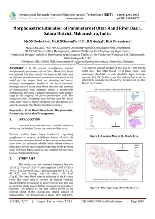
  • 1. International Research Journal of Engineering and Technology (IRJET) e-ISSN: 2395-0056 Volume: 05 Issue: 06 | June 2018 www.irjet.net p-ISSN: 2395-0072 © 2018, IRJET | Impact Factor value: 7.211 | ISO 9001:2008 Certified Journal | Page 2609 Morphometric Estimation of Parameters of Uttar Mand River Basin, Satara District, Maharashtra, India. Mr.S.S.Chokakkar1, Mr.G.N.ChavanPatil2, Dr.D.N.Mudgal3, Dr.A.Shreenivasa4 1M.Sc., B.Ed, NET, PhD(Pur.) (Geology)- AssistantProfessor, Civil Engineering Department, 2M.E. Civil(Construction Management) AssistantProfessor, Civil Engineering Department, 3Professor& Director, Ashokrao Mane Group of Institutions, Vathar ,At Po. Vathar tarf Vadgoan, Tal Hatkanangle, Dist: Kolhapur416112 4.Professor MSc., M.Phil, PhD Department of studies in Geology Karnataka University, Dharwad. ---------------------------------------------------------------------***--------------------------------------------------------------------- ABSTRACT : In the present investigation various morphometric parameters of the Uttar Mand river basin are outlined. The Uttar Mand river basin is 5th order and its different morphometrical parameters are found to be useful for the proper land use planning and water resources management studies in the basin. Dendritic drainage pattern in the area shows that the area consists of homogeneous rock material, which is structurally undisturbed. The Basin is passing through an early mature stage to old stage of the fluvial geomorphic cycle. The elongation and circulatory ratio reveals that the Uttar Mand river basin is highly elongated and flood flows are easier to manage than that of circulatory basins. Keywords - Uttar Mand River Basin, Morphometric, Parameters, Watershed Management 1. INTRODUCTION Land and water are two most feasible resources which are the basis of lIfe on the surface of the earth. Various studies have been conducted regarding morphometric analysis in different basins of India. At this moment computer based analysis are proving easier, time- effectual and most reliable results where software plays great role in analysing the huge data. In the present study software based analysis was carried out that was later verified in field study. 2. STUDY AREA The study area lies between between latitude 17020’12’’N to 17025’24’’N and longitude 73055’07’’E to 7405’7’’E in Survey of India Toposheet numbers 47 G/15, 47 K/3 and having area of about 109 km2 (Fig. 1). The Uttar Mand river is tributary of the Krishna river. The study area is covered by Deccan volcanic basalt of Upper Cretaceous to Lower Eocene age. The soil layer of the study area is fertile and used for agriculture purpose. The climate of the area comes across as an comical blend of the coastal and inland climate of Maharashtra. The temperature is about 10°C and 40°C. The average annual rainfall of the area is 1000 mm. to 2500 mm. The Uttar Mand river basin shows well developed dendritic to sub dendritic type drainage pattern. (Fig. 2). In this paper the authors had made an attempt to evaluate morphometric Parameters of Uttar Mand river basin. Figure 1 : Location Map of the Study Area Figure 2 : Drainage map of the Study area
  • 2. International Research Journal of Engineering and Technology (IRJET) e-ISSN: 2395-0056 Volume: 05 Issue: 06 | June 2018 www.irjet.net p-ISSN: 2395-0072 © 2018, IRJET | Impact Factor value: 7.211 | ISO 9001:2008 Certified Journal | Page 2610 3. METHODOLOGY The stream networks were previously digitised using toposheet and satellite imagery of the respected area using Arc GIS software. The Survey of India Toposheet numbers 47 G/15, 47 K/3 on the scale of 1 : 50,000 were used for the study. Stream ordering method as suggested by the Strahler has been employed. The calculation was operated using mathematical equations and different required parameters were calculated, by using formulae. For stream ordering method suggested by Strahler (1957) has been used. 4. RESULTS AND DISCUSSION The digitisation of the basin has been done and various parameters of morphometry were calculated under major heads of linear, areal and relief aspects. 4.1. LINEAR MORPHOMETRIC ASPECTS 4.1.1. Stream Order (u) The first step towards drainage basin analysis is the designation of stream order which shows the relative and hierarchical relationship between stream segments, their connectivity and the discharge having contributions of the basin. Stream order of drainage basin is the successive assimilation of the streams within a drainage basin. The ordering of the basin have been carried out by the method suggested by Strahler (1957). The Uttar Mand river basin is 5th Orders. (Table 1) 4.1.2. Stream Number (Nu) Horton2 stated that the numbers of stream segments of each order eventually form an inverse geometric sequence with the order number. The total number of streams in the study area is 533 as mentioned above. out of that 76.36% are the first order streams having 407 segments. The second order stream segments are 99 and account for 18.6%, third order stream segments are 22 and accounted 4.12%, fourth order stream segments are 4 and account for 0.75% and fifth order stream segment is 1 and account for 0.18%. The logarithm of stream length of each order as a function of order is plotted and yields a set of points lying generally along a straight line. Relation between stream order (u) and stream number (Nu) show the straight line which indicate area without structural disturbance (Fig. 4). Figure 3: Relation between Stream Order (u) and Stream Numbers (Nu) 4.1.3 Bifurcation Ratio (Rb) The bifurcation ratio can be defined as a ratio of the number of stream segments of given order to the number of segments of next higher order. It is the ratio of number and streams and any given order to the number streams in the text lower order (Horton, 1945). 1   Nu Rb Nu The significance of this ratio is that as the ratio is reduced so the risk and flooding within the basin increases. It also indicates the flood risk for parts and the basin. In the Uttar Mand river basin bifurcation ratio ranges from 4.11 to 4. The mean bifurcation ratio for Uttar Mand river basin is 4.52. This means that on average there are 4.52 times as many channel segments to any given order as of the next higher order. The average bifurcation ratio and the basin reveals that there appears to be no strong geological control in the development and the drainage, homogeneous nature of Lithology and drainage network in study area as well developed stage (Table 1). 4.1.4 Stream Length (Lu) The stream network of Uttar Mand river basin was previously categorized into several orders, which were then computed using Arc GIS software using Survey of India toposheets as primary data.Study of the streams length with respect to the stream order is of significant importance. Stream length for the basin and the given order is inversely proportional to the stream order. Stream length of the basin indicates surface runoff characteristics. Stream are relatively smaller lengths and characteristics and area with greater slopes. Stream length of Uttar Mand river basin is measured with the help of rotometer. The total stream length in Uttar Mand river basin is 383.62 km (Table 1). The mean length of channel Lu and order U is the ratio of the total length to the number of streams of a given order. Mean length of channel segments of a given order is greater than that of the next lower order but less than that of the
  • 3. International Research Journal of Engineering and Technology (IRJET) e-ISSN: 2395-0056 Volume: 05 Issue: 06 | June 2018 www.irjet.net p-ISSN: 2395-0072 © 2018, IRJET | Impact Factor value: 7.211 | ISO 9001:2008 Certified Journal | Page 2611 next higher order. The logarithm and stream length of each order as a function of order is plotted (Fig.) and relation between stream order (u) and mean stream length (Fig.) yields a set of points lying generally along a straight line, that indicates no strong structural control in the area (Geena, 2011). Figure 4 : Relation between Stream Order (u) and Mean Stream Length (Nu) 4.1.5. Stream Length Ratio (Rl) The ratio in between the average lengths of successive orders is stream length ratio (Horton, 1945). In the southern half part of basin large number of small streams is developed where the formations at upstream side and are less permeable (Manu, 2008). Stream length ratio of Uttar Mand river basin is given in Table 1. 4.2. AERIAL ASPECTS OF DRAINAGE BASIN 4.2.1. Basin Area (A) The area of Uttar Mand river basin is about 109.85 sq. km. which indicates that rainwater will reach the main channel more rapidly, where the water has much further to travel. 4.2.2. Drainage Density (Dd) The drainage density has been found to be an important parameter which can be defined as total length of the streams of all orders/drainage area. Drainage density is defined as a ratio of total length of all streams to the total area of the basin. (Horton, 1932).  Lu Dd A Drainage density of the any basin reveals the terrain configuration that is properties of rock of the area. In the study area southern half part of basin shows high drainage density which indicates region having non resistant or impermeable subsurface material and mountainous relief, whereas northern half part of basin shows low drainage density which indicates region having highly resistant rock or highly permeable subsoil material and area with low relief. (Geena, 2011). The overall drainage density (Dd) of the Uttar Mand river basin is 3.49 km/sq.km (Table 2) 4.2.3. Stream Frequency (Fs) The stream frequency of the basin is the ratio of total number of stream segments of all orders to the basin area. (Horton, 1945)  Nu Fs A The stream frequency found in the study area shows a positive correlation with its calculated drainage density, indicating an increase in the stream population with the increase in drainage density. It is a good indicator of drainage pattern. Stream frequency has been calculated by the number of streams divided by the total area of basin in sq. km. The stream frequency of the Uttar Mand river basin is found to be 4.85. High drainage density and high stream frequency in Uttar Mand river basin indicate larger runoff from the basin. (Table 2) 4.2.4. Constant of Channel Maintenance (C) The Constant of Channel Maintenance is the inverse of the drainage density. (Schumm, 1956). Therefore higher the drainage density lowers the constant of channel maintenance and vice versa. In the southern half part of the basin the value of Constant of channel maintenance is very low which indicate that only rocks are relatively impermeable or terrain is very steep. But in the northern half part of the basin the value of Constant of channel maintenance is relatively high which indicate the presence of little more permeable overlying material than southern part of the basin. Regarding the Uttar Mand river basin, the average constant of channel maintenance is 0.28 ( Table 2 ) 4.2.5. Texture Ratio (Rt) It is the ratio of total stream numbers to the total perimeter of the basin (Horton, 1945).  Nu Rt P Texture ratio is an important factor in the drainage morphometric analysis which is depending up on the underlying lithology, infiltration capacity and relief aspect of the terrain (Nageswara, 2010). Smith (1950) has classified drainage density into five different texture i.e. very coarse (<2), Coarse (2-4), moderate (4- 6), fine (6-8) and very fine (>8). In the present study texture ratio of the Uttar Mand river basin is 6.95, which 0 5 10 15 20 1 2 3 4 5 MeanStreamLength (Nu) Stream Order (u)
  • 4. International Research Journal of Engineering and Technology (IRJET) e-ISSN: 2395-0056 Volume: 05 Issue: 06 | June 2018 www.irjet.net p-ISSN: 2395-0072 © 2018, IRJET | Impact Factor value: 7.211 | ISO 9001:2008 Certified Journal | Page 2612 indicate fine texture and area under high relief and steep slopes. (Table 2) Table 1. Linear aspects of the drainage network of the study area. 4.2.6. Elongation Ratio (Re) Elongation ratio is defined as the ratio of diameter of a circle of the same area as the basin to the maximum basin length (Schumm, 1956). 2 Re  A Lb  It is the very significant index in the analysis of basin shape which helps to give an idea about hydrological characters of a drainage basin. The value of elongation ratio (Re) generally varies from 0.6 to 1.0 associated with a wide variety of climate and geology. Values close to 1.0 are typical of regions of very low relief whereas that of 0.6 to 0.8 are associated with high relief and steep ground slope (Strahler, 1964). These values can be grouped into three categories, namely circular (>0.9), oval (09-0.8) and elongated (< 0.7).The Elongation ratio of the Uttar Mand river basin is 0.59 which indicate basin is highly elongated. (Table 2) 4.2.7. Circulatory Ratio (Rc) Circulatory ratio is the ratio of basin area to the area of circle having the same perimeter as the basin (Miller, 1953). 2 4  A Rc P  It is influenced more by the length, frequency and gradient of streams of various orders than slope conditions and drainage pattern of the basins (Strahler, 1957). Circulatory ratio of Uttar Mand river basin is 0.40 which is below 0.5 and shows strongly elongated basin with semi permeable homogeneous lithology. (Table 2) 4.2.8. Form Factor Ratio (Rf) Form Factor Ratio is the dimensionless ratio of the basin area to the square of basin length (Horton, 1932). 2  A Rf Lb The Form Factor Ratio value of the Uttar Mand river basin is 0.28which is very nearer to zero and thus represents highly elongated in shape. In this elongated basin with low form factor will have a flatter peak flow of longer duration. Flood flows in elongated basins are easier to manage than that of the circular basins (Geena, 2011). (Table 2) Table 2. Aerial Aspects of the drainage network of the study area. River Basin Stream Order (u) Number of Streams (Nu) Total length of streams in km (Lu) Mean Stream Lengths Uttar Mand 1 407 239.106 0.58 2 99 85.201 0.86 3 22 31.734 1.44 4 04 12.534 3.13 5 01 15.049 15.04 Total 533 383.62 Bifurcation Ratio (Rb) Mean Bifurcation Ratio 1st Order / 2nd Order 2nd Order / 3rd Order 3rd Order / 4th Order 4th Order / 5th Order 4.11 4.5 5.5 4 4.52
  • 5. International Research Journal of Engineering and Technology (IRJET) e-ISSN: 2395-0056 Volume: 05 Issue: 06 | June 2018 www.irjet.net p-ISSN: 2395-0072 © 2018, IRJET | Impact Factor value: 7.211 | ISO 9001:2008 Certified Journal | Page 2613 Where, Lu = Total Stream length of all orders. Nu = Total number of streams of all orders N1 = Total number of 1st order streams. Π = 3.14 5. CONCLUSION The morphometric study of Uttar Mand river indicates that the basin is fifth order basin and is passing through an early mature stage to old stage of the fluvial geomorphic cycle. The basin shows dendritic type drainage pattern. Mean length of channel segments of a given order is greater than that of the next lower order but less than that of the next higher order. The relation between stream order and mean stream length, yields a set of points lying generally along a curve line, that indicates no strong structural control in the area. The average bifurcation ratio of the basin reveals that there appears to be no strong geological control in the development of the drainage, homogeneous nature of lithology and drainage network in study area is well developed stage. The southern half part of the basin is under high relief which shows steep slopes with high drainage density, high stream frequency, low constant of channel maintenance and less permeable subsurface lithology. The northern half part of the basin is under low relief as compare to the southern part which shows gentle slopes with low drainage density, low stream frequency, high constant of channel maintenance and highly permeable subsurface lithology. The elongation ratio, circulatory ratio and form factor reveals that the Uttar Mand river basin is highly elongated and flood flows are easier to manage than that of circulatory basins. The study also reveals that the texture of Uttar Mand river basin is very fine and basin is highly elongated. The drainage basin size analysis reveals that the flooding is lesser. 6. ACKNOWLEDGEMENTS The authors are very much thankful to Management and Director of A.M.G.O.I, Vathar, Dist- Kolhapur for their constant encouragement and support. REFERENCES Journal Papers: 1. Geena G. B. and Ballukraya P. N., Morphometric analysis of Korattalaiyar River Basin, Tamil Nadu, India : A GIS approach, Int. Jou. of Geomatics and Geoscience, Vol. 2, No. 2, 2011, 383 – 391. 2. Thakur, B.R. (2006), Quant i tat ive Analysis of Solani Watershed Using Remote Sensing and GIS Techniques, Punjab Geographer, Vol . 1, No. 2, PP. 85-98 3. Horton K. G. Smith, Standard for grading texture of erosional topography, Ame. J. Soc., 5 (298) 1950, 655-668. 4. Schumm S. A., The relation of drainage basin relief to sediment loss, Pub. International Association of Hydrology, IUGG, Tenth Gen. Assembly, Rome, 1, 1954, 216-219. 5. Singh, Savindra (2002), Geomorphology, Prayag Pustak Bhawan, Al lahabad. Books : 1. Parbin Singh. Principles of Engineering Geology. 2. Robart B. Johnsan. Principles of Engineering Geology. 3. K.M.Banger Principles of Engineering Geology.