Submit Search
Upload
IRJET-Morphometric Analysis of Vela Hari Watershed using GIS
•
0 likes
•
47 views
IRJET Journal
Follow
https://irjet.net/archives/V5/i6/IRJET-V5I6180.pdf
Read less
Read more
Engineering
Report
Share
Report
Share
1 of 4
Download now
Download to read offline
Recommended
IRJET- Morphometric Estimation of Parameters of Uttar Mand River Basin, Sata...
IRJET Journal
Streamflow simulation using radar-based precipitation applied to the Illinois...
Alireza Safari
Morphometric analysis of a vrishabhavathi sub watershed upstream side of gali...
eSAT Publishing House
Geomorphological Analysis of Two Mini-Watersheds in Raichur City Karnataka
Mohammed Badiuddin Parvez
MORPHOMETRIC ANALYSIS OF SUKE SUB-WATERSHED OF TAWA RESERVOIR CATCHMENT AREA ...
Journal For Research
Ijirt148631 paper (1)
Mohammed Badiuddin Parvez
IRJET- Morphometric Analysis of Venna River Basin using Geospatial Tool
IRJET Journal
Suspended Sediment Rating Curve for Tigris River Upstream Al- Betera Regulator
IJRES Journal
04 mb.v.h
04 mb.v.h
madhusudan386939
75 76
75 76
INTERNATIONAL INDEXED,REFERRED,MULTILINGUAL,INTERDISCIPLINARY, MONTHLY RESEARCH JOURNAL
Morphometric Analysis of Markandeya River Sub Basin (MRSB), Belgaum District,...
IJERD Editor
Groundwater Prospectus Map for Suryanagar Subwatershed
Mohammed Badiuddin Parvez
A New Approximation of Water Saturation Estimation Based on Vertical Seismic ...
IJERA Editor
6 ijsrms-02616 (1)
6 ijsrms-02616 (1)
Mohammed Badiuddin Parvez
IRJET- Quantitative Morphometric Analysis of Panchganga Basin using GIS
IRJET Journal
Evaluation of morphometric parameters derived from Cartosat-1 DEM using remot...
Dr Ramesh Dikpal
Suspended Sediment Measurement on the Rivers Bandon and Owenabue, Ireland
Environmental Protection Agency, Ireland
Evaluation of Morphometric Parameters Derived from CartoDEM and Aster GDEM wi...
Dr Ramesh Dikpal
DEEP PERCOLATION CHARACTERTISTICS VIA SOIL MOISTURE SENSOR APPROACH IN SAIGON...
IAEME Publication
X4201155161
X4201155161
IJERA Editor
28. vinay raikwar and pramod pagare
Journal of Global Resources
Sediment Yield Studies For Selected Catchments in Visakhapatnam District, And...
IJERA Editor
Enumeration and validation of hydrodynamic characteristics over plane and se
IAEME Publication
Groundwater Quality Modelling using Coupled Galerkin Finite Element and Modif...
AM Publications
Recovery Period of Fluvial Sediment Transport after a Major Earthquake_Crimso...
Advancements in Civil Engineering & Technology (ACET)
flow_through_linear_weir in analysis of the
huamrajak
IRJET- GIS based Quantitative Morphometric Analysis of Warna Watershed, Mahar...
IRJET Journal
Morphometric Analysis of Warana Basin using GIS and Remote Sensing Techniques
IRJET Journal
IRJET- Geomorphological Analysis of Two Mini-Watersheds in Raichur City K...
IRJET Journal
IRJET- Morphometric Analysis of Sina Basin Using GIS and Remote Sensing Techn...
IRJET Journal
More Related Content
What's hot
04 mb.v.h
04 mb.v.h
madhusudan386939
75 76
75 76
INTERNATIONAL INDEXED,REFERRED,MULTILINGUAL,INTERDISCIPLINARY, MONTHLY RESEARCH JOURNAL
Morphometric Analysis of Markandeya River Sub Basin (MRSB), Belgaum District,...
IJERD Editor
Groundwater Prospectus Map for Suryanagar Subwatershed
Mohammed Badiuddin Parvez
A New Approximation of Water Saturation Estimation Based on Vertical Seismic ...
IJERA Editor
6 ijsrms-02616 (1)
6 ijsrms-02616 (1)
Mohammed Badiuddin Parvez
IRJET- Quantitative Morphometric Analysis of Panchganga Basin using GIS
IRJET Journal
Evaluation of morphometric parameters derived from Cartosat-1 DEM using remot...
Dr Ramesh Dikpal
Suspended Sediment Measurement on the Rivers Bandon and Owenabue, Ireland
Environmental Protection Agency, Ireland
Evaluation of Morphometric Parameters Derived from CartoDEM and Aster GDEM wi...
Dr Ramesh Dikpal
DEEP PERCOLATION CHARACTERTISTICS VIA SOIL MOISTURE SENSOR APPROACH IN SAIGON...
IAEME Publication
X4201155161
X4201155161
IJERA Editor
28. vinay raikwar and pramod pagare
Journal of Global Resources
Sediment Yield Studies For Selected Catchments in Visakhapatnam District, And...
IJERA Editor
Enumeration and validation of hydrodynamic characteristics over plane and se
IAEME Publication
Groundwater Quality Modelling using Coupled Galerkin Finite Element and Modif...
AM Publications
Recovery Period of Fluvial Sediment Transport after a Major Earthquake_Crimso...
Advancements in Civil Engineering & Technology (ACET)
flow_through_linear_weir in analysis of the
huamrajak
What's hot
(18)
04 mb.v.h
04 mb.v.h
75 76
75 76
Morphometric Analysis of Markandeya River Sub Basin (MRSB), Belgaum District,...
Groundwater Prospectus Map for Suryanagar Subwatershed
A New Approximation of Water Saturation Estimation Based on Vertical Seismic ...
6 ijsrms-02616 (1)
6 ijsrms-02616 (1)
IRJET- Quantitative Morphometric Analysis of Panchganga Basin using GIS
Evaluation of morphometric parameters derived from Cartosat-1 DEM using remot...
Suspended Sediment Measurement on the Rivers Bandon and Owenabue, Ireland
Evaluation of Morphometric Parameters Derived from CartoDEM and Aster GDEM wi...
DEEP PERCOLATION CHARACTERTISTICS VIA SOIL MOISTURE SENSOR APPROACH IN SAIGON...
X4201155161
X4201155161
28. vinay raikwar and pramod pagare
Sediment Yield Studies For Selected Catchments in Visakhapatnam District, And...
Enumeration and validation of hydrodynamic characteristics over plane and se
Groundwater Quality Modelling using Coupled Galerkin Finite Element and Modif...
Recovery Period of Fluvial Sediment Transport after a Major Earthquake_Crimso...
flow_through_linear_weir in analysis of the
Similar to IRJET-Morphometric Analysis of Vela Hari Watershed using GIS
IRJET- GIS based Quantitative Morphometric Analysis of Warna Watershed, Mahar...
IRJET Journal
Morphometric Analysis of Warana Basin using GIS and Remote Sensing Techniques
IRJET Journal
IRJET- Geomorphological Analysis of Two Mini-Watersheds in Raichur City K...
IRJET Journal
IRJET- Morphometric Analysis of Sina Basin Using GIS and Remote Sensing Techn...
IRJET Journal
IRJET - Quantitative Morphometric Analysis of Adhala Basin, Ahmednagar Mahara...
IRJET Journal
Morphometric Analysis of Indrayani River Basin using Remote Sensing and GIS T...
IRJET Journal
IRJET- Quantitative Morphometric Analysis of a Manganga Basin, Maharashtr...
IRJET Journal
Remote sensing and GIS in the morphometric analysis of macro-watersheds for h...
IRJET Journal
IRJET- A Review of Synthetic Hydrograph Methods for Design Storm
IRJET Journal
Prioritization Of Subwatersheds of Cauvery Region Based on Morphometric Analy...
Mohammed Badiuddin Parvez
Quantitative evaluation and analysis of morphometric parameters derived from ...
AM Publications
Morphometric Studies of Fourth order Sub-Basins (FOSB’s) in North Bangalore M...
Dr Ramesh Dikpal
Morphometry hypsometry_analysis_and_runoff_estimation_of_aam_talab_watershed...
Mohammed Badiuddin Parvez
Monitoring NDTI-River Temperature relationship along the river ganga in the s...
IRJET Journal
WATERSHED PRIORITIZATION IN RELATION TO SOIL EROSION USING GEOSPATIAL TECHNIQ...
IRJET Journal
Statistical Model to Analyze the Impact of Land use Activity for District Lud...
IRJET Journal
Estimation of morphometric parameters and
eSAT Publishing House
Estimation of morphometric parameters and runoff using rs & gis techniques
eSAT Journals
Estimation of morphometric parameters and runoff using rs & gis techniques
eSAT Journals
Open channel flow velocity profiles for different reynolds numbers and roughn...
eSAT Journals
Similar to IRJET-Morphometric Analysis of Vela Hari Watershed using GIS
(20)
IRJET- GIS based Quantitative Morphometric Analysis of Warna Watershed, Mahar...
Morphometric Analysis of Warana Basin using GIS and Remote Sensing Techniques
IRJET- Geomorphological Analysis of Two Mini-Watersheds in Raichur City K...
IRJET- Morphometric Analysis of Sina Basin Using GIS and Remote Sensing Techn...
IRJET - Quantitative Morphometric Analysis of Adhala Basin, Ahmednagar Mahara...
Morphometric Analysis of Indrayani River Basin using Remote Sensing and GIS T...
IRJET- Quantitative Morphometric Analysis of a Manganga Basin, Maharashtr...
Remote sensing and GIS in the morphometric analysis of macro-watersheds for h...
IRJET- A Review of Synthetic Hydrograph Methods for Design Storm
Prioritization Of Subwatersheds of Cauvery Region Based on Morphometric Analy...
Quantitative evaluation and analysis of morphometric parameters derived from ...
Morphometric Studies of Fourth order Sub-Basins (FOSB’s) in North Bangalore M...
Morphometry hypsometry_analysis_and_runoff_estimation_of_aam_talab_watershed...
Monitoring NDTI-River Temperature relationship along the river ganga in the s...
WATERSHED PRIORITIZATION IN RELATION TO SOIL EROSION USING GEOSPATIAL TECHNIQ...
Statistical Model to Analyze the Impact of Land use Activity for District Lud...
Estimation of morphometric parameters and
Estimation of morphometric parameters and runoff using rs & gis techniques
Open channel flow velocity profiles for different reynolds numbers and roughn...
More from IRJET Journal
TUNNELING IN HIMALAYAS WITH NATM METHOD: A SPECIAL REFERENCES TO SUNGAL TUNNE...
IRJET Journal
STUDY THE EFFECT OF RESPONSE REDUCTION FACTOR ON RC FRAMED STRUCTURE
IRJET Journal
A COMPARATIVE ANALYSIS OF RCC ELEMENT OF SLAB WITH STARK STEEL (HYSD STEEL) A...
IRJET Journal
Effect of Camber and Angles of Attack on Airfoil Characteristics
IRJET Journal
A Review on the Progress and Challenges of Aluminum-Based Metal Matrix Compos...
IRJET Journal
Dynamic Urban Transit Optimization: A Graph Neural Network Approach for Real-...
IRJET Journal
Structural Analysis and Design of Multi-Storey Symmetric and Asymmetric Shape...
IRJET Journal
A Review of “Seismic Response of RC Structures Having Plan and Vertical Irreg...
IRJET Journal
A REVIEW ON MACHINE LEARNING IN ADAS
IRJET Journal
Long Term Trend Analysis of Precipitation and Temperature for Asosa district,...
IRJET Journal
P.E.B. Framed Structure Design and Analysis Using STAAD Pro
IRJET Journal
A Review on Innovative Fiber Integration for Enhanced Reinforcement of Concre...
IRJET Journal
Survey Paper on Cloud-Based Secured Healthcare System
IRJET Journal
Review on studies and research on widening of existing concrete bridges
IRJET Journal
React based fullstack edtech web application
IRJET Journal
A Comprehensive Review of Integrating IoT and Blockchain Technologies in the ...
IRJET Journal
A REVIEW ON THE PERFORMANCE OF COCONUT FIBRE REINFORCED CONCRETE.
IRJET Journal
Optimizing Business Management Process Workflows: The Dynamic Influence of Mi...
IRJET Journal
Multistoried and Multi Bay Steel Building Frame by using Seismic Design
IRJET Journal
Cost Optimization of Construction Using Plastic Waste as a Sustainable Constr...
IRJET Journal
More from IRJET Journal
(20)
TUNNELING IN HIMALAYAS WITH NATM METHOD: A SPECIAL REFERENCES TO SUNGAL TUNNE...
STUDY THE EFFECT OF RESPONSE REDUCTION FACTOR ON RC FRAMED STRUCTURE
A COMPARATIVE ANALYSIS OF RCC ELEMENT OF SLAB WITH STARK STEEL (HYSD STEEL) A...
Effect of Camber and Angles of Attack on Airfoil Characteristics
A Review on the Progress and Challenges of Aluminum-Based Metal Matrix Compos...
Dynamic Urban Transit Optimization: A Graph Neural Network Approach for Real-...
Structural Analysis and Design of Multi-Storey Symmetric and Asymmetric Shape...
A Review of “Seismic Response of RC Structures Having Plan and Vertical Irreg...
A REVIEW ON MACHINE LEARNING IN ADAS
Long Term Trend Analysis of Precipitation and Temperature for Asosa district,...
P.E.B. Framed Structure Design and Analysis Using STAAD Pro
A Review on Innovative Fiber Integration for Enhanced Reinforcement of Concre...
Survey Paper on Cloud-Based Secured Healthcare System
Review on studies and research on widening of existing concrete bridges
React based fullstack edtech web application
A Comprehensive Review of Integrating IoT and Blockchain Technologies in the ...
A REVIEW ON THE PERFORMANCE OF COCONUT FIBRE REINFORCED CONCRETE.
Optimizing Business Management Process Workflows: The Dynamic Influence of Mi...
Multistoried and Multi Bay Steel Building Frame by using Seismic Design
Cost Optimization of Construction Using Plastic Waste as a Sustainable Constr...
Recently uploaded
Porous Ceramics seminar and technical writing
rakeshbaidya232001
Microscopic Analysis of Ceramic Materials.pptx
purnimasatapathy1234
Model Call Girl in Narela Delhi reach out to us at 🔝8264348440🔝
soniya singh
Extrusion Processes and Their Limitations
120cr0395
UNIT-V FMM.HYDRAULIC TURBINE - Construction and working
rknatarajan
The Most Attractive Pune Call Girls Budhwar Peth 8250192130 Will You Miss Thi...
ranjana rawat
Call for Papers - African Journal of Biological Sciences, E-ISSN: 2663-2187, ...
Christo Ananth
High Profile Call Girls Nagpur Isha Call 7001035870 Meet With Nagpur Escorts
ranjana rawat
Top Rated Pune Call Girls Budhwar Peth ⟟ 6297143586 ⟟ Call Me For Genuine Se...
Call Girls in Nagpur High Profile
(ANJALI) Dange Chowk Call Girls Just Call 7001035870 [ Cash on Delivery ] Pun...
ranjana rawat
HARMONY IN THE NATURE AND EXISTENCE - Unit-IV
RajaP95
(RIA) Call Girls Bhosari ( 7001035870 ) HI-Fi Pune Escorts Service
ranjana rawat
Call Us -/9953056974- Call Girls In Vikaspuri-/- Delhi NCR
9953056974 Low Rate Call Girls In Saket, Delhi NCR
Booking open Available Pune Call Girls Koregaon Park 6297143586 Call Hot Ind...
Call Girls in Nagpur High Profile
Structural Analysis and Design of Foundations: A Comprehensive Handbook for S...
Dr.Costas Sachpazis
IMPLICATIONS OF THE ABOVE HOLISTIC UNDERSTANDING OF HARMONY ON PROFESSIONAL E...
RajaP95
Call Girls in Nagpur Suman Call 7001035870 Meet With Nagpur Escorts
Call Girls in Nagpur High Profile
(SHREYA) Chakan Call Girls Just Call 7001035870 [ Cash on Delivery ] Pune Esc...
ranjana rawat
OSVC_Meta-Data based Simulation Automation to overcome Verification Challenge...
Soham Mondal
247267395-1-Symmetric-and-distributed-shared-memory-architectures-ppt (1).ppt
ssuser5c9d4b1
Recently uploaded
(20)
Porous Ceramics seminar and technical writing
Microscopic Analysis of Ceramic Materials.pptx
Model Call Girl in Narela Delhi reach out to us at 🔝8264348440🔝
Extrusion Processes and Their Limitations
UNIT-V FMM.HYDRAULIC TURBINE - Construction and working
The Most Attractive Pune Call Girls Budhwar Peth 8250192130 Will You Miss Thi...
Call for Papers - African Journal of Biological Sciences, E-ISSN: 2663-2187, ...
High Profile Call Girls Nagpur Isha Call 7001035870 Meet With Nagpur Escorts
Top Rated Pune Call Girls Budhwar Peth ⟟ 6297143586 ⟟ Call Me For Genuine Se...
(ANJALI) Dange Chowk Call Girls Just Call 7001035870 [ Cash on Delivery ] Pun...
HARMONY IN THE NATURE AND EXISTENCE - Unit-IV
(RIA) Call Girls Bhosari ( 7001035870 ) HI-Fi Pune Escorts Service
Call Us -/9953056974- Call Girls In Vikaspuri-/- Delhi NCR
Booking open Available Pune Call Girls Koregaon Park 6297143586 Call Hot Ind...
Structural Analysis and Design of Foundations: A Comprehensive Handbook for S...
IMPLICATIONS OF THE ABOVE HOLISTIC UNDERSTANDING OF HARMONY ON PROFESSIONAL E...
Call Girls in Nagpur Suman Call 7001035870 Meet With Nagpur Escorts
(SHREYA) Chakan Call Girls Just Call 7001035870 [ Cash on Delivery ] Pune Esc...
OSVC_Meta-Data based Simulation Automation to overcome Verification Challenge...
247267395-1-Symmetric-and-distributed-shared-memory-architectures-ppt (1).ppt
IRJET-Morphometric Analysis of Vela Hari Watershed using GIS
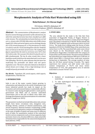
1.
International Research Journal
of Engineering and Technology (IRJET) e-ISSN: 2395-0056 Volume: 05 Issue: 06 | June-2018 www.irjet.net p-ISSN: 2395-0072 © 2018, IRJET | Impact Factor value: 6.171 | ISO 9001:2008 Certified Journal | Page 957 Morphometric Analysis of Vela Hari Watershed using GIS Mohd Rehman1, Dr.Vikram Singh2 1PG Scholar, SHUATS, Allahabad, UP 2Associate Professor, SHUATS, Allahabad, UP ---------------------------------------------------------------------***--------------------------------------------------------------------- Abstract - The summarization of Morphometric analysis based on several drainage parameters of the selected area, by which the watershed streams have been classified up to fifth order streams. The calculated facet of watershed was carried out i.e., stream order (529.00), bifurcationratio(4.80), stream length (431.1Km) and aerial aspects such as drainage density (Dd =2.25), stream frequency (Fs =2.76), form factor (Ff =0.02), circulatory ratio (Rc =0.25) and elongationratio(Re=0.60)has been carried out on the basis of soil erosion. The readingof the figures exposed that the total no of streams were 529 in that 412 in first order, 94 in second, 18 in third 4 in fourth and 1 in fifth simultaneously. The low Rb value reveals that a lower peak flow would result from the watershed and it can be more risk of flooding. The low Dd value indicates that the basin has moderately low permeable soil (black soil) and sparse vegetative cover. The low Rc value also indicatesasthebasinis almost drawn out in shape, it has a high discharge rate of runoff and poorly permeable soil condition. Key Words: Toposheet, GIS, aerial aspects, relief aspects, morphometric, Vela Hari etc. 1. INTRODUCTION India is one of the major country fastest growing in urbanization and industries in the world. Urbanization and heavy industrial growth has made its impact on the ecosystem and environment balance is potentially affected. To conserve water during drought period is a main goal by government and NGOs and to increase watershed conservation and to this lots of efforts were taken into drainage development and characterizationsofa watershed. (Ashok S. Sangle et al. 2015). The parameters workedoutincludebifurcationratio,stream length, form factor, circulatory ratio, elongation ratio, drainage density, constant of channel maintenance, and stream frequency. National Institute of Hydrology (1998) has carried out morphometric analysis of Suddagedda basin in the state of Andhra Pradesh and many more in different parts of India. For quantitative analysis of the watershed involve various components such as stream segments,basin perimeter, basin area, elevation difference, slope andprofile of land has been responsible for the natural development of basin (Horton, 1945) 2. STUDY AREA The area selected for the study is the Vela Hari from watershed of Nagpur(R) Taluka of Nagpur District in Maharashtra State the location is 15 km away from Nagpur main. The taluka is situated at 21°00′58′′ NorthLatitudeand 78°00′58′′ East Longitude with an Elevation above sea level 314 m. The study area is falling under the Survey of India toposheet of 55 O/4 (1:50,000) Slope of the watershed area varies from 1 to 5%. The watershed falls under semi critical zone Based on the Thornthwaite system of climatic classification, Nagpur(R) is classified under the category of Tropical Dry-sub-humid climate.The meanannual rainfall of the watershed area ranges between 900 mm to 1100 mm, of which about 80% is received from south-west monsoon during June to September. The average numbers of rainy days are 68 those spread during 4 months. The region experiences hot summer and mild winter with mean summer temperature of 44.2°C and mean winter temperature of 7.6°C. The geographical area of selected watershed is around 192 km2 area. Objectives 1. Analysis of morphological parameters of a watershed, 2. To infer hydrological characterizations of the watershed area. Fig-1 Location of study area
2.
International Research Journal
of Engineering and Technology (IRJET) e-ISSN: 2395-0056 Volume: 05 Issue: 06 | June-2018 www.irjet.net p-ISSN: 2395-0072 © 2018, IRJET | Impact Factor value: 6.171 | ISO 9001:2008 Certified Journal | Page 958 3. MATERIALS AND METHODS Computation of the basic parameters (i.e. area, perimeter, stream order, stream length, stream number and elevation) of the watershed analyses by using the GIS approach. Finally bifurcation ratio (Rb), drainage density (Dd), stream frequency (Fs), texture ratio (RT), form factor (Ff), circulatory ratio (Rc), elongation ratio (Re) and compactness constant (Cc). Stream Length Ratio RL : Thestreamlengthratio RL is the ratio of the mean length of the stream of a given order 1uL to the mean length of the streams of the next smaller order 1uL . 11 1 u u L L RL Bifurcation Ratio bR : The bifurcation ratio is the ratio of the number of streams in lower order uN to the next order 1uN .It is seen that the bifurcation ratio is lower in alluvial region as compare to the Himalayan zone. 1 u u b N N R Form factor fR : Form factor is defined as the ratio of basin area A to square of the maximum length of the basin bL . The smaller value of form factor, more elongated will be the watershed. The watershed with high formfactors have high peak flows of shorter duration (Horton, 1932). 2 b f L A R Elongation Ratio eR : It is calculated as the ratio of equal diameter of the circle which has same area as that of the watershed to the maximum length of the basin. Elongation ratio is denoted by eR . A L R b e 2 Circulatory Ratio cR : The circulatory ratio is influenced by the length and frequency ofstream. Thecircularity ratiois a similar measure as elongation ratio, originally defined by (Miller, 1953), as the ratio of the area of the basin to the area of the circle having equivalent circumference as the basin perimeter and it is denoted by the cR . 2 57.12 r c P A R Drainage Density dD : The unit of the drainage density is 2 /kmkm , which is indicate the proximity of channel spacing, thus provide an idea about quantitymeasuresofthe watershed (Strahler 1964). Drainage density is denoted by dD . A L D u d 4. RESULT AND DISCUSSION Stream Order: The term "stream orders" is the primary step of morphometric analysis. Which is based on the delineated streams and their branching proposed by (Strahler, 1964). From the Table 1 found that watershed designed as Fifth order. Bifurcation ratio is depending onstreamorderaswell as number of streams. Total number of streams and stream length of all order is 529 and 431.1 km respectively. Stream Length: The values of length (Lu) and total stream length are shown in Table 1. According to Horton's second law (1945) the stream length characteristics of the sub-basins validates the "laws of stream length". Which statesthattheaveragelength of streams of each of the different orders in a drainage basin tends closely to approximate a direct geometric ratio (Horton, 1945). In general logarithms of the number of streams of a given order, when plotted against the order, the points lie on a straight line (Horton, 1945). Most drainage networks show a linear relationship with a small deviation from a straight line (Chow, 1964). Generally, the total length of stream segments decrease with stream order. Deviation from its general behavior indicate that the terrain is characterised by high relief and/or moderatelysteepslopes, underlain by varying lithology and probableupliftacrossthe basin (Singh and Singh, 1997). Bifurcation Ratio: The bifurcation ratio is of the catchment is reflect the geological as well as tectonic characteristics of the watershed (Gajbhiye et al., 2013). Lower value of Rb indicates the partially disturbed watershed without any distortion in drainage pattern (Nag, 1998). High value of Rb indicates the severe over land flow and low recharge for the sub-watershed. In this study the value of mean bifurcation ratio is 4.80 which is shown in Table 1. Drainage Density Drainage density depends upon both climate as well as physical characteristics of the drainage basins. It is a basic length scale in the landscape, is recognized to be the transition point between scales where unstable channel-
3.
International Research Journal
of Engineering and Technology (IRJET) e-ISSN: 2395-0056 Volume: 05 Issue: 06 | June-2018 www.irjet.net p-ISSN: 2395-0072 © 2018, IRJET | Impact Factor value: 6.171 | ISO 9001:2008 Certified Journal | Page 959 forming processes yield to stable diffusive processes (Tarboton et al., 1992). Drainage density is effected by various factors, among which resistance to erosion of rocks, infiltration capacity of the land and climatic conditions rank high (Verstappen, 1983). According to (Langbein,1947),the significance of drainage density as a factor which determine the time of travel by water within the basin and suggested that it varies between 0.55 to 2.89km/km2 for humid region. In this study drainage density is 2.25 and is shown in Table 1. Stream Frequency Drainage frequency or channel frequency is directly related to stream population per unit area ofthe watershed (Horton, 1932). It is indicate the close correlation with drainage density value of the sub watershed. Higher value ofdrainage frequency shows the high runoff. In this studyWS producing more runoff and value is shown in Table 1 Circulatory Ratio Circulatory ratio (Rc) influencedbythelengthandfrequency of the stream, geological structures, land use land cover (LULC), climatic variability,reliefandslopeofthewatershed. In this present study circulatory ratio is 0.25 and shown in Table 1. Form Factor Most of the researcher are suggested that the value of form factor is less than 0.7854 for perfectly circular basin (Gajbhiye et al., 2013; Rekha et al., 2011). In watershed, the smaller value of the form factor show maximum elongation of the basin. The high value of farm factorshowshighpeak in short duration and vice versa. In this study found that the value of form factor is 0.02. Elongation Ratio Generally the range of elongation ratio lies between 0.6 to 1.0 which has follow high to low relief respectively.However value categorized into three segments greater than 0.9, lie between 0.9 to 0.8 and less than 0.8 following circular, oval and elongated respectively. In this watershed elongation ratio is 0.60 where as the feature of watershedlieselongated in nature. In order to archive, watershed to be elongated and steep slope with high relief (Chopra et al., 2005; Gajbhiye et al., 2013). Texture Ratio Texture ratio is depends upon properties of lithology of the basin, infiltration of the soil and relief aspect of the terrain (Vijith and Satheesh, 2006). In the present study the texture ratio of the watershed is 5.34 and categorized as fine gravel soil. The lower values of texture ratio indicate that the basin is plain with lower degree of slopes. The value of texture ratio is shown in Table 1. Compactness Coefficient A circular basin is the most hazardous from a drainagestand point because it will yield the shortest time of concentration before peak flow occurs in the basin (Javed et al., 2009; Ratnam et al., 2005). The value of compactness coefficient was found 0.38 in watershed. Relief Ratio The values of relief ratio are given in Table 3 and is 0.01 It is noticed that the low values of Rh indicate less steepness of the basin (Vittala et al., 2004) and is an indicator of intensity of erosion process operating on the slopes of the watershed. Length of overland flow The length of overland flow (Lg) approximately equals half the reciprocal of the drainage density (Horton, 1945). This factor relates inversely to the average slope of the channel and is quite synonymous with the length of sheet flow. The value of length of overland flow in watershed is 1.12. Vela Hari Watershed Nagpur (Total area- 192 Km2) .Number of Streams (Nu) i-412,ii-94,iii-18, iv- 4.0,v-1.0 Elevation (m)- 1. Max. 302.00 2. Min. 269.00 Perimeter- 99.00 Mean Bifurcation Ratio (Rb) - 4.80 Drainage density (Dd)- 2.25 Total number of streams- 529.00 Basin length in Km (Lb)- 25.99 Stream frequency (Fs)- 2.76 Stream length in Km (Lu) i-238,ii-103.8,iii- 35.6, iv-43.3,v-10.2 Total Relief (m)- 33.00 Relief Ratio (Rh)- 0.01 Circulatory ratio (Rc)- 0.25 Form factor (Rf)- 0.02 Texture Ratio (Rt)- 5.34 Elongation Ratio (Re)- 0.60 Compactness Coefficient (Cc)- 0.38 Length of overland flow-1.12 Table-1 Shown figures is discussing about some feasible measurements such as areal, linear and relief aspects of the watershed area. Using Toposheet and some calculation we prepare the data as it shown in table.1, which having dendritic drainage pattern which can predict for nature of watershed along with low recharge problems.Wecanutilize
4.
International Research Journal
of Engineering and Technology (IRJET) e-ISSN: 2395-0056 Volume: 05 Issue: 06 | June-2018 www.irjet.net p-ISSN: 2395-0072 © 2018, IRJET | Impact Factor value: 6.171 | ISO 9001:2008 Certified Journal | Page 960 and flood can be managed by creating some obstruction and designed structure through the watershed. Fig-2 Result of Vela Hari W.S 5. CONCLUSIONS Morphometric can help in designing and adequacy of network hydrological data stations. Low Dd and Rc values indicating low permeable sub soil conditions, accompanied with the low Rb values and all the low values of Re, Rf, and Fs indicating a flater peak of flow for a longer duration thus the basin is not well capable of absorbing water into the soiland less groundwater recharging whereas more risk of flooding. If such floods would be emerged, those could be managed easily from this type of elongated basins than from circular basins by adopting suitable precautionary measures. But, synchronization with scientific accuracy and ease in data collection is still a task at micro level. REFERENCES [1]Ashok, S.S. and Pravin L.Y. (2015). Morphometric Analysis of Watershed of Sub-drainage of Godavari River in Marathwada, Ambad Region by using Remote Sensing. International Journal of Computer Applications, 125(5): 30-35. [2]Horton, R.E. (1932). Drainage-basin characteristics Transactions. American geophysical union 13: 350-361. [3]Horton, R.E. (1945). “Erosional development of streams and their drainage basins: Hydrophysical approach to quantitative morphology”. Geological Society of America Bulletin, 56: 275-370. [4]Miller, V.C. (1953). "A Quantitative Geomorphic Study of Drainage Basin Characteristics in the Clinch Mountain Area Virginia And Tennessee" DTIC Document. [5]Strahler, A.N. (1964) Handbook Of Applied Hydrology.
Download now