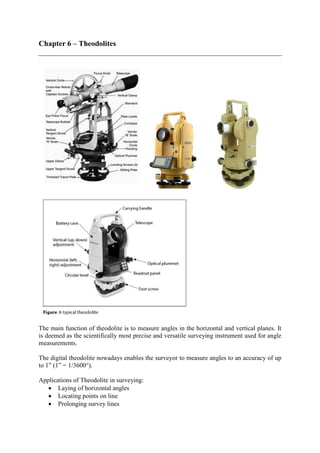
1. Chapter 6 – Theodolites
The main function of theodolite is to measure angles in the horizontal and vertical planes. It
is deemed as the scientifically most precise and versatile surveying instrument used for angle
measurements.
The digital theodolite nowadays enables the surveyor to measure angles to an accuracy of up
to 1” (1” = 1/3600°).
Applications of Theodolite in surveying:
• Laying of horizontal angles
• Locating points on line
• Prolonging survey lines
2. • Establishing grades
• Determining difference in elevation
• Setting out curves
• Aligning tunnels
A theodolite consists of a small moveable telescope that is linked with the mechanisms to
rotate vertically or horizontally. The theodolite telescope is fixed within perpendicular axes,
namely the vertical axis and the horizontal axis. The theodolite is also fixed on a base that can
be rotated on a tripod by a leveling system. Similar to the auto level, the theodolite needs to
be leveled before it is ready for taking measurements. This can be done by adjusting the foot
screw to bring the bubbles to the centre of the circular level and plate level. Also, the
theodolite needs to be aligned at the centre point of the desired station (normally marked by
the nail on a wooden peg). This can be done by moving the base of the theodolite while
observing the location of the wooden peg through the optical plummet. During measurement,
the vertical and horizontal angles will be shown on the digital readout panel. In summary, a
good setup of a theodolite must be both precisely leveled and centred.
Tacheometry
Tacheometry or tachemetry or telemetry is a branch of angular surveying in which the
horizontal and vertical distances of points are obtained by optical means, as opposed to the
ordinary slower process of measurements by tape or chain.
The method is very rapid and convenient but produces less accurate results.
It is best adopted in checking of already measured distance and preparation of topographic
maps which require both elevations and horizontal distances.
The tacheometry survey is carried out by suing the stadia diaphragm mounted in the telescope
of theodolite. The stadia diaphragm consists of one stadia hair above and the other an equal
distance below the middle horizontal cross hair.
3. The tacheometry survey can be divided into 3 methods:
1. Stadia method (or Fixed hair method)
2. Subtense method
3. Tangential method
The principal common to all the systems is to calculate the horizontal distance between two
points A and B and their distances in elevation.
Stadia method
A theodolite is set up at a survey point A, and a staff is held vertically at another survey point
B.
The readings on the staff corresponding to the all the three stadia (top, middle, bottom) are
taken. The difference of the readings corresponding to the top and bottom stadia wires will
therefore depend on the distance of the staff from the theodolite. For instance, the difference
in stadia readings (top stadia – bottom stadia) at the survey point B which is located nearer to
the theodolite should be smaller than that at survey point C, as shown in Figure below. Based
on this proportion, we can estimate the horizontal and vertical distance of any survey point
from the location of theodolite.
To apply the tacheometry survey, the data we need from the field survey includes:
i. vertical angle of the theodolite (θ)
ii. three stadia readings (top, middle, and bottom) of the leveling staff at the survey point
iii. height of the theodolite (h).
Subsequently, the horizontal and vertical distances between the survey points and the
theodolite can be calculated using the equations as follows:
4. D = K × s × cos2
(θ) + C × cos(θ)
V = (1/2) × K × s × sin(2θ) + C × sin(θ)
Where, D = horizontal distance between survey point and instrument
V = vertical distance between middle stadia and instrument
S = difference between top stadia and bottom stadia
θ = vertical angle of telescope from the horizontal line when capturing the
stadia readings
K = multiplying constant given by the manufacturer of the theodolite,
(normally = 100)
C = additive factor given by the manufacturer of the theodolite, (normally = 0)
Upon obtaining the vertical distance (V), the reduced level can be calculated at the survey
point, provided the reduced level at the point where theodolite is set up is known, as shown in
the Figure below.
RLB = RLX + h + V – r
Where RLB = reduced level at the survey point
RLA = reduced level at the station where theodolite is set up
h = height of theodolite
r = middle stadia reading
5. Example
A theodolite with a multiplying constant of 100 and 0 additive constant was set up over a
benchmark X and sighted on a leveling staff held vertically on a survey point Y. Given that
the reduced level at the benchmark X is 178.360 m, the height of the theodolite is 1.123 m,
and the three stadia readings at point Y captured through a telescope inclined slightly
downward at 2° are 2.323 m, 2.186 m, and 2.049 m, calculate
1. the horizontal distance of XY
2. the reduced level of point Y
Solution
Reduced level at Y = 176.34m
6. Example
A theodolite with a multiplying constant of 100 and 0 additive constant was set up over
benchmark A and sighted on a level staff held vertically on point B, and then on point C. The
reduced level at A is 101.238 m and the height of the theodolite from the ground is 1.298 m.
The surveying results are shown in the table below.
Calculate the difference in height between points B and C.
Solution
7. Example
A theodolite has a tacheometric constant of 100 and an additive constant of zero. The center
reading on a vertical staff held on a point B was 2.292 m when sighted from A. If the vertical
angle was + 25° and the horizontal distance AB 190.326 m, calculate the other staff readings
and thus show that the two intercept intervals are not equal. Using these values calculate the
level of B if A was 37.95 m and the height of the instrument 1.35 m.
From basic equation
CD = K × s × cos2
(θ) + C × cos(θ)
CD = 100 S cos2
θ + 0
190.326 = 100 S cos2
25°
∴ S = 2.316 m
From the figure below, HJ = S cos 25° = 2.1 m
Inclined distance CE = CD / cos 25° = 210 m
tan2α = HJ / CE: 2α = 2.1/210 rad = 0° 34’ 23”
α = 0° 17’ 11”
DG = CD tan (25 - α) = 87.594
DE = CD tan 25° = 88.749
DF = CD tan (25 + α) = 89.910
Hence, the stadia intervals are
GE = S1 = 1.155
EF = S2 = 1.161 (S = 1.155 + 1.161 = 2.316 m , check)
From which it is obvious that the
8. Upper reading = 2.292 + 1.161 = 3.453
Lower reading = 2.292 – 1.155 = 1.137
Vertical height DE = ∆H = CD tan 25° = 88.749
Level of B = 37.95 + 1.35 + 88.749 – 2.292 = 125.757 m
Trigonometrical levelling
Trigonomerical leveling is used where difficult terrain, such as mountainous areas, precludes
the use of conventional differential leveling.
The modern approach is to measure the slope distance and vertical angle to the point in
question. Slope distance is measured using electromagnetic distance measures and the
vertical (or zenith) angle using a theodolite.
When these two instruments are integrated into a single instrument it is called a ‘total station’.
Total stations contain hard-wired algorithms which calculate and display the horizontal
distance and vertical height.
Short lines
From figure 1 it can be seen that when measuring the vertical angle
∆h = S sin α
when using the zenith angle z
∆h = S cos z
If the horizontal distance is used
∆h = D tan α = D cot z
The difference in elevation (∆H) between ground points A and B is therefore
∆H = hi + ∆h - ht
= ∆h + hi - ht
where hi = vertical height of the measuring centre of the instrument above A
ht = vertical height of the center of the target above B
9. This is the basic concept of trigonometrical leveling. The vertical angles are positive for
angles of elevation and negative for angles of depression. The zenith angles are always
positive, but naturally when greater than 90° they will produce a negative result.