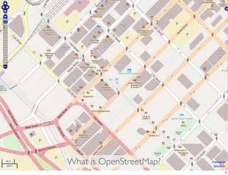
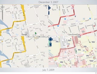
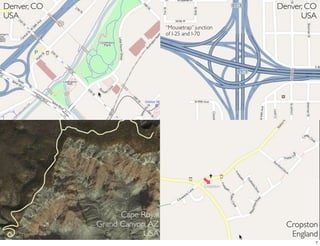
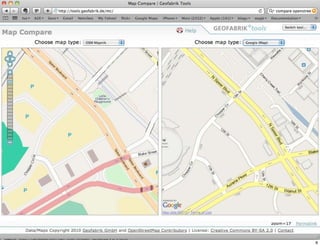
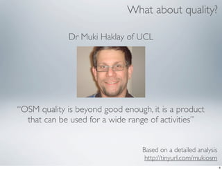
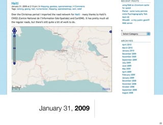
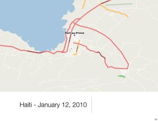
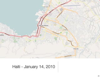
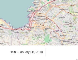
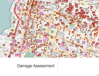
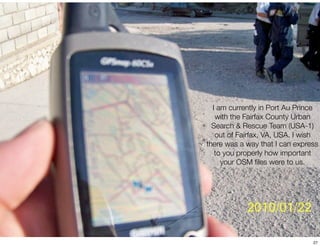
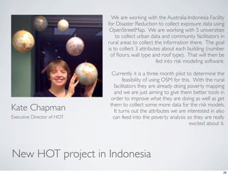
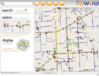
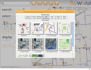
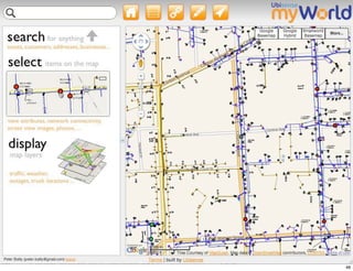
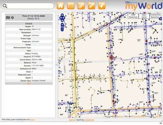
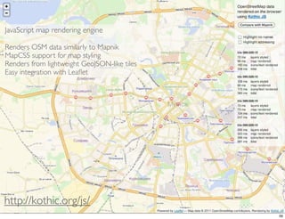
WHAT’S NEW IN
OPENSTREETMAP
     Peter Batty
      Ubisense


                   1
CONTRIBUTORS


  Mike Dolbow      Steve Chilton      Bernie Connors        Jens Winbladh
   St Paul, MN          UK         New Brunswick, Canada   Kolding, Denmark


                                                           Richard Fairhurst
                                                                  UK

                                                              Josh Doe

  Kate Chapman
aka @wonderchook
  Washington, DC


                                                                               2
INTRO TO OSM


               3
What is OpenStreetMap?
                         4
WHY BOTHER?
  As a mapper / user      As a developer
             It’s fun!!   It’s free!!
Map what you want         Access to vector data
          It’s useful     Download to mobile
 Faster corrections       devices


                                                  5
December 3, 2007


Google                      OpenStreetMap


            July 7, 2009
                                            6
Denver, CO                                             Denver, CO
USA                                                          USA
                                “Mousetrap” junction
                                of I-25 and I-70


                   Cape Royal
             Grand Canyon, AZ                            Cropston
                         USA                              England
                                                                7
8
What about quality?

              Dr Muki Haklay of UCL


“OSM quality is beyond good enough, it is a product
  that can be used for a wide range of activities”


                                  Based on a detailed analysis
                                   http://tinyurl.com/mukiosm
                                                                 9
Database
                                                                    2007 data
  69 countries
  11m miles (18m km) of roads
  18m points of interest              “Creating, maintaining and delivering a
People                            comprehensive, high quality map database is a
                                    multi-step, labor-intensive process. We
  Field force 700                  currently employ over 270 employees in our
                                    centralized production facility and a global
  Central production 270         workforce of over 700 geographic analysts in 32
                                                    countries”
  Technology 500
  Total 3349
Financial
  Revenue $853m (~€604m)
  Data creation & distribution costs       $396m           (~€280m)


                                                                                   10
Video at http://vimeo.com/2598878
                                    11
DATA CREATION


                12
Editing with
 Potlatch 2


               13
Straighten
     Circle
   Square
   Parallel


              14
15
16
http://frontdoor.cloudapp.net/
                                 17
Conflation tool for JOSM
       Josh Doe


                          18
19
ArcGIS Editor for OSM?


                         20
HUMANITARIAN OSM TEAM
        (HOT)


                        21
January 31, 2009

                   22
Haiti - January 12, 2010

                           23
Haiti - January 14, 2010

                           24
Haiti - January 26, 2010

                           25
Damage Assessment

                    26
I am currently in Port Au Prince
   with the Fairfax County Urban
  Search & Rescue Team (USA-1)
   out of Fairfax, VA, USA. I wish
there was a way that I can express
   to you properly how important
     your OSM files were to us.


                                27
We are working with the Australia-Indonesia Facility
                            for Disaster Reduction to collect exposure data using
                             OpenStreetMap.  We are working with 5 universities
                                to collect urban data and community facilitators in
                            rural areas to collect the information there.  The goal
                            is to collect 3 attributes about each building (number
                             of floors, wall type and roof type).  That will then be
                                                    fed into risk modeling software. 

                              Currently it is a three month pilot to determine the
                                    feasibility of using OSM for this.  With the rural
                               facilitators they are already doing poverty mapping
                               and we are just aiming to give them better tools in
                             order to improve what they are doing as well as get
                             them to collect some more data for the risk models. 
Kate Chapman                   It turns out the attributes we are interested in also
Executive Director of HOT     can feed into the poverty analysis so they are really
                                                                     excited about it.


New HOT project in Indonesia
                                                                                    28
Kampung Bali


               29
30
Correcting Information


                         31
32
33
34
35
36
ROUTING


          37
http://routingdemo.geofabrik.de/


                                   38
Danish Working Environment
   Authority (Arbejdstilsynet)

 Android application called VIVI shows
inspectors route between sites. Chose
  OSM because of licensing terms and
   availability of open source software.


              Runs on
             Galaxy Tab
                                           39
http://bit.ly/multimodaltripplanner


                                      40
http://opentripplanner.org/
                              41
“a good puzzle would
  be to cross Dublin
without passing a pub”

          James Joyce
              Ulysses


                         42
http://bit.ly/dublinpubs
                           43
APPLICATIONS


               44
45
46
47
48
49
50
51
52
53
54
DEVELOPMENT


              55
JavaScript map rendering engine

Renders OSM data similarly to Mapnik
MapCSS support for map styling
Renders from lightweight GeoJSON-like tiles
Easy integration with Leaflet


http://kothic.org/js/
                                              56
http://leaflet.cloudmade.com/


                               57

What's new with OpenStreetMap

  • 1.
    WHAT’S NEW IN OPENSTREETMAP Peter Batty Ubisense 1
  • 2.
    CONTRIBUTORS MikeDolbow Steve Chilton Bernie Connors Jens Winbladh St Paul, MN UK New Brunswick, Canada Kolding, Denmark Richard Fairhurst UK Josh Doe Kate Chapman aka @wonderchook Washington, DC 2
  • 3.
  • 4.
  • 5.
    WHY BOTHER? As a mapper / user As a developer It’s fun!! It’s free!! Map what you want Access to vector data It’s useful Download to mobile Faster corrections devices 5
  • 6.
    December 3, 2007 Google OpenStreetMap July 7, 2009 6
  • 7.
    Denver, CO Denver, CO USA USA “Mousetrap” junction of I-25 and I-70 Cape Royal Grand Canyon, AZ Cropston USA England 7
  • 8.
  • 9.
    What about quality? Dr Muki Haklay of UCL “OSM quality is beyond good enough, it is a product that can be used for a wide range of activities” Based on a detailed analysis http://tinyurl.com/mukiosm 9
  • 10.
    Database 2007 data 69 countries 11m miles (18m km) of roads 18m points of interest “Creating, maintaining and delivering a People comprehensive, high quality map database is a multi-step, labor-intensive process. We Field force 700 currently employ over 270 employees in our centralized production facility and a global Central production 270 workforce of over 700 geographic analysts in 32 countries” Technology 500 Total 3349 Financial Revenue $853m (~€604m) Data creation & distribution costs $396m (~€280m) 10
  • 11.
  • 12.
  • 13.
  • 14.
    Straighten Circle Square Parallel 14
  • 15.
  • 16.
  • 17.
  • 18.
    Conflation tool forJOSM Josh Doe 18
  • 19.
  • 20.
  • 21.
  • 22.
  • 23.
    Haiti - January12, 2010 23
  • 24.
    Haiti - January14, 2010 24
  • 25.
    Haiti - January26, 2010 25
  • 26.
  • 27.
    I am currentlyin Port Au Prince with the Fairfax County Urban Search & Rescue Team (USA-1) out of Fairfax, VA, USA. I wish there was a way that I can express to you properly how important your OSM files were to us. 27
  • 28.
    We are workingwith the Australia-Indonesia Facility for Disaster Reduction to collect exposure data using OpenStreetMap.  We are working with 5 universities to collect urban data and community facilitators in rural areas to collect the information there.  The goal is to collect 3 attributes about each building (number of floors, wall type and roof type).  That will then be fed into risk modeling software.  Currently it is a three month pilot to determine the feasibility of using OSM for this.  With the rural facilitators they are already doing poverty mapping and we are just aiming to give them better tools in order to improve what they are doing as well as get them to collect some more data for the risk models.  Kate Chapman It turns out the attributes we are interested in also Executive Director of HOT can feed into the poverty analysis so they are really excited about it. New HOT project in Indonesia 28
  • 29.
  • 30.
  • 31.
  • 32.
  • 33.
  • 34.
  • 35.
  • 36.
  • 37.
  • 38.
  • 39.
    Danish Working Environment Authority (Arbejdstilsynet) Android application called VIVI shows inspectors route between sites. Chose OSM because of licensing terms and availability of open source software. Runs on Galaxy Tab 39
  • 40.
  • 41.
  • 42.
    “a good puzzlewould be to cross Dublin without passing a pub” James Joyce Ulysses 42
  • 43.
  • 44.
  • 45.
  • 46.
  • 47.
  • 48.
  • 49.
  • 50.
  • 51.
  • 52.
  • 53.
  • 54.
  • 55.
  • 56.
    JavaScript map renderingengine Renders OSM data similarly to Mapnik MapCSS support for map styling Renders from lightweight GeoJSON-like tiles Easy integration with Leaflet http://kothic.org/js/ 56
  • 57.