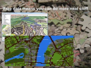
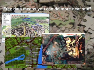
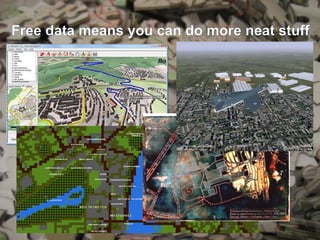
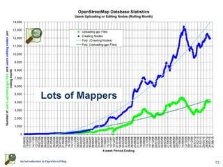
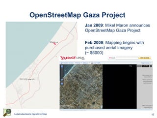
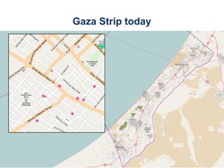
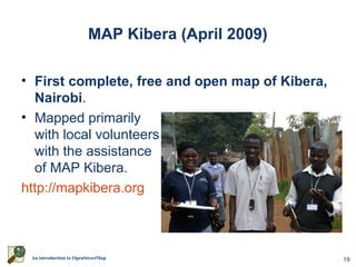
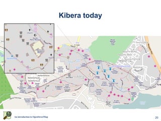
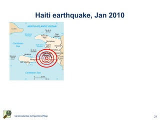
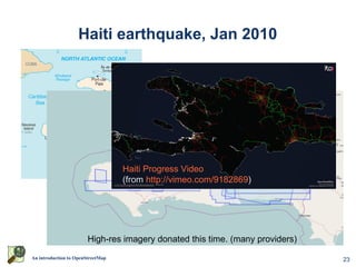
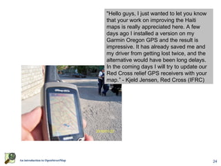
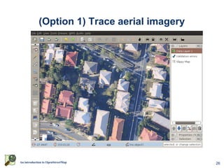
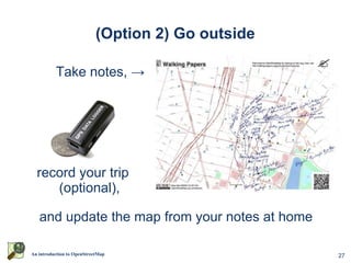
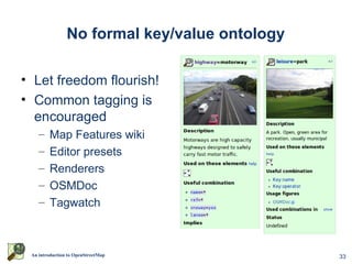
SlideShare a Scribd company logo
An introduction to OpenStreetMap

     presented by David Dean
                http://www.dbdean.com
   Slides will be available at http://www.slideshare.net/dbdean
What is OpenStreetMap?

• Geographic data
    – For driving, riding,
      walking, boating,
      skiing, hiking, anything
• Free
    – Currently CC-BY-SA,
      moving to ODBL
• Wiki-like editing
                                       http://www.osm.org


 An introduction to OpenStreetMap                           2
Why not just use Google Maps?


                      or WhereIs/Yahoo/Bing Maps?

               or whatever is on your GPS/Phone?


An introduction to OpenStreetMap                    3
Updated rapidly


                    Google                       OpenStreetMap


An introduction to OpenStreetMap                                 4
But, coverage can be poor


An introduction to OpenStreetMap                5
Not just for cars


An introduction to OpenStreetMap   6
Data freely available (and editable)


An introduction to OpenStreetMap              7
Raw traces are available too


An introduction to OpenStreetMap                8
Free data means you can do more neat stuff


  An introduction to OpenStreetMap           9
Free data means you can do more neat stuff


  An introduction to OpenStreetMap       10
Free data means you can do more neat stuff


  An introduction to OpenStreetMap       11
Free data means you can do more neat stuff


  An introduction to OpenStreetMap       12
Lots of Mappers


An introduction to OpenStreetMap   13
Worldwide activity


                                      OSM 2008: A Year of Edits
                                   (from http://vimeo.com/2598878)


An introduction to OpenStreetMap                                     14
Available on many devices
                                                          Garmin PNDs


 OffMaps on IPhone
                                                                                                     Garmin GPSs


                                                                        Gosmore on Windows Mobile


AndNav2 on Android
                                         GPSMid on J2ME                          MaemoMapper on Nokia Maemo


      An introduction to OpenStreetMap                                                                        15
Humanitarian OpenStreetMap Team


An introduction to OpenStreetMap      16
OpenStreetMap Gaza Project
                                   Jan 2009: Mikel Maron announces
                                   OpenStreetMap Gaza Project

                                   Feb 2009: Mapping begins with
                                   purchased aerial imagery
                                   (~ $6000)


An introduction to OpenStreetMap                                     17
Gaza Strip today


An introduction to OpenStreetMap                      18
MAP Kibera (April 2009)

• First complete, free and open map of Kibera,
  Nairobi.
• Mapped primarily
  with local volunteers
  with the assistance
  of MAP Kibera.
http://mapkibera.org


 An introduction to OpenStreetMap                  19
Kibera today


An introduction to OpenStreetMap                  20
Haiti earthquake, Jan 2010


An introduction to OpenStreetMap                 21
Haiti earthquake, Jan 2010


                        High-res imagery donated this time. (many providers)
An introduction to OpenStreetMap                                               22
Haiti earthquake, Jan 2010


                                   Haiti Progress Video
                                   (from http://vimeo.com/9182869)


                        High-res imagery donated this time. (many providers)
An introduction to OpenStreetMap                                               23
"Hello guys, I just wanted to let you know
                                         that your work on improving the Haiti
                                         maps is really appreciated here. A few
                                         days ago I installed a version on my
                                         Garmin Oregon GPS and the result is
                                         impressive. It has already saved me and
                                         my driver from getting lost twice, and the
                                         alternative would have been long delays.
                                         In the coming days I will try to update our
                                         Red Cross relief GPS receivers with your
                                         map.” - Kjeld Jensen, Red Cross (IFRC)


                    World Bank Situation Room


An introduction to OpenStreetMap                                                       24
So, how can you help map?


An introduction to OpenStreetMap             25
(Option 1) Trace aerial imagery


An introduction to OpenStreetMap              26
(Option 2) Go outside

          Take notes, →


  record your trip
     (optional),

   and update the map from your notes at home

An introduction to OpenStreetMap                    27
(Option 3) Tell someone about a problem


An introduction to OpenStreetMap          28
(Option 4) Be social

• Brisbane mapping events occur monthly
  – Alternate between mapping parties and meetups
• Next event: OSM Mapping Meetup
                       th
  – 7pm Monday 16 August at Grange Library
  – See http://bit.ly/bnemap for more details
• What is a mapping party?
  – A group of people get together to map a large area in a
    single day
  – Example: Macleay Island in November 2009
       (see http://youtu.be/oxV-nescElE)


  An introduction to OpenStreetMap                            29
MapMyTown @ Bell, Qld

• 30-31st October 2010
• SSSi Young Professionals
• http://bit.ly/mapmytown


 An introduction to OpenStreetMap               30
Questions?


Thanks for listening.


 An introduction to OpenStreetMap                31
Data representation

• Geographic information is
  represented as
   – Nodes
   – Ways
          • Ordered collections of nodes
          • Closed ways can be areas
   – Relations
          • Ordered collections of ways
            and nodes
• All can be tagged with
  any key/value pairs

 An introduction to OpenStreetMap                    32
No formal key/value ontology

• Let freedom flourish!
• Common tagging is
  encouraged
    –    Map Features wiki
    –    Editor presets
    –    Renderers
    –    OSMDoc
    –    Tagwatch


 An introduction to OpenStreetMap              33

More Related Content

What's hot

Open Cities Africa (Accra) - Stakeholders OpenStreetMap Introduction
Open Cities Africa (Accra) - Stakeholders OpenStreetMap IntroductionOpen Cities Africa (Accra) - Stakeholders OpenStreetMap Introduction
Open Cities Africa (Accra) - Stakeholders OpenStreetMap Introduction
Enock Seth Nyamador
 
OpenStreetMap Using, Tools, Services & Hows its changed Humanitarian Response
OpenStreetMap Using, Tools, Services & Hows its changed Humanitarian ResponseOpenStreetMap Using, Tools, Services & Hows its changed Humanitarian Response
OpenStreetMap Using, Tools, Services & Hows its changed Humanitarian Response
chippy
 
Osm Presentation
Osm PresentationOsm Presentation
Osm Presentation
jhgreenblatt
 
JRC OpenStreetMap, editing and tasking mechanisms, 20130326
JRC OpenStreetMap, editing and tasking mechanisms, 20130326JRC OpenStreetMap, editing and tasking mechanisms, 20130326
JRC OpenStreetMap, editing and tasking mechanisms, 20130326
Severin Menard
 
Introduction to OpenStreetMap and Humanitarian OSM Team for Plan Internationa...
Introduction to OpenStreetMap and Humanitarian OSM Team for Plan Internationa...Introduction to OpenStreetMap and Humanitarian OSM Team for Plan Internationa...
Introduction to OpenStreetMap and Humanitarian OSM Team for Plan Internationa...
chippy
 
Leeds Data Thing OpenStreetMap and Other Geo Visualization Stuff
Leeds Data Thing OpenStreetMap and Other Geo Visualization StuffLeeds Data Thing OpenStreetMap and Other Geo Visualization Stuff
Leeds Data Thing OpenStreetMap and Other Geo Visualization Stuff
chippy
 
Haiti Qake2010 Bar Camp Canberra2010
Haiti Qake2010 Bar Camp Canberra2010Haiti Qake2010 Bar Camp Canberra2010
Haiti Qake2010 Bar Camp Canberra2010
Shoaib Burq
 
HOT OSM Community mapping in Lower Shire, Malawi
HOT OSM Community mapping in Lower Shire, MalawiHOT OSM Community mapping in Lower Shire, Malawi
HOT OSM Community mapping in Lower Shire, Malawi
Severin Menard
 
Ieee 2014 tech_training_open_streetmap_20121011
Ieee 2014 tech_training_open_streetmap_20121011Ieee 2014 tech_training_open_streetmap_20121011
Ieee 2014 tech_training_open_streetmap_20121011
ALCE Samuel Paul
 
Presenting OpenStreetMap in Ghana during Project Flood Risk Accra Workshop
Presenting OpenStreetMap in Ghana during Project Flood Risk Accra WorkshopPresenting OpenStreetMap in Ghana during Project Flood Risk Accra Workshop
Presenting OpenStreetMap in Ghana during Project Flood Risk Accra Workshop
Enock Seth Nyamador
 
Open streetmap response-to-ebola-crisis-geong-2014-09-23
Open streetmap response-to-ebola-crisis-geong-2014-09-23Open streetmap response-to-ebola-crisis-geong-2014-09-23
Open streetmap response-to-ebola-crisis-geong-2014-09-23
Pierre Béland
 
Open street map final ppt
Open street map final pptOpen street map final ppt
Open street map final ppt
Prashant Menon
 
Openstreetmap presentation of Mapping Party at FSMK camp
Openstreetmap presentation of Mapping Party at FSMK campOpenstreetmap presentation of Mapping Party at FSMK camp
Openstreetmap presentation of Mapping Party at FSMK camp
Yogesh Ks
 
DSD-INT 2016 A crowd-sourced spatial database can change the way we work - Va...
DSD-INT 2016 A crowd-sourced spatial database can change the way we work - Va...DSD-INT 2016 A crowd-sourced spatial database can change the way we work - Va...
DSD-INT 2016 A crowd-sourced spatial database can change the way we work - Va...
Deltares
 
Open streetmap
Open streetmapOpen streetmap
Open streetmap
BGTT_SYD
 
OpenStreetMap - HOT - DokuTech
OpenStreetMap - HOT - DokuTechOpenStreetMap - HOT - DokuTech
OpenStreetMap - HOT - DokuTech
Besfort Guri
 
How Crowdsourcing Changed Disaster Relief Forever (Web 2.0 Summit Ignite vers...
How Crowdsourcing Changed Disaster Relief Forever (Web 2.0 Summit Ignite vers...How Crowdsourcing Changed Disaster Relief Forever (Web 2.0 Summit Ignite vers...
How Crowdsourcing Changed Disaster Relief Forever (Web 2.0 Summit Ignite vers...
Schuyler Erle
 
Openstreetmap and its value during emergencies
Openstreetmap and its value during emergenciesOpenstreetmap and its value during emergencies
Openstreetmap and its value during emergencies
Ervin Malicdem
 
OpenStreetMap-Introduction
OpenStreetMap-IntroductionOpenStreetMap-Introduction
OpenStreetMap-Introduction
Philippe Rieffel
 
Introduction to OpenStreetMap, its extracts, and relation to Project NOAH
Introduction to OpenStreetMap, its extracts, and relation to Project NOAHIntroduction to OpenStreetMap, its extracts, and relation to Project NOAH
Introduction to OpenStreetMap, its extracts, and relation to Project NOAH
Ervin Malicdem
 

What's hot (20)

Open Cities Africa (Accra) - Stakeholders OpenStreetMap Introduction
Open Cities Africa (Accra) - Stakeholders OpenStreetMap IntroductionOpen Cities Africa (Accra) - Stakeholders OpenStreetMap Introduction
Open Cities Africa (Accra) - Stakeholders OpenStreetMap Introduction
 
OpenStreetMap Using, Tools, Services & Hows its changed Humanitarian Response
OpenStreetMap Using, Tools, Services & Hows its changed Humanitarian ResponseOpenStreetMap Using, Tools, Services & Hows its changed Humanitarian Response
OpenStreetMap Using, Tools, Services & Hows its changed Humanitarian Response
 
Osm Presentation
Osm PresentationOsm Presentation
Osm Presentation
 
JRC OpenStreetMap, editing and tasking mechanisms, 20130326
JRC OpenStreetMap, editing and tasking mechanisms, 20130326JRC OpenStreetMap, editing and tasking mechanisms, 20130326
JRC OpenStreetMap, editing and tasking mechanisms, 20130326
 
Introduction to OpenStreetMap and Humanitarian OSM Team for Plan Internationa...
Introduction to OpenStreetMap and Humanitarian OSM Team for Plan Internationa...Introduction to OpenStreetMap and Humanitarian OSM Team for Plan Internationa...
Introduction to OpenStreetMap and Humanitarian OSM Team for Plan Internationa...
 
Leeds Data Thing OpenStreetMap and Other Geo Visualization Stuff
Leeds Data Thing OpenStreetMap and Other Geo Visualization StuffLeeds Data Thing OpenStreetMap and Other Geo Visualization Stuff
Leeds Data Thing OpenStreetMap and Other Geo Visualization Stuff
 
Haiti Qake2010 Bar Camp Canberra2010
Haiti Qake2010 Bar Camp Canberra2010Haiti Qake2010 Bar Camp Canberra2010
Haiti Qake2010 Bar Camp Canberra2010
 
HOT OSM Community mapping in Lower Shire, Malawi
HOT OSM Community mapping in Lower Shire, MalawiHOT OSM Community mapping in Lower Shire, Malawi
HOT OSM Community mapping in Lower Shire, Malawi
 
Ieee 2014 tech_training_open_streetmap_20121011
Ieee 2014 tech_training_open_streetmap_20121011Ieee 2014 tech_training_open_streetmap_20121011
Ieee 2014 tech_training_open_streetmap_20121011
 
Presenting OpenStreetMap in Ghana during Project Flood Risk Accra Workshop
Presenting OpenStreetMap in Ghana during Project Flood Risk Accra WorkshopPresenting OpenStreetMap in Ghana during Project Flood Risk Accra Workshop
Presenting OpenStreetMap in Ghana during Project Flood Risk Accra Workshop
 
Open streetmap response-to-ebola-crisis-geong-2014-09-23
Open streetmap response-to-ebola-crisis-geong-2014-09-23Open streetmap response-to-ebola-crisis-geong-2014-09-23
Open streetmap response-to-ebola-crisis-geong-2014-09-23
 
Open street map final ppt
Open street map final pptOpen street map final ppt
Open street map final ppt
 
Openstreetmap presentation of Mapping Party at FSMK camp
Openstreetmap presentation of Mapping Party at FSMK campOpenstreetmap presentation of Mapping Party at FSMK camp
Openstreetmap presentation of Mapping Party at FSMK camp
 
DSD-INT 2016 A crowd-sourced spatial database can change the way we work - Va...
DSD-INT 2016 A crowd-sourced spatial database can change the way we work - Va...DSD-INT 2016 A crowd-sourced spatial database can change the way we work - Va...
DSD-INT 2016 A crowd-sourced spatial database can change the way we work - Va...
 
Open streetmap
Open streetmapOpen streetmap
Open streetmap
 
OpenStreetMap - HOT - DokuTech
OpenStreetMap - HOT - DokuTechOpenStreetMap - HOT - DokuTech
OpenStreetMap - HOT - DokuTech
 
How Crowdsourcing Changed Disaster Relief Forever (Web 2.0 Summit Ignite vers...
How Crowdsourcing Changed Disaster Relief Forever (Web 2.0 Summit Ignite vers...How Crowdsourcing Changed Disaster Relief Forever (Web 2.0 Summit Ignite vers...
How Crowdsourcing Changed Disaster Relief Forever (Web 2.0 Summit Ignite vers...
 
Openstreetmap and its value during emergencies
Openstreetmap and its value during emergenciesOpenstreetmap and its value during emergencies
Openstreetmap and its value during emergencies
 
OpenStreetMap-Introduction
OpenStreetMap-IntroductionOpenStreetMap-Introduction
OpenStreetMap-Introduction
 
Introduction to OpenStreetMap, its extracts, and relation to Project NOAH
Introduction to OpenStreetMap, its extracts, and relation to Project NOAHIntroduction to OpenStreetMap, its extracts, and relation to Project NOAH
Introduction to OpenStreetMap, its extracts, and relation to Project NOAH
 

Similar to An Introduction to OpenStreetMap (UQ GIS Students)

Stanford Presentation to GISSIG
Stanford Presentation to GISSIGStanford Presentation to GISSIG
Stanford Presentation to GISSIG
Sarah_Manley
 
Intro to OpenStreetMap- UC Merced 4.22.09
Intro to OpenStreetMap- UC Merced 4.22.09Intro to OpenStreetMap- UC Merced 4.22.09
Intro to OpenStreetMap- UC Merced 4.22.09
Sarah_Manley
 
Open Geo Data in Italy and the OpenStreetMap case
Open Geo Data in Italy and the OpenStreetMap caseOpen Geo Data in Italy and the OpenStreetMap case
Open Geo Data in Italy and the OpenStreetMap case
Maurizio Napolitano
 
Crowdsource the Map! And Intro to OpenStreetMap - Sargent McDonald
Crowdsource the Map! And Intro to OpenStreetMap - Sargent McDonaldCrowdsource the Map! And Intro to OpenStreetMap - Sargent McDonald
Crowdsource the Map! And Intro to OpenStreetMap - Sargent McDonald
Open Colorado - Colorado Smart Communities
 
[Day 3] Agcommons Quickwin: gRoads
[Day 3] Agcommons Quickwin: gRoads[Day 3] Agcommons Quickwin: gRoads
[Day 3] Agcommons Quickwin: gRoads
csi2009
 
OpenStreetMap
OpenStreetMapOpenStreetMap
OpenStreetMap
Martijn van Exel
 
Talk: "Using Open Data and Crowdsourcing to develop CycleStreets"
Talk: "Using Open Data and Crowdsourcing to develop CycleStreets"Talk: "Using Open Data and Crowdsourcing to develop CycleStreets"
Talk: "Using Open Data and Crowdsourcing to develop CycleStreets"
CycleStreets
 
From a niche to a global user community: Open Source GIS and OSGeo
From a niche to a global user community: Open Source GIS and OSGeoFrom a niche to a global user community: Open Source GIS and OSGeo
From a niche to a global user community: Open Source GIS and OSGeo
Markus Neteler
 
Answer togoogleearthuniverseandevrythingelse abbreviated
Answer togoogleearthuniverseandevrythingelse abbreviatedAnswer togoogleearthuniverseandevrythingelse abbreviated
Answer togoogleearthuniverseandevrythingelse abbreviated
Shashank Singh
 
Web Mapping with Drupal
Web Mapping with DrupalWeb Mapping with Drupal
Web Mapping with Drupal
Ranel Padon
 
Open streetmapによる鳥取ガイドの試み3
Open streetmapによる鳥取ガイドの試み3Open streetmapによる鳥取ガイドの試み3
Open streetmapによる鳥取ガイドの試み3
Hiroyuki Nakaji
 
OpenMappingAfrica
OpenMappingAfricaOpenMappingAfrica
OpenMappingAfrica
mikel_maron
 
OpenStreetMap and CycleStreets: collaborative map-making and cartography in t...
OpenStreetMap and CycleStreets: collaborative map-making and cartography in t...OpenStreetMap and CycleStreets: collaborative map-making and cartography in t...
OpenStreetMap and CycleStreets: collaborative map-making and cartography in t...
CycleStreets
 
What's new with OpenStreetMap
What's new with OpenStreetMapWhat's new with OpenStreetMap
What's new with OpenStreetMap
Peter Batty
 
OSGeo Live - DokuTech
OSGeo Live - DokuTechOSGeo Live - DokuTech
OSGeo Live - DokuTech
Besfort Guri
 
OpenStreetMap integration into Wikimedia projects
OpenStreetMap integration into Wikimedia projectsOpenStreetMap integration into Wikimedia projects
OpenStreetMap integration into Wikimedia projects
avarab
 
Sharing the Openness of the Maps via FOSS4G and the Web
Sharing the Openness of the Maps via FOSS4G and the WebSharing the Openness of the Maps via FOSS4G and the Web
Sharing the Openness of the Maps via FOSS4G and the Web
Hidenori Fujimura
 
OSM HOT SBTF 2013_03_16
OSM HOT SBTF 2013_03_16OSM HOT SBTF 2013_03_16
OSM HOT SBTF 2013_03_16
Frédéric Bonifas
 
OpenStreetMap Response to Haiti earthquake
OpenStreetMap Response to Haiti earthquake OpenStreetMap Response to Haiti earthquake
OpenStreetMap Response to Haiti earthquake
Shoaib Burq
 
OpenStreetMap Sri Lanka
OpenStreetMap Sri LankaOpenStreetMap Sri Lanka
OpenStreetMap Sri Lanka
Jeff Haack
 

Similar to An Introduction to OpenStreetMap (UQ GIS Students) (20)

Stanford Presentation to GISSIG
Stanford Presentation to GISSIGStanford Presentation to GISSIG
Stanford Presentation to GISSIG
 
Intro to OpenStreetMap- UC Merced 4.22.09
Intro to OpenStreetMap- UC Merced 4.22.09Intro to OpenStreetMap- UC Merced 4.22.09
Intro to OpenStreetMap- UC Merced 4.22.09
 
Open Geo Data in Italy and the OpenStreetMap case
Open Geo Data in Italy and the OpenStreetMap caseOpen Geo Data in Italy and the OpenStreetMap case
Open Geo Data in Italy and the OpenStreetMap case
 
Crowdsource the Map! And Intro to OpenStreetMap - Sargent McDonald
Crowdsource the Map! And Intro to OpenStreetMap - Sargent McDonaldCrowdsource the Map! And Intro to OpenStreetMap - Sargent McDonald
Crowdsource the Map! And Intro to OpenStreetMap - Sargent McDonald
 
[Day 3] Agcommons Quickwin: gRoads
[Day 3] Agcommons Quickwin: gRoads[Day 3] Agcommons Quickwin: gRoads
[Day 3] Agcommons Quickwin: gRoads
 
OpenStreetMap
OpenStreetMapOpenStreetMap
OpenStreetMap
 
Talk: "Using Open Data and Crowdsourcing to develop CycleStreets"
Talk: "Using Open Data and Crowdsourcing to develop CycleStreets"Talk: "Using Open Data and Crowdsourcing to develop CycleStreets"
Talk: "Using Open Data and Crowdsourcing to develop CycleStreets"
 
From a niche to a global user community: Open Source GIS and OSGeo
From a niche to a global user community: Open Source GIS and OSGeoFrom a niche to a global user community: Open Source GIS and OSGeo
From a niche to a global user community: Open Source GIS and OSGeo
 
Answer togoogleearthuniverseandevrythingelse abbreviated
Answer togoogleearthuniverseandevrythingelse abbreviatedAnswer togoogleearthuniverseandevrythingelse abbreviated
Answer togoogleearthuniverseandevrythingelse abbreviated
 
Web Mapping with Drupal
Web Mapping with DrupalWeb Mapping with Drupal
Web Mapping with Drupal
 
Open streetmapによる鳥取ガイドの試み3
Open streetmapによる鳥取ガイドの試み3Open streetmapによる鳥取ガイドの試み3
Open streetmapによる鳥取ガイドの試み3
 
OpenMappingAfrica
OpenMappingAfricaOpenMappingAfrica
OpenMappingAfrica
 
OpenStreetMap and CycleStreets: collaborative map-making and cartography in t...
OpenStreetMap and CycleStreets: collaborative map-making and cartography in t...OpenStreetMap and CycleStreets: collaborative map-making and cartography in t...
OpenStreetMap and CycleStreets: collaborative map-making and cartography in t...
 
What's new with OpenStreetMap
What's new with OpenStreetMapWhat's new with OpenStreetMap
What's new with OpenStreetMap
 
OSGeo Live - DokuTech
OSGeo Live - DokuTechOSGeo Live - DokuTech
OSGeo Live - DokuTech
 
OpenStreetMap integration into Wikimedia projects
OpenStreetMap integration into Wikimedia projectsOpenStreetMap integration into Wikimedia projects
OpenStreetMap integration into Wikimedia projects
 
Sharing the Openness of the Maps via FOSS4G and the Web
Sharing the Openness of the Maps via FOSS4G and the WebSharing the Openness of the Maps via FOSS4G and the Web
Sharing the Openness of the Maps via FOSS4G and the Web
 
OSM HOT SBTF 2013_03_16
OSM HOT SBTF 2013_03_16OSM HOT SBTF 2013_03_16
OSM HOT SBTF 2013_03_16
 
OpenStreetMap Response to Haiti earthquake
OpenStreetMap Response to Haiti earthquake OpenStreetMap Response to Haiti earthquake
OpenStreetMap Response to Haiti earthquake
 
OpenStreetMap Sri Lanka
OpenStreetMap Sri LankaOpenStreetMap Sri Lanka
OpenStreetMap Sri Lanka
 

Recently uploaded

Securing your Kubernetes cluster_ a step-by-step guide to success !
Securing your Kubernetes cluster_ a step-by-step guide to success !Securing your Kubernetes cluster_ a step-by-step guide to success !
Securing your Kubernetes cluster_ a step-by-step guide to success !
KatiaHIMEUR1
 
Enchancing adoption of Open Source Libraries. A case study on Albumentations.AI
Enchancing adoption of Open Source Libraries. A case study on Albumentations.AIEnchancing adoption of Open Source Libraries. A case study on Albumentations.AI
Enchancing adoption of Open Source Libraries. A case study on Albumentations.AI
Vladimir Iglovikov, Ph.D.
 
20240607 QFM018 Elixir Reading List May 2024
20240607 QFM018 Elixir Reading List May 202420240607 QFM018 Elixir Reading List May 2024
20240607 QFM018 Elixir Reading List May 2024
Matthew Sinclair
 
Climate Impact of Software Testing at Nordic Testing Days
Climate Impact of Software Testing at Nordic Testing DaysClimate Impact of Software Testing at Nordic Testing Days
Climate Impact of Software Testing at Nordic Testing Days
Kari Kakkonen
 
Removing Uninteresting Bytes in Software Fuzzing
Removing Uninteresting Bytes in Software FuzzingRemoving Uninteresting Bytes in Software Fuzzing
Removing Uninteresting Bytes in Software Fuzzing
Aftab Hussain
 
GraphSummit Singapore | Enhancing Changi Airport Group's Passenger Experience...
GraphSummit Singapore | Enhancing Changi Airport Group's Passenger Experience...GraphSummit Singapore | Enhancing Changi Airport Group's Passenger Experience...
GraphSummit Singapore | Enhancing Changi Airport Group's Passenger Experience...
Neo4j
 
How to use Firebase Data Connect For Flutter
How to use Firebase Data Connect For FlutterHow to use Firebase Data Connect For Flutter
How to use Firebase Data Connect For Flutter
Daiki Mogmet Ito
 
Data structures and Algorithms in Python.pdf
Data structures and Algorithms in Python.pdfData structures and Algorithms in Python.pdf
Data structures and Algorithms in Python.pdf
TIPNGVN2
 
Mind map of terminologies used in context of Generative AI
Mind map of terminologies used in context of Generative AIMind map of terminologies used in context of Generative AI
Mind map of terminologies used in context of Generative AI
Kumud Singh
 
UiPath Test Automation using UiPath Test Suite series, part 5
UiPath Test Automation using UiPath Test Suite series, part 5UiPath Test Automation using UiPath Test Suite series, part 5
UiPath Test Automation using UiPath Test Suite series, part 5
DianaGray10
 
Generative AI Deep Dive: Advancing from Proof of Concept to Production
Generative AI Deep Dive: Advancing from Proof of Concept to ProductionGenerative AI Deep Dive: Advancing from Proof of Concept to Production
Generative AI Deep Dive: Advancing from Proof of Concept to Production
Aggregage
 
RESUME BUILDER APPLICATION Project for students
RESUME BUILDER APPLICATION Project for studentsRESUME BUILDER APPLICATION Project for students
RESUME BUILDER APPLICATION Project for students
KAMESHS29
 
Large Language Model (LLM) and it’s Geospatial Applications
Large Language Model (LLM) and it’s Geospatial ApplicationsLarge Language Model (LLM) and it’s Geospatial Applications
Large Language Model (LLM) and it’s Geospatial Applications
Rohit Gautam
 
Pushing the limits of ePRTC: 100ns holdover for 100 days
Pushing the limits of ePRTC: 100ns holdover for 100 daysPushing the limits of ePRTC: 100ns holdover for 100 days
Pushing the limits of ePRTC: 100ns holdover for 100 days
Adtran
 
Building RAG with self-deployed Milvus vector database and Snowpark Container...
Building RAG with self-deployed Milvus vector database and Snowpark Container...Building RAG with self-deployed Milvus vector database and Snowpark Container...
Building RAG with self-deployed Milvus vector database and Snowpark Container...
Zilliz
 
Presentation of the OECD Artificial Intelligence Review of Germany
Presentation of the OECD Artificial Intelligence Review of GermanyPresentation of the OECD Artificial Intelligence Review of Germany
Presentation of the OECD Artificial Intelligence Review of Germany
innovationoecd
 
Unlock the Future of Search with MongoDB Atlas_ Vector Search Unleashed.pdf
Unlock the Future of Search with MongoDB Atlas_ Vector Search Unleashed.pdfUnlock the Future of Search with MongoDB Atlas_ Vector Search Unleashed.pdf
Unlock the Future of Search with MongoDB Atlas_ Vector Search Unleashed.pdf
Malak Abu Hammad
 
PCI PIN Basics Webinar from the Controlcase Team
PCI PIN Basics Webinar from the Controlcase TeamPCI PIN Basics Webinar from the Controlcase Team
PCI PIN Basics Webinar from the Controlcase Team
ControlCase
 
National Security Agency - NSA mobile device best practices
National Security Agency - NSA mobile device best practicesNational Security Agency - NSA mobile device best practices
National Security Agency - NSA mobile device best practices
Quotidiano Piemontese
 
UiPath Test Automation using UiPath Test Suite series, part 6
UiPath Test Automation using UiPath Test Suite series, part 6UiPath Test Automation using UiPath Test Suite series, part 6
UiPath Test Automation using UiPath Test Suite series, part 6
DianaGray10
 

Recently uploaded (20)

Securing your Kubernetes cluster_ a step-by-step guide to success !
Securing your Kubernetes cluster_ a step-by-step guide to success !Securing your Kubernetes cluster_ a step-by-step guide to success !
Securing your Kubernetes cluster_ a step-by-step guide to success !
 
Enchancing adoption of Open Source Libraries. A case study on Albumentations.AI
Enchancing adoption of Open Source Libraries. A case study on Albumentations.AIEnchancing adoption of Open Source Libraries. A case study on Albumentations.AI
Enchancing adoption of Open Source Libraries. A case study on Albumentations.AI
 
20240607 QFM018 Elixir Reading List May 2024
20240607 QFM018 Elixir Reading List May 202420240607 QFM018 Elixir Reading List May 2024
20240607 QFM018 Elixir Reading List May 2024
 
Climate Impact of Software Testing at Nordic Testing Days
Climate Impact of Software Testing at Nordic Testing DaysClimate Impact of Software Testing at Nordic Testing Days
Climate Impact of Software Testing at Nordic Testing Days
 
Removing Uninteresting Bytes in Software Fuzzing
Removing Uninteresting Bytes in Software FuzzingRemoving Uninteresting Bytes in Software Fuzzing
Removing Uninteresting Bytes in Software Fuzzing
 
GraphSummit Singapore | Enhancing Changi Airport Group's Passenger Experience...
GraphSummit Singapore | Enhancing Changi Airport Group's Passenger Experience...GraphSummit Singapore | Enhancing Changi Airport Group's Passenger Experience...
GraphSummit Singapore | Enhancing Changi Airport Group's Passenger Experience...
 
How to use Firebase Data Connect For Flutter
How to use Firebase Data Connect For FlutterHow to use Firebase Data Connect For Flutter
How to use Firebase Data Connect For Flutter
 
Data structures and Algorithms in Python.pdf
Data structures and Algorithms in Python.pdfData structures and Algorithms in Python.pdf
Data structures and Algorithms in Python.pdf
 
Mind map of terminologies used in context of Generative AI
Mind map of terminologies used in context of Generative AIMind map of terminologies used in context of Generative AI
Mind map of terminologies used in context of Generative AI
 
UiPath Test Automation using UiPath Test Suite series, part 5
UiPath Test Automation using UiPath Test Suite series, part 5UiPath Test Automation using UiPath Test Suite series, part 5
UiPath Test Automation using UiPath Test Suite series, part 5
 
Generative AI Deep Dive: Advancing from Proof of Concept to Production
Generative AI Deep Dive: Advancing from Proof of Concept to ProductionGenerative AI Deep Dive: Advancing from Proof of Concept to Production
Generative AI Deep Dive: Advancing from Proof of Concept to Production
 
RESUME BUILDER APPLICATION Project for students
RESUME BUILDER APPLICATION Project for studentsRESUME BUILDER APPLICATION Project for students
RESUME BUILDER APPLICATION Project for students
 
Large Language Model (LLM) and it’s Geospatial Applications
Large Language Model (LLM) and it’s Geospatial ApplicationsLarge Language Model (LLM) and it’s Geospatial Applications
Large Language Model (LLM) and it’s Geospatial Applications
 
Pushing the limits of ePRTC: 100ns holdover for 100 days
Pushing the limits of ePRTC: 100ns holdover for 100 daysPushing the limits of ePRTC: 100ns holdover for 100 days
Pushing the limits of ePRTC: 100ns holdover for 100 days
 
Building RAG with self-deployed Milvus vector database and Snowpark Container...
Building RAG with self-deployed Milvus vector database and Snowpark Container...Building RAG with self-deployed Milvus vector database and Snowpark Container...
Building RAG with self-deployed Milvus vector database and Snowpark Container...
 
Presentation of the OECD Artificial Intelligence Review of Germany
Presentation of the OECD Artificial Intelligence Review of GermanyPresentation of the OECD Artificial Intelligence Review of Germany
Presentation of the OECD Artificial Intelligence Review of Germany
 
Unlock the Future of Search with MongoDB Atlas_ Vector Search Unleashed.pdf
Unlock the Future of Search with MongoDB Atlas_ Vector Search Unleashed.pdfUnlock the Future of Search with MongoDB Atlas_ Vector Search Unleashed.pdf
Unlock the Future of Search with MongoDB Atlas_ Vector Search Unleashed.pdf
 
PCI PIN Basics Webinar from the Controlcase Team
PCI PIN Basics Webinar from the Controlcase TeamPCI PIN Basics Webinar from the Controlcase Team
PCI PIN Basics Webinar from the Controlcase Team
 
National Security Agency - NSA mobile device best practices
National Security Agency - NSA mobile device best practicesNational Security Agency - NSA mobile device best practices
National Security Agency - NSA mobile device best practices
 
UiPath Test Automation using UiPath Test Suite series, part 6
UiPath Test Automation using UiPath Test Suite series, part 6UiPath Test Automation using UiPath Test Suite series, part 6
UiPath Test Automation using UiPath Test Suite series, part 6
 

An Introduction to OpenStreetMap (UQ GIS Students)

  • 1. An introduction to OpenStreetMap presented by David Dean http://www.dbdean.com Slides will be available at http://www.slideshare.net/dbdean
  • 2. What is OpenStreetMap? • Geographic data – For driving, riding, walking, boating, skiing, hiking, anything • Free – Currently CC-BY-SA, moving to ODBL • Wiki-like editing http://www.osm.org An introduction to OpenStreetMap 2
  • 3. Why not just use Google Maps? or WhereIs/Yahoo/Bing Maps? or whatever is on your GPS/Phone? An introduction to OpenStreetMap 3
  • 4. Updated rapidly Google OpenStreetMap An introduction to OpenStreetMap 4
  • 5. But, coverage can be poor An introduction to OpenStreetMap 5
  • 6. Not just for cars An introduction to OpenStreetMap 6
  • 7. Data freely available (and editable) An introduction to OpenStreetMap 7
  • 8. Raw traces are available too An introduction to OpenStreetMap 8
  • 9. Free data means you can do more neat stuff An introduction to OpenStreetMap 9
  • 10. Free data means you can do more neat stuff An introduction to OpenStreetMap 10
  • 11. Free data means you can do more neat stuff An introduction to OpenStreetMap 11
  • 12. Free data means you can do more neat stuff An introduction to OpenStreetMap 12
  • 13. Lots of Mappers An introduction to OpenStreetMap 13
  • 14. Worldwide activity OSM 2008: A Year of Edits (from http://vimeo.com/2598878) An introduction to OpenStreetMap 14
  • 15. Available on many devices Garmin PNDs OffMaps on IPhone Garmin GPSs Gosmore on Windows Mobile AndNav2 on Android GPSMid on J2ME MaemoMapper on Nokia Maemo An introduction to OpenStreetMap 15
  • 16. Humanitarian OpenStreetMap Team An introduction to OpenStreetMap 16
  • 17. OpenStreetMap Gaza Project Jan 2009: Mikel Maron announces OpenStreetMap Gaza Project Feb 2009: Mapping begins with purchased aerial imagery (~ $6000) An introduction to OpenStreetMap 17
  • 18. Gaza Strip today An introduction to OpenStreetMap 18
  • 19. MAP Kibera (April 2009) • First complete, free and open map of Kibera, Nairobi. • Mapped primarily with local volunteers with the assistance of MAP Kibera. http://mapkibera.org An introduction to OpenStreetMap 19
  • 20. Kibera today An introduction to OpenStreetMap 20
  • 21. Haiti earthquake, Jan 2010 An introduction to OpenStreetMap 21
  • 22. Haiti earthquake, Jan 2010 High-res imagery donated this time. (many providers) An introduction to OpenStreetMap 22
  • 23. Haiti earthquake, Jan 2010 Haiti Progress Video (from http://vimeo.com/9182869) High-res imagery donated this time. (many providers) An introduction to OpenStreetMap 23
  • 24. "Hello guys, I just wanted to let you know that your work on improving the Haiti maps is really appreciated here. A few days ago I installed a version on my Garmin Oregon GPS and the result is impressive. It has already saved me and my driver from getting lost twice, and the alternative would have been long delays. In the coming days I will try to update our Red Cross relief GPS receivers with your map.” - Kjeld Jensen, Red Cross (IFRC) World Bank Situation Room An introduction to OpenStreetMap 24
  • 25. So, how can you help map? An introduction to OpenStreetMap 25
  • 26. (Option 1) Trace aerial imagery An introduction to OpenStreetMap 26
  • 27. (Option 2) Go outside Take notes, → record your trip (optional), and update the map from your notes at home An introduction to OpenStreetMap 27
  • 28. (Option 3) Tell someone about a problem An introduction to OpenStreetMap 28
  • 29. (Option 4) Be social • Brisbane mapping events occur monthly – Alternate between mapping parties and meetups • Next event: OSM Mapping Meetup th – 7pm Monday 16 August at Grange Library – See http://bit.ly/bnemap for more details • What is a mapping party? – A group of people get together to map a large area in a single day – Example: Macleay Island in November 2009 (see http://youtu.be/oxV-nescElE) An introduction to OpenStreetMap 29
  • 30. MapMyTown @ Bell, Qld • 30-31st October 2010 • SSSi Young Professionals • http://bit.ly/mapmytown An introduction to OpenStreetMap 30
  • 31. Questions? Thanks for listening. An introduction to OpenStreetMap 31
  • 32. Data representation • Geographic information is represented as – Nodes – Ways • Ordered collections of nodes • Closed ways can be areas – Relations • Ordered collections of ways and nodes • All can be tagged with any key/value pairs An introduction to OpenStreetMap 32
  • 33. No formal key/value ontology • Let freedom flourish! • Common tagging is encouraged – Map Features wiki – Editor presets – Renderers – OSMDoc – Tagwatch An introduction to OpenStreetMap 33