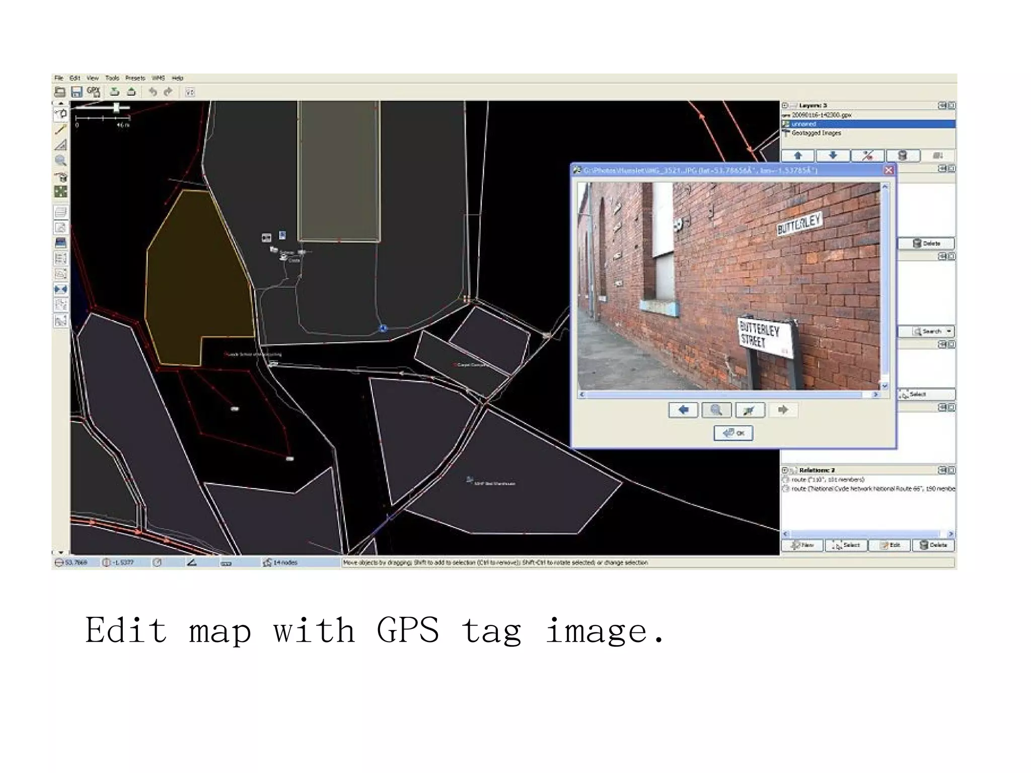
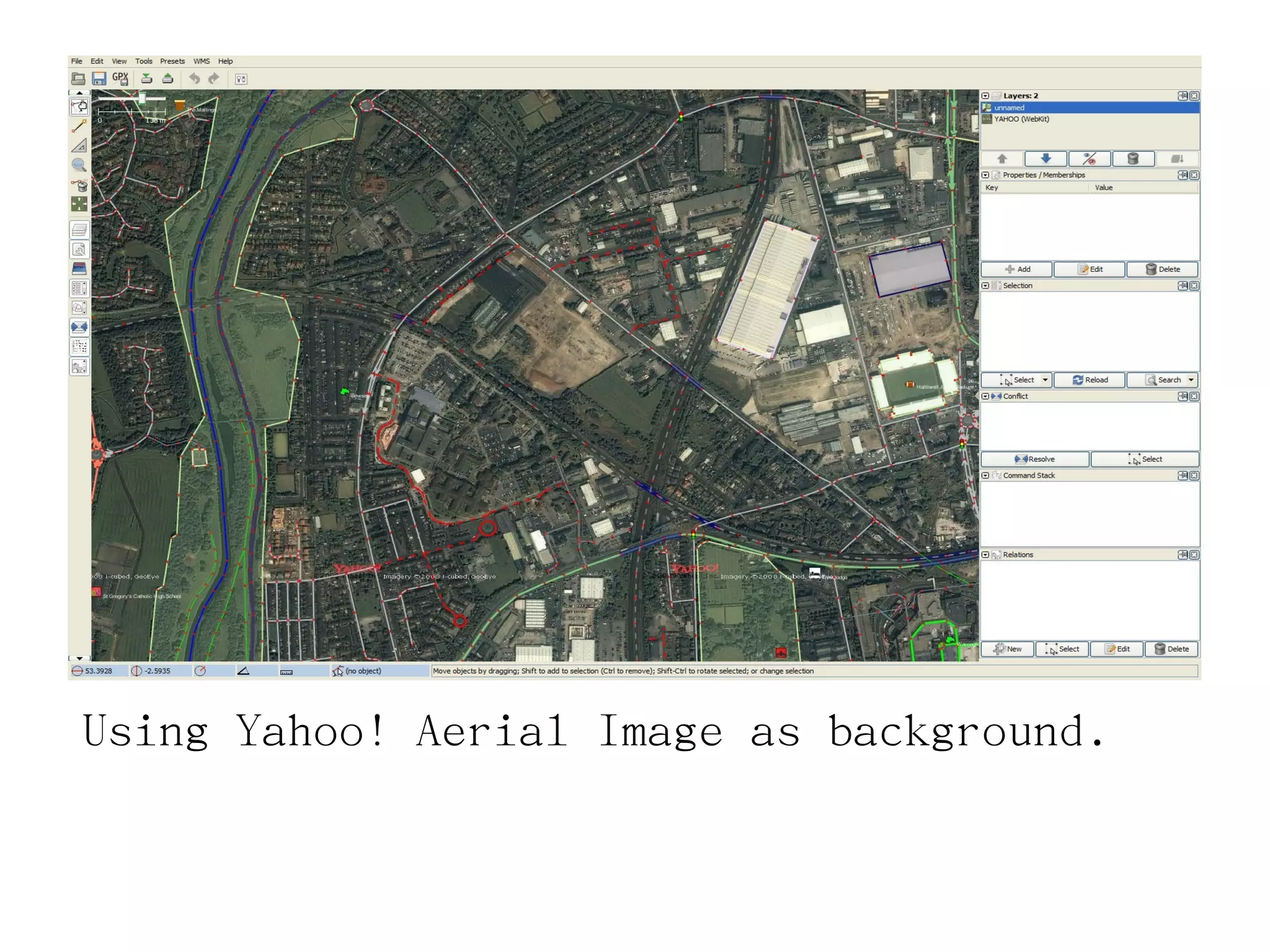
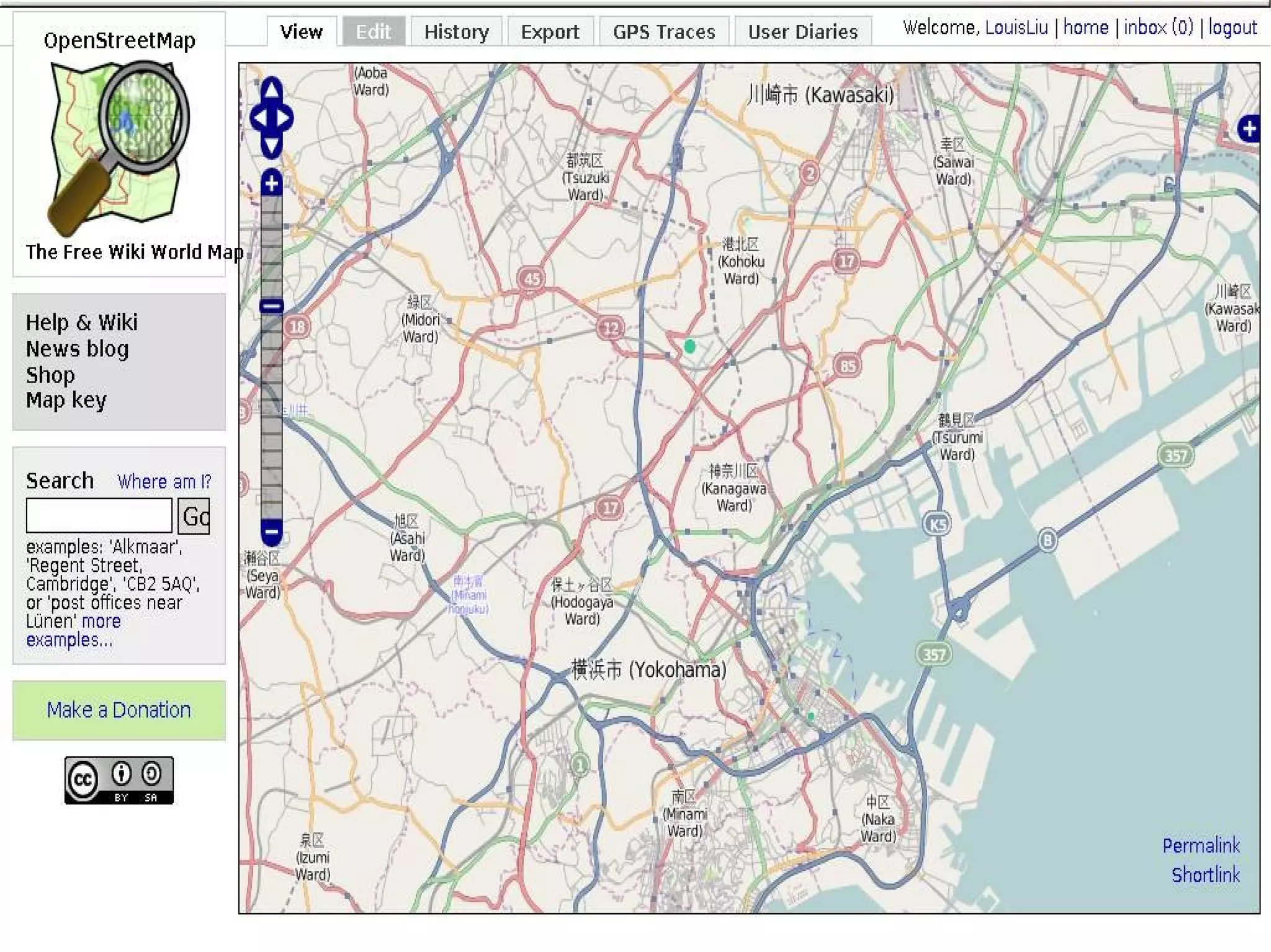
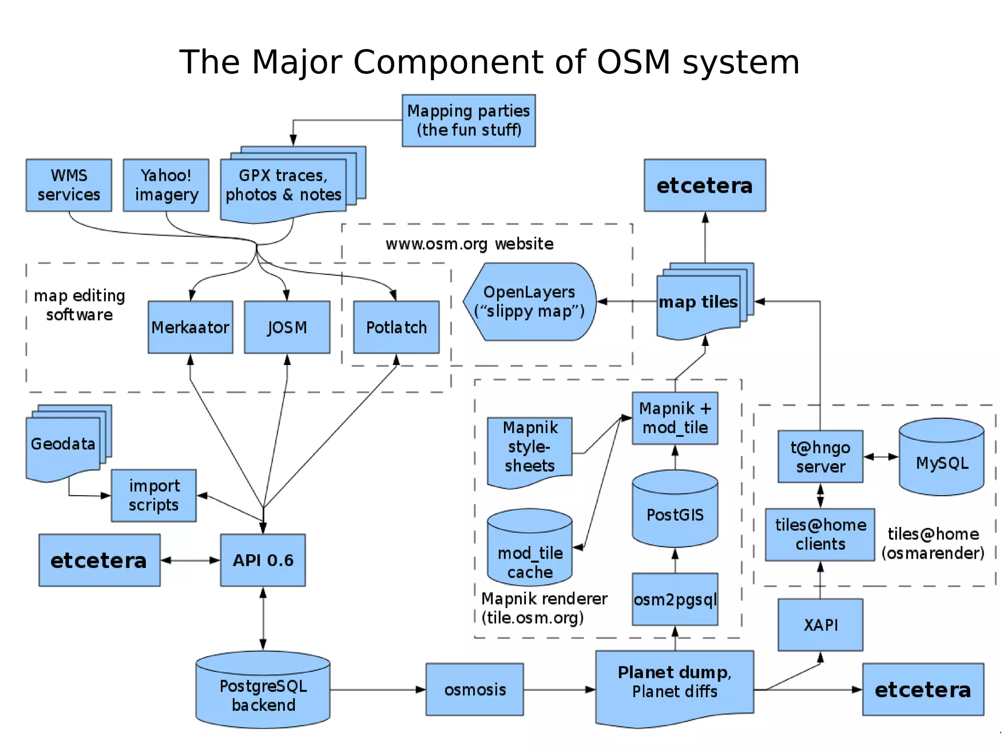
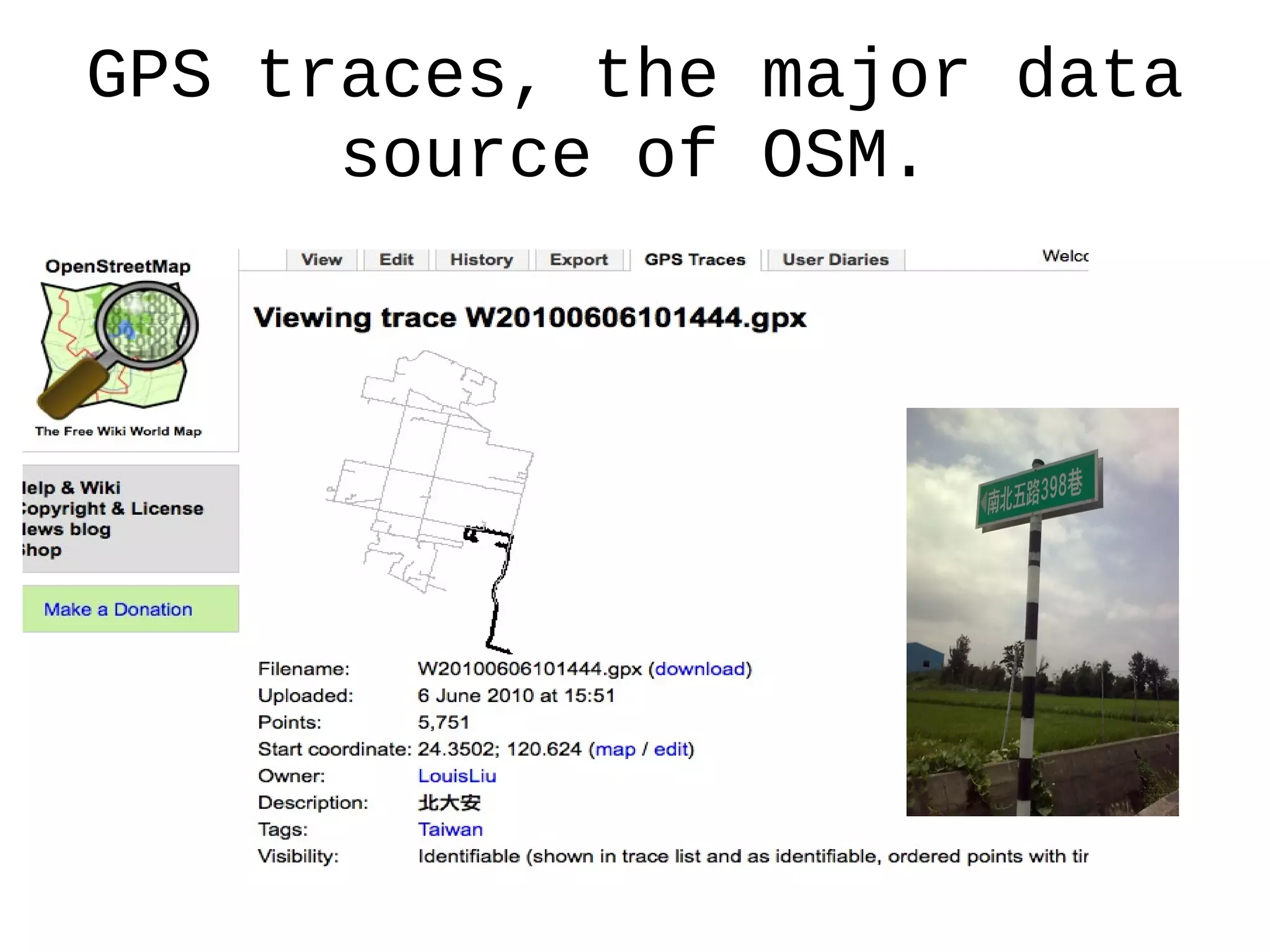
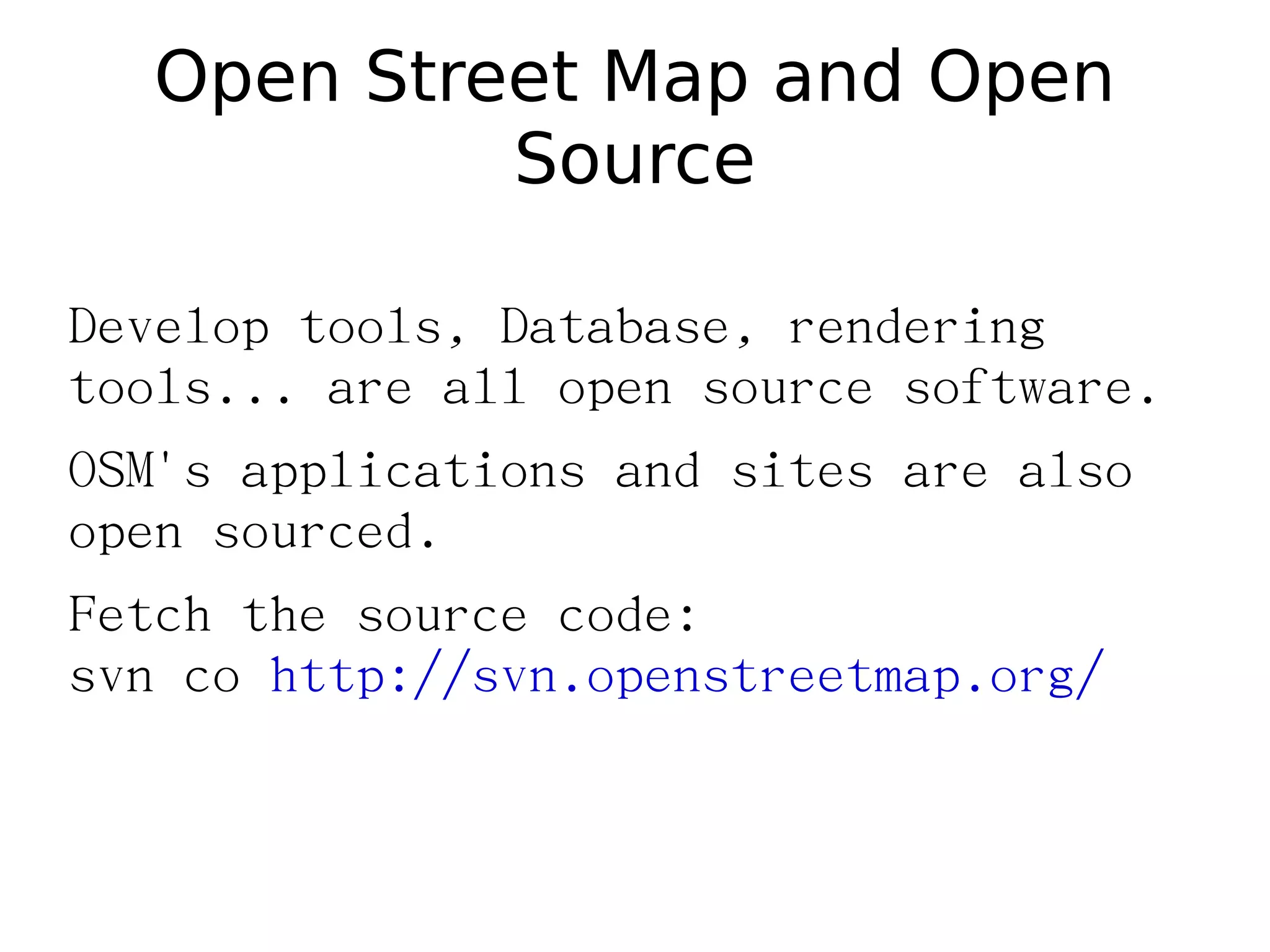
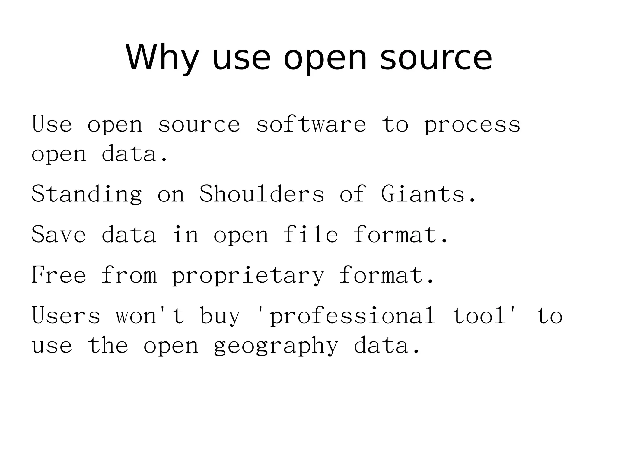
OpenStreetMap (OSM) is a collaborative project to create a free editable map of the world. Users can add and edit map data by uploading GPS traces or extracting information from other sources like aerial imagery. This data is stored in a central database and can be viewed and edited by anyone on a web map or using desktop editors. The map is rendered from the database using open source tools and can be used freely under an open license. Developers contribute by improving the tools, database, rendering system, and applications that make up the OSM project.
Implementation and Design of High Speed FPGA-based Content Addressable Memoryijsrd.com
CAM stands for content addressable memory. It is a special type of computer memory used in very high speed searching application. A CAM is a memory that implements the high speed lookup-table function in a single clock cycle using dedicated comparison circuitry. It is also known as associative memory or associative array although the last term used for a programming data structure. Unlike standard computer memory (RAM) in which user supplies the memory address and the RAM returns the data word stored in that memory address, CAM is designed in such a way that user supplies data word and CAM searches its entire memory to see if that data word stored anywhere in it. If the data word is found, the CAM returns a list of one or more storage address where the word was found. This design coding, simulation, logic synthesis and implementation will be done using various EDA tools.
This document lists several community amenities located in Mount Roskill, including the library, tennis courts, a gym, athletic grounds, a community cafe, and a swimming pool. It also notes that a market is held on Tuesdays and Fridays in the area.
Event Visualization with OpenStreetMap Data, Interdisciplinary ProjectBibek Shrestha
This document describes an interdisciplinary project to visualize events using OpenStreetMap data. It discusses how OpenStreetMap's database structure was copied and extended to collect event information using custom tags. A JOSM plugin was created to simplify data entry. An OpenEventMap web application was built to extract, structure, and visualize the event data on a map. It allows users to search for events by parameters like name, category, and date. The document outlines the OpenStreetMap technology stack, including the Rails Port application and Postgres database, and how it was configured for this project.
OSM is a collaborative project to create a free editable map of the world. Kosovo needs up-to-date and accurate maps for many reasons like tourism, commerce, and navigation. Local volunteers have been working to map Kosovo using tools like GPS devices, aerial imagery, and old military maps to contribute data to OSM. This open data can then be used freely by many different applications and services.
A look at the various open source/open data options for an open maps stack - OpenStreetMap, OpenLayers, etc. Also goes into a bit more detail on the Mapstraction library.
The document discusses plans to improve OpenStreetMap data in the Portland, Oregon region by making OSM street linework coincide with an existing dataset, adding additional linework like trails and paths, and verifying directionality and turn restrictions for bicycle routing. The work will be conducted in phases, with an initial focus on geometry improvements, then adding turn restrictions for driving. Student interns and local OSM experts will help complete the work, which aims to create a more accurate open street map for trip planning applications.
OpenGeoData Italia - Roma - Simone Cortesi | Maurizio Napolitano | openstreet...Simone Cortesi
Discussione su OpenStreetMap, sistemi GIS classici, confronti, potenzialità di OSM e dei suoi strumenti di estrazione dati.
Slide per la conferenza OpenGeoData Italia - Roma - 27 febbraio 2014.
Mappetizer "Tourist Info", "City Info", and "Travel Diary" are SVG based web mapping applications, which directly can display GPS data (GPX files).
This document provides definitions and terminology related to producing General Transit Feed Specification (GTFS) data from geospatial vector data. It discusses stops, routes, trips, shapefiles, coordinate reference systems, QGIS, PostgreSQL/PostGIS, and the shp2GTFS tool. The document outlines how to use these tools and technologies to create GTFS feeds from shapefile data in QGIS, store the data in a PostgreSQL/PostGIS database, and convert it to GTFS format using the custom shp2GTFS Python script.
This document provides an introduction to data collection and the General Transit Feed Specification (GTFS). It defines key terms like stops, routes, trips, and shapefiles. It discusses tools used like QGIS, PostgreSQL, PostGIS, and the shp2GTFS Python script for converting shapefile data to GTFS format. The document outlines the basic usage of these tools for collecting transit network data in layers and shapefiles using QGIS, storing it in a PostgreSQL/PostGIS database, and converting it to GTFS format.
OpenStreetMap (OSM) is a collaborative project to create a free editable map of the world. It was founded in 2004 and now has over 500,000 registered users. Data is collected through GPS, local knowledge, and correcting existing maps. The map can be edited online or through applications like JOSM and uploaded. OSM data includes nodes, ways, closed ways, and relations. Rendering transforms the vector data into a more artistic map. OSM has benefits like aiding disaster relief and is compatible with platforms like Ushahidi.
Osmose is a quality assurance tool for OpenStreetMap that has been running since 2008. It consists of backend analyzers that process OSM data to detect errors, and a frontend website that displays errors to contributors. The analyzers check for issues like unclosed areas, invalid tags, and inconsistencies. Errors are categorized and can be viewed on a map. Osmose integrates data from sources like OpenData and Wikipedia to help validate features. It runs regularly on different regions to identify new errors and track fixes over time.
Webinar presentation for the GIS course held by Professor Maria Brovelli at Politecnico di Milano. As a PoliMappers officer, I introduced the attendants to the project of OSM, highlighting its main idea and concepts.
Working with OpenStreetMap using Apache Spark and GeotrellisRob Emanuele
The document discusses OpenStreetMap (OSM) and OSMesa, a framework for distributed processing of OSM data. It describes the OSM data model including nodes, ways, relations, and tags. It then discusses a use case where OSM change history needed to be processed at scale to backfill missing maps statistics. OSMesa was developed to handle this using Apache Spark and GeoTrellis on AWS. It can generate vector tiles, statistics, and other outputs from the full OSM history dataset in an efficient distributed manner. The future of OSMesa includes improved validation workflows, machine learning applications, and data science on OSM data.
An introduction to GIS Data Types. Strengths and weaknesses of raster and vector data are discussed. Also covered is the importance of topology. Concludes with a discussion of the vector-based format of OpenStreetMap data.
The document discusses MVP OSM, a tool that allows users to identify areas of high activity on OpenStreetMap based on the level of detail. It summarizes how MVP OSM works by importing OSM data into a Spatialite database, analyzing user contributions to identify the most active ("valuable players"), and generating heat maps of activity hotspots. The tool could help recognize highly engaged mappers and understand patterns of contributions on OSM.
The document provides an overview of the ArcGIS Editor for OpenStreetMap (OSM). It discusses:
1) The desktop and server components that allow editing OSM data in ArcGIS and creating feature services from OSM data.
2) Key features like downloading global OSM data, creating a large geodatabase, network analysis tools, and uploading edits back to OSM.
3) Effective usage cases like contributing existing datasets to OSM, using ArcGIS tools for analysis and editing, and creating custom services from OSM data.
4) Examples of using the tools for crisis analysis and updating maps of power lines and hiking trails.
OpenLayers (OL) is an open-source JavaScript library for displaying map data in web applications. It can display data from various sources like GeoJSON, WMS, WFS and supports interactions like querying, filtering and overlaying layers. OL has evolved over the years with new versions introducing features like improved projections support, 3D rendering and compatibility with modern standards. While Leaflet is better for simpler uses due to its large plugin ecosystem, OL is more powerful and flexible for complex GIS applications and supports advanced OGC protocols out of the box.
Leo Hsu and Regina Obe
We'll demonstrate integrating PostGIS in both PHP and ASP.NET applications.
We'll demonstrate using the new PostGIS 1.5 geography offering to extend existing web applications with proximity analysis.
More advanced use to display maps and stats using OpenLayers, WMS/WFS services and roll your own WFS like service using the PostGIS KML/GML/and or GeoJSON output functions.
Humanitarian OpenStreetMap Team [H.O.T.] Training for SBTFStandby Task Force
OpenStreetMap is a collaborative project to create a free editable map of the world. It began in 2004 and now has over 1 million users who have collected over 1.8 billion geographic points and 170 million roads through GPS, aerial imagery, and other sources. The OpenStreetMap Foundation and Humanitarian OpenStreetMap Team support the growth of OSM for humanitarian and development contexts. Users can contribute geographic data by tracing imagery, surveying with GPS, or importing public domain data. The data is represented as nodes, ways, and relations which can be tagged and mapped on various online and mobile applications. Studies have found OSM data to be as accurate as commercial datasets where there is significant community mapping activity.
The main focus of this study is to find appropriate and stable solutions for representing the statistical data into map with some special features. This research also includes the comparison between different solutions for specific features. In this research I have found three solutions using three different technologies namely Oracle MapViewer, QGIS and AnyMap which are different solutions with different specialties. Each solution has its own specialty so we can choose any solution for representing the statistical data into maps depending on our criteria’s.
Design the implementation of Anytime D Star on an Occupancy GridAnkita Tiwari
This experiment aims to study and design the implementation of Anytime D Star path planning on an occupancy grid. The experiment uses LabVIEW to create a main VI that uses the Anytime D* search algorithm to calculate a suboptimal path quickly and then update the path in subsequent executions until an optimal path is found. Sub-VIs are used to generate random obstacles, check valid cells, convert paths to the grid, and reveal portions of the world. The results show that the VI can plan paths efficiently using information from previous iterations to handle changes in the robot's environment or goal.
1) MapQuest has ingested OSM data into their routing engine and is deploying sites in Europe using OSM routing data. They plan to offer similar services for routing in the US using OSM data after improvements are made.
2) MapQuest is working on improving OSM data quality within the US by identifying issues, developing tools for fixing problems, and partnering with OSM contributors.
3) Their goals include making pedestrian routing enhancements, associating real-time traffic data with OSM, and continuing to optimize their routing engine for high performance when using OSM data.
OpenStreetMap is a collaborative project to create a free editable map of the world. It began in 2004 and now has over 1 million users contributing data. The Humanitarian OpenStreetMap Team contributes mapping data for humanitarian and development contexts. OpenStreetMap data can be used for routing, downloaded for use in other projects, and edited in apps or through the website. Analysis has shown the positional accuracy of OpenStreetMap data is around 6 meters where there is significant contributor activity and quality assurance.
This document provides information on setting up a development environment for Sahana Eden, including installing required software, recommended editors and debuggers, and guidelines for customizing and extending Eden through its model-view-controller architecture. Key steps include installing Python and dependencies, configuring the database, using Git for version control, and developing new modules by defining models, controllers, and views.
This document discusses deploying the Sahana Eden disaster management system. It provides guidance on project planning, deployment options on laptops, servers or cloud platforms, hardware requirements, installation processes, configuration settings, customization for local needs, and testing and maintenance procedures.
Sahana Eden is an open source disaster management software platform that is highly configurable, easy to modify, and has flexible data sharing and import/export options. It can be used across the disaster management cycle of mitigation, preparedness, response and recovery. Sahana Eden has been used by organizations like the Red Cross, UN World Food Programme, and governments. It offers features like incident tracking, dispatching, asset management, data collection/sharing, and integration with GIS mapping.
Bombeiros Workshop - Introduction to Sahana EdenAidIQ
Sahana Eden is an open source disaster management software platform that is highly configurable, easy to modify to build custom solutions, and free to use without restrictions. It includes modules for resource management, human resources, vehicles, assets, incident tracking, dispatch, and situational awareness. Key features include human resources management, asset management, incident tracking where details are immediately visible across command centers, dispatch capabilities to assign vehicles and people, and in-field communications.
Humanitarian Mapping - Sahana and OpenStreetMapAidIQ
Sahana and OpenStreetMap provide humanitarian mapping tools to help relief organizations in disaster response. Sahana's platform includes tools for situation awareness, decision support, and rapid application development using open standards and open source software. It allows field teams to share GPS information, including offline, and features mapping capabilities like importing overlays from sources like OpenStreetMap, KML, and GPX files.
Sahana Eden : Introduction and Simulation A (SahanaCamp 1.2)AidIQ
SahanaEden is open-source disaster management software that provides applications like inventory management, incident reporting, and project tracking to support decision making during disasters. It has been used since 2005 for events in Sri Lanka, Pakistan, New York City, the Philippines, Haiti, and Pakistan. The software is supported by organizations like the Sahana Software Foundation, IBM, Google, universities, and CrisisCommons.
Sahana Eden : Developer Environment (VM) (SahanaCamp 1.2)AidIQ
This document provides an overview of setting up a developer environment for Sahana Eden using a virtual machine, which contains Python libraries, Web2Py, Sahana Eden, Eclipse, and Firefox with Firebug. It explains running Sahana Eden by launching Eclipse and debugging, then refreshing the browser to register after editing the 000_config.py file. The document also briefly describes the model-view-controller framework of Sahana Eden with models defining database tables, controllers handling workflow and logic, and views containing HTML/JS templates parsed server-side and JS functions run client-side.
This document provides guidance on setting up and deploying Sahana Eden, an open-source disaster management system. It discusses options for deployment on a laptop or server, and steps for server installation including installing software, configuring settings, and setting up security. It also covers ongoing administration tasks like scheduled tasks, updates, and maintaining separate test and production instances.
The document provides guidelines for reporting bugs in Sahana Eden, an open-source disaster management system. It explains that bugs should be reported to communicate issues to programmers so they can be fixed. Reporters are instructed to check if a bug has already been reported, and to provide clear details when submitting a new report, including steps to reproduce, expected and actual results. Bugs are then tracked on the system's reporting site until resolved.
Sahana was used in several disaster response efforts:
- In Haiti (2010) it managed missing persons, maps, organizations and hospitals. It also powered a food request portal for the WFP.
- In Pakistan floods (2010) it implemented new models and features but faced challenges with lack of baseline data, translation and SMS infrastructure.
- In Veracruz, Mexico (2010) setup went smoothly and ownership of the data was given to local organizations, while infrastructure support was provided.
- It also developed a portal to coordinate DRR projects for disaster preparedness organizations.
The document discusses participatory programming which involves engaging local communities in the development of software projects designed to impact their lives. Participatory programming has several objectives including prolonging project impact, making projects more relevant, enhancing effectiveness, establishing relationships, making projects more responsive, increasing available resources, and improving efficiency as participants learn new skills. Both community development and software development use technical skills to solve complex real-world problems. The document asks who should participate in participatory programming and lists potential roles including users, administrators, requirement gatherers, translators, managers, testers, document writers, deployers, and software developers. It also discusses how to engage the community in participatory programming.
OpenStreetMap is a collaborative project to create a free editable map of the world. It allows users to add and edit mapping elements like points of interest, roads, and boundaries. The document outlines OpenStreetMap's copyright policy and describes tools like JOSM, OSMAnd, and Potlatch that allow offline and online editing of map elements and features on desktop and mobile. It encourages participants to sign up, navigate to Hanoi in Vietnam, make small edits by adding missing information, and save changes to the collaborative map.
OpenStreetMap is a collaboratively edited map where volunteers can add and edit mapping data to build a free editable map of the world. It allows for free-form tagging and developing new tags and renderings, unlike Google Maps which has restrictive licensing. OpenStreetMap was quickly used to map Port-au-Prince after the 2010 Haiti earthquake using satellite imagery and old printed maps. The Humanitarian OpenStreetMap Team provides mapping support for disasters and vulnerable communities around the world. OpenStreetMap data can also be used offline on devices and local servers to save bandwidth in areas with limited internet access.
Army helicopters are transporting NGO teams to assess disaster incidents based on reports and assign them to the appropriate NGO. Teams can create assessments from the incident reports, assuming 4 people per household. The gap map and report can be used to visualize needs and plan response activities, considering working in a single cluster or geographical area. Teams should request needed items to support assessment and response activities.
Several locations in Vietnam called Trung Trạch, Tân Trạch, Thượng Trạch, Lâm Trạch, Phúc Trạch, Hải Trạch, and Xuân Trạch have experienced flooding that has destroyed crops and houses, polluted wells, and created health risks by affecting water supplies. Food, shelter, seeds, and medical assistance are urgently needed.
Implementing IT Solutions for Disaster Management (SahanaCamp 1.2)AidIQ
This document outlines the challenges and best practices for implementing IT solutions for disaster management. Some key challenges include uncertain and changing conditions during disasters, communication gaps between organizations and IT providers, and limited time and resources. The document recommends engaging end users during all stages of the software development cycle, from initial requirements gathering to ongoing support. It emphasizes listening to users, testing software early and often with users, and providing training that is interactive and collects feedback to ensure the IT solutions meet real user needs and create value for them.
The document outlines an agenda for a training workshop on Sahana, an open source disaster management system. Participants will be introduced to concepts of disaster management and information systems, learn how to use Sahana's software features, and discuss best practices for implementing information management systems and participatory programming approaches. Practical sessions include simulations and case studies to demonstrate Sahana's capabilities as well as guidance on planning information management system projects.
BZR & LaunchPad : Sharing Your Work With Others (SahanaCamp 1.2)AidIQ
This document provides instructions for using Bazaar (bzr) version control and Launchpad to share work with others through distributed version control. It explains how to set up branches on Launchpad, push and pull from branches, merge changes, resolve conflicts that occur during merging, and subscribe to branches of interest. The goal is to allow developers to work on their own branches while also keeping them in sync with a main trunk through regular merging of updates.
Sahana Eden : Introduction to the Code (SahanaCamp 1.2)AidIQ
This document provides an introduction and overview of how to build an application in Sahana Eden using the Web2Py framework. It covers the Web2Py execution model, using S3 REST controllers, defining models and tables in the database, adding custom views, and enabling a new module. The goal is to build a simple Vehicle Tracking System application to demonstrate these concepts. Key steps include defining a vehicle resource table in the model, adding a REST controller to manage vehicles, and customizing views and navigation to interact with vehicles.
3. OpenStreetMap (OSM) follows a similar
concept as Wikipedia does, but for maps
and other geographic facts.
This information then gets uploaded to
OpenStreetMap's central database from
where it can be further modified,
corrected and enriched by anyone who
notices missing facts or errors about the
area.
4. Anyone can freely download and use the
full information for any purpose they like
under an open source license.
7. Slippy Map, the map viewer.
Potlatch, the online map editor.
Export, export map data to xml data, image, or
embedded html.
Mapper system
Account setting, query other mappers'
information, sending/receiving messages,
upload GPS traces, writing diaries...
8. Slippy Map
Base Layer:
Mapnik
The default map.
Osmarender
The alternative map.
Cycle Map
The map for cycling.
NoName
Fine ways without naming.
Overlays
Data
View OSM data and it's edit history.
12. Upload GPS Traces
http://www.osm.org/traces/tag/Taiwan
If you do not want your GPX points to be
seen by anybody else, DO NOT upload
tracks. `
Must be GPX (gziped or flat) file format.
GPX trace file should consist of track points
with valid time stamp.
13. Other data source
Yahoo! Aerial Imagery
Yahoo! have agreed to let OSM use their aerial
imagery for the purposes of tracing.
It is possible to sketch in the road layout for large
expanses of urban areas, without going there.
Cirerone Mapped Taipei with Yahoo! Aerial
Imagery.
Open Aerial Map
The site is currently offline.
14. Convert from other open map data
TIGER
Tiger, Topologically Integrated
Geographic Encoding and Referencing
system data for US streets, produced
by the US Census Bureau, is a public
domain data source.
AND
Automotive Navigation Data donated
the entire streetmap of the
netherlands.
16. Basic Element
Node
Nodes consist of latitude and longitude.
Nodes are needed to define a way, but a node can
also be a stand alone unconnected point.
Standalone nodes should always have at least one
Tag.
Nodes forming part of a way open do not have
tags themselves.
17. Way
A way is an ordered interconnection of at least 2
nodes that describe a linear feature such as a
street, railway, river …
Ways should be split into shorter sections if
different properties exist.
Nodes can be members of multiple ways.
Area (Closed way)
Areas are not separate elements, they are merely
closed ways that represent an area.
18. Relation
A relation can group other elements together,
nodes, ways and maybe even other relations.
Relations can be used to represents things like
cycle routes, bus routes, turn restrictions,
boundaries....
19. Tag
A property attached to a node, way, area or
relation.
These properties are Key-Value pairs describing
the element.
20. To ensure that applications and other users
of the OSM data can interpret the tags in a
meaningful way it is recommended but
not required to follow certain tagging
standards documents.
http://wiki.osm.org/wiki/Map_Features
http://wiki.osm.org/wiki/Tw:Taiwan_road_tagging
http://wiki.osm.org/wiki/tagwatch
21. Key Value
highway tertiary
ref TC-26
name Dama Rd.
name:zh 大馬路
is_in Waipu Township,
Taichung County
is_in:zh 台中縣外埔鄉
23. Potlatch
A Flash based online
Map editor, you can
found at “Edit”tab on
home page.
Potlatch is intended as
as an easy-to-learn
editing environment for
drawing ways and
adding metadata to
existing ways.
24. Merkaartor
OSM Editor for UNIX,
Windows and OS X.
Map view near-
WYSIWYG, anti-
aliased, with road
names.
Live connection to
your GPS.
25. JOSM
Java OpenStreetMap Editor
JOSM is a feature-rich editor.
Highly configurable and extensible via plug-
ins.
Can work off-line using download data files.
Work with local photo and GPX files.
It's POWERFUL but Not Easy to learn.
30. OSM API
OpenStreetMap has an API for fetching and
saving from/to OpenStreetMap database.
The API is the server component to which
REST requests are addressed. The REST
requests take the form of HTTP GET, PUT,
POST, and DELETE messages. Any payload
is in XML form, using the MIME type
"text/xml" and UTF-8 character encoding.
31. All of the calls to the API which update,
create or delete data have to be made
by an authenticated and authorized
user. Authentication works by using
HTTP Basic authentication using an user
name and password or by using OAuth.
33. Changesets
To make it easier to identify related changes
the concept of changesets is introduced.
Every modification of one or more of the
elements has to reference an open
changeset.
Changesets are specifically not atomic -
elements added within a changeset will be
visible to other users before the changeset
is closed.
34. Changesets facilitate the implementation of
rollbacks. By providing insight into the
changes committed by a single person it
becomes easier to identify the changes made,
rather than just rolling back a whole region.
35. Current Version is 0.6.
http://wiki.osm.org/wiki/API_v0.6
For testing:
http://api06.dev.openstreetmap.org
36. OSM API Server
The Rails port is the current version of OSM's
server code - API, web front end and everything
that runs on www.openstreetmap.org.
Runs on Unix-like systems.
37. Planet.osm
a snapshot of the OpenStreetMap database.
the latest revision of the nodes, ways, relations
and changesets
an XML formatted .osm file.
http://planet.openstreetmap.org/
Current file size: 8.3GB
(Bzip2 compressed, 2010 04/12)
Extrats: partical area of planet.osm
Osmosis and other tools can handle it.
39. Mapnik
http://mapnik.org/
Mapnik is a open source toolkit for rendering
maps.
OSM uses Mapnik to render 256 × 256 pixels tiles.
Use Postgres as data backend and import osm
data source to db with osm2sql.
A template.xml controls style sheet.
It's need several hours to generate Taiwan nearby
tiles.
40. mod_tile and rendered
An Apache module which is responsible for
requesting tiles.
renderd - A rendering daemon which calls mapnik
and writes the map tiles to the filesystem
If the tiles are already rendered then Apache will
serve them efficiently from the filesystem.
41. Tile@Home
We all heart SETI@Home.
A Distributed tile render system.
There are many people who run the client
software on their computers that ask what map-
tile to render and contribute their results back to
the server.
Osmarender and http://informatinofreeway.org/
uses T@H.
45. wiki.openstreetmap.org
Mediawiki is OSM's document system.
News.
Instructions for Mapping.
License information and other issues.
Development information.
Wiki project pages for mapping different
countries or cities.
References for map features (tags).
A voting system.
46. Contact other mappers
Mail List
OSM-talk, talk-tw, osm-dev......
Send Message
Send message in http//osm.org.
Discussion in wiki's “talk page”
Join local mapper group
Map Party is fun!
47. Open Street Map and Open
Source
Develop tools, Database, rendering
tools... are all open source software.
OSM's applications and sites are also
open sourced.
Fetch the source code:
svn co http://svn.openstreetmap.org/
48. Why use open source
Use open source software to process
open data.
Standing on Shoulders of Giants.
Save data in open file format.
Free from proprietary format.
Users won't buy 'professional tool' to
use the open geography data.
49. To Be A Mapper
Wiki is your friend
Beginner's Guide
Map Features
Editing Standards and Conventions
Mapping techniques
Join local mapper group
50. 2010 08/07 Map Party @Tainan
http://registrano.com/events/b2daeb
51. To Be A Developer
Wiki is your friend
#OSM-dev list.
Read The Find Manual.
Read The Find Source Code.
Observe develop tools' license.
Do NOT break OSM license and policy.
Ask the community for help!