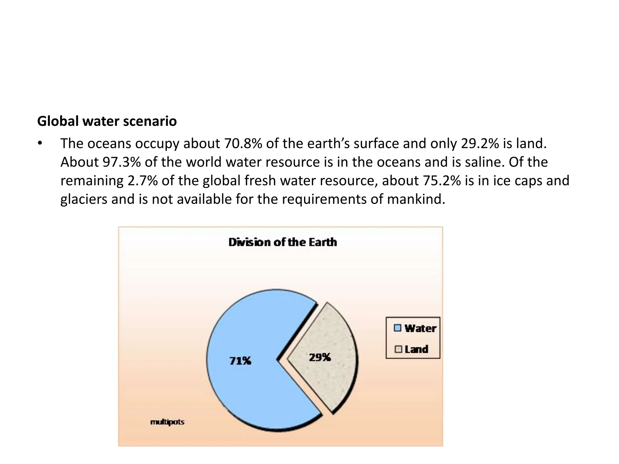
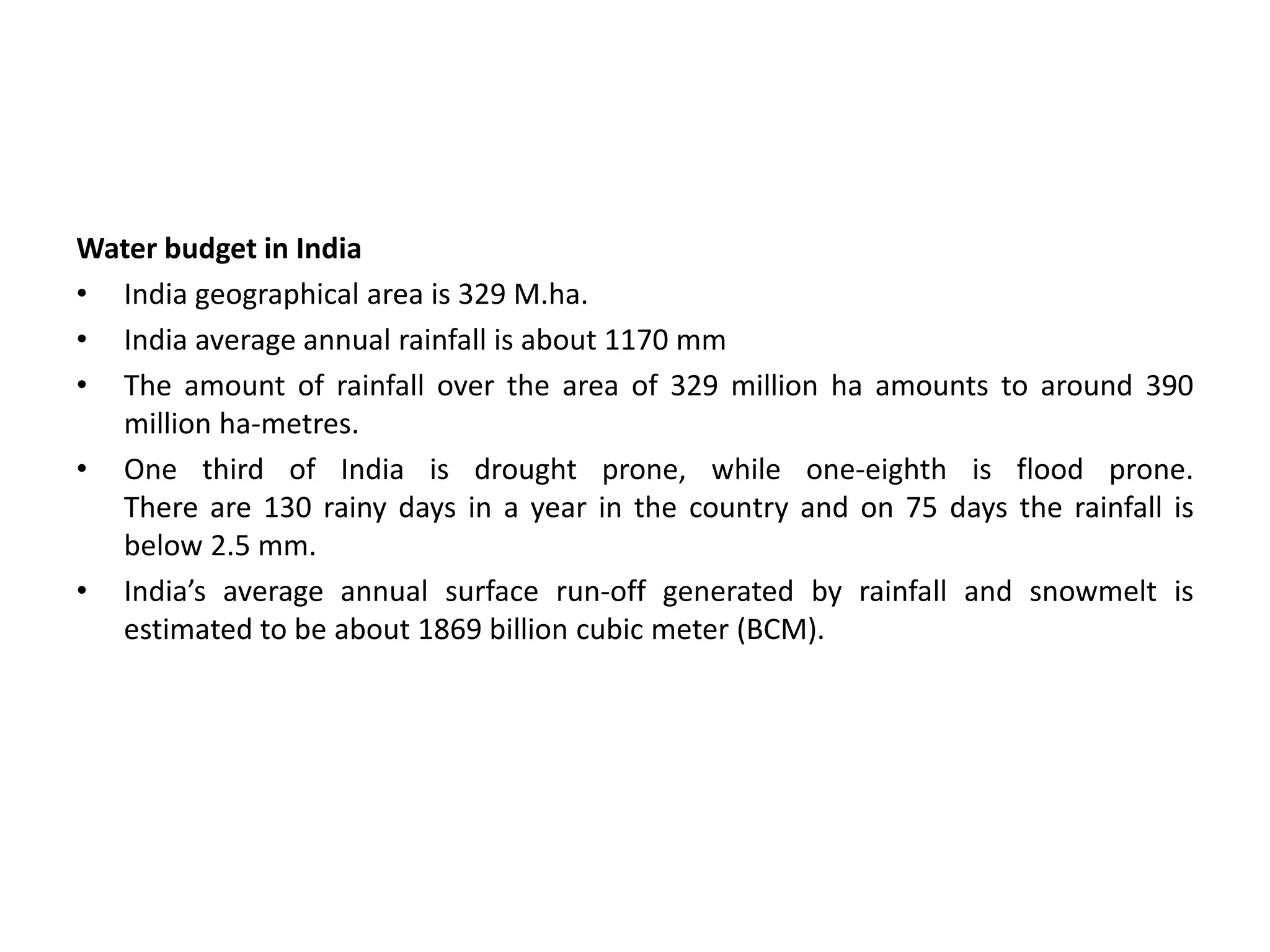
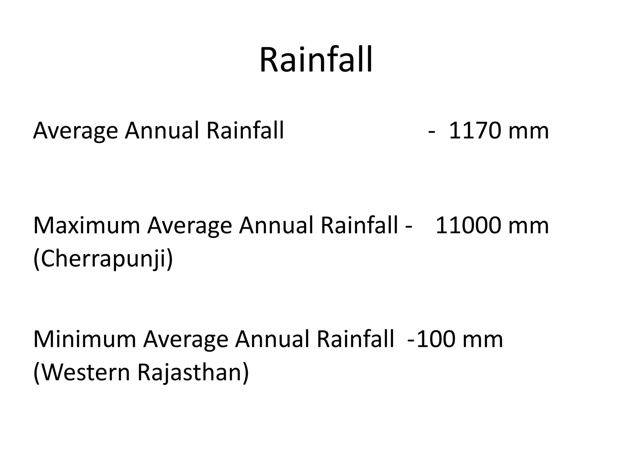
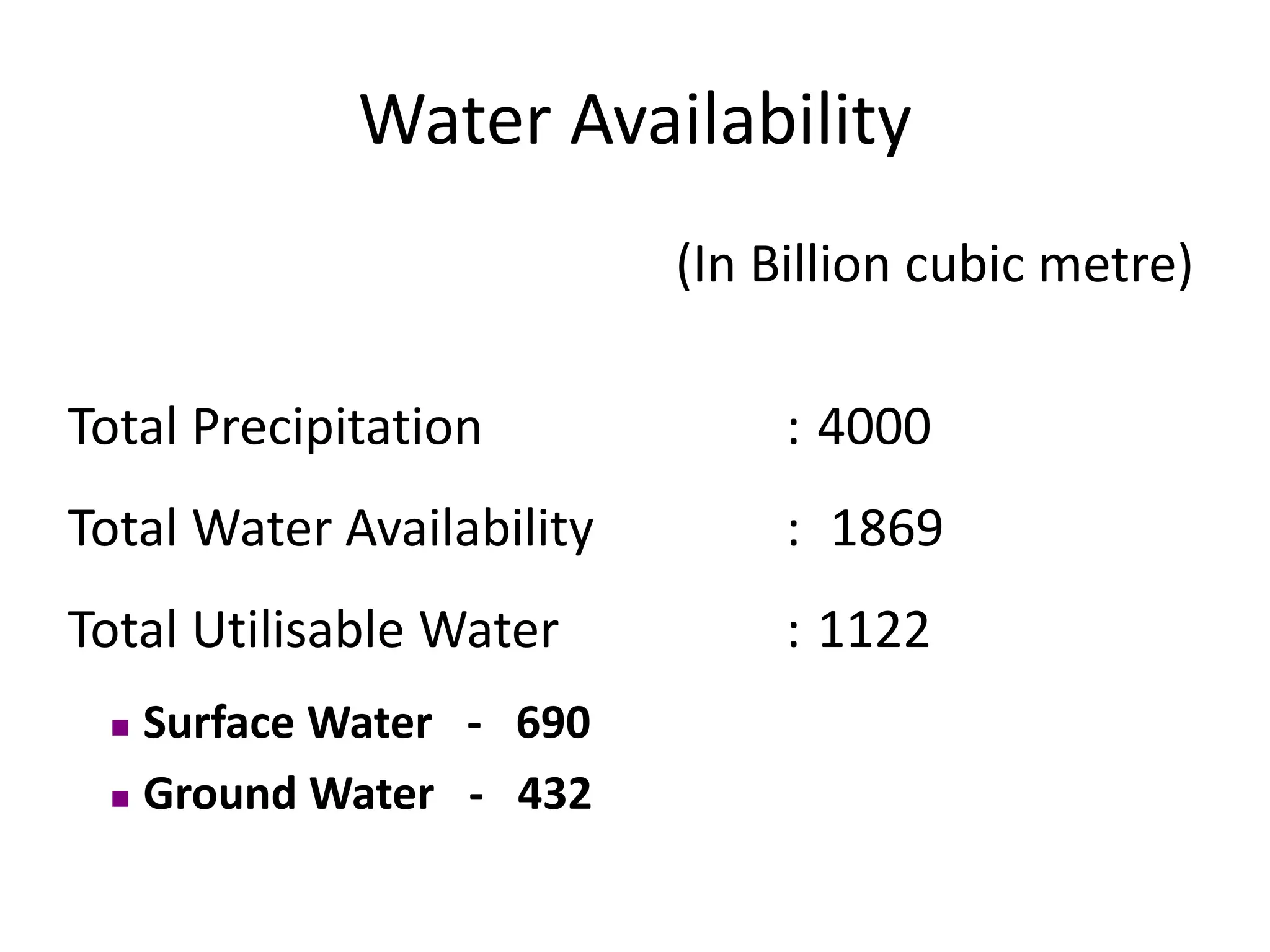
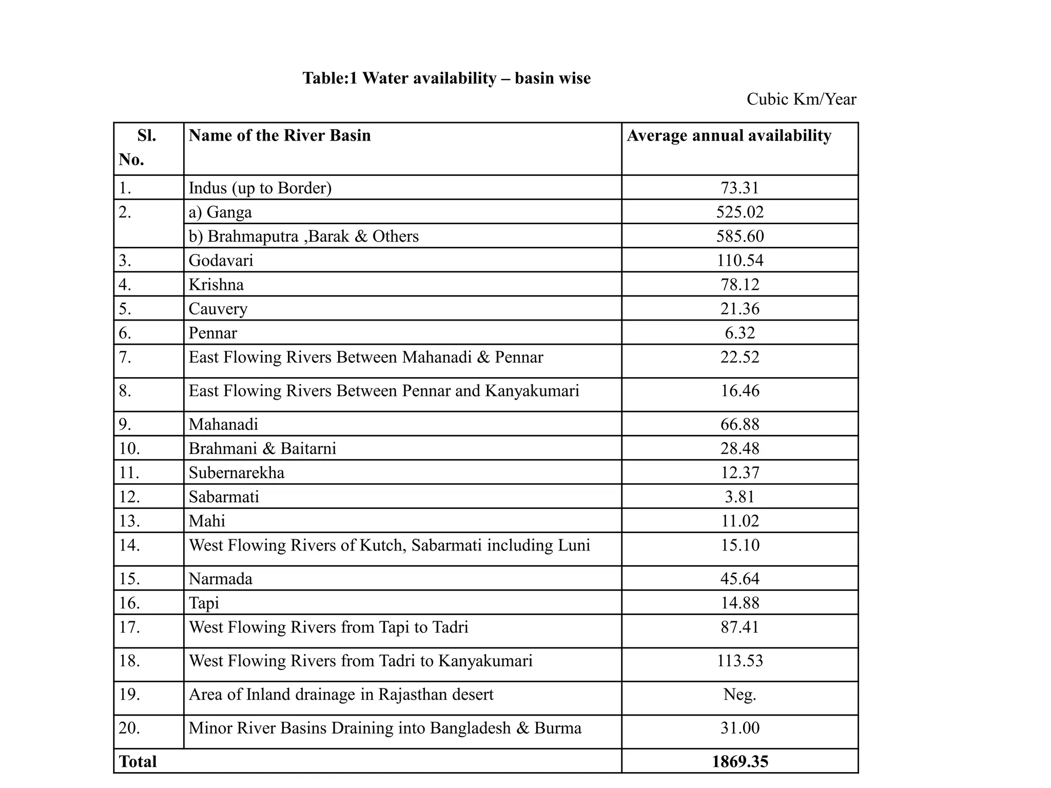
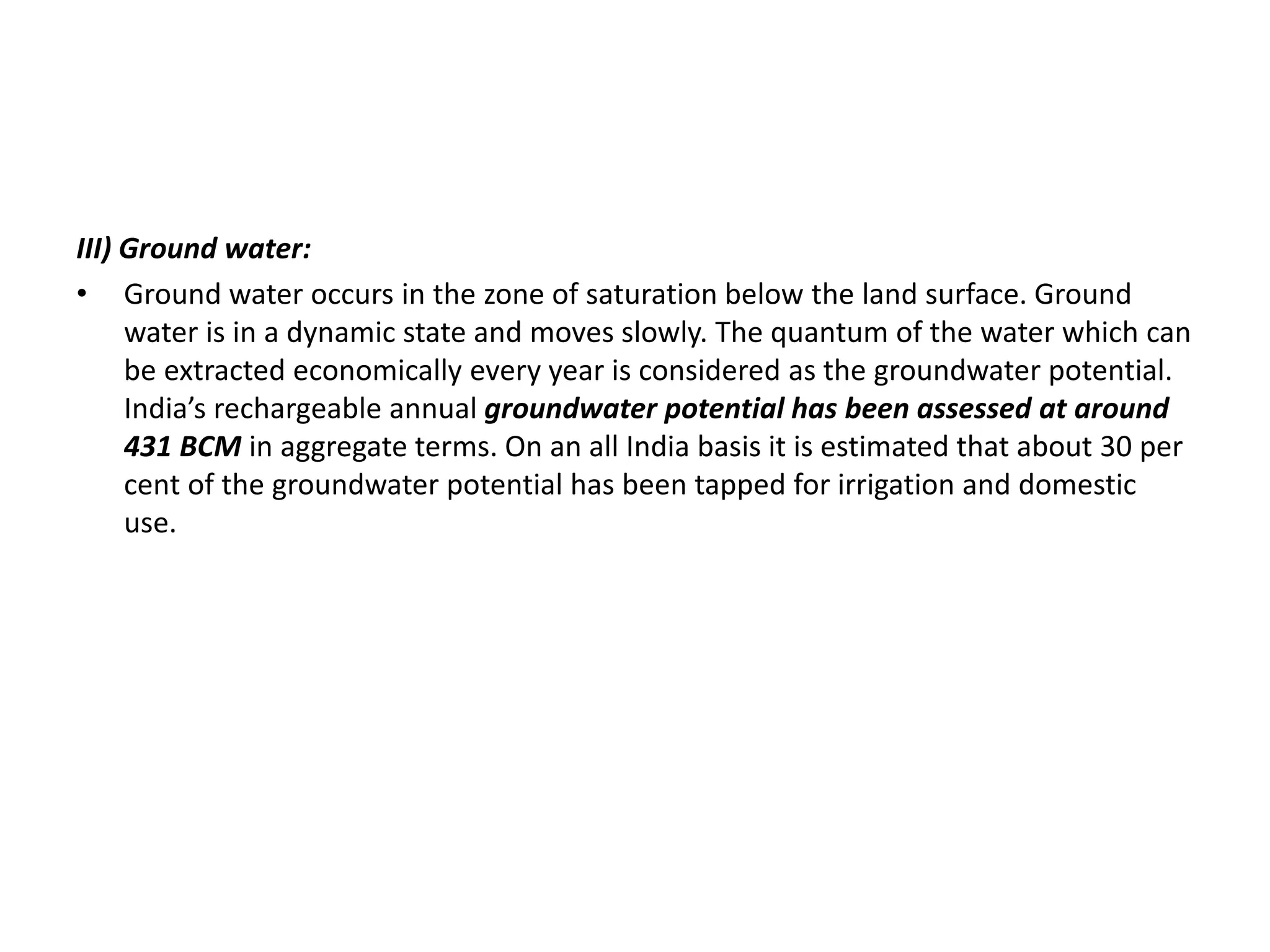
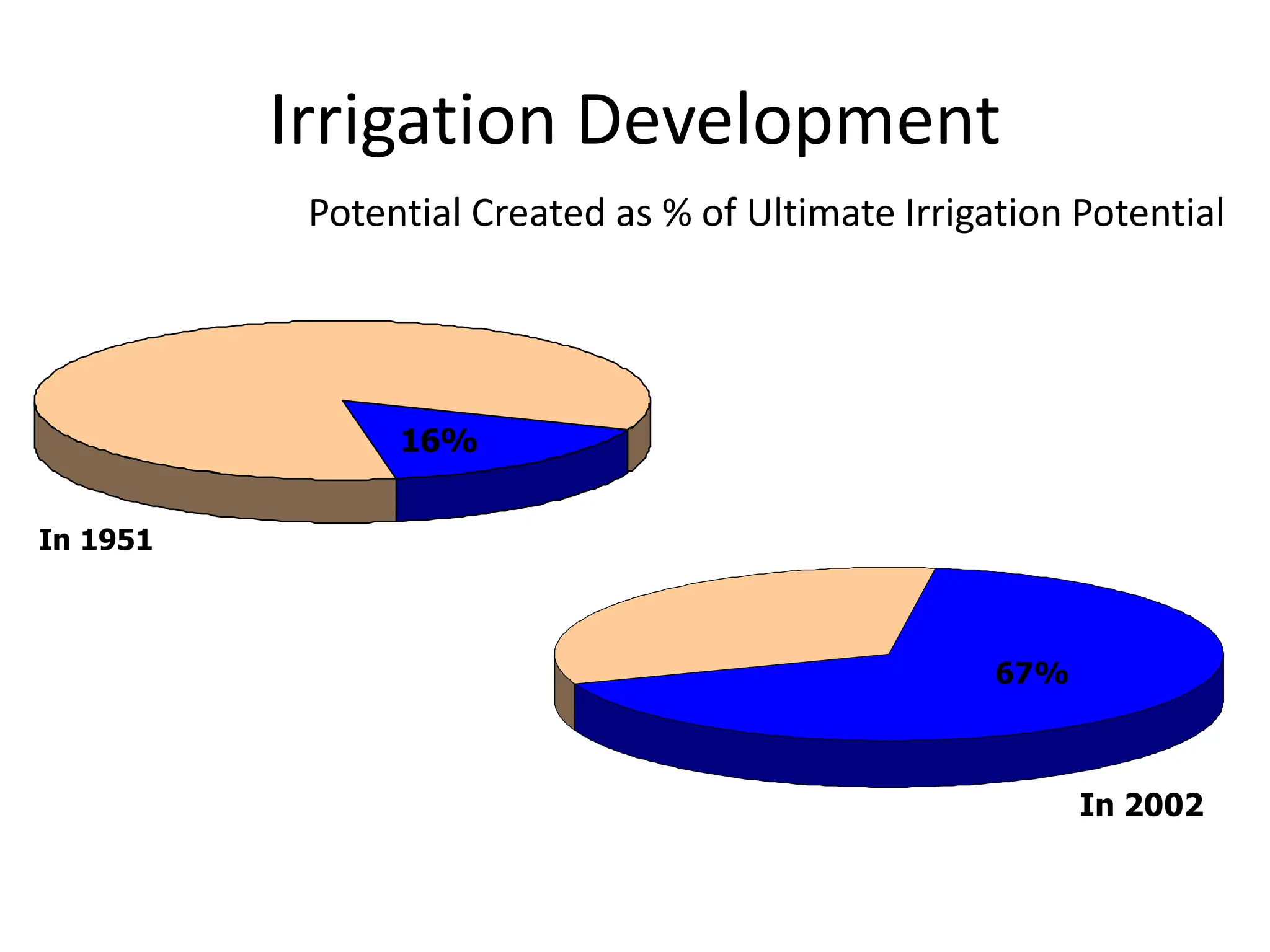
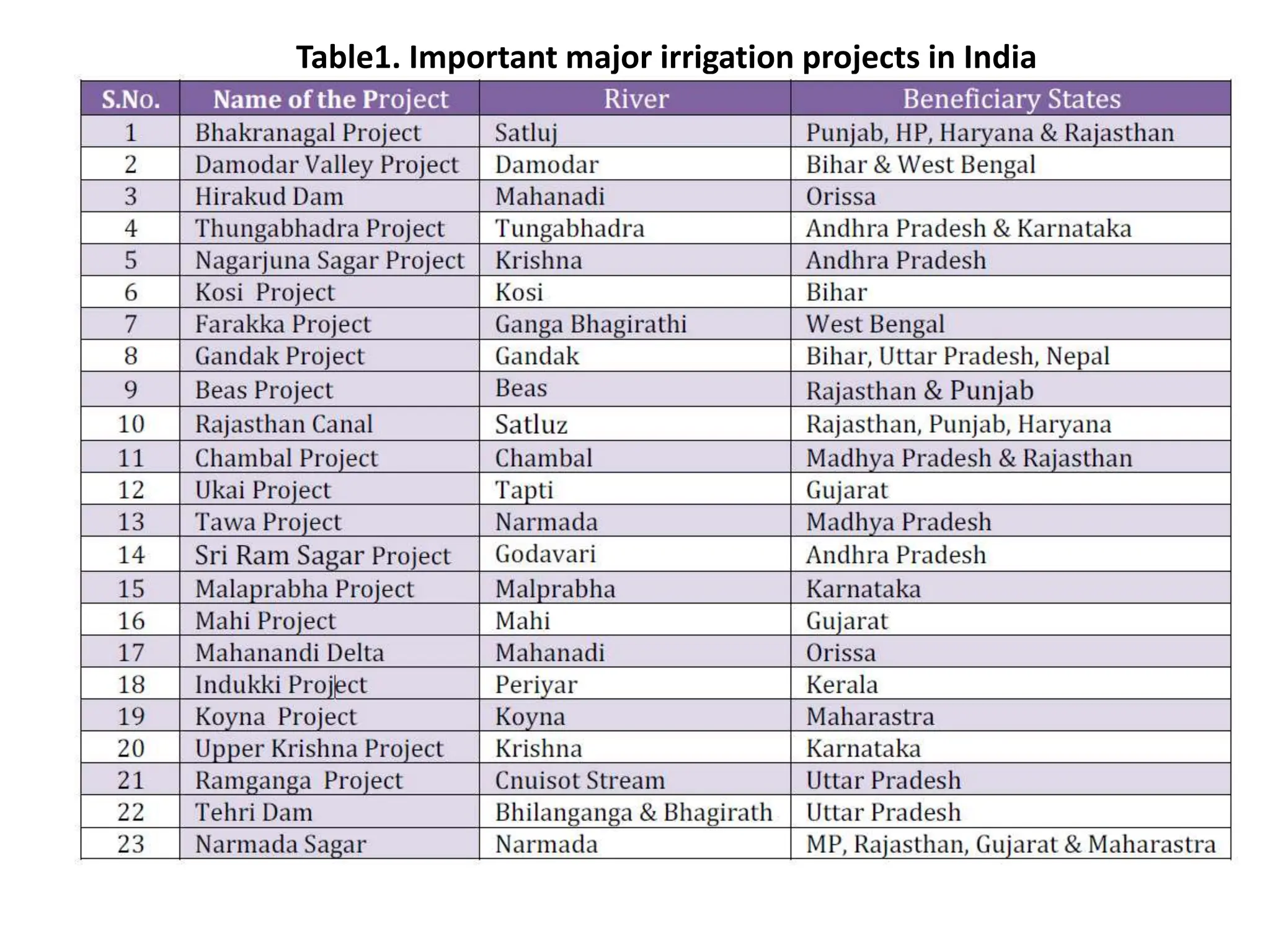
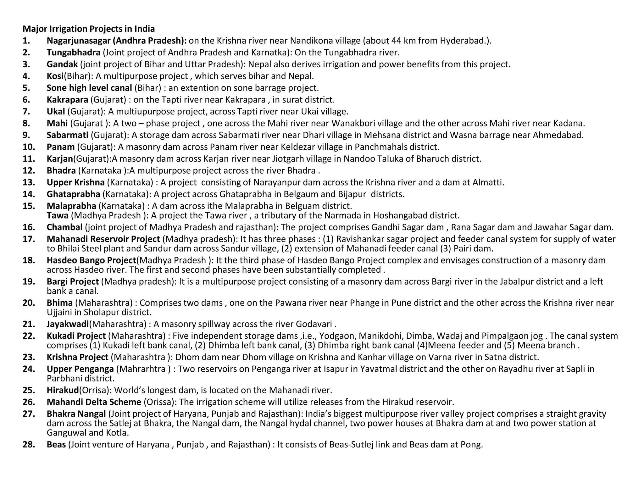
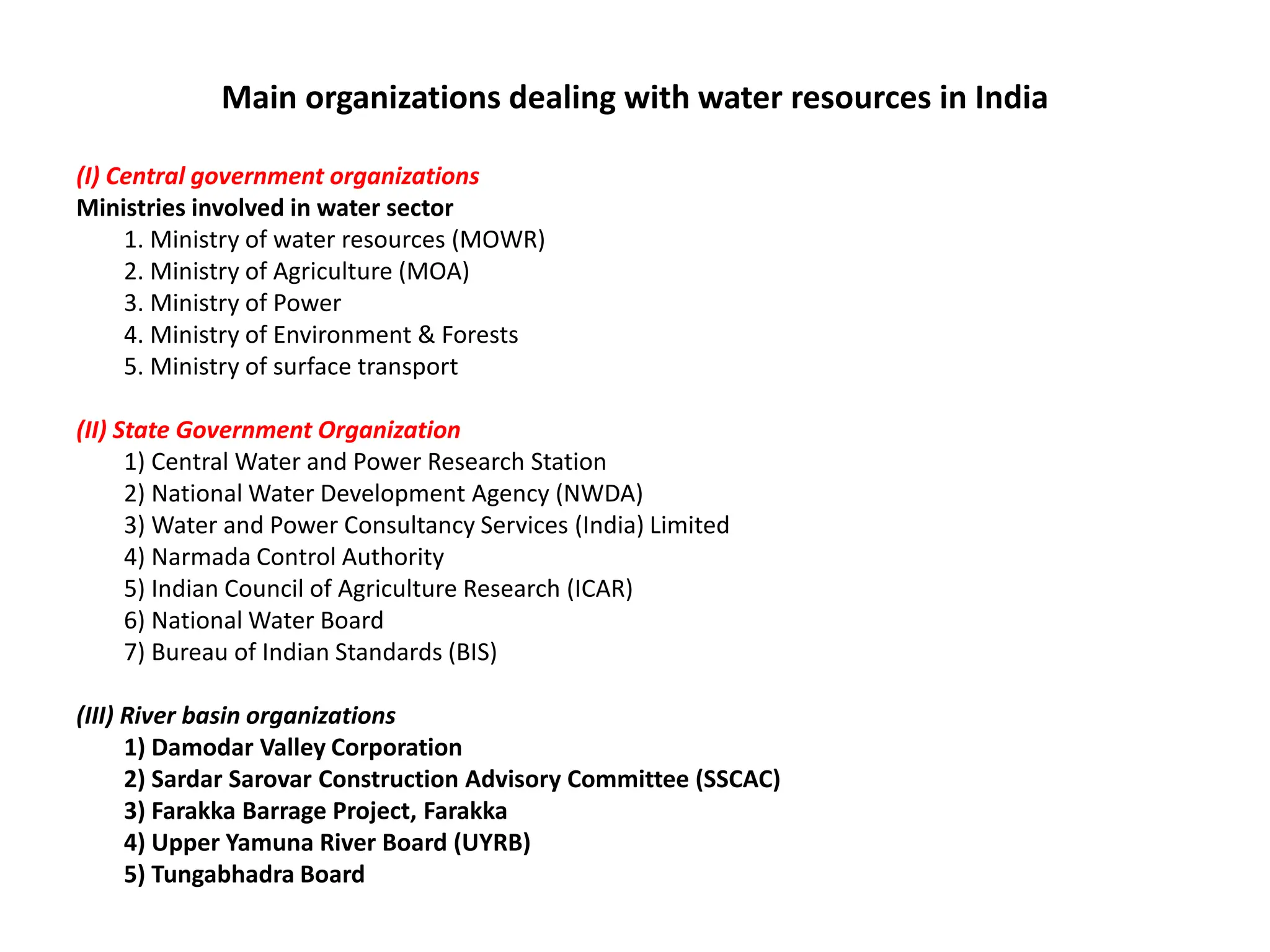
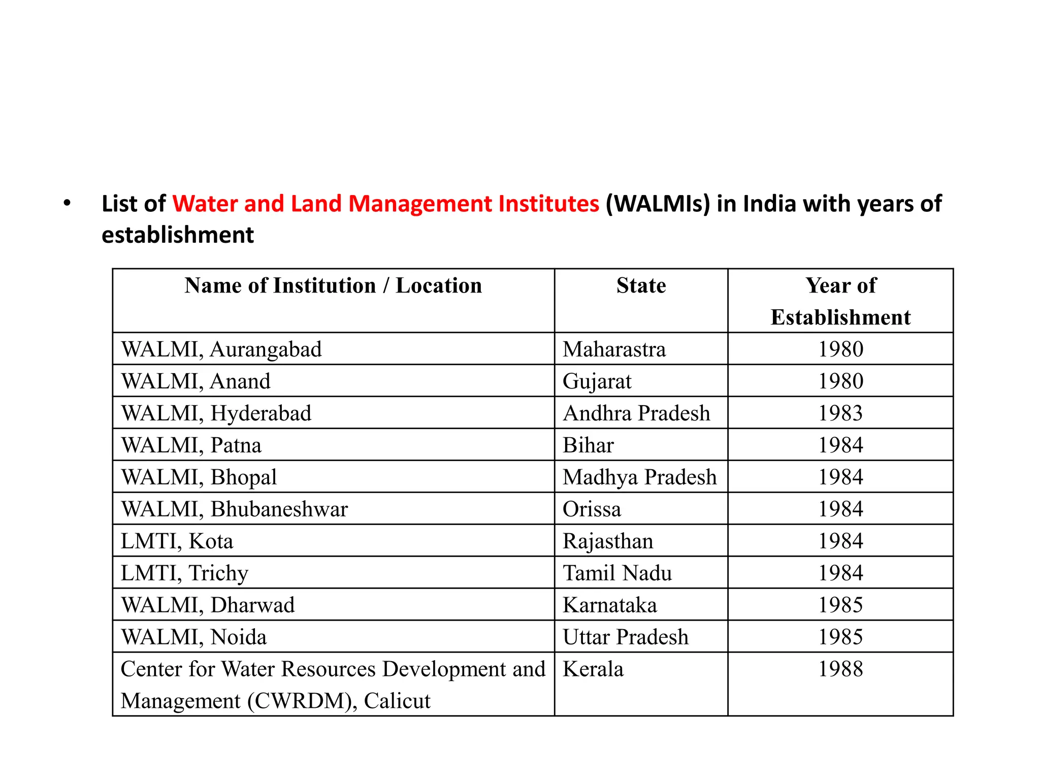
SWE 303 IRRIGATION AND
DRAINAGE ENGINEERING
Lecture – 1 Water Resources – River basins – Development
and utilization in India and Tamil Nadu
Global water scenario
• The oceans occupy about 70.8% of the earth’s surface and only 29.2% is land.
About 97.3% of the world water resource is in the oceans and is saline. Of the
remaining 2.7% of the global fresh water resource, about 75.2% is in ice caps and
glaciers and is not available for the requirements of mankind.
• Groundwater is the 2nd largest available reservoir of fresh water. The diagram below shows
that of the world's fresh water, the majority is locked away as ice in the polar ice caps,
continental ice sheets and glaciers. Surface waters such as rivers and lakes only accounts for
less that 1% of the worlds fresh water reserves whereas groundwater accounts for 12% of
the worlds freshwater resources.
Water supply & Demand
Water budget in India
• India geographical area is 329 M.ha.
• India average annual rainfall is about 1170 mm
• The amount of rainfall over the area of 329 million ha amounts to around 390
million ha-metres.
• One third of India is drought prone, while one-eighth is flood prone.
There are 130 rainy days in a year in the country and on 75 days the rainfall is
below 2.5 mm.
• India’s average annual surface run-off generated by rainfall and snowmelt is
estimated to be about 1869 billion cubic meter (BCM).
Water resources of India
I) Rainfall
• Source of all water is precipitation. A number of factors such as ocean currents,
trade winds, air-mass movement, orographic effects and the location of the place
with respect to physical barrier, all affect the amount of rainfall at a given location.
As a result, the rainfall in the country is highly variable, irregular and
undependable with widespread variations among various meteorological sub-
division in terms of distribution and amounts
Rainfall
Average Annual Rainfall - 1170 mm
Maximum Average Annual Rainfall - 11000 mm
(Cherrapunji)
Minimum Average Annual Rainfall -100 mm
(Western Rajasthan)
Water Availability
(In Billion cubic metre)
Total Precipitation : 4000
Total Water Availability : 1869
Total Utilisable Water : 1122
 Surface Water - 690
 Ground Water - 432
• Khasi-Jaintia hills in the extreme east (Meghalaya) is one of the rainiest areas in
the world with an annual average of the order of 10000-10500 mm. In the
extreme west in Rajasthan, there are areas receiving less than 100 mm. Almost
the entire country east of longitude 79oE and the west coast has normal annual
rainfall of more than 1000 mm. Most of the west coast gets more than 2500 mm.
Rainfall in the Peninsular India excluding coastal belts is generally in the range of
500-750 mm. In the north-west India, it decreases to less than 300 mm west of
Jodhpur.
• India is blessed with an average annual rainfall of about 1194-mm. However, the
bounty is not evenly spread both in time and space with the result flood-drought-
flood syndrome still persists. As much as 85-90% of the rainfall is received only in
the southwest monsoon season of June to October. It is that during the four rainy
months of June to September the Arabian Sea branch of the monsoon carries
moisture amounting to about 770 million ha meters and the Bay of Bengal branch
about 340 million ha meters of water.
• Of the monsoon moisture, about 25 – 30% precipitates in the form of rainfall.
During the remaining eight months an approximate precipitation of 100 million ha
meters including a small portion of snow pour over the country. There are on
average 130 rainy days in a year in the country.
Water Resources of India
II) Soil moisture and ground water recharge:
• Out of the annual rainfall of 400 million ha-m about 215 million ha-m infiltrates
into the soil. A major part of it, amounting to about 165 million ha, is retained as
soil moisture which is essential for the growth of vegetation. Various soil
conservation and water harvesting measures are increasing the ground water
recharge.
• The total surface water resources of India after considering the above have been
assessed at 180 million ha meters. This 180 million ha meters includes about 20
million ha meters brought in by streams and rivers from catchments lying outside
the country and about 45 million ha meters pertains to regenerated flow from
groundwater as assessed from river flows during non-rainy months. The remaining
115 million ha meters constitutes direct contribution by precipitation, of
• which about 10 million ha meters is received as snowfall. Of the 180 million ha
meters, due to limitations imposed by topography, climate, soil conditions etc.,
only about 69 million ha meters are considered utilizable. The present utilization of
the surface water is estimated to be about 31.12 million ha meters, of which about
95% is used for irrigation with the remaining being put to other uses.
Major River basin of India
Rivers
The biggest major rivers of India are:
• Flowing into the Bay of Bengal: Brahmaputra, Ganges (with its main tributaries
Ramganga, Kali or Sharda, Gomti, Yamuna, Chambal, Betwa, Ken, Sindh, Tons,
Ghaghara, Gandaki, Burhi Gandak, Koshi, Mahananda, Tamsa, Son, Punpun),
Meghna, Mahanadi, Godavari, Krishna, Kaveri (and their main tributaries)
• Flowing into the Arabian Sea: Indus, Narmada, Tapi (and their main tributaries)
The remaining rivers are as follows:
• Flowing into the Inner part of Coastal rivers.
Sl.
No.
Name of the River Basin Average annual availability
1. Indus (up to Border) 73.31
2. a) Ganga 525.02
b) Brahmaputra ,Barak & Others 585.60
3. Godavari 110.54
4. Krishna 78.12
5. Cauvery 21.36
6. Pennar 6.32
7. East Flowing Rivers Between Mahanadi & Pennar 22.52
8. East Flowing Rivers Between Pennar and Kanyakumari 16.46
9. Mahanadi 66.88
10. Brahmani & Baitarni 28.48
11. Subernarekha 12.37
12. Sabarmati 3.81
13. Mahi 11.02
14. West Flowing Rivers of Kutch, Sabarmati including Luni 15.10
15. Narmada 45.64
16. Tapi 14.88
17. West Flowing Rivers from Tapi to Tadri 87.41
18. West Flowing Rivers from Tadri to Kanyakumari 113.53
19. Area of Inland drainage in Rajasthan desert Neg.
20. Minor River Basins Draining into Bangladesh & Burma 31.00
Total 1869.35
Table:1 Water availability – basin wise
Cubic Km/Year
III) Ground water:
• Ground water occurs in the zone of saturation below the land surface. Ground
water is in a dynamic state and moves slowly. The quantum of the water which can
be extracted economically every year is considered as the groundwater potential.
India’s rechargeable annual groundwater potential has been assessed at around
431 BCM in aggregate terms. On an all India basis it is estimated that about 30 per
cent of the groundwater potential has been tapped for irrigation and domestic
use.
Irrigation Development
In 1951
16%
In 2002
67%
Potential Created as % of Ultimate Irrigation Potential
Irrigation Sources
39%
13%
48%
Major & Medium Irrigation
Minor (Surface Water)
Minor(Ground Water)
Demands of Various Sectors
0
200
400
600
800
1000
1200
1400
1997 2010 2025 2050
Demand(Billion
cubic
metre)
Evaporation Losses
Environment
(Ecology)
Inland Navigation
Power
Industries
Domestic
Irrigation
Irrigation development in India
• Medieval India
• There is evidence that irrigation was practiced in India during Vedic periods. The
concepts of storing river flows behind a dam, distribution of stored water through
canals so as to ensure equity among farmers and adequate irrigation to the crops
were well known and practiced even before 3000 B.C.
• Further, the remains of Indus Valley Civilization that flourished up to 1750 B.C also
revealed the existence of the farm communities in the Indian sub-continent. The
Grand Anicut across the river Cauvery in Tamilnadu was constructed by Chola kings
as early as in the 2nd Century A.D., and was providing irrigation to about 0.24
million hectares, when its renovation was taken up by the British. Likewise the
Viranarayana and Gangaikonda- Cholapuram tanks in Tamilnadu and
Anantarajasagara in Andhra Pradesh were constructed during 10th and 13th
Century, respectively. Ghiyasuddin Tughluq (1220 – 1250) is credited to be the first
ruler who encouraged digging canals. Subsequently in the 14th Century during the
reign of Feroz Shah Tughlaq and Shahjahan the development of canal irrigation was
given impetus and the western and Eastern Jamuna Canal in Haryana was laid out.
Maste Canal followed these on the river Ravi during the 18th Century. It was also
noticed that the Chandel Kings in Bundelkhand region constructed large number of
tanks that continued to be used till the 18th Century.
• British period
• Irrigation development under British rule began with the renovation, improvement and
extension of the then existing works. Later the period from 1836 – 1866 marked the
investigation, development and completion of four major river-diversion works of
considerable size viz., Upper Ganga Canal, Upper Bari Doab Canal, Krishna & Godavari
Delta systems. In 1867, the British Government adopted the practice of taking up
works, which promised a minimum net return. Thereafter, a number of projects were
taken up.
• These included major canal works like the Sirhind, the Lower Ganga, the Agra and the
Mutha Canals, and the Periyar Dam and canals. Some other major canal projects were
also completed on the Indus river during this period. These included the Lower Swat,
the Lower Sohag and Para, the Lower Chenab and the Sidhnai Canals, all of which went
to Pakistan in 1947. However, as a result of the famine during 1876 – 1878, the country
received serious setback in agricultural production. Consequently, the First Famine
Commission was setup by the Government in 1880, which recommended for irrigation
development in drought prone areas. Significant protective works constructed during
the period were the Betwa Canal, the Nira Left Bank Canal, the Gokak Canal, the
Khaswad Tank and the Rushikulya Canal. The good harvest during the next 15 years led
to complacency and no comprehensive plan for irrigation was prepared.
• British period ………….
• The last two years of the 19th Century (1899 – 1900) again witnessed devastating famines. This led
to the appointment of First Irrigation Commission in the year 1901 to ascertain the usefulness of
irrigation against famines. Big spurt in irrigation development was thus, observed in the first
quarter of 20th Century. The total irrigated area through public works in 1920-21 rose to 19.3
million hectares over a base of 13.3 million ha in 1900. About 8.9 million ha more area was brought
under irrigation up till 1946-47. Thus, before partition the total irrigated area was 28.2 million ha
inclusive of Princely State’s private irrigation (4.7 million ha). At the time of partition in 1947, about
8.8 million ha irrigated area went to Pakistan and 19.4 million ha remained with India. To cope up
with the demand of food grains for growing population, a good number of Multipurpose River
Valley Projects viz., Bhakra Nangal, Damodar Valley and Hirakud dams were initiated soon after
independence. At the beginning of First Five Year Plan in 1950-51 the irrigated area was 22.6 million
ha (9.7 million ha under major and medium irrigation projects and 12.9 million ha under minor
irrigation schemes from both surface and groundwater sources).
• The post independence era through Five-Year Plans witnessed planned efforts in irrigation
development in the country. The Rajasthan Canal, Gandhisagar Dam, Gandak, Kosi, Nagarjunasagar,
Tungabhadra, Malprabha, Ghataprabha and Farakka irrigation projects were taken up during the
first two Five Year Plans (1950-51 to 1960-61). Subsequently projects such as Tawa, Ramganga,
SriRamsagar, Ukai, Kadana, Teesta, Tehri, Jayakwadi, Beas, Gandak, Sardar Sarovar, Chambal, Mahi,
Mahanadi delta, Idukki, Koyna, Narmada Sagar Valley etc., were initiated
Irrigation projects:
• Irrigation projects were classified on the basis of culturable command area of the
project. Irrigation projects are classified into the following three categories:
• Major irrigation projects : All irrigation schemes with a culturable command are of
10000 ha or more are classified as major irrigation projects. They are surface water
projects involving large scale storage/diversion works.
• Medium irrigation projects: Projects having a culturable command area of 2000 ha
to 10000 ha are classified as medium irrigation projects. Medium irrigation
projects are also usually surface water projects excepting a few large lift irrigation
schemes.
• Minor irrigation projects: All irrigation schemes having a culturable command area
up to 2000 ha individually are classified as minor irrigation projects. Minor
irrigation schemes are further grouped as (a) surface water minor irrigation
schemes and (b) ground water minor irrigation schemes.
Table1. Important major irrigation projects in India
• With an average irrigation intensity of 140%, the actual net irrigated area is likely
to be around 62.31 million ha, which is only 43% of the net sown area of the
country (142 million ha).
Major Irrigation Projects in India
1. Nagarjunasagar (Andhra Pradesh): on the Krishna river near Nandikona village (about 44 km from Hyderabad.).
2. Tungabhadra (Joint project of Andhra Pradesh and Karnatka): On the Tungabhadra river.
3. Gandak (joint project of Bihar and Uttar Pradesh): Nepal also derives irrigation and power benefits from this project.
4. Kosi(Bihar): A multipurpose project , which serves bihar and Nepal.
5. Sone high level canal (Bihar) : an extention on sone barrage project.
6. Kakrapara (Gujarat) : on the Tapti river near Kakrapara , in surat district.
7. Ukal (Gujarat): A multiupurpose project, across Tapti river near Ukai village.
8. Mahi (Gujarat ): A two – phase project , one across the Mahi river near Wanakbori village and the other across Mahi river near Kadana.
9. Sabarmati (Gujarat): A storage dam across Sabarmati river near Dhari village in Mehsana district and Wasna barrage near Ahmedabad.
10. Panam (Gujarat): A masonry dam across Panam river near Keldezar village in Panchmahals district.
11. Karjan(Gujarat):A masonry dam across Karjan river near Jiotgarh village in Nandoo Taluka of Bharuch district.
12. Bhadra (Karnataka ):A multipurpose project across the river Bhadra .
13. Upper Krishna (Karnataka) : A project consisting of Narayanpur dam across the Krishna river and a dam at Almatti.
14. Ghataprabha (Karnataka): A project across Ghataprabha in Belgaum and Bijapur districts.
15. Malaprabha (Karnataka) : A dam across ithe Malaprabha in Belguam district.
Tawa (Madhya Pradesh ): A project the Tawa river , a tributary of the Narmada in Hoshangabad district.
16. Chambal (joint project of Madhya Pradesh and rajasthan): The project comprises Gandhi Sagar dam , Rana Sagar dam and Jawahar Sagar dam.
17. Mahanadi Reservoir Project (Madhya pradesh): It has three phases : (1) Ravishankar sagar project and feeder canal system for supply of water
to Bhilai Steel plant and Sandur dam across Sandur village, (2) extension of Mahanadi feeder canal (3) Pairi dam.
18. Hasdeo Bango Project(Madhya Pradesh ): It the third phase of Hasdeo Bango Project complex and envisages construction of a masonry dam
across Hasdeo river. The first and second phases have been substantially completed .
19. Bargi Project (Madhya pradesh): It is a multipurpose project consisting of a masonry dam across Bargi river in the Jabalpur district and a left
bank a canal.
20. Bhima (Maharashtra) : Comprises two dams , one on the Pawana river near Phange in Pune district and the other across the Krishna river near
Ujjaini in Sholapur district.
21. Jayakwadi(Maharashtra) : A masonry spillway across the river Godavari .
22. Kukadi Project (Maharashtra) : Five independent storage dams ,i.e., Yodgaon, Manikdohi, Dimba, Wadaj and Pimpalgaon jog . The canal system
comprises (1) Kukadi left bank canal, (2) Dhimba left bank canal, (3) Dhimba right bank canal (4)Meena feeder and (5) Meena branch .
23. Krishna Project (Maharashtra ): Dhom dam near Dhom village on Krishna and Kanhar village on Varna river in Satna district.
24. Upper Penganga (Mahrarhtra ) : Two reservoirs on Penganga river at Isapur in Yavatmal district and the other on Rayadhu river at Sapli in
Parbhani district.
25. Hirakud(Orrisa): World’s longest dam, is located on the Mahanadi river.
26. Mahandi Delta Scheme (Orissa): The irrigation scheme will utilize releases from the Hirakud reservoir.
27. Bhakra Nangal (Joint project of Haryana, Punjab and Rajasthan): India’s biggest multipurpose river valley project comprises a straight gravity
dam across the Satlej at Bhakra, the Nangal dam, the Nangal hydal channel, two power houses at Bhakra dam at and two power station at
Ganguwal and Kotla.
28. Beas (Joint venture of Haryana , Punjab , and Rajasthan) : It consists of Beas-Sutlej link and Beas dam at Pong.
Main organizations dealing with water resources in India
(I) Central government organizations
Ministries involved in water sector
1. Ministry of water resources (MOWR)
2. Ministry of Agriculture (MOA)
3. Ministry of Power
4. Ministry of Environment & Forests
5. Ministry of surface transport
(II) State Government Organization
1) Central Water and Power Research Station
2) National Water Development Agency (NWDA)
3) Water and Power Consultancy Services (India) Limited
4) Narmada Control Authority
5) Indian Council of Agriculture Research (ICAR)
6) National Water Board
7) Bureau of Indian Standards (BIS)
(III) River basin organizations
1) Damodar Valley Corporation
2) Sardar Sarovar Construction Advisory Committee (SSCAC)
3) Farakka Barrage Project, Farakka
4) Upper Yamuna River Board (UYRB)
5) Tungabhadra Board
• List of Water and Land Management Institutes (WALMIs) in India with years of
establishment
Name of Institution / Location State Year of
Establishment
WALMI, Aurangabad Maharastra 1980
WALMI, Anand Gujarat 1980
WALMI, Hyderabad Andhra Pradesh 1983
WALMI, Patna Bihar 1984
WALMI, Bhopal Madhya Pradesh 1984
WALMI, Bhubaneshwar Orissa 1984
LMTI, Kota Rajasthan 1984
LMTI, Trichy Tamil Nadu 1984
WALMI, Dharwad Karnataka 1985
WALMI, Noida Uttar Pradesh 1985
Center for Water Resources Development and
Management (CWRDM), Calicut
Kerala 1988
Lecture – 2 Irrigation – advantage - disadvantage
• What is Agricultural Irrigation?
– Irrigation has been practiced for more than 6000 years on this planet and was critical to the
development of some early civilization, as well as to the sustainability and progress of modern
civilization
– Many parts of Asia also have evidence of over one thousand years of agricultural irrigation
– Remains of a 6,000-year-old rice paddy with vestiges of irrigation channels connecting it to a
well have been discovered in China
– The first irrigation was by gravity diversion and from water lifters powered by humans, animals
or by the flow of water
– Modern irrigation practices include a variety of surface irrigation methods, sprinkle, mist, and
drip or trickle systems
– The term "irrigation" is sometimes used with reference to both water supply to crops and
drainage
– In some agricultural areas in the tropics the rainfall is usually more than adequate to meet
crop water requirements, and drainage systems are more important than irrigation systems in
these areas
– The term "irrigation system" may refer to an on-farm system, or to an entire project
– There are various definitions for irrigation, each depending on the perspective or discipline
from which it is derived.
Irrigation – Definition:
• It is generally defined as “application of water to soil for the purpose of supplying
the moisture essential for normal plant growth and development”. In other words
it is the human manipulation of hydrological cycle to improve crop production and
quality and to decrease the economic effects of drought. However, a broader and
more meaningful definition is that irrigation is the application of water to the soil
for the following purposes:
• To add water to the soil for supplying moisture essential for normal plant growth
and development
• To provide crop insurance against short duration droughts
• To leach or dilute excessive salts in the crop root zone, thereby providing a
favourable environment in the soil profile for absorption of water and nutrients
• To soften tillage pans
• To cool the soil and atmosphere, thereby making more favourable
microenvironment for plant growth
Objectives of irrigation
The broad objectives of irrigation are as follows:
a) To increase crop production on sustainable basis where water is a limitation
• To increase national income/national cash-flow
• To increase labour employment
• To increase standard of living
b) Modification of soil & climatic environment
• For leaching of salts
• For reclamation of sodic soils
• For frost protection
c) To mitigate i.e., lessen the risk of catastrophes caused by drought
• To overcome food shortages
• To protect high value crops/trees
d) To increase population of arid and sparsely populated areas
• For national defense
• For population re-distribution
e) National security i.e., self sufficiency in food grain production
Advantage of irrigation:
• The main advantage of irrigation is it supplies water to the crops, removing the uncertainty over
rainfall amount and timing.
• Irrigation is particularly important in dry areas where water is scarce or it does not rain in periods
when the crop needs water the most. Irrigation also meets the crop water demand. Typically, a crop
needs about 2-5 mm of water per day, but on hot days, the crop water demand can reach even up to
10 mm a day. So, with irrigation, the additional crop water demand can be met.
• Irrigation also allows crops to be planted indoors such as in green- or glasshouses. Moreover,
irrigation allows farmers to supply water and nutrients simultaneously to their crops. This process is
called fertigation, where nutrients (fertilizers) are added into the water which is then supplied to the
crop. Fertigation is mostly carried out with drip irrigation system where water is supplied directly into
the roots to save both water and nutrients.
Some of the advantages of irrigation are as follows.
• Increase of food production.
• Modify soil or climate environment – leaching.
• Lessen risk of catastrophic damage caused by drought.
• Increase income & national cash flow.
• Increase labor employment.
• Increase standard of living.
• Increase value of land.
• National security thus self sufficiency.
• Improve communication and navigation facilities.
• Domestic and industrial water supply.
• Improve ground water storage.
• Generation of hydro-electric power.
Disadvantages of Irrigation
The following are the disadvantages of irrigation.
• Water logging.
• Salinity and alkalinity of land.
• Ill aeration of soil.
• Pollution of underground water.
• Results in colder and damper climate causing outbreak of diseases like malaria.
Lecture – 3 Duty of water – expression – relationship between duty and
delta, Rooting characteristics and moisture use of crop
Duty of water
It is the relationship between the irrigation water and the area of the crop that
matures fully with the given amount of water. Duty is expressed as follows:
1. Area per unit rate of flow (ha/cumec)
2. Depth of water or Delta (ha/depth of water)
3. In terms of stored water (ha/million m3 of stored water)
Base period
The time between first irrigation to a crop at sowing or planting and last irrigation
before harvest on a given field.
Relationship between duty, delta and base period
• Let there be a crop of base period ‘B’ period
• Let 1 cumec of water be applied to this crop on the field for ‘B’ days
• The total quantity of water applied in ‘B’ days = 1 x B x 24 x 60 x 60 m3.
• Let this be equal to V = 1 x B x 24 x 60 x 60 m3
• Let V m3 of water bring to maturity ‘D’ ha of land A = D x 10000 m2
FACTORS AFFECTING DUTY:
The factors that affect the duty are described below,
1. Soil Characteristics:
If the soil of the canal bed is porous and coarse grained, it leads to more seepage loss and consequently
low duty. If it consists of alluvial soil, the percolation loss will be less and the soil retains the moisture
for longer period and consequently the duty will be high.
2. Climatic Condition:
When the temperature of the command area is high the evaporation loss is more and the duty becomes
low and vice versa.
3. Rainfall:
If rainfall is sufficient during the crop period, the duty will be more and vice versa.
4. Base Period:
When the base period is longer, the water requirement will be more and the duty will be low and vice
versa.
5. Type of Crop:
The water requirement for various crops is different. So the duty varies from crop to crop.
6. Topography of Agricultural Land:
If the land is uneven the duty will be low. As the ground slope increases the duty decreases because there
is wastage of water.
7. Method of Ploughing:
Proper deep ploughing which is done by tractors requires overall less quantity of water and hence the duty
is high.
8. Methods of Irrigation:
The duty of water is high in case of perennial irrigation system as compared to that in inundation irrigation
system.
9. Water Tax:
If some tax is imposed the farmer will use the water economically thus increasing the duty.
METHODS OF IMPROVING DUTY:
Various methods of improving duty are:
(1) Proper Ploughing:
Ploughing should be done properly and deeply so that the moisture retaining capacity of soil is increased.
(2) Methods of supplying water:
The method of supplying water to the agriculture land should be decided according to the field and soil
conditions. For example,
Furrow method For crops sown ion rows
Contour method For hilly areas
Basin For orchards
Flooding For plain lands
(3) Canal Lining:
It is provided to reduce percolation loss and evaporation loss due to high velocity.
(4) Minimum idle length of irrigation Canals:
The canal should be nearest to the command area so that idle length of the canal is minimum and hence
reduced transmission losses.
(5) Quality of water:
Good quality of water should be used for irrigation. Pollution en route the canal should be avoided.
(6) Crop rotation:
The principle of crop rotation should be adopted to increase the moisture retaining capacity and fertility of
the soil.
(7) Method of Assessment of water:
Particularly, the volumetric assessment would encourage the farmer to use the water carefully.
(8) Implementation of Tax:
The water tax should be imposed on the basis of volume of water consumption
Water resources study ppt for references

Water resources study ppt for references

  • 1.
    SWE 303 IRRIGATIONAND DRAINAGE ENGINEERING
  • 2.
    Lecture – 1Water Resources – River basins – Development and utilization in India and Tamil Nadu
  • 3.
    Global water scenario •The oceans occupy about 70.8% of the earth’s surface and only 29.2% is land. About 97.3% of the world water resource is in the oceans and is saline. Of the remaining 2.7% of the global fresh water resource, about 75.2% is in ice caps and glaciers and is not available for the requirements of mankind.
  • 5.
    • Groundwater isthe 2nd largest available reservoir of fresh water. The diagram below shows that of the world's fresh water, the majority is locked away as ice in the polar ice caps, continental ice sheets and glaciers. Surface waters such as rivers and lakes only accounts for less that 1% of the worlds fresh water reserves whereas groundwater accounts for 12% of the worlds freshwater resources.
  • 6.
  • 7.
    Water budget inIndia • India geographical area is 329 M.ha. • India average annual rainfall is about 1170 mm • The amount of rainfall over the area of 329 million ha amounts to around 390 million ha-metres. • One third of India is drought prone, while one-eighth is flood prone. There are 130 rainy days in a year in the country and on 75 days the rainfall is below 2.5 mm. • India’s average annual surface run-off generated by rainfall and snowmelt is estimated to be about 1869 billion cubic meter (BCM).
  • 8.
    Water resources ofIndia I) Rainfall • Source of all water is precipitation. A number of factors such as ocean currents, trade winds, air-mass movement, orographic effects and the location of the place with respect to physical barrier, all affect the amount of rainfall at a given location. As a result, the rainfall in the country is highly variable, irregular and undependable with widespread variations among various meteorological sub- division in terms of distribution and amounts
  • 9.
    Rainfall Average Annual Rainfall- 1170 mm Maximum Average Annual Rainfall - 11000 mm (Cherrapunji) Minimum Average Annual Rainfall -100 mm (Western Rajasthan)
  • 10.
    Water Availability (In Billioncubic metre) Total Precipitation : 4000 Total Water Availability : 1869 Total Utilisable Water : 1122  Surface Water - 690  Ground Water - 432
  • 11.
    • Khasi-Jaintia hillsin the extreme east (Meghalaya) is one of the rainiest areas in the world with an annual average of the order of 10000-10500 mm. In the extreme west in Rajasthan, there are areas receiving less than 100 mm. Almost the entire country east of longitude 79oE and the west coast has normal annual rainfall of more than 1000 mm. Most of the west coast gets more than 2500 mm. Rainfall in the Peninsular India excluding coastal belts is generally in the range of 500-750 mm. In the north-west India, it decreases to less than 300 mm west of Jodhpur.
  • 12.
    • India isblessed with an average annual rainfall of about 1194-mm. However, the bounty is not evenly spread both in time and space with the result flood-drought- flood syndrome still persists. As much as 85-90% of the rainfall is received only in the southwest monsoon season of June to October. It is that during the four rainy months of June to September the Arabian Sea branch of the monsoon carries moisture amounting to about 770 million ha meters and the Bay of Bengal branch about 340 million ha meters of water. • Of the monsoon moisture, about 25 – 30% precipitates in the form of rainfall. During the remaining eight months an approximate precipitation of 100 million ha meters including a small portion of snow pour over the country. There are on average 130 rainy days in a year in the country.
  • 13.
  • 14.
    II) Soil moistureand ground water recharge: • Out of the annual rainfall of 400 million ha-m about 215 million ha-m infiltrates into the soil. A major part of it, amounting to about 165 million ha, is retained as soil moisture which is essential for the growth of vegetation. Various soil conservation and water harvesting measures are increasing the ground water recharge. • The total surface water resources of India after considering the above have been assessed at 180 million ha meters. This 180 million ha meters includes about 20 million ha meters brought in by streams and rivers from catchments lying outside the country and about 45 million ha meters pertains to regenerated flow from groundwater as assessed from river flows during non-rainy months. The remaining 115 million ha meters constitutes direct contribution by precipitation, of • which about 10 million ha meters is received as snowfall. Of the 180 million ha meters, due to limitations imposed by topography, climate, soil conditions etc., only about 69 million ha meters are considered utilizable. The present utilization of the surface water is estimated to be about 31.12 million ha meters, of which about 95% is used for irrigation with the remaining being put to other uses.
  • 15.
  • 16.
    Rivers The biggest majorrivers of India are: • Flowing into the Bay of Bengal: Brahmaputra, Ganges (with its main tributaries Ramganga, Kali or Sharda, Gomti, Yamuna, Chambal, Betwa, Ken, Sindh, Tons, Ghaghara, Gandaki, Burhi Gandak, Koshi, Mahananda, Tamsa, Son, Punpun), Meghna, Mahanadi, Godavari, Krishna, Kaveri (and their main tributaries) • Flowing into the Arabian Sea: Indus, Narmada, Tapi (and their main tributaries) The remaining rivers are as follows: • Flowing into the Inner part of Coastal rivers.
  • 17.
    Sl. No. Name of theRiver Basin Average annual availability 1. Indus (up to Border) 73.31 2. a) Ganga 525.02 b) Brahmaputra ,Barak & Others 585.60 3. Godavari 110.54 4. Krishna 78.12 5. Cauvery 21.36 6. Pennar 6.32 7. East Flowing Rivers Between Mahanadi & Pennar 22.52 8. East Flowing Rivers Between Pennar and Kanyakumari 16.46 9. Mahanadi 66.88 10. Brahmani & Baitarni 28.48 11. Subernarekha 12.37 12. Sabarmati 3.81 13. Mahi 11.02 14. West Flowing Rivers of Kutch, Sabarmati including Luni 15.10 15. Narmada 45.64 16. Tapi 14.88 17. West Flowing Rivers from Tapi to Tadri 87.41 18. West Flowing Rivers from Tadri to Kanyakumari 113.53 19. Area of Inland drainage in Rajasthan desert Neg. 20. Minor River Basins Draining into Bangladesh & Burma 31.00 Total 1869.35 Table:1 Water availability – basin wise Cubic Km/Year
  • 18.
    III) Ground water: •Ground water occurs in the zone of saturation below the land surface. Ground water is in a dynamic state and moves slowly. The quantum of the water which can be extracted economically every year is considered as the groundwater potential. India’s rechargeable annual groundwater potential has been assessed at around 431 BCM in aggregate terms. On an all India basis it is estimated that about 30 per cent of the groundwater potential has been tapped for irrigation and domestic use.
  • 19.
    Irrigation Development In 1951 16% In2002 67% Potential Created as % of Ultimate Irrigation Potential
  • 20.
    Irrigation Sources 39% 13% 48% Major &Medium Irrigation Minor (Surface Water) Minor(Ground Water)
  • 21.
    Demands of VariousSectors 0 200 400 600 800 1000 1200 1400 1997 2010 2025 2050 Demand(Billion cubic metre) Evaporation Losses Environment (Ecology) Inland Navigation Power Industries Domestic Irrigation
  • 22.
    Irrigation development inIndia • Medieval India • There is evidence that irrigation was practiced in India during Vedic periods. The concepts of storing river flows behind a dam, distribution of stored water through canals so as to ensure equity among farmers and adequate irrigation to the crops were well known and practiced even before 3000 B.C. • Further, the remains of Indus Valley Civilization that flourished up to 1750 B.C also revealed the existence of the farm communities in the Indian sub-continent. The Grand Anicut across the river Cauvery in Tamilnadu was constructed by Chola kings as early as in the 2nd Century A.D., and was providing irrigation to about 0.24 million hectares, when its renovation was taken up by the British. Likewise the Viranarayana and Gangaikonda- Cholapuram tanks in Tamilnadu and Anantarajasagara in Andhra Pradesh were constructed during 10th and 13th Century, respectively. Ghiyasuddin Tughluq (1220 – 1250) is credited to be the first ruler who encouraged digging canals. Subsequently in the 14th Century during the reign of Feroz Shah Tughlaq and Shahjahan the development of canal irrigation was given impetus and the western and Eastern Jamuna Canal in Haryana was laid out. Maste Canal followed these on the river Ravi during the 18th Century. It was also noticed that the Chandel Kings in Bundelkhand region constructed large number of tanks that continued to be used till the 18th Century.
  • 23.
    • British period •Irrigation development under British rule began with the renovation, improvement and extension of the then existing works. Later the period from 1836 – 1866 marked the investigation, development and completion of four major river-diversion works of considerable size viz., Upper Ganga Canal, Upper Bari Doab Canal, Krishna & Godavari Delta systems. In 1867, the British Government adopted the practice of taking up works, which promised a minimum net return. Thereafter, a number of projects were taken up. • These included major canal works like the Sirhind, the Lower Ganga, the Agra and the Mutha Canals, and the Periyar Dam and canals. Some other major canal projects were also completed on the Indus river during this period. These included the Lower Swat, the Lower Sohag and Para, the Lower Chenab and the Sidhnai Canals, all of which went to Pakistan in 1947. However, as a result of the famine during 1876 – 1878, the country received serious setback in agricultural production. Consequently, the First Famine Commission was setup by the Government in 1880, which recommended for irrigation development in drought prone areas. Significant protective works constructed during the period were the Betwa Canal, the Nira Left Bank Canal, the Gokak Canal, the Khaswad Tank and the Rushikulya Canal. The good harvest during the next 15 years led to complacency and no comprehensive plan for irrigation was prepared.
  • 24.
    • British period…………. • The last two years of the 19th Century (1899 – 1900) again witnessed devastating famines. This led to the appointment of First Irrigation Commission in the year 1901 to ascertain the usefulness of irrigation against famines. Big spurt in irrigation development was thus, observed in the first quarter of 20th Century. The total irrigated area through public works in 1920-21 rose to 19.3 million hectares over a base of 13.3 million ha in 1900. About 8.9 million ha more area was brought under irrigation up till 1946-47. Thus, before partition the total irrigated area was 28.2 million ha inclusive of Princely State’s private irrigation (4.7 million ha). At the time of partition in 1947, about 8.8 million ha irrigated area went to Pakistan and 19.4 million ha remained with India. To cope up with the demand of food grains for growing population, a good number of Multipurpose River Valley Projects viz., Bhakra Nangal, Damodar Valley and Hirakud dams were initiated soon after independence. At the beginning of First Five Year Plan in 1950-51 the irrigated area was 22.6 million ha (9.7 million ha under major and medium irrigation projects and 12.9 million ha under minor irrigation schemes from both surface and groundwater sources). • The post independence era through Five-Year Plans witnessed planned efforts in irrigation development in the country. The Rajasthan Canal, Gandhisagar Dam, Gandak, Kosi, Nagarjunasagar, Tungabhadra, Malprabha, Ghataprabha and Farakka irrigation projects were taken up during the first two Five Year Plans (1950-51 to 1960-61). Subsequently projects such as Tawa, Ramganga, SriRamsagar, Ukai, Kadana, Teesta, Tehri, Jayakwadi, Beas, Gandak, Sardar Sarovar, Chambal, Mahi, Mahanadi delta, Idukki, Koyna, Narmada Sagar Valley etc., were initiated
  • 25.
    Irrigation projects: • Irrigationprojects were classified on the basis of culturable command area of the project. Irrigation projects are classified into the following three categories: • Major irrigation projects : All irrigation schemes with a culturable command are of 10000 ha or more are classified as major irrigation projects. They are surface water projects involving large scale storage/diversion works. • Medium irrigation projects: Projects having a culturable command area of 2000 ha to 10000 ha are classified as medium irrigation projects. Medium irrigation projects are also usually surface water projects excepting a few large lift irrigation schemes. • Minor irrigation projects: All irrigation schemes having a culturable command area up to 2000 ha individually are classified as minor irrigation projects. Minor irrigation schemes are further grouped as (a) surface water minor irrigation schemes and (b) ground water minor irrigation schemes.
  • 26.
    Table1. Important majorirrigation projects in India
  • 27.
    • With anaverage irrigation intensity of 140%, the actual net irrigated area is likely to be around 62.31 million ha, which is only 43% of the net sown area of the country (142 million ha).
  • 28.
    Major Irrigation Projectsin India 1. Nagarjunasagar (Andhra Pradesh): on the Krishna river near Nandikona village (about 44 km from Hyderabad.). 2. Tungabhadra (Joint project of Andhra Pradesh and Karnatka): On the Tungabhadra river. 3. Gandak (joint project of Bihar and Uttar Pradesh): Nepal also derives irrigation and power benefits from this project. 4. Kosi(Bihar): A multipurpose project , which serves bihar and Nepal. 5. Sone high level canal (Bihar) : an extention on sone barrage project. 6. Kakrapara (Gujarat) : on the Tapti river near Kakrapara , in surat district. 7. Ukal (Gujarat): A multiupurpose project, across Tapti river near Ukai village. 8. Mahi (Gujarat ): A two – phase project , one across the Mahi river near Wanakbori village and the other across Mahi river near Kadana. 9. Sabarmati (Gujarat): A storage dam across Sabarmati river near Dhari village in Mehsana district and Wasna barrage near Ahmedabad. 10. Panam (Gujarat): A masonry dam across Panam river near Keldezar village in Panchmahals district. 11. Karjan(Gujarat):A masonry dam across Karjan river near Jiotgarh village in Nandoo Taluka of Bharuch district. 12. Bhadra (Karnataka ):A multipurpose project across the river Bhadra . 13. Upper Krishna (Karnataka) : A project consisting of Narayanpur dam across the Krishna river and a dam at Almatti. 14. Ghataprabha (Karnataka): A project across Ghataprabha in Belgaum and Bijapur districts. 15. Malaprabha (Karnataka) : A dam across ithe Malaprabha in Belguam district. Tawa (Madhya Pradesh ): A project the Tawa river , a tributary of the Narmada in Hoshangabad district. 16. Chambal (joint project of Madhya Pradesh and rajasthan): The project comprises Gandhi Sagar dam , Rana Sagar dam and Jawahar Sagar dam. 17. Mahanadi Reservoir Project (Madhya pradesh): It has three phases : (1) Ravishankar sagar project and feeder canal system for supply of water to Bhilai Steel plant and Sandur dam across Sandur village, (2) extension of Mahanadi feeder canal (3) Pairi dam. 18. Hasdeo Bango Project(Madhya Pradesh ): It the third phase of Hasdeo Bango Project complex and envisages construction of a masonry dam across Hasdeo river. The first and second phases have been substantially completed . 19. Bargi Project (Madhya pradesh): It is a multipurpose project consisting of a masonry dam across Bargi river in the Jabalpur district and a left bank a canal. 20. Bhima (Maharashtra) : Comprises two dams , one on the Pawana river near Phange in Pune district and the other across the Krishna river near Ujjaini in Sholapur district. 21. Jayakwadi(Maharashtra) : A masonry spillway across the river Godavari . 22. Kukadi Project (Maharashtra) : Five independent storage dams ,i.e., Yodgaon, Manikdohi, Dimba, Wadaj and Pimpalgaon jog . The canal system comprises (1) Kukadi left bank canal, (2) Dhimba left bank canal, (3) Dhimba right bank canal (4)Meena feeder and (5) Meena branch . 23. Krishna Project (Maharashtra ): Dhom dam near Dhom village on Krishna and Kanhar village on Varna river in Satna district. 24. Upper Penganga (Mahrarhtra ) : Two reservoirs on Penganga river at Isapur in Yavatmal district and the other on Rayadhu river at Sapli in Parbhani district. 25. Hirakud(Orrisa): World’s longest dam, is located on the Mahanadi river. 26. Mahandi Delta Scheme (Orissa): The irrigation scheme will utilize releases from the Hirakud reservoir. 27. Bhakra Nangal (Joint project of Haryana, Punjab and Rajasthan): India’s biggest multipurpose river valley project comprises a straight gravity dam across the Satlej at Bhakra, the Nangal dam, the Nangal hydal channel, two power houses at Bhakra dam at and two power station at Ganguwal and Kotla. 28. Beas (Joint venture of Haryana , Punjab , and Rajasthan) : It consists of Beas-Sutlej link and Beas dam at Pong.
  • 29.
    Main organizations dealingwith water resources in India (I) Central government organizations Ministries involved in water sector 1. Ministry of water resources (MOWR) 2. Ministry of Agriculture (MOA) 3. Ministry of Power 4. Ministry of Environment & Forests 5. Ministry of surface transport (II) State Government Organization 1) Central Water and Power Research Station 2) National Water Development Agency (NWDA) 3) Water and Power Consultancy Services (India) Limited 4) Narmada Control Authority 5) Indian Council of Agriculture Research (ICAR) 6) National Water Board 7) Bureau of Indian Standards (BIS) (III) River basin organizations 1) Damodar Valley Corporation 2) Sardar Sarovar Construction Advisory Committee (SSCAC) 3) Farakka Barrage Project, Farakka 4) Upper Yamuna River Board (UYRB) 5) Tungabhadra Board
  • 30.
    • List ofWater and Land Management Institutes (WALMIs) in India with years of establishment Name of Institution / Location State Year of Establishment WALMI, Aurangabad Maharastra 1980 WALMI, Anand Gujarat 1980 WALMI, Hyderabad Andhra Pradesh 1983 WALMI, Patna Bihar 1984 WALMI, Bhopal Madhya Pradesh 1984 WALMI, Bhubaneshwar Orissa 1984 LMTI, Kota Rajasthan 1984 LMTI, Trichy Tamil Nadu 1984 WALMI, Dharwad Karnataka 1985 WALMI, Noida Uttar Pradesh 1985 Center for Water Resources Development and Management (CWRDM), Calicut Kerala 1988
  • 31.
    Lecture – 2Irrigation – advantage - disadvantage
  • 32.
    • What isAgricultural Irrigation? – Irrigation has been practiced for more than 6000 years on this planet and was critical to the development of some early civilization, as well as to the sustainability and progress of modern civilization – Many parts of Asia also have evidence of over one thousand years of agricultural irrigation – Remains of a 6,000-year-old rice paddy with vestiges of irrigation channels connecting it to a well have been discovered in China – The first irrigation was by gravity diversion and from water lifters powered by humans, animals or by the flow of water – Modern irrigation practices include a variety of surface irrigation methods, sprinkle, mist, and drip or trickle systems – The term "irrigation" is sometimes used with reference to both water supply to crops and drainage – In some agricultural areas in the tropics the rainfall is usually more than adequate to meet crop water requirements, and drainage systems are more important than irrigation systems in these areas – The term "irrigation system" may refer to an on-farm system, or to an entire project – There are various definitions for irrigation, each depending on the perspective or discipline from which it is derived.
  • 33.
    Irrigation – Definition: •It is generally defined as “application of water to soil for the purpose of supplying the moisture essential for normal plant growth and development”. In other words it is the human manipulation of hydrological cycle to improve crop production and quality and to decrease the economic effects of drought. However, a broader and more meaningful definition is that irrigation is the application of water to the soil for the following purposes: • To add water to the soil for supplying moisture essential for normal plant growth and development • To provide crop insurance against short duration droughts • To leach or dilute excessive salts in the crop root zone, thereby providing a favourable environment in the soil profile for absorption of water and nutrients • To soften tillage pans • To cool the soil and atmosphere, thereby making more favourable microenvironment for plant growth
  • 34.
    Objectives of irrigation Thebroad objectives of irrigation are as follows: a) To increase crop production on sustainable basis where water is a limitation • To increase national income/national cash-flow • To increase labour employment • To increase standard of living b) Modification of soil & climatic environment • For leaching of salts • For reclamation of sodic soils • For frost protection c) To mitigate i.e., lessen the risk of catastrophes caused by drought • To overcome food shortages • To protect high value crops/trees d) To increase population of arid and sparsely populated areas • For national defense • For population re-distribution e) National security i.e., self sufficiency in food grain production
  • 35.
    Advantage of irrigation: •The main advantage of irrigation is it supplies water to the crops, removing the uncertainty over rainfall amount and timing. • Irrigation is particularly important in dry areas where water is scarce or it does not rain in periods when the crop needs water the most. Irrigation also meets the crop water demand. Typically, a crop needs about 2-5 mm of water per day, but on hot days, the crop water demand can reach even up to 10 mm a day. So, with irrigation, the additional crop water demand can be met. • Irrigation also allows crops to be planted indoors such as in green- or glasshouses. Moreover, irrigation allows farmers to supply water and nutrients simultaneously to their crops. This process is called fertigation, where nutrients (fertilizers) are added into the water which is then supplied to the crop. Fertigation is mostly carried out with drip irrigation system where water is supplied directly into the roots to save both water and nutrients. Some of the advantages of irrigation are as follows. • Increase of food production. • Modify soil or climate environment – leaching. • Lessen risk of catastrophic damage caused by drought. • Increase income & national cash flow. • Increase labor employment. • Increase standard of living. • Increase value of land. • National security thus self sufficiency. • Improve communication and navigation facilities. • Domestic and industrial water supply. • Improve ground water storage. • Generation of hydro-electric power.
  • 36.
    Disadvantages of Irrigation Thefollowing are the disadvantages of irrigation. • Water logging. • Salinity and alkalinity of land. • Ill aeration of soil. • Pollution of underground water. • Results in colder and damper climate causing outbreak of diseases like malaria.
  • 37.
    Lecture – 3Duty of water – expression – relationship between duty and delta, Rooting characteristics and moisture use of crop
  • 38.
    Duty of water Itis the relationship between the irrigation water and the area of the crop that matures fully with the given amount of water. Duty is expressed as follows: 1. Area per unit rate of flow (ha/cumec) 2. Depth of water or Delta (ha/depth of water) 3. In terms of stored water (ha/million m3 of stored water)
  • 39.
    Base period The timebetween first irrigation to a crop at sowing or planting and last irrigation before harvest on a given field.
  • 40.
    Relationship between duty,delta and base period • Let there be a crop of base period ‘B’ period • Let 1 cumec of water be applied to this crop on the field for ‘B’ days • The total quantity of water applied in ‘B’ days = 1 x B x 24 x 60 x 60 m3. • Let this be equal to V = 1 x B x 24 x 60 x 60 m3 • Let V m3 of water bring to maturity ‘D’ ha of land A = D x 10000 m2
  • 41.
    FACTORS AFFECTING DUTY: Thefactors that affect the duty are described below, 1. Soil Characteristics: If the soil of the canal bed is porous and coarse grained, it leads to more seepage loss and consequently low duty. If it consists of alluvial soil, the percolation loss will be less and the soil retains the moisture for longer period and consequently the duty will be high. 2. Climatic Condition: When the temperature of the command area is high the evaporation loss is more and the duty becomes low and vice versa. 3. Rainfall: If rainfall is sufficient during the crop period, the duty will be more and vice versa. 4. Base Period: When the base period is longer, the water requirement will be more and the duty will be low and vice versa. 5. Type of Crop: The water requirement for various crops is different. So the duty varies from crop to crop. 6. Topography of Agricultural Land: If the land is uneven the duty will be low. As the ground slope increases the duty decreases because there is wastage of water. 7. Method of Ploughing: Proper deep ploughing which is done by tractors requires overall less quantity of water and hence the duty is high. 8. Methods of Irrigation: The duty of water is high in case of perennial irrigation system as compared to that in inundation irrigation system. 9. Water Tax: If some tax is imposed the farmer will use the water economically thus increasing the duty.
  • 42.
    METHODS OF IMPROVINGDUTY: Various methods of improving duty are: (1) Proper Ploughing: Ploughing should be done properly and deeply so that the moisture retaining capacity of soil is increased. (2) Methods of supplying water: The method of supplying water to the agriculture land should be decided according to the field and soil conditions. For example, Furrow method For crops sown ion rows Contour method For hilly areas Basin For orchards Flooding For plain lands (3) Canal Lining: It is provided to reduce percolation loss and evaporation loss due to high velocity. (4) Minimum idle length of irrigation Canals: The canal should be nearest to the command area so that idle length of the canal is minimum and hence reduced transmission losses. (5) Quality of water: Good quality of water should be used for irrigation. Pollution en route the canal should be avoided. (6) Crop rotation: The principle of crop rotation should be adopted to increase the moisture retaining capacity and fertility of the soil. (7) Method of Assessment of water: Particularly, the volumetric assessment would encourage the farmer to use the water carefully. (8) Implementation of Tax: The water tax should be imposed on the basis of volume of water consumption