This document discusses proposals for inter-basin water transfers in India to address issues of uneven rainfall distribution that cause flooding in some areas and drought in others. It provides background on India's water resources, noting that some regions receive ample rainfall while others experience drought. It then discusses the National Water Development Agency's proposal to link India's river systems through 30 transfer links to move water from surplus basins to deficit ones. This would help reduce flooding and drought impacts to support social and economic growth across India. Existing inter-basin water transfer projects in India and other countries are also summarized.
INTERBASIN TRANSFERS OF WATER FOR NATIONAL DEVELOPMENT PROBLEM & PROSPECTS WR...IWRS Society
This document discusses inter-basin transfers of water for national development in India. It notes that India's water resources are unevenly distributed, with some areas facing recurring water shortages while other areas experience floods. Large-scale migration occurs due to water shortage problems. The document explores the concept of inter-basin transfers to move water from surplus to deficit areas as one option to address this imbalance. It examines India's water resources potential and needs, constitutional provisions around inter-state water transfers, various proposals that have been made for inter-basin transfer systems and national water grids, and the work of the National Water Development Agency in assessing water balances and deficits and proposing linkage projects. Key issues involved in inter-basin transfers
"WATER" - 'Essence to life' by - ARYA DATTAAryaDatta3
I have created this presentation on the topic of Water as in today's scenario, the pollution of water and improper water management is becoming one of the biggest problems of our country. So, with the introduction, all the causes, factors, and problems, I have also mentioned some solutions.
The document summarizes information regarding water rights and usage on Maui by Alexander & Baldwin (A&B) and Hawaiian Commercial & Sugar Company (HC&S). It discusses the various state agencies and legal proceedings involved, including the Commission on Water Resource Management (CWRM) and their management of water resources. It also provides statistics on sugar production by HC&S from 1996-2015 and their water needs to irrigate sugar cane fields and produce raw sugar.
Strategic Analysis on Water Resources in Pakistan.
Water Resources of Pakistan. Pakistan water resources.
Strategic Analysis of Water Resources in Pakistan.
This document discusses developing a water plan for the lower Hunter region of Australia. It outlines six potential portfolios or combinations of supply and demand measures to meet the plan's objectives of providing water security during droughts, reliable water supplies to meet growing demand, and protecting aquatic ecosystems. The portfolios were developed using models to predict future water supply and demand under different climate scenarios. Community feedback is sought on the portfolios to incorporate social, economic, and environmental considerations into the final water plan.
Discussion paper content condensed for webHaveYourSay
The document discusses potential water supply portfolios for the Lower Hunter region to meet future water demands and improve drought security. Six portfolios combining different water supply and demand options are presented, including water efficiency programs, drought restrictions, stormwater harvesting, recycled water schemes, and desalination. Community feedback is sought on the portfolios, which consider factors like costs, environmental and social impacts, and risks. The portfolios were developed through technical investigations and community consultation to identify and evaluate options that could contribute to securing the region's water supply.
01. india's river linking project state of the debate- shah et alRavi Naid Gorle
This document discusses India's proposed inter-linking of rivers project in three paragraphs:
1) It provides background on the long-discussed idea of linking water-surplus Himalayan rivers with water-scarce regions in western and peninsular India. The project is now being debated in detail as a mega-project, but faces opposition over environmental and social costs.
2) It then outlines the history of proposals to link India's rivers dating back to the 19th century. Most recently, the Supreme Court ordered the project be completed by 2016, though the timeline was impossible. The project now has uncertain support under the new government.
3) It concludes by noting that while India has hesitated
This document discusses water organization in India and Russia. It covers sources of water in India like surface water from rivers and lakes and groundwater from underground aquifers. It also discusses developing water projects, drinking water specifications, and a comparison of sanitary zones between the two countries. Major topics covered include sources of drinking water, uses of water, common problems associated with different water sources, water storage, distribution, and sanitation practices in India.
The document discusses integrated water resources management (IWRM) in Nepal. It begins by defining IWRM and outlining its key principles. It then describes Nepal's water resources and the various ways water is used. The document also discusses the challenges facing water management in Nepal and outlines the tools and approaches used in IWRM, including water assessments, impact assessments, and performance evaluation. It analyzes Nepal's policies and institutions related to IWRM and concludes that while IWRM principles have been adopted, developing effective local institutions remains a challenge.
The present water crisis has many components of an
environmental, economic and social origin; over uses of water,
pollution, changes in availability, and water mismanagement are
some of the current problems. To cope with these problems and
enhance strategies for long term management, the following
programmes and approaches are presented: (a) A watershed
approach, integrating research, monitoring, database and
management; (b) An improved water governance system based
on participation of stakeholders and the public and private
sectors; (c) Strategic studies considering water and the economy,
water and metropolitan region, water and energy; (d) A
framework for international cooperation on shared watersheds;
(e) An economic evaluation of water resources services (surface
and underground lakes, rivers and reservoirs); (f) A capacity
building program for managers, with an integrated, predictive
and hydrographic basin approach.
This document discusses a study on the identification and assessment of problems faced by local stakeholders engaged in brackish water fisheries in Sandeshkhali I Block, West Bengal, India. The study area has a large area of brackish water suitable for shrimp and fish farming. Six categories of local stakeholders were identified and surveyed to understand the key problems in the brackish water fishery. The results identified high mortality rates, lack of disease screening, unfair practices, lack of infrastructure, and financial issues as the major problems reported by the local stakeholders. The author recommends addressing these problems to improve the livelihoods of local communities dependent on the brackish water fishery.
Development of the Water Potential in River Estuary (Loloan) Based on Society...theijes
Saba village is located in Gianyar regency near by the coastal area, which is currently ±9,176 inhabitants. Water is a major necessity for life processes on earth, which means water is very important to human life. Potential water of the river flows from upstream to downstream wasted into the sea through the river estuary. Water as the most important natural resources often had a problem in its existence of its circulation and its spreading, therefore it is necessary to conserve water. This research examines the development of water potential in the river estuary based on the society for water conservationin Saba village based on SWOT analysis. Data collected:water potential, watershed topography, Saba village management structures, environmental conditions at river estuary and beaches.Analysis of potential water data using Ribasim software. The result is the water potency in dry season 0.88 m3 /s, and rain season 1.141 m 3 /s. The potential water in the river estuary can be developed by the society by prioritizing the society initiatives that is the ability of management and maturity of a uniform society. The society thinks, formulates, plans, implements, and evaluates the needs in the development of water potentials submitted to Saba society organizations.
Water availability assessment in shipra rivereSAT Journals
Abstract Water availability analysis was carried out in Ujjain Basin part of Shipra Basin located in Madhya Pradesh state, at various probabilities for different dependable flow volumes. The flow regime was analyzed in this study using Flow Duration curve technique and the model was developed using MIKE BASIN software. Through MIKE model was developed for the whole Shipra Basin, a diversion canal in the name of KHAN Diversion and Narmada-Shipra link is added. In this study the flow at Ujjain city is mainly influenced by Khan diversion which is developed in the model and Narmada-Shipra link. Three scenarios were developed and net flow to Ujjain city were studied and analyzed for Khumb Mela that is to be held in 2016. The water availability analysis was performed for the individual months. In the present study the availability of dependable flow volumes were calculated month wise at 70, 75, 80, 85, 90, 95 and 100% probability of exceedance. Key Words: water availability, flow duration curve, MIKE BASIN model, Khan Diversion, Narmada-Shipra link.
This paper reviews key policy instruments, the state of water resources in Nova Scotia and the possible impacts hydraulic fracturing may have on those resources. In particular the paper addresses: the current status of water in Nova Scotia; concerns with water and unconventional shale gas development; water regulations for hydraulic fracturing in other jurisdictions; current water regulations in Nova Scotia and; water management with hydraulic fracturing in a Nova Scotia context.
This paper presents a synoptic survey on water demand estimation and the
literature review on provisioning services and cultural services that is applicable for
Kenyir Lake, Terengganu, Malaysia. A good water demand method serve as one of the
principal role in planning, operation and management of water supply system of an
area. The water demand methods consider geography of the region, weather and
community characteristics. Identification of ecosystem services namely provisioning
services and cultural services in relation to ecosystem of Kenyir Lake clarify the
contribution of those services in economy. This paper concludes that applicable water
demand estimation for Kenyir Lake is micro-component analysis method. Meanwhile
This article examines China's practice regarding the non-navigational uses of its transboundary waters and the country's evolving diplomatic approach. China shares 42 transboundary rivers that account for 40% of its total water resources. While China has accelerated development of these waters, it has also paid greater attention to international water law and cooperation with neighboring states. The article characterizes China's current approach as "responsive diplomacy", in which China reacts to issues as they arise through bilateral agreements and informal arrangements. However, the article recommends that China transition toward a more "preventive diplomacy" approach to proactively address potential issues and balance development needs with environmental and downstream concerns.
Integrated Water Resources Management in MalaysiaIwl Pcu
Presentation by Datuk Ir. Keizrul bin Abdullah, Chair GWP South East Asia Steering Committee, 7 December 2004 at International Conference on IWRM in Tokyo.
The document outlines the need for a national water policy in India due to several factors:
1) Water is an unevenly distributed resource that crosses state boundaries, so planning needs to be coordinated at a national level.
2) Floods and droughts affect vast areas across states, so their management requires a national approach.
3) Individual water projects involve issues like environmental protection that require common guidelines.
It proposes establishing a standardized national information system on water resources and maximizing water availability through conservation and inter-basin transfers. Project planning should follow an integrated approach considering multiple uses, environmental impacts, and affected communities.
This presentation summarizes research on sustainable water use in India, with a focus on water-stressed areas. It includes two case studies on water quality and quantity: the Ganges River Basin in Varanasi and the Godavari River Basin in Rajahmundry. For the Ganges, results show high levels of pollution from religious activities and industry. For the Godavari, a river festival leads to heavy metal contamination. The presentation also outlines government sustainable water programs and policies aimed at improving access and quality.
The document is India's National Water Policy from 2002 that outlines the need for a national water management strategy. It notes that water resources are unevenly distributed across India both spatially and temporally. It also states that water planning must be done on a basin-wide level taking a multi-sectoral approach. The policy calls for establishing river basin organizations to manage water resources and plan development at a basin scale in a sustainable manner.
The lack of transboundary water agreements/institutions between Afghanistan and its northern neighboring countries over the ADRB is significantly affecting the inter-state multilateral cooperation and the status of the water resources. No water resource sharing schemes were ever stipulated. If the Amu Darya River does not manage sustainably, in that case, it can turn over to be the prime cause of tension among the riparian countries connected through historical, cultural, environmental, and economic ties. The potential of interstate conflict and the opportunities of cooperation between the riparian’s on the water is mainly sourced in the state’s national interest. This policy paper’s primary focus is to answer the reasons for Afghanistan’s exclusion from the ADRB and current hydropolitics over the ADRB. It also focuses on inter-state cooperation as a catalyst for settlement water conflicts among the riparian nations. This research suggests that effective and multi-sectorial cooperation on Amu Darya River Basin is imperative rather than water-related conflicts. It put forward that water, energy, trade routes, and other sources of connectivity can bring Afghanistan and CARs together to initiate the potentials that they have. It would also help Amu Darya River Basin equitable and reasonable water resources utilization and help the Aral Sea in sustainable development. Despite the hydro-connectivity, the geo-economics connectivity is also promising in the region.
This document discusses various aspects of water resources and water management. It begins by defining water and providing general facts about the global water supply, including that only 3% is freshwater. It then discusses different sources of fresh water such as surface water, groundwater, frozen water, and desalination. It also covers water management, the need for water resource management, water efficiency strategies like reducing leaks and consumption, and water conservation methods for households, commercial, and agricultural use like low-flow fixtures and drip irrigation. The overall document provides a broad overview of water resources, sources, uses, and strategies for effective management and conservation of this vital resource.
Requirements of human are increasing tremendously with massive change along with the evolution of human and its development. This creates stress on the natural resources; such as water, lands, forest, etc. Freshwater demand is highly increased with the growing population and the change in lifestyle of people. Hence, the concept of interbasin water transfer was developed to minimize water scarcity and to distribute water as per requirements. However, this has brought lots of negative consequences that became a challenge to preserve the earth systems. The National River Linking Plan (NRLP) is developed by the Government of India to resolve water scarcity and that plan became controversial especially on the transboundary water right issues. Therefore, the purpose of this paper is to highlight all the major and minor consequences that might happen due to the NRLP project with the perspective of making sustainable environmental development. The study revealed that for the sustainable development; every issue related to nature, socio-cultural and transboundary water right must be addressed and water should be distributed in such a manner that it solves the issues of spatial and temporal water availability.
Hydrological Data Management: Present State and Trends-Wmo no964indiawrm
This document discusses hydrological databases and data management. It outlines the need for hydrological databases to store and disseminate observational data. Examples of existing national and international databases are provided. The typical configuration of a database includes data collection, input, storage, quality control, and dissemination through various methods. Guidance is given on constructing databases, including establishing coding systems, input formats, and procedures to address missing or poor quality data. Maintaining, updating, and managing databases over time is also discussed to respond to changing needs and technologies.
IJRET : International Journal of Research in Engineering and Technology is an international peer reviewed, online journal published by eSAT Publishing House for the enhancement of research in various disciplines of Engineering and Technology. The aim and scope of the journal is to provide an academic medium and an important reference for the advancement and dissemination of research results that support high-level learning, teaching and research in the fields of Engineering and Technology. We bring together Scientists, Academician, Field Engineers, Scholars and Students of related fields of Engineering and Technology
IJRET : International Journal of Research in Engineering and Technology is an international peer reviewed, online journal published by eSAT Publishing House for the enhancement of research in various disciplines of Engineering and Technology. The aim and scope of the journal is to provide an academic medium and an important reference for the advancement and dissemination of research results that support high-level learning, teaching and research in the fields of Engineering and Technology. We bring together Scientists, Academician, Field Engineers, Scholars and Students of related fields of Engineering and Technology.
IJRET : International Journal of Research in Engineering and Technology is an international peer reviewed, online journal published by eSAT Publishing House for the enhancement of research in various disciplines of Engineering and Technology. The aim and scope of the journal is to provide an academic medium and an important reference for the advancement and dissemination of research results that support high-level learning, teaching and research in the fields of Engineering and Technology. We bring together Scientists, Academician, Field Engineers, Scholars and Students of related fields of Engineering and Technology
Key frame extraction for video summarization using motion activity descriptorseSAT Publishing House
IJRET : International Journal of Research in Engineering and Technology is an international peer reviewed, online journal published by eSAT Publishing House for the enhancement of research in various disciplines of Engineering and Technology. The aim and scope of the journal is to provide an academic medium and an important reference for the advancement and dissemination of research results that support high-level learning, teaching and research in the fields of Engineering and Technology. We bring together Scientists, Academician, Field Engineers, Scholars and Students of related fields of Engineering and Technology
Detect and overcome the selfish problem in wifi network using energy sharingeSAT Publishing House
IJRET : International Journal of Research in Engineering and Technology is an international peer reviewed, online journal published by eSAT Publishing House for the enhancement of research in various disciplines of Engineering and Technology. The aim and scope of the journal is to provide an academic medium and an important reference for the advancement and dissemination of research results that support high-level learning, teaching and research in the fields of Engineering and Technology. We bring together Scientists, Academician, Field Engineers, Scholars and Students of related fields of Engineering and Technology
The document describes a system to monitor and control liquid flow in pipelines using a Raspberry Pi, Arduino, and other hardware components. A Hall effect sensor measures the liquid flow rate, which is read by an Arduino and sent to a Raspberry Pi. The Raspberry Pi controls an electro-valve connected to the pipeline and hosts a web server to monitor and control the flow remotely over the Internet. The system was tested successfully with a water pipeline setup and allows remote monitoring and control of liquid flows in industrial processes.
Monitoring wind turbine using wi fi network for reliable communicationeSAT Publishing House
IJRET : International Journal of Research in Engineering and Technology is an international peer reviewed, online journal published by eSAT Publishing House for the enhancement of research in various disciplines of Engineering and Technology. The aim and scope of the journal is to provide an academic medium and an important reference for the advancement and dissemination of research results that support high-level learning, teaching and research in the fields of Engineering and Technology. We bring together Scientists, Academician, Field Engineers, Scholars and Students of related fields of Engineering and Technology
Eye sight determination on tablet based hand held device with image processin...eSAT Publishing House
IJRET : International Journal of Research in Engineering and Technology is an international peer reviewed, online journal published by eSAT Publishing House for the enhancement of research in various disciplines of Engineering and Technology. The aim and scope of the journal is to provide an academic medium and an important reference for the advancement and dissemination of research results that support high-level learning, teaching and research in the fields of Engineering and Technology. We bring together Scientists, Academician, Field Engineers, Scholars and Students of related fields of Engineering and Technology.
IJRET : International Journal of Research in Engineering and Technology is an international peer reviewed, online journal published by eSAT Publishing House for the enhancement of research in various disciplines of Engineering and Technology. The aim and scope of the journal is to provide an academic medium and an important reference for the advancement and dissemination of research results that support high-level learning, teaching and research in the fields of Engineering and Technology. We bring together Scientists, Academician, Field Engineers, Scholars and Students of related fields of Engineering and Technology
This document summarizes a study that investigated the effect of water-to-cement ratio on sulfate corrosion of fine-grained concrete. Concrete samples with water-to-cement ratios of 0.4, 0.45, and 0.5 were exposed to 0.5% sulfuric acid or a solution simulating wastewater for periods of 1, 3, and 6 months. The pH and sulfate content of layers cut from the samples were measured. After 1 month of exposure, a small decrease in pH was observed only in surface layers, and sulfate penetration was limited to 5 mm. Longer exposure times showed slightly deeper sulfate penetration but did not significantly reduce pH or compromise reinforcement protection. Higher water-to-
IJRET : International Journal of Research in Engineering and Technology is an international peer reviewed, online journal published by eSAT Publishing House for the enhancement of research in various disciplines of Engineering and Technology. The aim and scope of the journal is to provide an academic medium and an important reference for the advancement and dissemination of research results that support high-level learning, teaching and research in the fields of Engineering and Technology. We bring together Scientists, Academician, Field Engineers, Scholars and Students of related fields of Engineering and Technology.
IJRET : International Journal of Research in Engineering and Technology is an international peer reviewed, online journal published by eSAT Publishing House for the enhancement of research in various disciplines of Engineering and Technology. The aim and scope of the journal is to provide an academic medium and an important reference for the advancement and dissemination of research results that support high-level learning, teaching and research in the fields of Engineering and Technology. We bring together Scientists, Academician, Field Engineers, Scholars and Students of related fields of Engineering and Technology
A novel work for bin packing problem by ant colony optimizationeSAT Publishing House
IJRET : International Journal of Research in Engineering and Technology is an international peer reviewed, online journal published by eSAT Publishing House for the enhancement of research in various disciplines of Engineering and Technology. The aim and scope of the journal is to provide an academic medium and an important reference for the advancement and dissemination of research results that support high-level learning, teaching and research in the fields of Engineering and Technology. We bring together Scientists, Academician, Field Engineers, Scholars and Students of related fields of Engineering and Technology
Hydrochemical studies for sustainable water resources of semi arid climatic ...eSAT Publishing House
IJRET : International Journal of Research in Engineering and Technology is an international peer reviewed, online journal published by eSAT Publishing House for the enhancement of research in various disciplines of Engineering and Technology. The aim and scope of the journal is to provide an academic medium and an important reference for the advancement and dissemination of research results that support high-level learning, teaching and research in the fields of Engineering and Technology. We bring together Scientists, Academician, Field Engineers, Scholars and Students of related fields of Engineering and Technology.
This document is a community service project report submitted by five students to fulfill the requirements for a Bachelor of Technology degree in Electronics and Communication Engineering. It discusses water resources in India. The report provides background on global and Indian water resources, the hydrologic cycle, types of water resources based on use, and the major river basins and groundwater regions in India. It also outlines the students' work plan, methodology, and details of their community service conducting a survey on water resource usage and conservation in Peddapuram.
Water security for village gavhali through roof top rain water harvestingeSAT Publishing House
IJRET : International Journal of Research in Engineering and Technology is an international peer reviewed, online journal published by eSAT Publishing House for the enhancement of research in various disciplines of Engineering and Technology. The aim and scope of the journal is to provide an academic medium and an important reference for the advancement and dissemination of research results that support high-level learning, teaching and research in the fields of Engineering and Technology. We bring together Scientists, Academician, Field Engineers, Scholars and Students of related fields of Engineering and Technology
Water and soil quality aspects of nelligudde reservoir catchment and command ...eSAT Publishing House
IJRET : International Journal of Research in Engineering and Technology is an international peer reviewed, online journal published by eSAT Publishing House for the enhancement of research in various disciplines of Engineering and Technology. The aim and scope of the journal is to provide an academic medium and an important reference for the advancement and dissemination of research results that support high-level learning, teaching and research in the fields of Engineering and Technology. We bring together Scientists, Academician, Field Engineers, Scholars and Students of related fields of Engineering and Technology.
Natural disasters vulnerability assessment of gondia district, maharashtra, i...eSAT Publishing House
This document summarizes a study that assessed natural disaster vulnerability in Gondia District, Maharashtra, India using digital terrain modeling (DTM) and GIS techniques. The study focused on the Ghat-Tembhani-Chipia area, which experiences annual flooding. DTM and contour maps were generated from elevation data to analyze the topography. The maps identified areas vulnerable to flooding due to natural obstructions in rivers, inward depressions in land, and high water flow at river confluences. Addressing these issues could help minimize flooding impacts on lives and property in the region.
Evaluation of anthropogenic activities in udyavara river basin, south west co...eSAT Journals
Abstract River environment is one of the highly water yielding place for present generation. It is influenced by geomorphic processes like shoreline erosion, siltation, sedimentation, flooding etc. Modification in river ecology is also influenced by the estuaries and sea. Most of the population will be alongside the river basin fetching river water for daily use. In this project work, Udyavara river basin is taken into consideration which is also prevailing at the coastal belt of Karnataka in Udupi district. Udyavara River incorporates the catchment that feed into the estuaries, coastlines and the groundwater that underlies the river basin. Increasing population, industrialization, solid waste dumping and improper sanitary conditions may contaminate the river water for future use. This study considers implementing of measures aimed at maintaining and improving the aquatic environment by restriction to adverse anthropogenic activities. Recently environmental problems have arisen in the river basin which is leading to monitoring and settling environmental objectives for groundwater and surface water pollution. The overall objective of the present study is to prevent deterioration and achieve environmental improvement. It can be concluded based on the results that environmental problems can be solved in this stage and sustainability can be achieved. Keywords: Udyavara River Basin, anthropogenic activities, third order, riverine environment, water pollution, water quality
Impact of Rainfall on Ground Water Level Fluctuations in the State of Uttarak...IRJET Journal
The document analyzes the impact of rainfall on groundwater level fluctuations in the state of Uttarakhand, India over a 10-year period from 2011 to 2020. Key findings include:
1) Rainfall is highest from June to September during the monsoon season, with lower rainfall from January to March.
2) Groundwater levels rise from April to May due to recharge from rainfall, and fall from June to August. Levels are lowest from August to September.
3) Overall, groundwater levels show a declining trend likely due to unsustainable withdrawal for domestic and irrigation purposes outstripping recharge from rainfall.
This document analyzes water resources in India through statistical reports and case studies. It discusses India's main water sources as rainfall and Himalayan glaciers/snowmelt. Most river flows occur during the monsoon season. It classifies India's rivers and examines water availability and usage. Major issues addressed include uneven distribution of water across regions, increasing groundwater usage, and growing water pollution levels threatening resources. Tables and graphs show water supply data by horsepower and increasing pollution over time. The conclusion stresses the importance of efficient water usage and reducing pollution to sustain resources.
International Journal of Engineering Research and Applications (IJERA) is an open access online peer reviewed international journal that publishes research and review articles in the fields of Computer Science, Neural Networks, Electrical Engineering, Software Engineering, Information Technology, Mechanical Engineering, Chemical Engineering, Plastic Engineering, Food Technology, Textile Engineering, Nano Technology & science, Power Electronics, Electronics & Communication Engineering, Computational mathematics, Image processing, Civil Engineering, Structural Engineering, Environmental Engineering, VLSI Testing & Low Power VLSI Design etc.
INDIAN SCENARIO OF WATER RESOURCES - AN OVERVIEW, INTEGRATED WATER MANAGEMENT...Venkataraju Badanapuri
Water is life sustaining liquid. It is one of the most important natural resources which is essential for the existence of living organisms and things including humans and wildlife, food production, food security, sustainable development and alleviate the poverty of the country. Despite of having blessed with enormous water resources (e.g., Mt. Himalaya’s originated Holy River Ganges, and its several tributaries from the north, Kaveri River in the south, ever rain forests [e.g., Mousinram near Cherrapunji], world’s tastiest waters of the Siruvani River in Coimbatore, Western Ghats Basin, network of fresh water resources etc.,), “water problem” is huge ‘a big threat and cross cut problem in India’. Water is most essential and widely distributed key resource to meet the basic need for livelihoods,
This document discusses municipal wastewater reuse potential for irrigation in Madurai City, India. It begins with background on global and local water demand trends. Municipal wastewater generation is projected to increase in Madurai from 162.8 MLD currently to 338.7 MLD by 2044. The document estimates this wastewater could irrigate 3000 hectares of crops currently, increasing to 6000 hectares by 2044. It reviews wastewater reuse practices worldwide and in India. Treatment methods like septic tanks and constructed wetlands are discussed.
This document discusses municipal wastewater reuse potential for irrigation in Madurai City, India. It begins with background on global and local water demand trends, then discusses wastewater reuse practices internationally and in India. The document estimates current and future wastewater generation quantities from Madurai City Corporation. It finds potential to irrigate 3000 hectares currently and 6000 hectares by 2044 with treated wastewater. Existing minor irrigation tanks could help store and polish treated water quality for reuse in irrigation.
Tank information system of kunigal taluk tumkur district, karanataka using ge...eSAT Publishing House
IJRET : International Journal of Research in Engineering and Technology is an international peer reviewed, online journal published by eSAT Publishing House for the enhancement of research in various disciplines of Engineering and Technology. The aim and scope of the journal is to provide an academic medium and an important reference for the advancement and dissemination of research results that support high-level learning, teaching and research in the fields of Engineering and Technology. We bring together Scientists, Academician, Field Engineers, Scholars and Students of related fields of Engineering and Technology.
Abstract
Water is vital to all forms of life on the Earth, from plants through to animals and humankind. Lack of access to fresh drinking water is one of the major and important constraints to health and development in many countries. Rainwater harvesting refers to the collection and storage of rain. It is still popular in places with limited water resources. Recent drought in a rainy climate throughout the world remind how quickly other countries can run short of water. Since Malaysia has high rainfall intensity, it does not means that Malaysian should not worry about scarcity of water supply. Even the annual rainfall is high and sufficient enough to be consumed, most of the rainwater tend to flow away. The environmental issue such as flooding, global warming and pollution are getting serious day by day due to a rapid development processes in Malaysia. To pursue the need for a more sustainable development, it is possible to implement rainwater harvesting which has been recognized as one of the innovative solutions as an alternative water supply for non-, portable purposes. Designing water harvesting systems into new construction allows the homeowner to be more elaborate and thorough in developing a system. In the case of very simple systems, the payback period may be almost immediate. The objective of this study is to estimate the potential of rainfall to be stored for domestic use and design the rainwater harvesting system using gravitational force suitable for the selected house in Kota Samarahan area. It has been shown that the rainwater harvesting system can support the water demand of the selected house throughout a year even during the dry season. The cost of installation and yearly maintenance for proposed rainwater harvesting is lowered by 59.16 percent as compared with similar rainwater system which is installed on the ground level.
Keywords: Water, Rainwater harvesting, Water harvesting system, Demand and Storage capacity
Forecasting of drought at taluka levels in gulbarga district of karnataka, (i...eSAT Publishing House
IJRET : International Journal of Research in Engineering and Technology is an international peer reviewed, online journal published by eSAT Publishing House for the enhancement of research in various disciplines of Engineering and Technology. The aim and scope of the journal is to provide an academic medium and an important reference for the advancement and dissemination of research results that support high-level learning, teaching and research in the fields of Engineering and Technology. We bring together Scientists, Academician, Field Engineers, Scholars and Students of related fields of Engineering and Technology
IJERA (International journal of Engineering Research and Applications) is International online, ... peer reviewed journal. For more detail or submit your article, please visit www.ijera.com
RAIN WATER HARVESTING AROUND RAMTEK AREA (PERTAINING TO DUDHALA LAKE)ijiert bestjournal
Dudhala Lake is situated at a distance of 2 km from Ramtek bus stand in the north east direction. The project work mainly includes to stud y the present situation of Dudhala lake and suggest the feasible measures to increase the s torage capacity of Dudhala lake and give remedial measures so as to fulfill the water d emand in that area. The study of Dudhala Lake revealed the major problem faced by the people regarding the storage of lake as it was not getting filled instead of sufficient rainfa ll in Ramtek.
The students thank their professor, Dr. Kiran Bisht, for guiding them to complete an assignment on rainwater harvesting techniques. Water scarcity is a major problem affecting over 2.8 billion people due to factors like overconsumption, pollution, and habitat degradation. Rainwater harvesting techniques can help address water shortage issues by collecting and storing rainwater or recharging groundwater. These techniques have multiple benefits like improving groundwater quality, increasing water levels, and reducing soil erosion and flooding. Storage of rainwater on the surface and recharging groundwater are two key rainwater harvesting techniques. Meeting water demand is a challenge in India due to high and variable rainfall as well as increasing consumption.
Perspective Study on Ground Water in East Godavari District of Andhra Pradeshiosrjce
This article is a deal with the study of East Godavari District There is a need for study the ground
water in the district. The information helps the planners, hydrologists, Geologists, Geographers and researchers
for better planning and management of underground water data whenever it is required. So for this a study is
made on the basis of secondary data form internet and water board survey reports from three decades, This
helps in decision making based on the information of ground water as a resource in East Godavari District. A
series of information has been considered and highlighted for the uses.
Similar to Inter basin water transfers in india – a solution to hydrological extremities (20)
Hudhud cyclone caused extensive damage in Visakhapatnam, India in October 2014, especially to tree cover. This will likely impact the local environment in several ways: increased air pollution as trees absorb less; higher temperatures without tree canopy; increased erosion and landslides. It also created large amounts of waste from destroyed trees. Proper management of solid waste is needed to prevent disease spread. Suggested measures include restoring damaged plants, building fountains to reduce heat, mandating light-colored buildings, improving waste management, and educating public on health risks. Overall, changes are needed to water, land, and waste practices to rebuild the environment after the cyclone removed green cover.
Impact of flood disaster in a drought prone area – case study of alampur vill...eSAT Publishing House
1) In September-October 2009, unprecedented heavy rainfall and dam releases caused widespread flooding in Alampur village in Mahabub Nagar district, a historically drought-prone area.
2) The flood damaged or destroyed homes, buildings, infrastructure, crops, and documents. It displaced many residents and cut off the village.
3) The socioeconomic conditions and mud-based construction of homes in the village exacerbated the flood's impacts, making damage more severe and recovery more difficult.
The document summarizes the Hudhud cyclone that struck Visakhapatnam, India in October 2014. It describes the cyclone's formation, rapid intensification to winds of 175 km/h, and landfall near Visakhapatnam. The cyclone caused extensive damage estimated at over $1 billion and at least 109 deaths in India and Nepal. Infrastructure like buildings, bridges, and power lines were destroyed. Crops and fishing boats were also damaged. The document then discusses coping strategies and improvements needed to disaster management plans to better prepare for future cyclones.
Groundwater investigation using geophysical methods a case study of pydibhim...eSAT Publishing House
This document summarizes the results of a geophysical investigation using vertical electrical sounding (VES) methods at 13 locations around an industrial area in India. The VES data was interpreted to generate geo-electric sections and pseudo-sections showing subsurface resistivity variations. Three main layers were typically identified - a high resistivity topsoil, a weathered middle layer, and a basement rock. Pseudo-sections revealed relatively more weathered areas in the northwest and southwest. Resistivity sections helped identify zones of possible high groundwater potential based on low resistivity anomalies sandwiched between more resistive layers. The study concluded the electrical resistivity method was useful for understanding subsurface geology and identifying areas prospective for groundwater exploration.
Flood related disasters concerned to urban flooding in bangalore, indiaeSAT Publishing House
1. The document discusses urban flooding in Bangalore, India. It describes how factors like heavy rainfall, population growth, and improper land use have contributed to increased flooding in the city.
2. Flooding events in 2013 are analyzed in detail. A November rainfall caused runoff six times higher than the drainage capacity, inundating low-lying residential areas.
3. Impacts of urban flooding include disrupted daily life, damaged infrastructure, and decreased economic activity in affected areas. The document calls for improved flood management strategies to better mitigate urban flooding risks in Bangalore.
Enhancing post disaster recovery by optimal infrastructure capacity buildingeSAT Publishing House
This document discusses enhancing post-disaster recovery through optimal infrastructure capacity building. It presents a model to minimize the cost of meeting demand using auxiliary capacities when disaster damages infrastructure. The model uses genetic algorithms to select optimal capacity combinations. The document reviews how infrastructure provides vital services supporting recovery activities and discusses classifying infrastructure into six types. When disaster reduces infrastructure services, a gap forms between community demands and available support, hindering recovery. The proposed research aims to identify this gap and optimize capacity selection to fill it cost-effectively.
Effect of lintel and lintel band on the global performance of reinforced conc...eSAT Publishing House
This document analyzes the effect of lintels and lintel bands on the seismic performance of reinforced concrete masonry infilled frames through non-linear static pushover analysis. Four frame models are considered: a frame with a full masonry infill wall; a frame with a central opening but no lintel/band; a frame with a lintel above the opening; and a frame with a lintel band above the opening. The results show that the full infill wall model has 27% higher stiffness and 32% higher strength than the model with just an opening. Models with lintels or lintel bands have slightly higher strength and stiffness than the model with just an opening. The document concludes lintels and lintel
Wind damage to trees in the gitam university campus at visakhapatnam by cyclo...eSAT Publishing House
1) A cyclone with wind speeds of 175-200 kph caused massive damage to the green cover of Gitam University campus in Visakhapatnam, India. Thousands of trees were uprooted or damaged.
2) A study assessed different types of damage to trees from the cyclone, including defoliation, salt spray damage, damage to stems/branches, and uprooting. Certain tree species were more vulnerable than others.
3) The results of the study can help in selecting more wind-resistant tree species for future planting and reducing damage from future storms.
Wind damage to buildings, infrastrucuture and landscape elements along the be...eSAT Publishing House
1) A visual study was conducted to assess wind damage from Cyclone Hudhud along the 27km Visakha-Bheemli Beach road in Visakhapatnam, India.
2) Residential and commercial buildings suffered extensive roof damage, while glass facades on hotels and restaurants were shattered. Infrastructure like electricity poles and bus shelters were destroyed.
3) Landscape elements faced damage, including collapsed trees that damaged pavements, and debris in parks. The cyclone wiped out over half the city's green cover and caused beach erosion around protected areas.
1) The document reviews factors that influence the shear strength of reinforced concrete deep beams, including compressive strength of concrete, percentage of tension reinforcement, vertical and horizontal web reinforcement, aggregate interlock, shear span-to-depth ratio, loading distribution, side cover, and beam depth.
2) It finds that compressive strength of concrete, tension reinforcement percentage, and web reinforcement all increase shear strength, while shear strength decreases as shear span-to-depth ratio increases.
3) The distribution and amount of vertical and horizontal web reinforcement also affects shear strength, but closely spaced stirrups do not necessarily enhance capacity or performance.
Role of voluntary teams of professional engineers in dissater management – ex...eSAT Publishing House
1) A team of 17 professional engineers from various disciplines called the "Griha Seva" team volunteered after the 2001 Gujarat earthquake to provide technical assistance.
2) The team conducted site visits, assessments, testing and recommended retrofitting strategies for damaged structures in Bhuj and Ahmedabad. They were able to fully assess and retrofit 20 buildings in Ahmedabad.
3) Factors observed that exacerbated the earthquake's impacts included unplanned construction, non-engineered buildings, improper prior retrofitting, and defective materials and workmanship. The professional engineers' technical expertise was crucial for effective post-disaster management.
This document discusses risk analysis and environmental hazard management. It begins by defining risk, hazard, and toxicity. It then outlines the steps involved in hazard identification, including HAZID, HAZOP, and HAZAN. The document presents a case study of a hypothetical gas collecting station, identifying potential accidents and hazards. It discusses quantitative and qualitative approaches to risk analysis, including calculating a fire and explosion index. The document concludes by discussing hazard management strategies like preventative measures, control measures, fire protection, relief operations, and the importance of training personnel on safety.
Review study on performance of seismically tested repaired shear wallseSAT Publishing House
This document summarizes research on the performance of reinforced concrete shear walls that have been repaired after damage. It begins with an introduction to shear walls and their failure modes. The literature review then discusses the behavior of original shear walls as well as different repair techniques tested by other researchers, including conventional repair with new concrete, jacketing with steel plates or concrete, and use of fiber reinforced polymers. The document focuses on evaluating the strength retention of shear walls after being repaired with various methods.
Monitoring and assessment of air quality with reference to dust particles (pm...eSAT Publishing House
This document summarizes a study on monitoring and assessing air quality with respect to dust particles (PM10 and PM2.5) in the urban environment of Visakhapatnam, India. Sampling was conducted in residential, commercial, and industrial areas from October 2013 to August 2014. The average PM2.5 and PM10 concentrations were within limits in residential areas but moderate to high in commercial and industrial areas. Exceedance factor levels indicated moderate pollution for residential areas and moderate to high pollution for commercial and industrial areas. There is a need for management measures like improved public transport and green spaces to combat particulate air pollution in the study areas.
Low cost wireless sensor networks and smartphone applications for disaster ma...eSAT Publishing House
This document describes a low-cost wireless sensor network and smartphone application system for disaster management. The system uses an Arduino-based wireless sensor network comprising nodes with various sensors to monitor the environment. The sensor data is transmitted to a central gateway and then to the cloud for analysis. A smartphone app connected to the cloud can detect disasters from the sensor data and send real-time alerts to users to help with early evacuation. The system aims to provide low-cost localized disaster detection and warnings to improve safety.
Coastal zones – seismic vulnerability an analysis from east coast of indiaeSAT Publishing House
This document summarizes an analysis of seismic vulnerability along the east coast of India. It discusses the geotectonic setting of the region as a passive continental margin and reports some moderate seismic activity from offshore in recent decades. While seismic stability cannot be assumed given events like the 2004 tsunami, no major earthquakes have been recorded along this coast historically. The document calls for further study of active faults, neotectonics, and implementation of improved seismic building codes to mitigate vulnerability.
Can fracture mechanics predict damage due disaster of structureseSAT Publishing House
This document discusses how fracture mechanics can be used to better predict damage and failure of structures. It notes that current design codes are based on small-scale laboratory tests and do not account for size effects, which can lead to more brittle failures in larger structures. The document outlines how fracture mechanics considers factors like size effect, ductility, and minimum reinforcement that influence the strength and failure behavior of structures. It provides examples of how fracture mechanics has been applied to problems like evaluating shear strength in deep beams and investigating a failure of an oil platform structure. The document argues that fracture mechanics provides a more scientific basis for structural design compared to existing empirical code provisions.
This document discusses the assessment of seismic susceptibility of reinforced concrete (RC) buildings. It begins with an introduction to earthquakes and the importance of vulnerability assessment in mitigating earthquake risks and losses. It then describes modeling the nonlinear behavior of RC building elements and performing pushover analysis to evaluate building performance. The document outlines modeling RC frames and developing moment-curvature relationships. It also summarizes the results of pushover analyses on sample 2D and 3D RC frames with and without shear walls. The conclusions emphasize that pushover analysis effectively assesses building properties but has limitations, and that capacity spectrum method provides appropriate results for evaluating building response and retrofitting impact.
A geophysical insight of earthquake occurred on 21 st may 2014 off paradip, b...eSAT Publishing House
1) A 6.0 magnitude earthquake occurred off the coast of Paradip, Odisha in the Bay of Bengal on May 21, 2014 at a depth of around 40 km.
2) Analysis of magnetic and bathymetric data from the area revealed the presence of major lineaments in NW-SE and NE-SW directions that may be responsible for seismic activity through stress release.
3) Movements along growth faults at the margins of large Bengal channels, due to large sediment loads, could also contribute to seismic events by triggering movements along the faults.
Effect of hudhud cyclone on the development of visakhapatnam as smart and gre...eSAT Publishing House
This document discusses the effects of Cyclone Hudhud on the development of Visakhapatnam as a smart and green city through a case study and preliminary surveys. The surveys found that 31% of participants had experienced cyclones, 9% floods, and 59% landslides previously in Visakhapatnam. Awareness of disaster alarming systems increased from 14% before the 2004 tsunami to 85% during Cyclone Hudhud, while awareness of disaster management systems increased from 50% before the tsunami to 94% during Hudhud. The surveys indicate that initiatives after the tsunami improved awareness and preparedness. Developing Visakhapatnam as a smart, green city should consider governance
KuberTENes Birthday Bash Guadalajara - K8sGPT first impressionsVictor Morales
K8sGPT is a tool that analyzes and diagnoses Kubernetes clusters. This presentation was used to share the requirements and dependencies to deploy K8sGPT in a local environment.
Comparative analysis between traditional aquaponics and reconstructed aquapon...bijceesjournal
The aquaponic system of planting is a method that does not require soil usage. It is a method that only needs water, fish, lava rocks (a substitute for soil), and plants. Aquaponic systems are sustainable and environmentally friendly. Its use not only helps to plant in small spaces but also helps reduce artificial chemical use and minimizes excess water use, as aquaponics consumes 90% less water than soil-based gardening. The study applied a descriptive and experimental design to assess and compare conventional and reconstructed aquaponic methods for reproducing tomatoes. The researchers created an observation checklist to determine the significant factors of the study. The study aims to determine the significant difference between traditional aquaponics and reconstructed aquaponics systems propagating tomatoes in terms of height, weight, girth, and number of fruits. The reconstructed aquaponics system’s higher growth yield results in a much more nourished crop than the traditional aquaponics system. It is superior in its number of fruits, height, weight, and girth measurement. Moreover, the reconstructed aquaponics system is proven to eliminate all the hindrances present in the traditional aquaponics system, which are overcrowding of fish, algae growth, pest problems, contaminated water, and dead fish.
Software Engineering and Project Management - Introduction, Modeling Concepts...Prakhyath Rai
Introduction, Modeling Concepts and Class Modeling: What is Object orientation? What is OO development? OO Themes; Evidence for usefulness of OO development; OO modeling history. Modeling
as Design technique: Modeling, abstraction, The Three models. Class Modeling: Object and Class Concept, Link and associations concepts, Generalization and Inheritance, A sample class model, Navigation of class models, and UML diagrams
Building the Analysis Models: Requirement Analysis, Analysis Model Approaches, Data modeling Concepts, Object Oriented Analysis, Scenario-Based Modeling, Flow-Oriented Modeling, class Based Modeling, Creating a Behavioral Model.
Electric vehicle and photovoltaic advanced roles in enhancing the financial p...IJECEIAES
Climate change's impact on the planet forced the United Nations and governments to promote green energies and electric transportation. The deployments of photovoltaic (PV) and electric vehicle (EV) systems gained stronger momentum due to their numerous advantages over fossil fuel types. The advantages go beyond sustainability to reach financial support and stability. The work in this paper introduces the hybrid system between PV and EV to support industrial and commercial plants. This paper covers the theoretical framework of the proposed hybrid system including the required equation to complete the cost analysis when PV and EV are present. In addition, the proposed design diagram which sets the priorities and requirements of the system is presented. The proposed approach allows setup to advance their power stability, especially during power outages. The presented information supports researchers and plant owners to complete the necessary analysis while promoting the deployment of clean energy. The result of a case study that represents a dairy milk farmer supports the theoretical works and highlights its advanced benefits to existing plants. The short return on investment of the proposed approach supports the paper's novelty approach for the sustainable electrical system. In addition, the proposed system allows for an isolated power setup without the need for a transmission line which enhances the safety of the electrical network
The CBC machine is a common diagnostic tool used by doctors to measure a patient's red blood cell count, white blood cell count and platelet count. The machine uses a small sample of the patient's blood, which is then placed into special tubes and analyzed. The results of the analysis are then displayed on a screen for the doctor to review. The CBC machine is an important tool for diagnosing various conditions, such as anemia, infection and leukemia. It can also help to monitor a patient's response to treatment.
AI assisted telemedicine KIOSK for Rural India.pptx
Inter basin water transfers in india – a solution to hydrological extremities
1. IJRET: International Journal of Research in Engineering and Technology eISSN: 2319-1163 | pISSN: 2321-7308
__________________________________________________________________________________________
Volume: 03 Special Issue: 03 | May-2014 | NCRIET-2014, Available @ http://www.ijret.org 530
INTER BASIN WATER TRANSFERS IN INDIA – A SOLUTION TO HYDROLOGICAL EXTREMITIES H. Mahabaleshwara1, H.M. Nagabhushan2 1Professor & Former Principal, R.Y.M Engineering College, Bellary 2Professor & Dean, R.Y.M Engineering College, Bellary Abstract Water is treated as liquid gold since it is sacred and precious natural resource for health and wealth of the humanity. It is one and only the life sustaining elements of nature and second to “air” for survival of mankind and live stock on the earth. Earth is the only planet at present contains liquid water. The spatial and temporal uniformity in rainfall may possibly meet the water requirements for the various sectors such as Agriculture, Power, Industries, Domestic requirements etc., for the overall development of a region or country, If non uniformity is observed it results in the flooding situations in certain areas and drought conditions in some areas which have adverse impacts on the socio economic growth of a developing country. The government of India is spending enormous amount every year to overcome these natural unforeseen calamities. To protect a region or country from floods and droughts, it is inevitable to have a remedy/solution to transfer the water from surplus basin to deficit basins. The concept of Inter basin & Intra basin water transfer can provide unique solution for the dual problems faced by the country like India. India having geographical area of 328 MHa stands as Seventh largest country in the world. The total water potential of India per annum is 4 x 10⁶ Mm3 (4000 km3) including snow fall out of which 1.887 x 10⁶ Mm3 (1887 Km3) flows as river water. At present 1.033 x 10⁶ Mm3 (1033 Km3) of water is utilized and balances as 0.854 x 10⁶ Mm3 (854 Km3) flows into sea and oceans. Also India experiences/ blessed with good rainfall in majority of the areas and scanty rainfall in few locations. The magnitude of average rainfall in North Eastern states of India is about 300 cm and less than 15 cm in North Western parts in the arid and semiarid regions. For the effective management of rain water in India the only alternative is to implementing Inter basin & Intra basin concepts. As per the studies conducted by NWDA(National Water Development Agency) about all river basis of India, it is remarked that Inter basin Water transfer is quite possible. NWDA proposed linking of Indian rivers under two components namely Himalayan and Peninsular components comprising perennial and non perennial rivers. Thus 30 links are proposed for benefiting water deficit basins from surplus basins, thereby flooding situations can be reduced and drought impact may be minimized to uplift for social and economical growth of India. The present paper throws a light on present rainfall and water potential scenario of India pertaining to interlinking of rivers which is on the top agenda of the country.
----------------------------------------------------------------------***-------------------------------------------------------------------- 1. INTRODUCTION The concept of the Inter basin water transfer is to be explored and implemented to ensure uniform distribution of available natural water resource and to mitigate the consequences of hydrologic extremes of floods and droughts. The implementation of Inter basin water transfer [1] is the need of the hour for the overall development of a country like India in which population is growing at an alarming rate. Also the Inter basin water transfer helps to prevent the formation of deltas along the coast line and migration of people from drought affected regions.
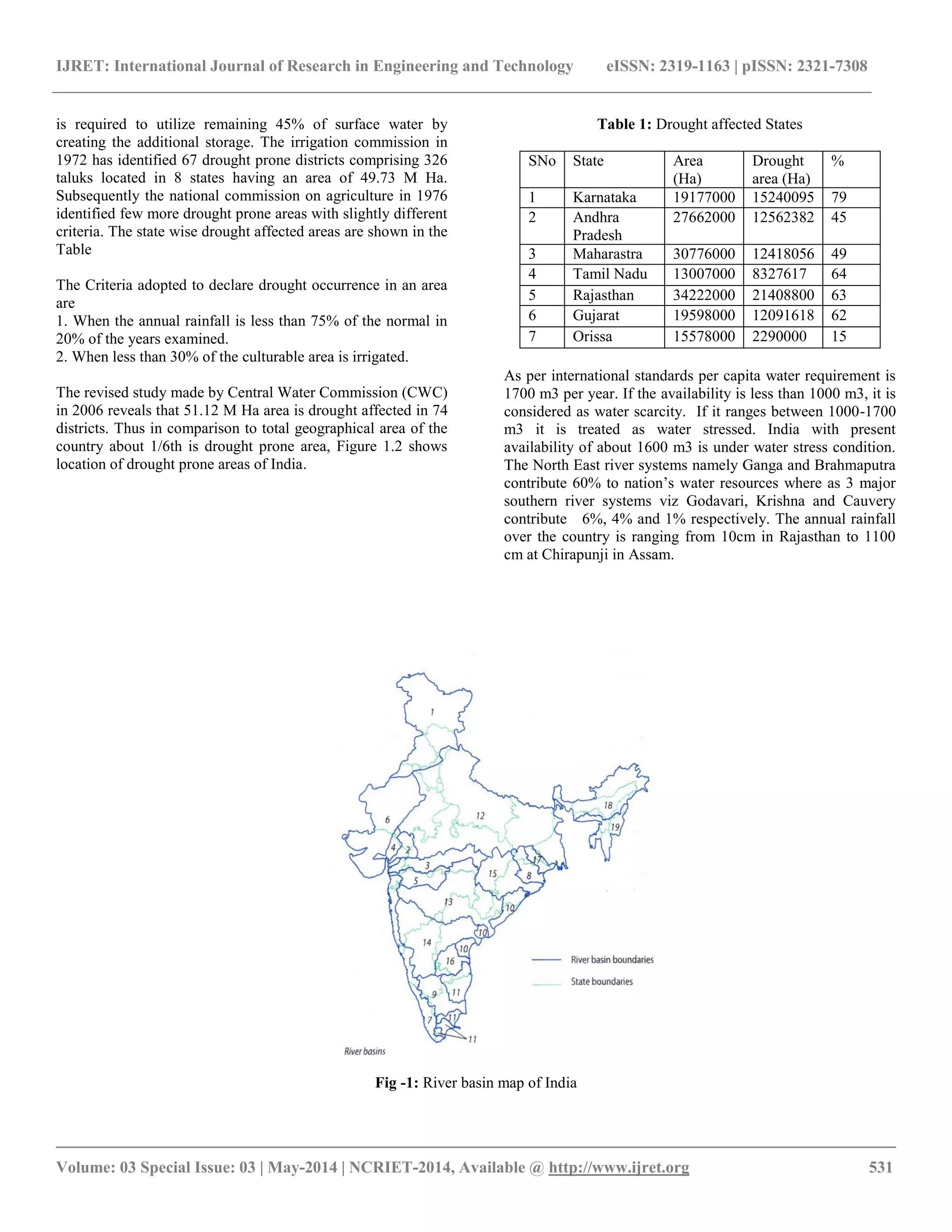
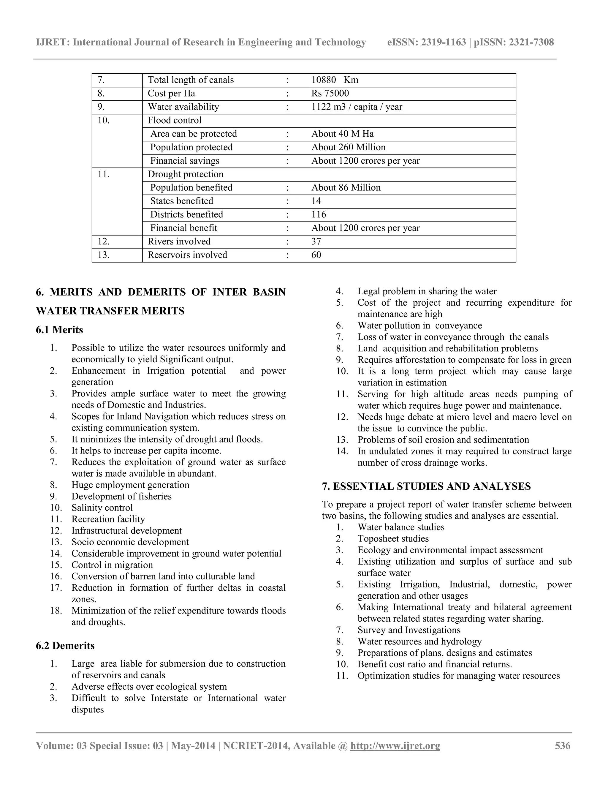
India has 1/6th of the global population and 1/25th of world’s water resources, but the water availability is highly uncertain both in time and space due to its peculiar monsoonal climate. About 70 % of the population directly or indirectly depends on agriculture, in the back drop of economic growth from industrialization. The urban population in the country is increasing at faster rate which requires the establishment of basic infrastructure, amenities and increase in food production. It is essential to convert rain fed crops into irrigation crops. At present the average food production is about 1.4 Ton/Ha which needs to be increased to 3.0 ton/Ha. Out of the net sown area of 140 M Ha, the rain fed area is about 80 M Ha and remaining 60 M Ha is under irrigation. Nearly 78% of water harnessed is being used for irrigation and the balance 22% is used for domestic and Industrial requirements. The basins of Ganga, Brahmaputra, Meghana and west flowing rivers constitute 27% of the drainage area and receive 72% of total rain fall of India. The important river basins of India are shown in Figure and the detail is presented.
The available storage in all reservoirs and tanks is only 55% of available surface water, considering 1.5 times filling. Hence it
2. IJRET: International Journal of Research in Engineering and Technology eISSN: 2319-1163 | pISSN: 2321-7308
__________________________________________________________________________________________
Volume: 03 Special Issue: 03 | May-2014 | NCRIET-2014, Available @ http://www.ijret.org 531
is required to utilize remaining 45% of surface water by creating the additional storage. The irrigation commission in 1972 has identified 67 drought prone districts comprising 326 taluks located in 8 states having an area of 49.73 M Ha. Subsequently the national commission on agriculture in 1976 identified few more drought prone areas with slightly different criteria. The state wise drought affected areas are shown in the Table The Criteria adopted to declare drought occurrence in an area are 1. When the annual rainfall is less than 75% of the normal in 20% of the years examined. 2. When less than 30% of the culturable area is irrigated. The revised study made by Central Water Commission (CWC) in 2006 reveals that 51.12 M Ha area is drought affected in 74 districts. Thus in comparison to total geographical area of the country about 1/6th is drought prone area, Figure 1.2 shows location of drought prone areas of India.
Table 1: Drought affected States
SNo
State
Area (Ha)
Drought area (Ha)
%
1
Karnataka
19177000
15240095
79
2
Andhra Pradesh
27662000
12562382
45
3
Maharastra
30776000
12418056
49
4
Tamil Nadu
13007000
8327617
64
5
Rajasthan
34222000
21408800
63
6
Gujarat
19598000
12091618
62
7
Orissa
15578000
2290000
15
As per international standards per capita water requirement is 1700 m3 per year. If the availability is less than 1000 m3, it is considered as water scarcity. If it ranges between 1000-1700 m3 it is treated as water stressed. India with present availability of about 1600 m3 is under water stress condition. The North East river systems namely Ganga and Brahmaputra contribute 60% to nation’s water resources where as 3 major southern river systems viz Godavari, Krishna and Cauvery contribute 6%, 4% and 1% respectively. The annual rainfall over the country is ranging from 10cm in Rajasthan to 1100 cm at Chirapunji in Assam.
Fig -1: River basin map of India
3. IJRET: International Journal of Research in Engineering and Technology eISSN: 2319-1163 | pISSN: 2321-7308
__________________________________________________________________________________________
Volume: 03 Special Issue: 03 | May-2014 | NCRIET-2014, Available @ http://www.ijret.org 532
1. Indus
6. WFR1
11. EFR2
16. Pennar
2. Mahi
7. WFR2
12. Ganga
17. Subernareka
3. Narmada
8. Brahmani & Baitarani
13. Godavari
18. Brahmaputra
4. Sabarmati
9. Cauvery
14. Krishna
19. Meghana
5. Tapi
10. EFR1
15. Mahanadi
Table 2: Water Resources Of Indian River Basins
SNo
Name of Basin
TRWR Km3
PUWR Km3
Water resources available per capita m3
Surface Water
Ground Water
Total
TRWR
PUWR
1
Indus
73.3
46
14.3
60.3
1501
1235
2
Mahi
11
3.1
3.5
6.6
1649
990
3
Narmada
45.6
34.5
9.4
43.9
2542
2448
4
Sabarmathi
3.8
1.9
2.9
4.8
631
797
5
Tapi
14.9
14.5
6.7
21.2
831
1183
6
WFR1
15.1
15
9.1
24.1
257
409
7
WFR2
200.9
36.2
15.6
51.8
3871
998
8
Brahmani & Baitarani
28.5
18.3
3.4
21.7
1703
1296
9
Cauvery
21.4
19
8.8
27.8
656
852
10
EFR1
22.5
13.1
12.8
25.9
1169
1346
11
EFR2
16.5
16.7
12.7
29.4
423
753
12
Ganga
525
250
136.5
386.5
1418
1044
13
Godavari
110.5
76.3
33.5
109.8
1441
1431
14
Krishna
78.1
58
19.9
77.9
1133
1130
15
Mahanadi
66.9
50
13.6
63.6
2463
2341
16
Pennar
6.3
6.3
4.04
10.9
440
762
17
Subernarekha
12.4
6.8
1.7
8.5
829
568
18
Brahmaputra
585.6
24.3
25.7
48
17661
1448
19
Meghana
48.4
1.7
8.5
10.2
4830
1018
TRWR Total Renewable Water Resources PUWR Potentially Utilizable Water Resources Table 3: Area Liable To Floods
SNo
State
Geographical area (M Ha )
Area liable to flood (M Ha )
%
Area protected ( M Ha )
1
Andhra Pradesh
27.51
1.39
5.05
0.70
2
Assam
7.84
3.15
40.18
1.305
3
Bihar
17.39
4.26
24.50
1.566
4
Gujarat
19.60
1.39
7.09
0.362
5
Haryana
4.42
2.35
53.17
1.095
6
Himachal Pradesh
5.57
0.23
4.13
-----
7
Jammu and Kashmir
22.22
0.08
0.36
0.012
8
Karnataka
19.18
0.02
0.10
0.001
9
Kerala
3.89
0.87
22.37
0.011
10
Madhya Pradesh
44.34
0.26
0.59
-----
11
Maharastra
30.77
0.23
0.75
0.110
4. IJRET: International Journal of Research in Engineering and Technology eISSN: 2319-1163 | pISSN: 2321-7308
__________________________________________________________________________________________
Volume: 03 Special Issue: 03 | May-2014 | NCRIET-2014, Available @ http://www.ijret.org 533
12
Manipur
2.23
0.08
3.59
0.073
13
Meghalaya
2.24
0.02
0.89
0.075
14
Orissa
15.57
1.40
8.99
0.351
15
Punjab
5.04
3.70
73.41
2.407
16
Rajasthan
34.22
3.26
9.53
0.016
17
Tamil Nadu
13.01
0.45
3.46
0.029
18
Tripura
1.05
0.33
31.43
0.009
19
Utter Pradesh
29.44
7.34
44.93
0.739
20
West Bengal
8.88
2.65
29.84
1.001
21
Delhi
0.15
0.05
33.33
0.023
22
Pondicherry
0.05
0.01
20.00
----
Total
33.52
9.776
2. WATER CRISIS SCENARIO IN INDIA The estimated drought prone area is 51.12 M Ha and flood prone area is 33.52 M Ha. By 2025 the estimated per capita availability of water may go down to 1340 m3/year, thus nearly 60% of Indian population will be living in water stress conditions. India produces about 200 Million Tons of food grains to feed the population of about 110 crores. In next 50 years the population is expected to grow to 160 crores, necessitating food production of 450 Million Tons. The country is to gear up to achieve it with proper perspective and vision. The culturable command area in the country is about 184 M Ha and the net sown area is about 140 M Ha. 3. NECESSITY OF THE STUDY As long as spatial and temporal uniformity in occurrence of rainfall is present, the water deficit and excess conditions do not arise. If not, the available water must be utilized properly by storage and transfer so as to satisfy the various needs uniformly over the entire country. In India the monsoons are highly orographic causing floods in North and North Eastern region and drought in other areas. The solution for storage and transfer lies in much talked about interlinking of rivers or inter basin water transfer.[11,12] As the Govt. of India is spending huge amount of money every year towards the relief of floods and drought, it is worthwhile to spend on inter basin and intra basin water transfer schemes keeping long term benefits in view. Moreover the inter basin water transfer is the only solution to maintain regional balance in all sectors like Agricultural, Industrial, Power generation, Domestic, Navigation etc. 4. EXISTING INTER BASIN WATER TRANSFER PROJECTS IN INDIA AND OTHER COUNTRIES The concept of Inter basin water transfer is not new. In fact it was practiced in India and other countries long back and most of the projects of water transfer are still functioning well. Consequently many projects of large scale water transfer have been planned and some of them are implemented.
Examples of Inter basin water transfer in India
Periyar - Vaigai project (Kerala state 1985)
Kurnool – - Cuddapah Canal ( Andhra Pradesh 1863-1870)
Parambikulam - Aliyar project (1962-82)
Telugu – - Ganga project
Beas – - Sutlej Link (1983)
Indira Gandhi Nahar project ( Rajasthan canal, 1958)
Sarada - Sahayak Project (1960 )
Ramganga – - Ganga Link (1978)
Tungabhadra – - Pennar project
Mahi project
Tehri Multipurpose project
Other Countries CANADA: In Canada 16 inter basin water transfer schemes have been implemented for hydropower development. USA: In United States, the California state water project, first phase of which was completed in 1973, provides for the diversion of 4 Km3 of flow from surplus Northern California to the deficit central and southern parts of the state. CHINA: In China there are schemes existing from ancient times which are recently supplemented by modern construction techniques. Now China is also planning for transfer of 48 BCM of water from South to North through a Grand Canal close to Eastern coast. Recently completed projects in China include Biliuha-Dalian inter basin water supply system. U.S.S.R: Among the Inter basin water transfer projects planned and implemented in USSR, the notable scheme executed in the central Kazakistana is Irtysh Karganda scheme 5. NEW PROPOSALS FOR INTER BASIN WATER TRANSFER IN INDIA
The concept of Interlinking of rivers was initially proposed by Sir Arthur Cotton in the year 1850 for Inland navigation purpose. Later in 1972 the then Central Irrigation Minister Dr
5. IJRET: International Journal of Research in Engineering and Technology eISSN: 2319-1163 | pISSN: 2321-7308
__________________________________________________________________________________________
Volume: 03 Special Issue: 03 | May-2014 | NCRIET-2014, Available @ http://www.ijret.org 534
K.L.Rao proposed Ganga-Cauvery link. In 1977 Captain Dastur proposed Garland of canal around the Himalayan, Central and Peninsular India. Later, Ministry of Water Resources and Central Water Commission formulated a National Perspective Plan (NPP) in 1980 to study water resources development in the country and transfer of water from surplus basin to deficit one [3] to minimize regional imbalance. NWDA (National Water Development Agency) was formed under NPP to further investigate and explore the possibilities of interlinking of rivers [6]. The broad objectives of NWDA [2] are
1. To promote systematic and scientific study of interlinking of rivers.
2. To carryout detailed study, survey, investigations of Peninsular and Himalayan rivers.
3. To identify possible water transfer projects/links to carry water from surplus basin to deficit one after meeting the existing and proposed needs.
4. To prepare feasibility reports of various components of Himalayan and Peninsular rivers.
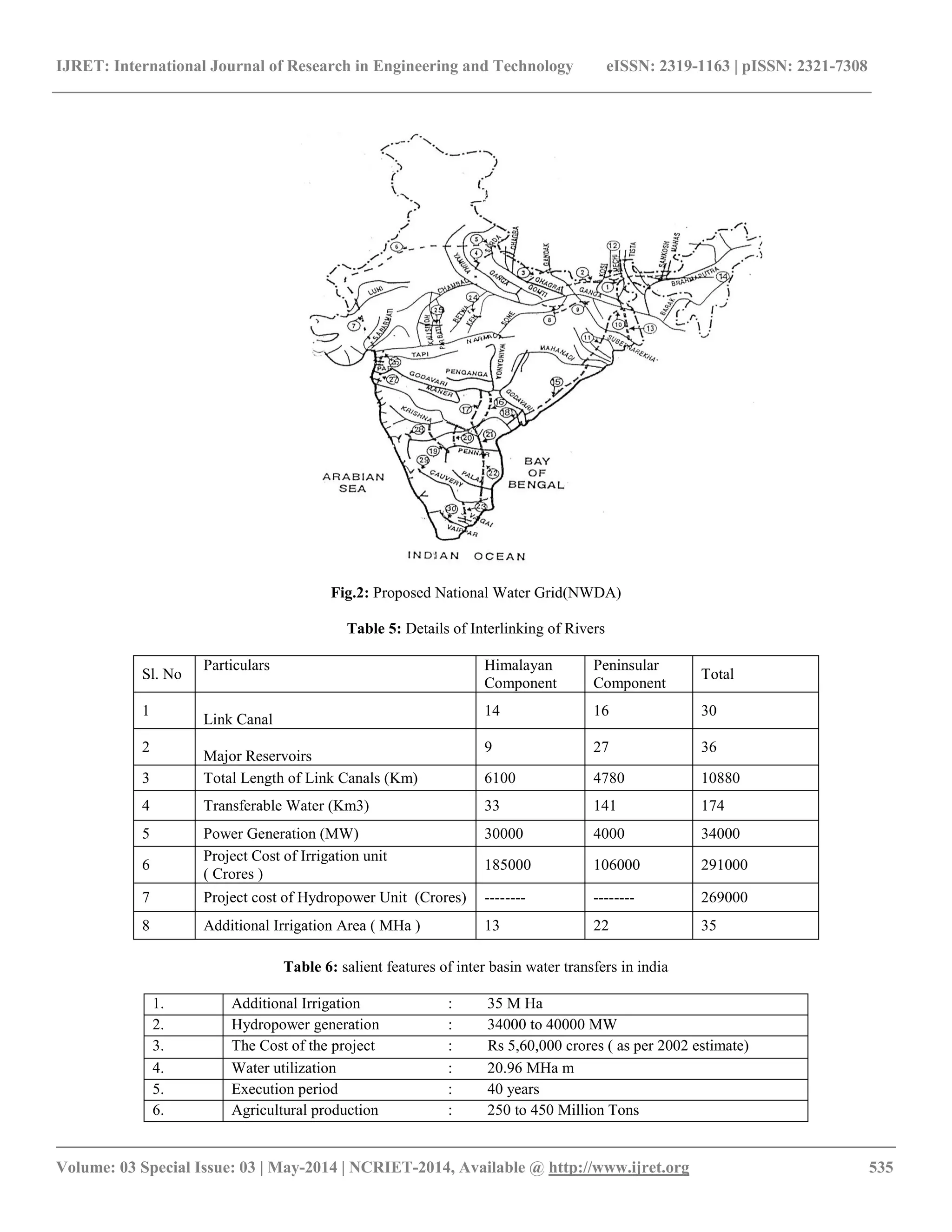
After thorough investigations NWDA proposed to transfer 173 BCM of water through 12,500 Km length of canal. As per NWDA, Inter basin water transfer is proposed in two components namely (1) Himalayan component and (2) Peninsular component. The proposed national water grid is given in Figure below. In this figure numbers 1-30 refer to the links considered under Himalayan (1-14) and Peninsular (15- 30) components as listed below. 5.1 Himalayan Component This component mainly proposes to link Brahmaputra and its tributaries with the river Ganga and Ganga with Mahanadi. In addition it also proposes to transfer surplus flows of the Eastern tributaries of Ganga to the West. This component envisages construction of canal systems and storage reservoirs on the principal tributaries of Ganga and Brahmaputra rivers in India, Nepal and Bhutan. This component would provide additional irrigation to about 22 MHa and power generation of about 30000 MW besides flood control in Brahmaputra and Ganga basins. The 14 links of Himalayan component are Table 4: Himalayan Component
5.2 Peninsular Component In this component a network of interconnected river basins of Peninsular India is considered. NWDA carried out water balance studies of all the major river basins such as Mahanadi , Godavari , Krishna ,Pennar , Cauvery , Vaigai, West flowing rivers of Kerala , Karnataka , North of Bombay and South of Tapi and Southern tributaries of Yamuna to find out water surplus and deficit basins. The 16 links of Peninsular component are given below. From Peninsular Component it is possible to irrigate about 13 M Ha and about 4000 MW of Hydropower can be generated. The Peninsular component utilizes 69.6 TMCum of water. This component involves the construction of storage reservoirs at potential sites in addition to the existing /ongoing reservoirs and a network of canals for water transfer. The following Table gives the details of proposed Interlinking of rivers
1 Brahmaputra-Ganga
6 Yamuna-Rajastana
2 kosi-Ghagra
7 Rajastana-Sabaramati
3 Gandak-Ganga
8 Chemar- Sone barrage link
4 Ghagra- Yamuna
9 Sone dam-southern Ganga
5 Sarada-Yamuna
10 Ganga –Damodar – Subernarekha
11Subernarekha- Mahanadi
13 Farakka-Sunderban
12 Kosi-Mechi
14 Brahmaputra-Ganga(Jogighopa- Tista-Farakka)
15.Mahanadi (Manibhadra) - Godavari (Dowleswaram) Link
23.Cauvery (Kattalai) - Vaigai - Gundar Link
16.Godavari (Inchampalli) - Krishna (Nagarjunasagar) Link
24.Ken - Betwa Link
17.Godavari (Inchampalli Low Dam) - Krishna (Nagarjunasagar Tail pond) Link
25.Parbathi - kalisindh Link
18.Godavari (Polavaram) - Krishna (Vijayawada Link)
26.Par - Tapi - Narmada
19.Krishna (Almatti) - Pennar (Bukkapatnam) Link
27.Damanganga - Pinjal Link
20.Krishna (Srisailam) - Pennar (Mylavaram )Link
28.Bedti - Varda Link
21.Krishna (Nagarjunasagar) - Pennar (Somasila)Link
29.Netravathi - Hemavathi Link
22.Pennar (Somasila) - Cauvery (Grand Anicut) Link
30.Pamba-Achankovil - Vaippar Link
6. IJRET: International Journal of Research in Engineering and Technology eISSN: 2319-1163 | pISSN: 2321-7308
__________________________________________________________________________________________
Volume: 03 Special Issue: 03 | May-2014 | NCRIET-2014, Available @ http://www.ijret.org 535
Fig.2: Proposed National Water Grid(NWDA) Table 5: Details of Interlinking of Rivers
Sl. No
Particulars
Himalayan Component
Peninsular Component
Total
1
Link Canal
14
16
30
2
Major Reservoirs
9
27
36
3
Total Length of Link Canals (Km)
6100
4780
10880
4
Transferable Water (Km3)
33
141
174
5
Power Generation (MW)
30000
4000
34000
6
Project Cost of Irrigation unit ( Crores )
185000
106000
291000
7
Project cost of Hydropower Unit (Crores)
--------
--------
269000
8
Additional Irrigation Area ( MHa )
13
22
35
Table 6: salient features of inter basin water transfers in india
1.
Additional Irrigation
: 35 M Ha
2.
Hydropower generation
: 34000 to 40000 MW
3.
The Cost of the project
: Rs 5,60,000 crores ( as per 2002 estimate)
4.
Water utilization
: 20.96 MHa m
5.
Execution period
: 40 years
6.
Agricultural production
: 250 to 450 Million Tons
7. IJRET: International Journal of Research in Engineering and Technology eISSN: 2319-1163 | pISSN: 2321-7308
__________________________________________________________________________________________
Volume: 03 Special Issue: 03 | May-2014 | NCRIET-2014, Available @ http://www.ijret.org 536
7.
Total length of canals
: 10880 Km
8.
Cost per Ha
: Rs 75000
9.
Water availability
: 1122 m3 / capita / year
10.
Flood control
Area can be protected
: About 40 M Ha
Population protected
: About 260 Million
Financial savings
: About 1200 crores per year
11.
Drought protection
Population benefited
: About 86 Million
States benefited
: 14
Districts benefited
: 116
Financial benefit
: About 1200 crores per year
12.
Rivers involved
: 37
13.
Reservoirs involved
: 60
6. MERITS AND DEMERITS OF INTER BASIN WATER TRANSFER MERITS 6.1 Merits
1. Possible to utilize the water resources uniformly and economically to yield Significant output.
2. Enhancement in Irrigation potential and power generation
3. Provides ample surface water to meet the growing needs of Domestic and Industries.
4. Scopes for Inland Navigation which reduces stress on existing communication system.
5. It minimizes the intensity of drought and floods.
6. It helps to increase per capita income.
7. Reduces the exploitation of ground water as surface water is made available in abundant.
8. Huge employment generation
9. Development of fisheries
10. Salinity control
11. Recreation facility
12. Infrastructural development
13. Socio economic development
14. Considerable improvement in ground water potential
15. Control in migration
16. Conversion of barren land into culturable land
17. Reduction in formation of further deltas in coastal zones.
18. Minimization of the relief expenditure towards floods and droughts.
6.2 Demerits
1. Large area liable for submersion due to construction of reservoirs and canals
2. Adverse effects over ecological system
3. Difficult to solve Interstate or International water disputes
4. Legal problem in sharing the water
5. Cost of the project and recurring expenditure for maintenance are high
6. Water pollution in conveyance
7. Loss of water in conveyance through the canals
8. Land acquisition and rehabilitation problems
9. Requires afforestation to compensate for loss in green
10. It is a long term project which may cause large variation in estimation
11. Serving for high altitude areas needs pumping of water which requires huge power and maintenance.
12. Needs huge debate at micro level and macro level on the issue to convince the public.
13. Problems of soil erosion and sedimentation
14. In undulated zones it may required to construct large number of cross drainage works.
7. ESSENTIAL STUDIES AND ANALYSES To prepare a project report of water transfer scheme between two basins, the following studies and analyses are essential.
1. Water balance studies
2. Toposheet studies
3. Ecology and environmental impact assessment
4. Existing utilization and surplus of surface and sub surface water
5. Existing Irrigation, Industrial, domestic, power generation and other usages
6. Making International treaty and bilateral agreement between related states regarding water sharing.
7. Survey and Investigations
8. Water resources and hydrology
9. Preparations of plans, designs and estimates
10. Benefit cost ratio and financial returns.
11. Optimization studies for managing water resources
8. IJRET: International Journal of Research in Engineering and Technology eISSN: 2319-1163 | pISSN: 2321-7308
__________________________________________________________________________________________
Volume: 03 Special Issue: 03 | May-2014 | NCRIET-2014, Available @ http://www.ijret.org 537
8. CONCLUSIONS The hydrological extremes of floods and droughts will have adverse effects on social and economical development of a country or region. The unique and long term solution for dual problem is inter basin water transfer. The study proves to be an authentic reference and resource for the planners, field engineers, administrators, researchers and the general public dealing with water resource exploitation, utilization and transfer. The following conclusions are drawn out of this work. The next 50 years in India would witness a very large growth of urban centers. Many large urban centers would grow into metropolitan centers and meeting their water requirements would pose new challenges. The food production has to grow proportionally necessitating more allocation of water for irrigation. The inter basin water transfer proves to be the best option for the policy planners, administrators, professionals, media, NGO’s and public to meet the challenges of the future. The entire surface water resource of the country is to be treated as national property so as to make its development and utilization uniform for the overall development of the country. Remote sensing and GIS tools can be utilized to carry out the hydrological, drainage, seepage and socio-economic analysis and the environmental impact assessment of the proposed water transfer projects. The basins of the water transfer scheme can be studied by developing digital elevation models (DEM) which help to generate the stream networks map, slope and aspect ratios of the basins. REFERENCES
[1] Jonathan L Chenoweth, Hector M. Malano & Juliet. F. Bird “Integrated River Basin management in the Multi- Jurisdictional River Basin: The Case of the Mekong River Basin” Journal of Water Resources Development vol 17, No 3, 2001, P 365-377
[2] NWDA (National Water Development Agency) India “A study on Inter- basin Water Transfer in India”
[3] Rajiv K Gupta “Human Rights Dimension of Regional Water Transfer: Experience of the Sardar Sarovar Project” Journal of Water Resources Development Vol 17, No 1, 2001, P 125-147
[4] Dr A.K.Chakraborty “Interlinking of Rivers – How can we use Space Technology to Resolve Survey & Investigation Issues” National Seminar on Inter-Basin transfer of water in India – Prospects and Feasibility”, P 10.1-10.5
[5] S.V.Chitale “Inter-basin Transfer by Water Grid Caution and Precaution”– The Indian Society for Hydraulics, Journal of Hydraulic Engineering , 2006, Vol 12(2), P 1-6
[6] Ramaswamy. R.Iyer “Linking of Rivers: Vision or mirage?” Published in India’s National Magazine, The Publication of The Hindu – Vol 19 December 2002, Issue 25, P 1-7
[7] W.G.Yeh “Reservoir Management and Operational Models” A state – of – the Art Review, Water Resources Research, Vol 21, 1985, P 1797-1818
[8] Charles Revelle, Edward Joeres and William Kirby “The linear Decision rule in reservoir management and decision Development of the stochastic model” Water Resources Research, Vol 4,1969, P 767-777
[9] K.Can and Mark H.Houck “Real-Time Reservoir Operation by Goal Programming” Journal of Water Resource Planning and Management, ASCE Vol 110, 1984, P 297-309
[10] Slobodam,P.Simonovi “Reservoir System Analysis: Closing Gap between theory and Practice” Journal of Water Resources Planning and Management ASCE , Vol 118,1992, P 262-280
[11] H.Mahabaleswara & G.Abbaiah “Inter-basin Water Transfers and Resolving Conflicts” International Conference on Hydrology and Watershed Management, 5-8 December 2006, Hyderabad
[12] H.Mahabaleswara, Dr.G.Abbaiah “Interlinking of Rivers” National Conference on Hydraulics and Water Resources with Special emphasis on Interlinking of Rivers, held at Bharathi Vidyapeetha Deemed University College of Engineering, Pune (Maharashtra –India ) 8-9 December 2006