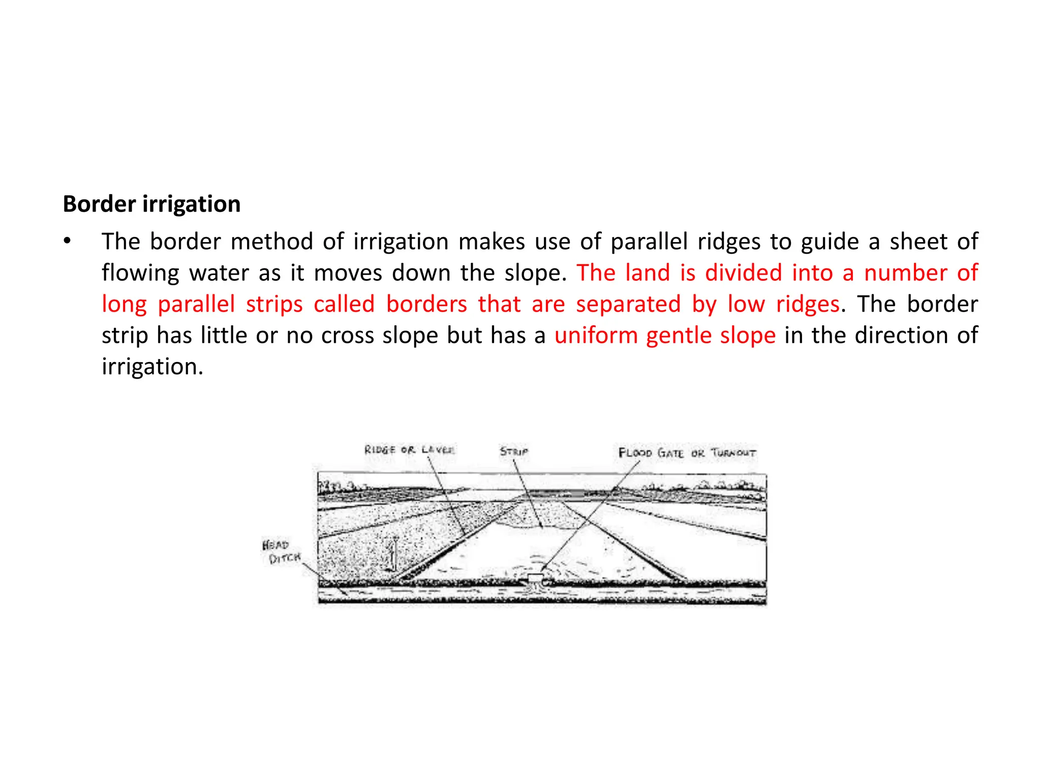
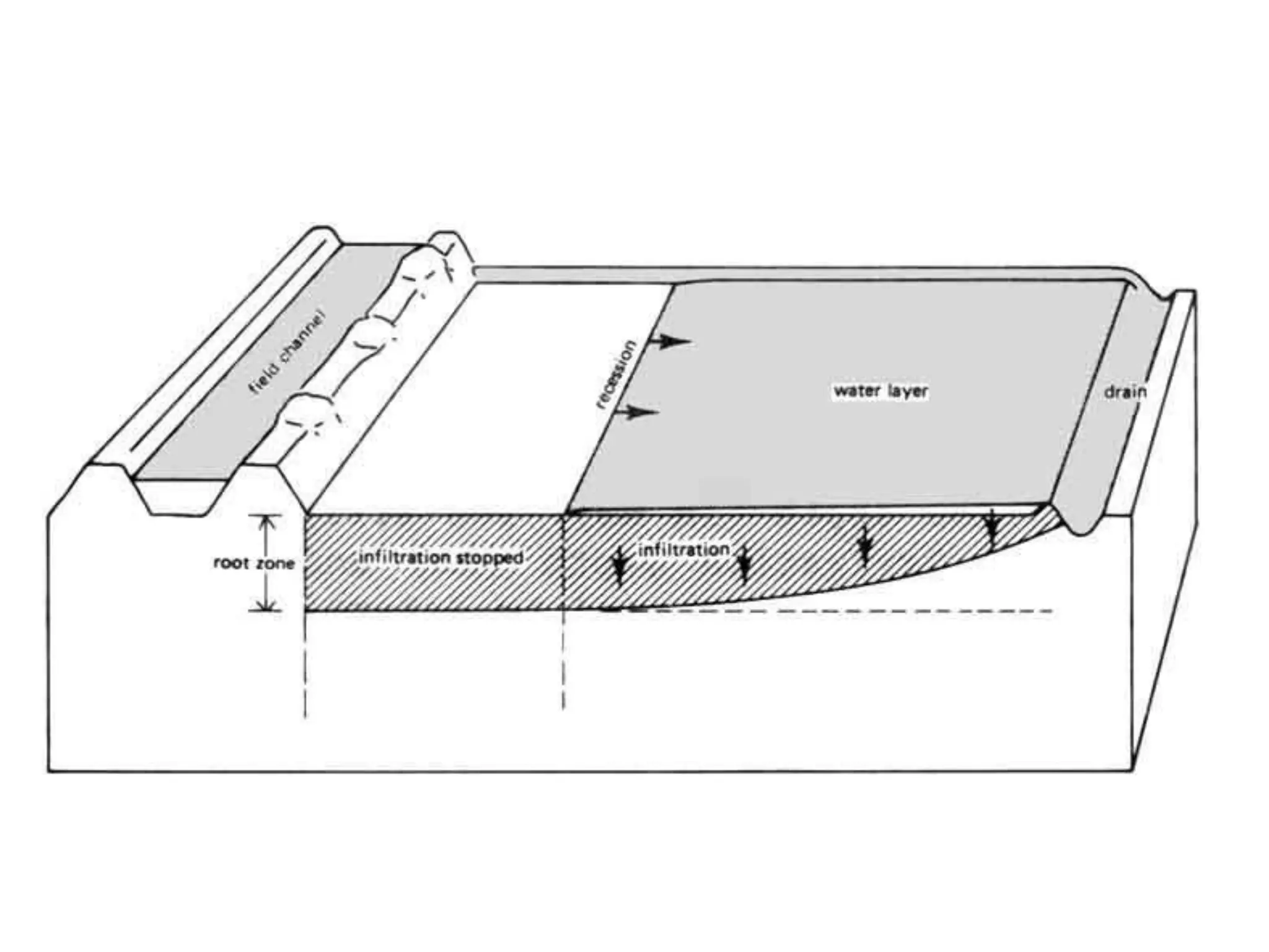
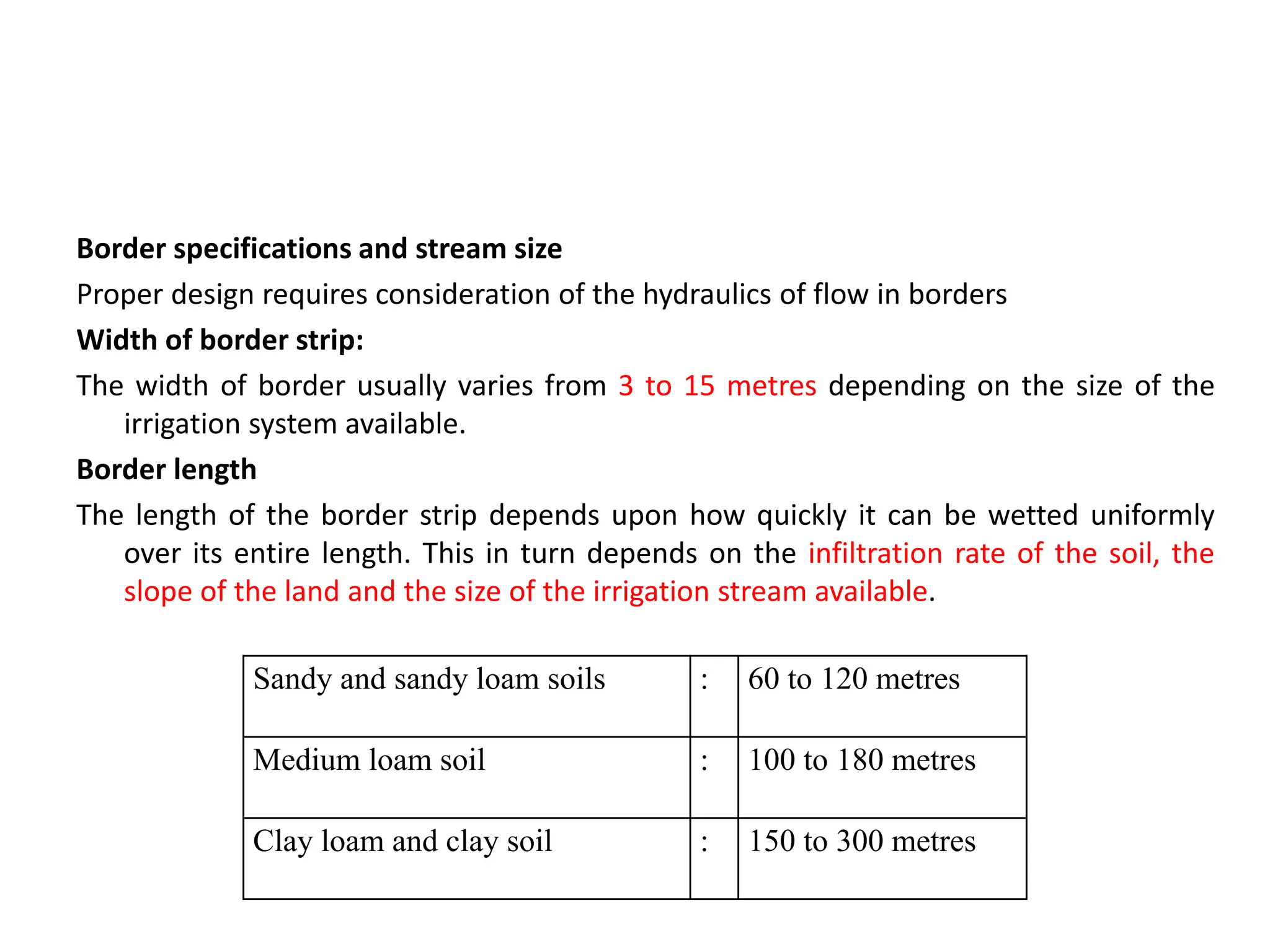
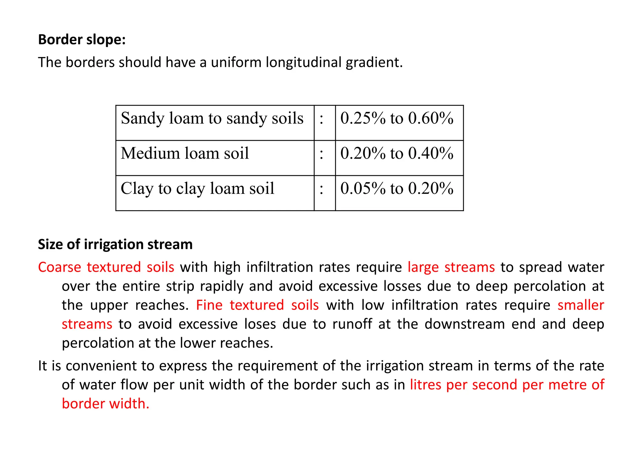
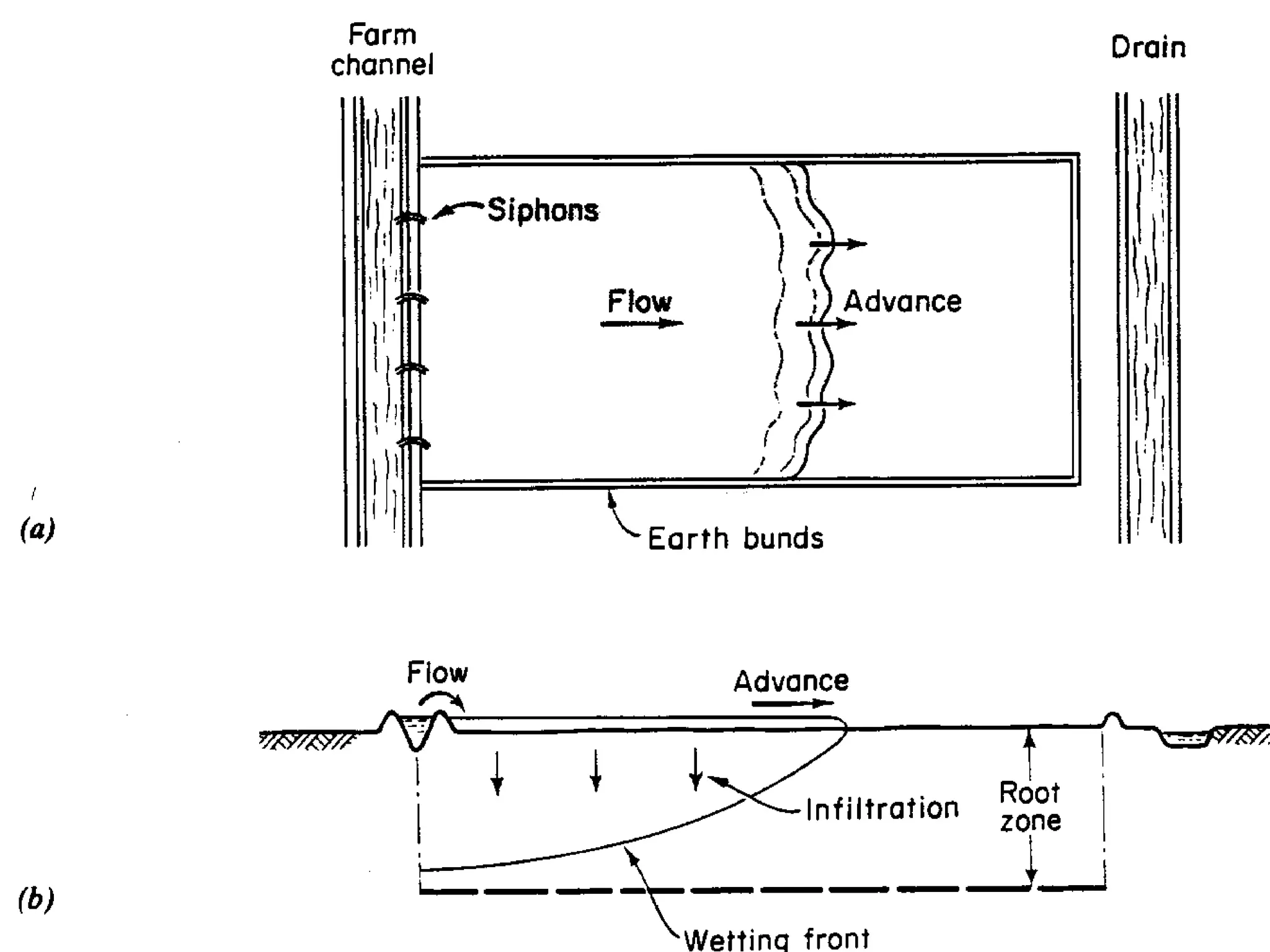
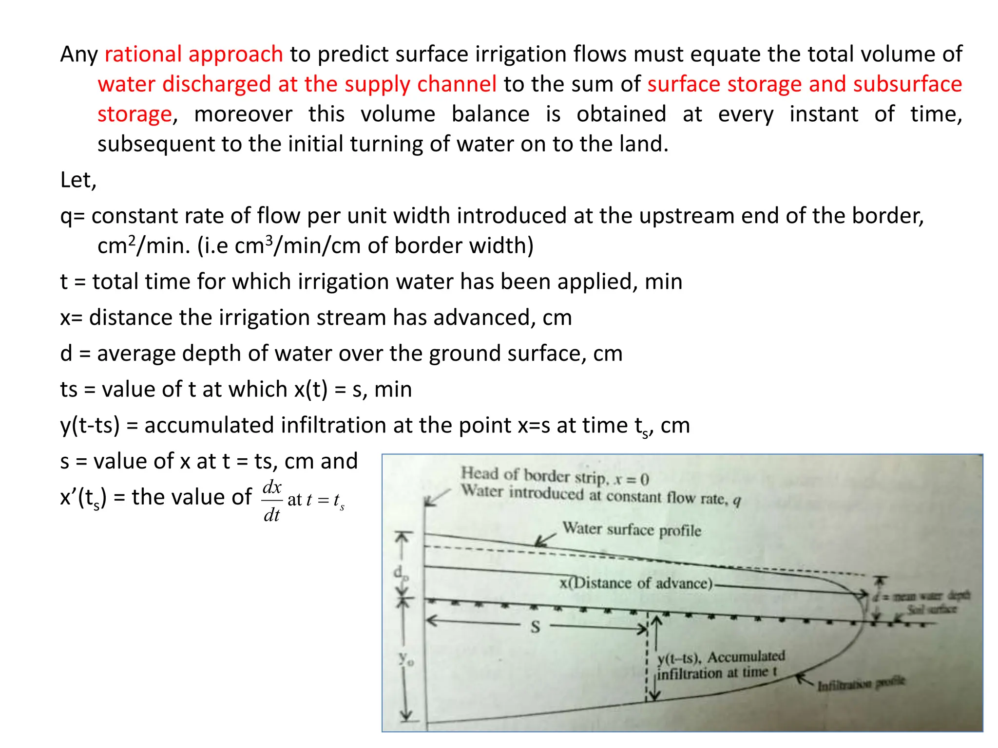
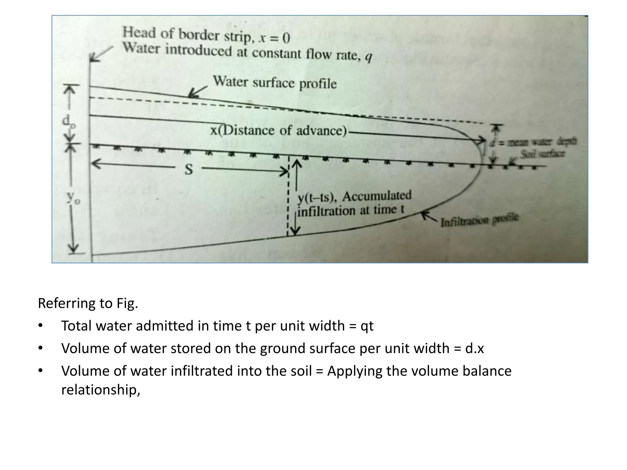
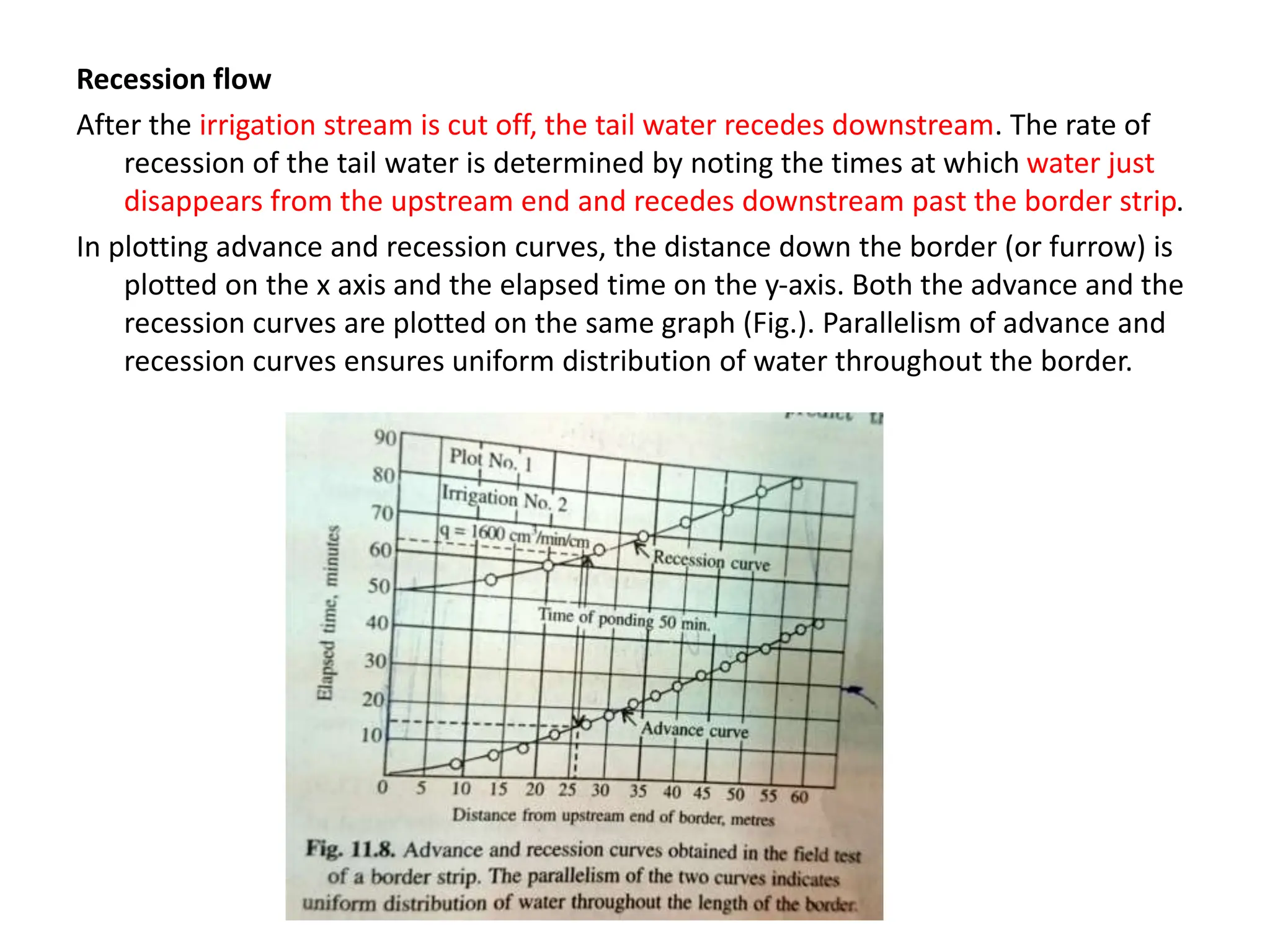
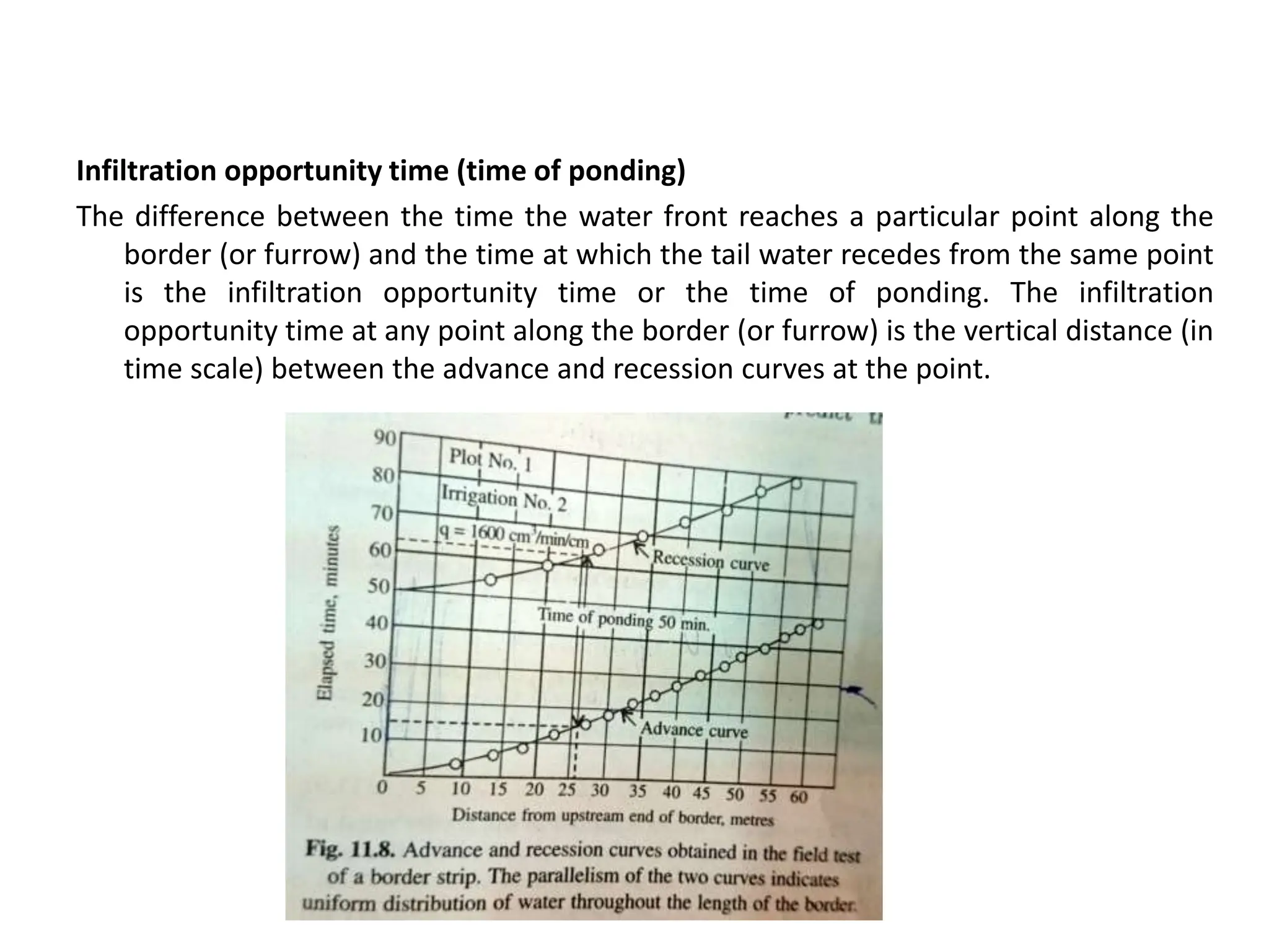
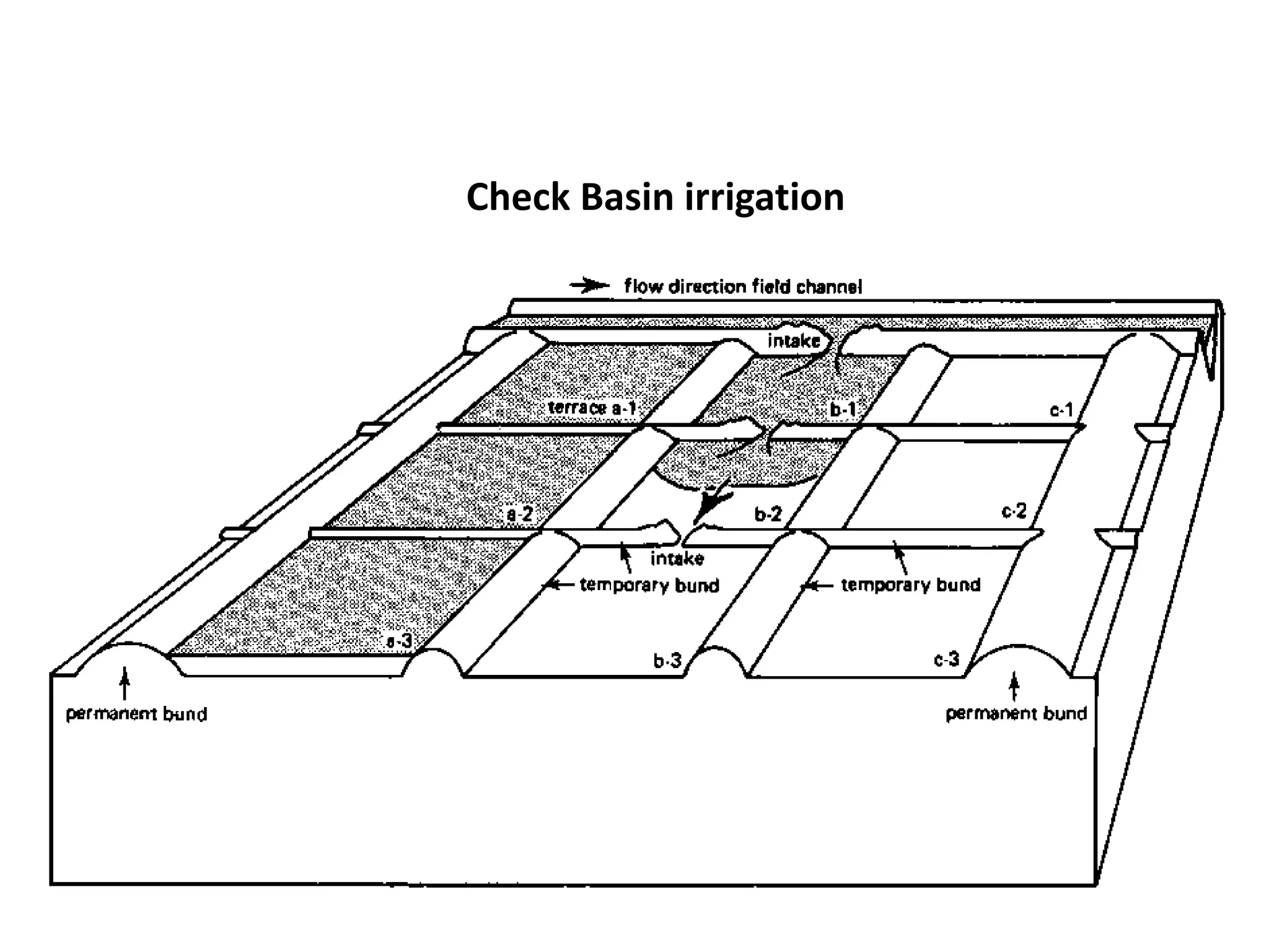
2. Border irrigation
• The border method of irrigation makes use of parallel ridges to guide a sheet of
flowing water as it moves down the slope. The land is divided into a number of
long parallel strips called borders that are separated by low ridges. The border
strip has little or no cross slope but has a uniform gentle slope in the direction of
irrigation.
3.
4. • Each strip is irrigated independently by turning in a stream of water at the upper
end. The water spreads and flows down the strip in a sheet confined by the border
ridges. When the advancing waterfront reaches the lower end, a few minutes
before or after that the stream is turned off. The water temporarily stored in the
border moves down the strip and infiltrates, thus completing the irrigation.
Borders are of two types:
• (i) Open end borders and (ii) Blocked end borders
• Border irrigation method is suitable to soils having moderately low to moderately
high infiltration rates. Usually it is not used in coarse sandy soils that have very
high infiltration rates. The size of irrigation stream per unit width of border strip
must be larger as compared to other methods of surface irrigation.
• The border method is suitable to irrigate all close growing crops like wheat, barley,
fodder crops and legumes. It is however, not suitable for crops like rice.
5. Advantages of border irrigation
• Border ridges can be constructed economically with simple farm implements like a
bullock drawn A-frame ridger or bund former or tractor drawn disc ridger.
• Labour requirement in irrigation is reduced as compared to check basin method of
irrigation.
• Uniform distribution and high water application efficiencies are possible if the
system is properly designed.
• Large irrigation streams can be efficiently used
• Operation of the system is simple and easy
6. Border specifications and stream size
Proper design requires consideration of the hydraulics of flow in borders
Width of border strip:
The width of border usually varies from 3 to 15 metres depending on the size of the
irrigation system available.
Border length
The length of the border strip depends upon how quickly it can be wetted uniformly
over its entire length. This in turn depends on the infiltration rate of the soil, the
slope of the land and the size of the irrigation stream available.
Sandy and sandy loam soils : 60 to 120 metres
Medium loam soil : 100 to 180 metres
Clay loam and clay soil : 150 to 300 metres
7. Border slope:
The borders should have a uniform longitudinal gradient.
Size of irrigation stream
Coarse textured soils with high infiltration rates require large streams to spread water
over the entire strip rapidly and avoid excessive losses due to deep percolation at
the upper reaches. Fine textured soils with low infiltration rates require smaller
streams to avoid excessive loses due to runoff at the downstream end and deep
percolation at the lower reaches.
It is convenient to express the requirement of the irrigation stream in terms of the rate
of water flow per unit width of the border such as in litres per second per metre of
border width.
Sandy loam to sandy soils : 0.25% to 0.60%
Medium loam soil : 0.20% to 0.40%
Clay to clay loam soil : 0.05% to 0.20%
8. Hydraulics of border irrigation:
The flow in a border strip is a case of spatially varied unsteady open channel flow
with decreasing discharge. The discharge rate decreases downstream due to
infiltration.
The dominant variables influencing border irrigation are – (i) size of irrigation stream,
(ii) slope of the land surface, (iii) infiltration characteristics of the soil and (iv) the
resistance to flow offered by the soil surface and vegetative cover.
A complete analysis of border irrigation would require information on the effect of
land slope, infiltration, roughness of soil surface, vegetation and depth of water on
the velocity of flow down the slope.
10. Any rational approach to predict surface irrigation flows must equate the total volume of
water discharged at the supply channel to the sum of surface storage and subsurface
storage, moreover this volume balance is obtained at every instant of time,
subsequent to the initial turning of water on to the land.
Let,
q= constant rate of flow per unit width introduced at the upstream end of the border,
cm2/min. (i.e cm3/min/cm of border width)
t = total time for which irrigation water has been applied, min
x= distance the irrigation stream has advanced, cm
d = average depth of water over the ground surface, cm
ts = value of t at which x(t) = s, min
y(t-ts) = accumulated infiltration at the point x=s at time ts, cm
s = value of x at t = ts, cm and
x’(ts) = the value of s
t
t
dt
dx
at
11. Referring to Fig.
• Total water admitted in time t per unit width = qt
• Volume of water stored on the ground surface per unit width = d.x
• Volume of water infiltrated into the soil = Applying the volume balance
relationship,
12. y is the function of (t-ts) and
x is a function of ts
………………. (1)
This equation was proposed by Lewis and Milne (1938)
Philip and Farrel (1964) using the Faltung or convolution theorem of Laplace transformation obtained the
general solution of equation as follows.
…………………….. (2)
This equation (2) represents the general solution of equation (1)
Field tests on infiltration at pre-sowing and post emergence irrigations indicate that the
functional relationship between accumulated infiltration and elapsed time can be
expressed best by the following empirical formula:
In which,
y = accumulated infiltration at time t, cm
t = elapsed time, minutes and
a, and b are characteristics constants
x
yds
x
d
qt
0
.
t
s
s
s
x
dt
t
x
t
t
y
yds
0
0
)
(
'
)
(
2
3
1 1
ds
y
L
s
L
q
x
b
at
y
0
,
1
0
t
a
t
s
s
s dt
t
x
t
t
y
dx
qt
0
)
(
'
)
(
13. Recession flow
After the irrigation stream is cut off, the tail water recedes downstream. The rate of
recession of the tail water is determined by noting the times at which water just
disappears from the upstream end and recedes downstream past the border strip.
In plotting advance and recession curves, the distance down the border (or furrow) is
plotted on the x axis and the elapsed time on the y-axis. Both the advance and the
recession curves are plotted on the same graph (Fig.). Parallelism of advance and
recession curves ensures uniform distribution of water throughout the border.
14. Infiltration opportunity time (time of ponding)
The difference between the time the water front reaches a particular point along the
border (or furrow) and the time at which the tail water recedes from the same point
is the infiltration opportunity time or the time of ponding. The infiltration
opportunity time at any point along the border (or furrow) is the vertical distance (in
time scale) between the advance and recession curves at the point.
15. Design of border irrigation:
To obtain the maximum water application efficiency the water should remain on the
surface sufficiently long to allow just the desired amount of water to infiltrate into
the soil. The required infiltration opportunity time is obtained using the
accumulated infiltration time relationship for the soil.
Water distribution efficiency is governed mainly by the uniformity of the infiltration
opportunity time obtained throughout the border length. When the behavior of the
irrigation system can be predicted from the measurable characteristics of the site, it
is possible to obtain a nearly uniform infiltration opportunity time throughout the
border by suitably adjusting the entrance stream size, and the length of run or slope
of the border.
16. Procedure for efficient border irrigation system
(1) The length, width and slope of the border strip are determined
(2) The depth of water required to replenish the soil moisture in the root zone of the
crop to field capacity is estimated.
(3) The accumulated infiltration time relationship of the soil under the existing soil
conditions and vegetation is determined. The relationship can be established by
actual measurements with cylinder infiltrometers before each irrigation.
(4) The desired infiltration opportunity time is determined
(5) The hydraulic resistance is estimated on the basis of the soil surface roughness and
the hydraulic characteristics of the crop.
(6) The average depth of flow is estimated.
(7) The water front advance is predicted. The water front advance time relationship as a
function of the entrance stream sixe, average depth of flow and infiltration
characteristics.
(8) The irrigation system is designed to obtain the optimum water application efficiency
and border length.
18. Check basin
Bunds or ridges are constructed around the areas forming basins within which the
irrigation water can be controlled.
Design considerations
Water is conveyed to the field by a system of supply channels and lateral field channels. The
supply channel is aligned on the upper side of the area and there is usually one lateral for
every two rows of check basins. Water from the laterals is turned into the beds and is cut
off when sufficient water has been admitted to the basin. Water is retained in the basin
until it seeps into the soil.
Types of check basins, based on size and shape:
The size of the check basins may vary from 1 sq.m, used for growing vegetables to as large
as one or two hectares or more, used for growing rice under wetland conditions.
The vertical interval between contour ridges usually varies from 6 to 12 cm in case of upland
irrigated crops like wheat and 15 to 30 cm in case of lowland irrigated crops like rice.
Sandy and sandy loam soils with high infiltration rates permit only small size basins while clay
soils having low infiltration rates allow large basins.
In irrigating orchards, square or contour basins may be used. When the plants are widely
spaced, the ring method of basin irrigation may be adopted. The rings are circular basins
formed around each tree.
19. Adaptability:
Check basin irrigation is suited for smooth gentle and uniform land slopes and for
soils having moderate to low infiltration rates.
Check basins are useful when leaching is required to remove salts from the soil
profile.
Hydraulics of check basin:
Hydraulics of flow in check basins may be considered to comprise of four stages.
1. Initial spreading of the entrance stream to cover the full width of the basin and
simultaneous advance of the irrigation stream.
2. Advance of the water front after the initial spreading
3. Rise of water level after the advancing stream reaches the downstream end, and
4. Subsidence of water after the irrigation stream is stopped.
20. Essential difference between border irrigation and check basin irrigation:
The essential differences in the phenomenon are in the initial spreading of the entrance
stream to cover the full width of the basin and in the characteristics of the recession
flow.
(i) Spreading the entrance stream in a check basin:
The water front advance in a check basin differs from borders in the initial stages at the
upstream end of the basin. The entrance stream spreads on either side as it
advances forward till the entire width of the basin is covered. When the water is
introduced into a check basin from an orifice or other inlets, the flow is non-linear.
In non-linear flow, the paths of flow may diverge or converge along the flow line.
(ii) Water front advance in check basins:
The advance of the water front after the initial spreading in check basins is similar to
border irrigation method. The dominant variables are the same as in borders,
namely entrance stream size, infiltration characteristics of the soil, hydraulic
resistance offered by the soil surface and vegetation, water surface slope and
elapsed time.
21. (iii) Water storage and rate of rise in check basins:
Ponding occurs after the water front reaches the downstream end of the check basin.
The volume of storage above the soil surface in a given time period is equal to the
difference between the volume of water admitted into the basin during the period
and the volume infiltrated into the soil. This may be expressed as
In which
Vs = volume of water stored in a given time ts, cm3
q = average size of the entrance stream, cm3/min
ts = storage time, min
Is = average infiltration rate during the storage time, cm3/min
Ac = area of check basin, cm2 and
ds = depth of storage during ts, cm
s
c
s
s
s
s d
A
t
I
qt
V
22. (iv) Recession of water in check basins
Recession in a check basin may be taken as the subsidence of water due to infiltration.
The recession rate can be estimated with the help of the infiltration equation
Design of check basin irrigation system:
Efficient irrigation by the check basin method depends on the knowledge of the
hydraulics of flow in the basin. A useful thumb rule in check basin design is that
the water spread in the entire basin should be covered in one-fourth of the time
required to infiltrate the net depth of irrigation water. This is often called the
quarter time rule.
Quasi-rational designs of check basins may be developed using the procedure
suggested by border irrigation
25. Furrow irrigation
• Furrows are small, parallel channels made to carry water in order to irrigate the crop. The
crop is usually grown on the ridges between the furrows.
26. Cut back stream in furrow irrigation
• A common method to obtain the optimum opportunity time to apply a given
depth of irrigation in a furrow system is to allow the initial design stream to flow
the full length of the furrow and then reduce the stream size by adjusting outlet
gates or by reducing the number or size of spiles or systems to permit reduced
stream size. The furrow stream in such a situation is called the cutback stream.
• The size of the cutback stream is adjusted to match the cumulative infiltration in a
furrow so that there is no runoff at the tail end. The application of the cutback
stream is continued till the time required to fill the crop root zone to the field
capacity of the soil.
27. Advantages of furrow irrigation
• Water in the furrows contacts only one-half to one-fifth of the land surface therby
reducing puddling and crusting of the soil and evaporation losses
• Earlier cultivation is possible
• The method reduces labour requirements in land preparation and irrigation.
• Compared to check basin method, there is no wastage of land in field ditches.
28. • Furrows of 7.5 to 12.5 cm depth are appropriate for vegetable crops, while some
row crops and orchards require much deeper furrows.
• Furrows may be classified into two types based on their alignment. They are: (a)
straight furrows and (b) contour furrows
• Based on their size and spacings, furrows may be classified as deep furrows and
corrugations.
(a) Straight furrows:
• Straight furrows are laid down the prevailing land slpe. They are best suited to
sites where the land slope does not exceed 0.75 per cent.
29. (b) Contour furrows
• Contour furrows carry water across a sloping field rather than down the slope. Field
supply channels run down the land slope to feed the individual furrows. Contour
furrow method can be successfully used in nearly all irrigable soils. The topography
must be uniform enough to permit a head ditch that can feed the entire area of
contour furrows.
• Contour furrows may be used on most soil types, except on light sandy soils and
soils that crack. The ridges between furrows in sandy soils may break and wash out,
overloading the furrow below, which also breaks. This may continue all the way
down the slope causing heavy erosion damage. Soils that crack provide channels for
water causing similar down slope furrow breaks. Hence contour furrows have only
limited use on steep slopes in sandy soils and heavy black soils.
• In heavy rainfall areas the length of furrows should be short enough to dispose off
the runoff safely without breaking the furrows. Erosion control structures are
needed to carry the surplus water down the slope. Contour furrow irrigation used in
conjunction with contour bunding and terracing provides an insurance against
furrow breaks.
30. Corrugation irrigation:
• Corrugation irrigation consists of running water in small furrows, called corrugations
which direct the flow down the slope. It is commonly used for irrigating non
cultivated, close growing crops such as small grains and for pasture growing on steep
slopes. The main point of difference from regular furrow irrigation is that more, but
smaller furrows are utilized and the crop rows are not necessarily related to the
irrigation furrows.
• The corrugations can be made with a simple bamboo corrugator or cultivators
equipped with small furrowers or other similar implements.
• Corrugations are V shaped or U shaped channels about 6 to 10 cm deep, spaced 40
to 75 cm apart. The entire soil surface is wetted slowly by the capillary movement of
the water which flows in the corrugations. Corrugation irrigation is most suitable in
loamy soils in which the lateral movement of water takes place readily. Clay soils with
low infiltration rates are difficult to irrigate by this method, unless the slopes are
quite flat. It is also not suitable in deep sandy soils because of the excessive loss of
water by deep percolation.
• The corrugation method is not recommended on saline soils or when the irrigation
water has a high salt content. The permissible length of corrugations varies from
about 50 m in light textured soils with slopes of 2% to 4% to about 150 m in heavy
textured soils up to 2% slope.
32. Furrow irrigation hydraulics:
• The flow phenomenon in furrow irrigation is a case of unsteady open channel flow
with decreasing discharge. Furrow irrigation however, differs from borders and
basins in the pattern of wetting the soil, because the water which soaks into the
soil spreads laterally to the adjacent areas.
• The dominant variables influencing the rate of flow in furrows are the entrance
stream size, infiltration rate, size and shape of wetted section of furrow, furrow
slope and hydraulic resistance. The hydraulic resistance to flow may be due to the
combined effect of the roughness offered by the wetted surface of the furrow and
the resistance offered by the crop.
• As in borders, the time of ponding or infiltration opportunity time in a furrow
should be the time period required for the net depth of water to infiltrate so that
the crop root zone is filled to its field capacity. The time of ponding is demarcated
by the difference between the advance and recession times in the furrow.
33. Evaluation of furrow irrigation:
• Infiltration of water into the furrow is the most important variable affecting the
characteristics of flow in furrows. The infiltration rates in furrows may be
determined by the gravimetric method, by specially designed furrow infiltrometer
or more commonly by the inflow-outflow method.
• In the gravimetric method the difference in moisture content in the soil before and
after irrigation is determined by soil sampling and moisture determination. It is time
consuming as it involves sampling at many locations.
• The furrow infiltrometer techniques consists of blocking the furrows at their two
ends so as to assess the volume storage difference in the furrow in relation to time.
The instrument includes a float mechanism and a water stage recorder.
• The inflow-outflow method, also known as volume balance method, is considered to
be the most satisfactory one because it gives the average infiltration value by
compensating various errors, inherent in the furrows, arising out of soil
heterogeneity, furrow cross sectional difference, cracks and puddling effects.
34. Inflow outflow method:
• In the inflow-outflow method, the furrow is divided into a number of sections and
Parshall flumes or other suitable water measuring devices are installed at each
station to measure the flow rate. The furrow spacing is measured from the centre
of the furrow to the centre of the adjacent furrow. The rate of advance of water in
the test section and the depth of flow at different points at definite time intervals
are measured. From the above measurements it is possible to obtain the furrow
cross sectional area and wetted perimeter. The average value of the wetted
perimeter multiplied by the length of the test section area gives the wetted area.
• Accumulated infiltration = Accumulated inflow – Accumulated storage (volume)
section
test
of
area
Wetted
(volume)
on
infiltrati
d
Accumulate
(depth)
on
infiltrati
d
Accumulate
35. Furrow irrigation design considerations
• Efficient irrigation by the furrow method is obtained by selecting proper
combinations of spacing, length and slope of furrows, suitable size of the irrigation
stream and duration of water application.
Furrow spacing:
• Furrows should be spaced close enough to ensure that water spreads to the sides
into the ridge and the root zone of the crop, to replenish the soil moisture uniformly.
The lateral movement of water from the furrow in soils with uniform profiles
depends primarily upon the texture of the soil with a broader wetting pattern
occurring in clays than in sandy soils. To obtain complete wetting of sandy soils to
depths of 1 to 1.5 metres the furrows should not be spaced more than 50 to 60 cm
apart. In uniform clay soils complete wetting to the same depth may be obtained
with a furrow spacing of one meter or more.
Furrow length
• Proper furrow length depends largely on the hydraulic conductivity of the soil.
Furrows must be shorter on a porous sandy soil than on a tight clay soil. The length
of furrow which can be efficiently irrigated may be as short as 45 m on soils which
take up water rapidly or as much as 300 m or longer on soils with low infiltration
rates. The length of furrow may often be limited by the size and shape of the field.
36. Suitable soils
Furrows can be used on most soil types. However, as with all surface irrigation
methods, very coarse sands are not recommended as percolation losses can be
high. Soils that crust easily are especially suited to furrow irrigation because the
water does not flow over the ridge, and so the soil in which the plants grow
remains friable.
• In sandy soils water infiltrates rapidly. Furrows should be short, so that water will
reach the downstream end without excessive percolation losses.
• In clay soils, the infiltration rate is much lower than in sandy soils. Furrows can be
much longer on clayey than on sandy soils.
Furrow layout
Generally, the shape, length and spacing are determined by the natural circumstances,
i.e. slope, soil type and available stream size. However, other factors may influence
the design of a furrow system, such as the irrigation depth, farming practice and
the field length.
37. Suitable slopes
Uniform flat or gentle slopes are preferred for furrow irrigation. These should not exceed
0.5%. Usually a gentle furrow slope is provided up to 0.05% to assist drainage
following irrigation or excessive rainfall with high intensity.
Furrow Stream size
The size of the furrow stream is one factor which can be varied after the furrow irrigation
system has been installed. The size of furrow stream usually varies from 0.5 to 2.5
litres per second.
The maximum size of irrigation stream that can be used at the start of the irrigation is
limited by considerations of erosion in furrows, overtopping of furrows and
prevention of runoff at the downstream end. The maximum non-erosive flow rate in
furrows is estimated by the following empirical equation:
In which,
qm = maximum non erosive stream, lts/sec
s = slope of furrow expressed as a percent
s
qm
60
.
0
38. The average depth of water applied during an irrigation can be calculated from the
following relationship:
In which
d = average depth of water applied, cm
q = stream size, litres per second
t = duration of irrigation (elapsed time), hours
w = furrow spacing, metres
L = Length of furrow, metres
L
x
w
x t
360
x
q
d
39. Sub irrigation
• In sub irrigation, water is applied below the ground surface by maintaining an
artificial water table at some depth, depending upon the soil texture and the depth
of the plant roots. Water reaches the plant roots through capillary action. Water may
be introduced through open ditches or underground pipelines or trenches vary from
30 to 100 centimeters and they are spaced about 15 to 30 metres apart. The water
application system consists of field supply channels, ditches or trenches suitably
spaced to cover the field adequately and drainage ditches for the disposal of excess
water.
• The sub-irrigation method requires rather special site conditions as it is necessary to
have complete control of the water table through controlled water application and
drainage.
• The soil profile must also contain a barrier against excessive losses through deep
percolation, either a nearly impermeable layer in the substratum or a naturally high
water table on which a perched or artificial water table can be maintained
throughout the growing season.
• Sub irrigation can be used for soils having a low water holding capacity and a high
infiltration rate where surface methods can not be used and sprinkler irrigation is
expensive. Since the method requires an unusual combination of natural conditions,
it can be used in only a few areas.