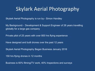
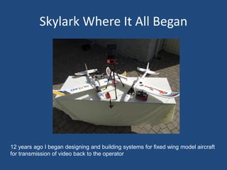
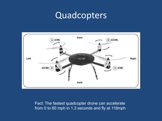
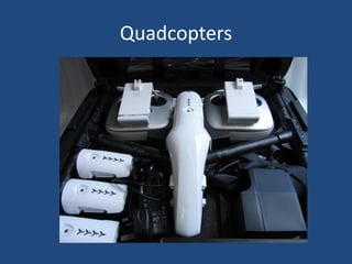
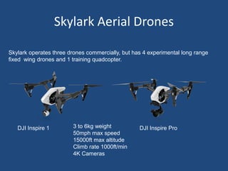
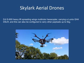
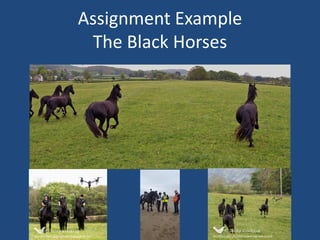
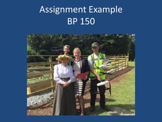
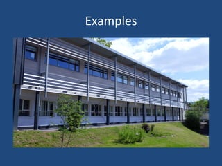
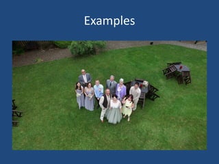
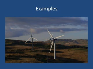
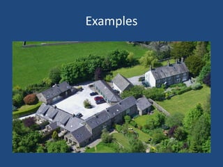
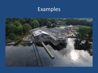
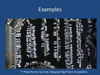
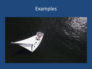
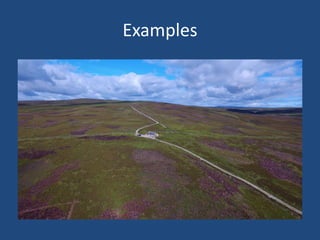
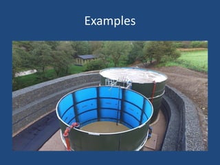
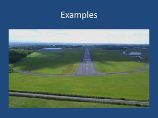
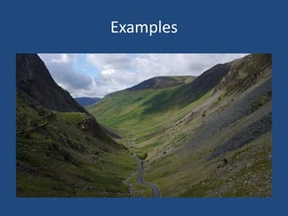
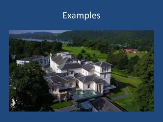
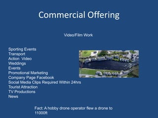
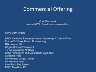
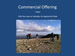
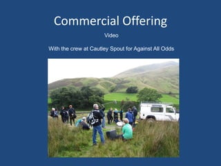
SlideShare a Scribd company logo
Using Drones For Aerial Imagery
Version v2
Simon Handley
Skylark Aerial Photography
www.skylark-aerialphotography.co.uk
Skylark Aerial Photography
Skylark Aerial Photography is run by:- Simon Handley
My Background:- Development & Support Engineer of 28 years travelling
globally for a large gas company
Private pilot of 25 years with over 800 hrs flying experience
Have designed and built drones over the past 12 years
Skylark Aerial Photography Began Business January 2016
150 hrs flying drones in 12 months
Business is 60% filming/TV work, 40% Inspections and surveys
What Is A Drone ?
Drones are more formally known as unmanned aerial vehicles
(UAV). Essentially, a drone is a flying robot. The aircraft may be remotely
controlled or can fly autonomously through software-controlled flight plans in
their systems working in conjunction with GPS.
UAVs have most often been associated with the military but they are also used
for search and rescue, surveillance, traffic monitoring, weather monitoring and
fire fighting, among other things.
Fact:- Drones are named after the male bee
History Of The Drone
The earliest recorded use of an unmanned aerial vehicle for fighting occurred
on August 22, 1849, when the Austrians attacked the Italian city of Venice with
unmanned balloons loaded with explosives.
The first pilotless aircraft were built during and shortly after World War I.
The first large-scale production purpose built drone was the product of
Reginald Denny Hobby Shops Hollywood. He said low cost RC aircraft would
be very useful for training anti-aircraft gunners. Nearly fifteen thousand drones
made for the US army during World War II to practice against.
The first operational decoy drone was the McDonnell Douglas Quail, which was
carried by Boeing B52 bombers to help them penetrate defended airspace in
the 50’s.
History Of The Drone
In May 2006, the (FAA) issued a certificate of authorization which will allow the
Reaper aircraft to be used within U.S. civilian airspace to search for survivors
of disasters.
Use of quadcopters and hexcopters from 2010 for aerial photography
Since 2013 small quadcopters are now readily available for use at home.
Licence regulations began 2013 for commercial operation.
UK there are three classifications for drone use regulated by CAA
0 to 7kg, 7 to 20kg, 20 to 150kg
European Aviation Safety Agency (EASA) governing body regulates drone use
above 150kg in European airspace
Skylark Where It All Began
12 years ago I began designing and building systems for fixed wing model aircraft
for transmission of video back to the operator
Skylark Where It All Began
• Video transmitted to goggles which enabled the operator to fly and control the
plane from FPV (first person view). The planes have full GPS, compass,
altimeter, solid state gyroscope, autopilot.
• TX and RX range 2.5 miles, video down link 15-20 miles.
• Programme the autopilot via PC using waypoints
• Small micro processor controls the plane when required and monitors all
systems including autopilot, batteries, altimeter, gyroscope. Will initiate return
to home if any system is compromised.
• No regulations 12 years ago
Skylark Where It All Began
Regulations & Licence For SUAS
Anyone flying a drone either recreationally or commercially has to take
responsibility for doing so safely. Permission to operate a SUAS (small
unmanned aerial system) for aerial work is required from the CAA (civil
aviation authority).
Theory
Air Law
Theory of Flight
Meteorology
Civil Aviation Procedures (CAPS)
Navigation
Lithium Polymer Batteries
Emergency Procedures
Human Factors
Flight Planning Exercise, and
Operations Manual Guidance
Regulations & Licence For SUAS
Ops Manual
After successful completion of the RPCT (remote pilot certificate course test),
candidates have to complete and submit their Ops Manual for approval. This is
completed in the candidate’s own time and requires them to produce a manual
detailing the way in which they operate their SUAS to conform to regulations and
safety standards.
Operational Evaluation (Flight Test)
Once the Ops Manual is deemed and ratified satisfactory, you will be assigned
an evaluator. The evaluator will give you a practical scenario that reflects a
normal task that you can expect from a customer in the future. You will plan the
mission and carry out the practical task at one of the approved operational sites.
Successful completion of the practical task gives students the RPC (remote pilot
certificate) award and ability to apply for PfCO (permission for commercial
operation) from the CAA.
Operational Requirements
The aircraft must not be flown:
• over or within 150 metres of any congested area
over or within 150 metres of an organised open-air assembly of more than
1,000 persons
• within 50 metres of any vessel, vehicle or structure which is not under the
control of the person in charge of the aircraft
• within 50 metres of any person except during take-off or landing, the aircraft
must not be flown within 30 metres of any person except for the person in
charge of the aircraft.
Fact: The Chinese EHang 184 can
carry 1 person.
Cumbria Air Users Group
Skylark is a member and represents commercial drone users
Meet every 6 months at Police HQ Penrith (Central Point)
Members:-
RAF Control
RAF Spadeadam
CAA (Civil Aviation Authority)
Police Drone Squad
Commercial Drones Operators (Skylark Aerial Photography)
Carlisle Airport
Great North Air Ambulance
Aero Modellers Society
Para Gliders Society
Gliding Society
Flight Training Carlisle
Sellafield
Representative of Light Aircraft Users
Quadcopters
A quadcopter, is a helicopter that is lifted and propelled by four rotors.
Quadcopters generally use two pairs of identical fixed pitched propellers; two
clockwise and two counter-clockwise.
These use independent variation of the speed of each rotor to achieve
control.
By changing the speed of each rotor it is possible to specifically generate a
desired total thrust and so control the quadcopter.
Quadcopters
Fact: The fastest quadcopter drone can accelerate
from 0 to 60 mph in 1.3 seconds and fly at 118mph
Quadcopters
Skylark Aerial Drones
Skylark operates three drones commercially, but has 4 experimental long range
fixed wing drones and 1 training quadcopter.
DJI Inspire 1 DJI Inspire Pro3 to 6kg weight
50mph max speed
15000ft max altitude
Climb rate 1000ft/min
4K Cameras
Skylark Aerial Drones
DJI S-900 heavy lift spreading wings multirotor hexacopter, carrying a Lumix GH4
DSLR, and this can also be configured to carry other payloads up to 5kg.
Skylark Aerial Drones
DJI Inspire 1 professional quadcopters,
which carry the professional *Zenmuse X5
micro four thirds DSLR camera system.
Unlike most drones, we can fit different
lenses (including zoom), which gives us
the ability to capture the perfect footage.
We have a variety of lenses and filters –
Olympus M.Zuiko digital ED 12mm
f/2.0, DJI MFT 15mm f/1.7 ASPH
and Olympus M.Zuiko ED 14-42mm f/3.5-
5.6 EZ, Olympus M.Zuiko ED 45mm
*Zenmuse X5 (rebadged Lumix GH4 for DJI)
The Workhorse
Skylark Aerial Drones
Control
Skylark Aerial Drones
Control
Skylark Aerial Drones
Control
Commercial Offering
Photographic around 20% of work commissioned for:-
Photographic Inspection & Survey around 20% of work commissioned for:-
Estate Agents
Historic Buildings
Airports and Services
Sporting Activities
Inspection (roofs chimneys)
Surveys (wild life)
Landscapes
Attractions
Model Railway Societies
Weddings
Events
Assignment Example
The Black Horses
Assignment Example
BP 150
Examples
Examples
Examples
Examples
Examples
Examples
Examples
Examples
Examples
Examples
Examples
Examples
1st Place Runner Up Daily Telegraph Big Picture Competition
Examples
Examples
Examples
Examples
Examples
Examples
Examples
Examples
Commercial Offering
Video/Film Work
Sporting Events
Transport
Action Video
Weddings
Events
Promotional Marketing
Company Page Facebook
Social Media Clips Required Within 24hrs
Tourist Attraction
TV Productions
News
Fact: A hobby drone operator flew a drone to
11000ft
Commercial Offering
Video/Film Work
Around 60% of work commissioned for
Some work to date
BBC4 Swallows & Amazons Inland Waterways Coniston Water
France TV2 Lake District Documentary
ITN News at 10
Wiggle Outdoor Equipment
TV Series Against All Odds
Great North Swim and Great North Swim Run
Lakeland Trails
Windermere Lakes Cruises
Windermere Jetty
Low Wood Bay Promo
BBC1 Breakfast TV
Commercial Offering
Video
With the crew on Helvellyn for Against All Odds
Commercial Offering
Video
With the crew at Cautley Spout for Against All Odds
The Future ?
The Future ?
Or Is The Future Here ?
Rwanda chosen for world's first 'drone-port' to deliver medical
supplies
Thank You For Your Attention

More Related Content

What's hot

Drones: Present & Future
Drones: Present & FutureDrones: Present & Future
Drones: Present & Future
Fresh Digital Group
 
Drone Technology
Drone TechnologyDrone Technology
Drone Technology
Asad Qayyum Babar
 
Drones and their Increasing Number of Applications
Drones and their Increasing Number of ApplicationsDrones and their Increasing Number of Applications
Drones and their Increasing Number of Applications
Jeffrey Funk
 
Drone
DroneDrone
Drones
DronesDrones
Drones
Guada Casuso
 
Drones
DronesDrones
Drones
vsinha12
 
11. Future of Drones
11. Future of Drones11. Future of Drones
11. Future of Drones
Devender Singh Bohra
 
Drone technology
Drone technologyDrone technology
Drone technology
Ehtasham Anwar
 
Drones (UAV)
Drones (UAV)Drones (UAV)
Unmanned aerial vehicle
Unmanned aerial vehicleUnmanned aerial vehicle
Unmanned aerial vehicle
Varun Karthikeyan
 
Drones
DronesDrones
Drones
DronesDrones
UNMANNED AERIAL VEHICLE
UNMANNED AERIAL VEHICLEUNMANNED AERIAL VEHICLE
UNMANNED AERIAL VEHICLE
Thirumal Aero
 
drones future need
drones future needdrones future need
drones future need
Rushikesh Dudhate
 
Firefighting Drones: Drones in the Field
Firefighting Drones: Drones in the FieldFirefighting Drones: Drones in the Field
Firefighting Drones: Drones in the Field
Dronefly
 
UAV: sensors and Remote sensing techniques for the small platform
UAV: sensors and Remote sensing techniques for the small platformUAV: sensors and Remote sensing techniques for the small platform
UAV: sensors and Remote sensing techniques for the small platform
Hawaii Geographic Information Coordinating Council
 
UAV
UAVUAV
unmanned aerial vehicle (UAV)
unmanned aerial vehicle (UAV)unmanned aerial vehicle (UAV)
unmanned aerial vehicle (UAV)
UDIT PATEL
 
3. Types and applications of drones
3. Types and applications of drones3. Types and applications of drones
3. Types and applications of drones
Devender Singh Bohra
 
bca final year project drone presentation
bca final year project drone presentationbca final year project drone presentation
bca final year project drone presentation
pawanrai68
 

What's hot (20)

Drones: Present & Future
Drones: Present & FutureDrones: Present & Future
Drones: Present & Future
 
Drone Technology
Drone TechnologyDrone Technology
Drone Technology
 
Drones and their Increasing Number of Applications
Drones and their Increasing Number of ApplicationsDrones and their Increasing Number of Applications
Drones and their Increasing Number of Applications
 
Drone
DroneDrone
Drone
 
Drones
DronesDrones
Drones
 
Drones
DronesDrones
Drones
 
11. Future of Drones
11. Future of Drones11. Future of Drones
11. Future of Drones
 
Drone technology
Drone technologyDrone technology
Drone technology
 
Drones (UAV)
Drones (UAV)Drones (UAV)
Drones (UAV)
 
Unmanned aerial vehicle
Unmanned aerial vehicleUnmanned aerial vehicle
Unmanned aerial vehicle
 
Drones
DronesDrones
Drones
 
Drones
DronesDrones
Drones
 
UNMANNED AERIAL VEHICLE
UNMANNED AERIAL VEHICLEUNMANNED AERIAL VEHICLE
UNMANNED AERIAL VEHICLE
 
drones future need
drones future needdrones future need
drones future need
 
Firefighting Drones: Drones in the Field
Firefighting Drones: Drones in the FieldFirefighting Drones: Drones in the Field
Firefighting Drones: Drones in the Field
 
UAV: sensors and Remote sensing techniques for the small platform
UAV: sensors and Remote sensing techniques for the small platformUAV: sensors and Remote sensing techniques for the small platform
UAV: sensors and Remote sensing techniques for the small platform
 
UAV
UAVUAV
UAV
 
unmanned aerial vehicle (UAV)
unmanned aerial vehicle (UAV)unmanned aerial vehicle (UAV)
unmanned aerial vehicle (UAV)
 
3. Types and applications of drones
3. Types and applications of drones3. Types and applications of drones
3. Types and applications of drones
 
bca final year project drone presentation
bca final year project drone presentationbca final year project drone presentation
bca final year project drone presentation
 

Viewers also liked

Aerial photos, surveys most popular business uses for drones, industry finds
Aerial photos, surveys most popular business uses for drones, industry findsAerial photos, surveys most popular business uses for drones, industry finds
Aerial photos, surveys most popular business uses for drones, industry finds
raymondaclkjgahrt
 
XCell Aerial Surveys news article
XCell Aerial Surveys news articleXCell Aerial Surveys news article
XCell Aerial Surveys news articleBlayne Jackson
 
History of unmanned aircraft systems
History of unmanned aircraft systemsHistory of unmanned aircraft systems
History of unmanned aircraft systemsweavercf
 
Aerial mapping services
Aerial mapping servicesAerial mapping services
Aerial mapping services
Eaglelens
 
GeoMonday 2015.3 – A practical guide to use drones
GeoMonday 2015.3 – A practical guide to use dronesGeoMonday 2015.3 – A practical guide to use drones
GeoMonday 2015.3 – A practical guide to use drones
Geo Monday
 
Mapping with Unmanned Airborne Systems (UAS)
Mapping with Unmanned Airborne Systems (UAS)Mapping with Unmanned Airborne Systems (UAS)
Mapping with Unmanned Airborne Systems (UAS)
Merrick & Company
 
(2015/09) Drone Imagery Economics
(2015/09) Drone Imagery Economics(2015/09) Drone Imagery Economics
(2015/09) Drone Imagery Economics
Martin Scholl
 
Remote Sensing with a Drone
Remote Sensing with a DroneRemote Sensing with a Drone
Remote Sensing with a Drone
Travis Peterson
 
Photogrammetry
PhotogrammetryPhotogrammetry
UAV MAPPING, LIDAR MAPPING, LAND AND MINING AND ENGINEERING SURVEY - TES
UAV MAPPING, LIDAR MAPPING, LAND AND MINING AND ENGINEERING SURVEY - TESUAV MAPPING, LIDAR MAPPING, LAND AND MINING AND ENGINEERING SURVEY - TES
UAV MAPPING, LIDAR MAPPING, LAND AND MINING AND ENGINEERING SURVEY - TES
Brett Johnson
 
Aerial photography and remote sensing
Aerial photography and remote sensingAerial photography and remote sensing
Aerial photography and remote sensingakshitakohli
 
Digital image classification
Digital image classificationDigital image classification
Digital image classification
Aleemuddin Abbasi
 
Aerial surveying, mine and engineering surveying services australia
Aerial surveying, mine and engineering surveying services australiaAerial surveying, mine and engineering surveying services australia
Aerial surveying, mine and engineering surveying services australia
Arvista Surveying
 
Photogrammetry 101
Photogrammetry 101Photogrammetry 101
BII The Internet Of Everything 2015
BII The Internet Of Everything 2015 BII The Internet Of Everything 2015
BII The Internet Of Everything 2015
BI Intelligence
 
Aerial photography abraham thomas
Aerial photography abraham thomasAerial photography abraham thomas
Aerial photography abraham thomasSumant Diwakar
 
Surveying Innovations in Quarrying
Surveying Innovations in QuarryingSurveying Innovations in Quarrying
Surveying Innovations in Quarrying
Erik Birzulis
 
Principle of aerial photography and types.ppt
Principle of aerial photography and types.pptPrinciple of aerial photography and types.ppt
Principle of aerial photography and types.ppt
srinivas2036
 
Photogrammetry 1.
Photogrammetry 1.Photogrammetry 1.
Photogrammetry 1.
Naveen Kumar
 

Viewers also liked (20)

Aerial photos, surveys most popular business uses for drones, industry finds
Aerial photos, surveys most popular business uses for drones, industry findsAerial photos, surveys most popular business uses for drones, industry finds
Aerial photos, surveys most popular business uses for drones, industry finds
 
XCell Aerial Surveys news article
XCell Aerial Surveys news articleXCell Aerial Surveys news article
XCell Aerial Surveys news article
 
History of unmanned aircraft systems
History of unmanned aircraft systemsHistory of unmanned aircraft systems
History of unmanned aircraft systems
 
Aerial mapping services
Aerial mapping servicesAerial mapping services
Aerial mapping services
 
Photogrammetry
PhotogrammetryPhotogrammetry
Photogrammetry
 
GeoMonday 2015.3 – A practical guide to use drones
GeoMonday 2015.3 – A practical guide to use dronesGeoMonday 2015.3 – A practical guide to use drones
GeoMonday 2015.3 – A practical guide to use drones
 
Mapping with Unmanned Airborne Systems (UAS)
Mapping with Unmanned Airborne Systems (UAS)Mapping with Unmanned Airborne Systems (UAS)
Mapping with Unmanned Airborne Systems (UAS)
 
(2015/09) Drone Imagery Economics
(2015/09) Drone Imagery Economics(2015/09) Drone Imagery Economics
(2015/09) Drone Imagery Economics
 
Remote Sensing with a Drone
Remote Sensing with a DroneRemote Sensing with a Drone
Remote Sensing with a Drone
 
Photogrammetry
PhotogrammetryPhotogrammetry
Photogrammetry
 
UAV MAPPING, LIDAR MAPPING, LAND AND MINING AND ENGINEERING SURVEY - TES
UAV MAPPING, LIDAR MAPPING, LAND AND MINING AND ENGINEERING SURVEY - TESUAV MAPPING, LIDAR MAPPING, LAND AND MINING AND ENGINEERING SURVEY - TES
UAV MAPPING, LIDAR MAPPING, LAND AND MINING AND ENGINEERING SURVEY - TES
 
Aerial photography and remote sensing
Aerial photography and remote sensingAerial photography and remote sensing
Aerial photography and remote sensing
 
Digital image classification
Digital image classificationDigital image classification
Digital image classification
 
Aerial surveying, mine and engineering surveying services australia
Aerial surveying, mine and engineering surveying services australiaAerial surveying, mine and engineering surveying services australia
Aerial surveying, mine and engineering surveying services australia
 
Photogrammetry 101
Photogrammetry 101Photogrammetry 101
Photogrammetry 101
 
BII The Internet Of Everything 2015
BII The Internet Of Everything 2015 BII The Internet Of Everything 2015
BII The Internet Of Everything 2015
 
Aerial photography abraham thomas
Aerial photography abraham thomasAerial photography abraham thomas
Aerial photography abraham thomas
 
Surveying Innovations in Quarrying
Surveying Innovations in QuarryingSurveying Innovations in Quarrying
Surveying Innovations in Quarrying
 
Principle of aerial photography and types.ppt
Principle of aerial photography and types.pptPrinciple of aerial photography and types.ppt
Principle of aerial photography and types.ppt
 
Photogrammetry 1.
Photogrammetry 1.Photogrammetry 1.
Photogrammetry 1.
 

Similar to Using Drones For Aerial Imagery

Drone technology,UAV
Drone technology,UAVDrone technology,UAV
Drone technology,UAV
Umesh Dadde
 
drone technology
drone technologydrone technology
drone technology
Umesh Dadde
 
Aircraft drone tech.
Aircraft drone tech.Aircraft drone tech.
Aircraft drone tech.
sudarshanbhambhar
 
Neshep 01 12 2015
Neshep 01 12 2015Neshep 01 12 2015
Neshep 01 12 2015
Alan Bassett
 
G012624347
G012624347G012624347
G012624347
IOSR Journals
 
G012624347
G012624347G012624347
G012624347
IOSR Journals
 
Auto Pilot Controlled Flying Wing (UAV) For QRF (Quick Reaction Armed Forces)
Auto Pilot Controlled Flying Wing (UAV) For QRF (Quick Reaction Armed Forces)Auto Pilot Controlled Flying Wing (UAV) For QRF (Quick Reaction Armed Forces)
Auto Pilot Controlled Flying Wing (UAV) For QRF (Quick Reaction Armed Forces)
iosrjce
 
Unmanned Aerial Systems and its history
Unmanned Aerial Systems and its historyUnmanned Aerial Systems and its history
Unmanned Aerial Systems and its history
Amr Emad
 
Quadcopter 140410021020-phpapp02
Quadcopter 140410021020-phpapp02Quadcopter 140410021020-phpapp02
Quadcopter 140410021020-phpapp02
Prasanth Reddy
 
Rcapa proposal2
Rcapa proposal2Rcapa proposal2
Rcapa proposal2
sUAS News
 
SMART Seminar Series: "Potential use of drones for infrastructure inspection ...
SMART Seminar Series: "Potential use of drones for infrastructure inspection ...SMART Seminar Series: "Potential use of drones for infrastructure inspection ...
SMART Seminar Series: "Potential use of drones for infrastructure inspection ...
SMART Infrastructure Facility
 
Quad copter
Quad copterQuad copter
Quad copter
003030
 
Introduction to Drone Tech
Introduction to Drone TechIntroduction to Drone Tech
Introduction to Drone Tech
Anuj Magazine
 
Demystifying Drones | Jillian Switzer | Lunch & Learn
Demystifying Drones | Jillian Switzer | Lunch & LearnDemystifying Drones | Jillian Switzer | Lunch & Learn
Demystifying Drones | Jillian Switzer | Lunch & Learn
UCICove
 
DRONE PPT .1234.pptx
DRONE PPT .1234.pptxDRONE PPT .1234.pptx
DRONE PPT .1234.pptx
AbhishekChauhan510107
 
DRONE.pptx
DRONE.pptxDRONE.pptx
DRONE.pptx
Derricklow6
 
Overview Of Unmanned Aircraft Systems (UAS)
Overview Of Unmanned Aircraft Systems (UAS)Overview Of Unmanned Aircraft Systems (UAS)
Overview Of Unmanned Aircraft Systems (UAS)
Mark Lewellen
 
1. Introduction to drones
1. Introduction to drones1. Introduction to drones
1. Introduction to drones
Devender Singh Bohra
 
4.1. CLASS.pptx
4.1. CLASS.pptx4.1. CLASS.pptx
4.1. CLASS.pptx
NilamadhabMishra7
 
Drones
Drones Drones
Drones
komal jain
 

Similar to Using Drones For Aerial Imagery (20)

Drone technology,UAV
Drone technology,UAVDrone technology,UAV
Drone technology,UAV
 
drone technology
drone technologydrone technology
drone technology
 
Aircraft drone tech.
Aircraft drone tech.Aircraft drone tech.
Aircraft drone tech.
 
Neshep 01 12 2015
Neshep 01 12 2015Neshep 01 12 2015
Neshep 01 12 2015
 
G012624347
G012624347G012624347
G012624347
 
G012624347
G012624347G012624347
G012624347
 
Auto Pilot Controlled Flying Wing (UAV) For QRF (Quick Reaction Armed Forces)
Auto Pilot Controlled Flying Wing (UAV) For QRF (Quick Reaction Armed Forces)Auto Pilot Controlled Flying Wing (UAV) For QRF (Quick Reaction Armed Forces)
Auto Pilot Controlled Flying Wing (UAV) For QRF (Quick Reaction Armed Forces)
 
Unmanned Aerial Systems and its history
Unmanned Aerial Systems and its historyUnmanned Aerial Systems and its history
Unmanned Aerial Systems and its history
 
Quadcopter 140410021020-phpapp02
Quadcopter 140410021020-phpapp02Quadcopter 140410021020-phpapp02
Quadcopter 140410021020-phpapp02
 
Rcapa proposal2
Rcapa proposal2Rcapa proposal2
Rcapa proposal2
 
SMART Seminar Series: "Potential use of drones for infrastructure inspection ...
SMART Seminar Series: "Potential use of drones for infrastructure inspection ...SMART Seminar Series: "Potential use of drones for infrastructure inspection ...
SMART Seminar Series: "Potential use of drones for infrastructure inspection ...
 
Quad copter
Quad copterQuad copter
Quad copter
 
Introduction to Drone Tech
Introduction to Drone TechIntroduction to Drone Tech
Introduction to Drone Tech
 
Demystifying Drones | Jillian Switzer | Lunch & Learn
Demystifying Drones | Jillian Switzer | Lunch & LearnDemystifying Drones | Jillian Switzer | Lunch & Learn
Demystifying Drones | Jillian Switzer | Lunch & Learn
 
DRONE PPT .1234.pptx
DRONE PPT .1234.pptxDRONE PPT .1234.pptx
DRONE PPT .1234.pptx
 
DRONE.pptx
DRONE.pptxDRONE.pptx
DRONE.pptx
 
Overview Of Unmanned Aircraft Systems (UAS)
Overview Of Unmanned Aircraft Systems (UAS)Overview Of Unmanned Aircraft Systems (UAS)
Overview Of Unmanned Aircraft Systems (UAS)
 
1. Introduction to drones
1. Introduction to drones1. Introduction to drones
1. Introduction to drones
 
4.1. CLASS.pptx
4.1. CLASS.pptx4.1. CLASS.pptx
4.1. CLASS.pptx
 
Drones
Drones Drones
Drones
 

Using Drones For Aerial Imagery

  • 1. Using Drones For Aerial Imagery Version v2 Simon Handley Skylark Aerial Photography www.skylark-aerialphotography.co.uk
  • 2. Skylark Aerial Photography Skylark Aerial Photography is run by:- Simon Handley My Background:- Development & Support Engineer of 28 years travelling globally for a large gas company Private pilot of 25 years with over 800 hrs flying experience Have designed and built drones over the past 12 years Skylark Aerial Photography Began Business January 2016 150 hrs flying drones in 12 months Business is 60% filming/TV work, 40% Inspections and surveys
  • 3. What Is A Drone ? Drones are more formally known as unmanned aerial vehicles (UAV). Essentially, a drone is a flying robot. The aircraft may be remotely controlled or can fly autonomously through software-controlled flight plans in their systems working in conjunction with GPS. UAVs have most often been associated with the military but they are also used for search and rescue, surveillance, traffic monitoring, weather monitoring and fire fighting, among other things. Fact:- Drones are named after the male bee
  • 4. History Of The Drone The earliest recorded use of an unmanned aerial vehicle for fighting occurred on August 22, 1849, when the Austrians attacked the Italian city of Venice with unmanned balloons loaded with explosives. The first pilotless aircraft were built during and shortly after World War I. The first large-scale production purpose built drone was the product of Reginald Denny Hobby Shops Hollywood. He said low cost RC aircraft would be very useful for training anti-aircraft gunners. Nearly fifteen thousand drones made for the US army during World War II to practice against. The first operational decoy drone was the McDonnell Douglas Quail, which was carried by Boeing B52 bombers to help them penetrate defended airspace in the 50’s.
  • 5. History Of The Drone In May 2006, the (FAA) issued a certificate of authorization which will allow the Reaper aircraft to be used within U.S. civilian airspace to search for survivors of disasters. Use of quadcopters and hexcopters from 2010 for aerial photography Since 2013 small quadcopters are now readily available for use at home. Licence regulations began 2013 for commercial operation. UK there are three classifications for drone use regulated by CAA 0 to 7kg, 7 to 20kg, 20 to 150kg European Aviation Safety Agency (EASA) governing body regulates drone use above 150kg in European airspace
  • 6. Skylark Where It All Began 12 years ago I began designing and building systems for fixed wing model aircraft for transmission of video back to the operator
  • 7. Skylark Where It All Began • Video transmitted to goggles which enabled the operator to fly and control the plane from FPV (first person view). The planes have full GPS, compass, altimeter, solid state gyroscope, autopilot. • TX and RX range 2.5 miles, video down link 15-20 miles. • Programme the autopilot via PC using waypoints • Small micro processor controls the plane when required and monitors all systems including autopilot, batteries, altimeter, gyroscope. Will initiate return to home if any system is compromised. • No regulations 12 years ago
  • 8. Skylark Where It All Began
  • 9. Regulations & Licence For SUAS Anyone flying a drone either recreationally or commercially has to take responsibility for doing so safely. Permission to operate a SUAS (small unmanned aerial system) for aerial work is required from the CAA (civil aviation authority). Theory Air Law Theory of Flight Meteorology Civil Aviation Procedures (CAPS) Navigation Lithium Polymer Batteries Emergency Procedures Human Factors Flight Planning Exercise, and Operations Manual Guidance
  • 10. Regulations & Licence For SUAS Ops Manual After successful completion of the RPCT (remote pilot certificate course test), candidates have to complete and submit their Ops Manual for approval. This is completed in the candidate’s own time and requires them to produce a manual detailing the way in which they operate their SUAS to conform to regulations and safety standards. Operational Evaluation (Flight Test) Once the Ops Manual is deemed and ratified satisfactory, you will be assigned an evaluator. The evaluator will give you a practical scenario that reflects a normal task that you can expect from a customer in the future. You will plan the mission and carry out the practical task at one of the approved operational sites. Successful completion of the practical task gives students the RPC (remote pilot certificate) award and ability to apply for PfCO (permission for commercial operation) from the CAA.
  • 11. Operational Requirements The aircraft must not be flown: • over or within 150 metres of any congested area over or within 150 metres of an organised open-air assembly of more than 1,000 persons • within 50 metres of any vessel, vehicle or structure which is not under the control of the person in charge of the aircraft • within 50 metres of any person except during take-off or landing, the aircraft must not be flown within 30 metres of any person except for the person in charge of the aircraft. Fact: The Chinese EHang 184 can carry 1 person.
  • 12. Cumbria Air Users Group Skylark is a member and represents commercial drone users Meet every 6 months at Police HQ Penrith (Central Point) Members:- RAF Control RAF Spadeadam CAA (Civil Aviation Authority) Police Drone Squad Commercial Drones Operators (Skylark Aerial Photography) Carlisle Airport Great North Air Ambulance Aero Modellers Society Para Gliders Society Gliding Society Flight Training Carlisle Sellafield Representative of Light Aircraft Users
  • 13. Quadcopters A quadcopter, is a helicopter that is lifted and propelled by four rotors. Quadcopters generally use two pairs of identical fixed pitched propellers; two clockwise and two counter-clockwise. These use independent variation of the speed of each rotor to achieve control. By changing the speed of each rotor it is possible to specifically generate a desired total thrust and so control the quadcopter.
  • 14. Quadcopters Fact: The fastest quadcopter drone can accelerate from 0 to 60 mph in 1.3 seconds and fly at 118mph
  • 16. Skylark Aerial Drones Skylark operates three drones commercially, but has 4 experimental long range fixed wing drones and 1 training quadcopter. DJI Inspire 1 DJI Inspire Pro3 to 6kg weight 50mph max speed 15000ft max altitude Climb rate 1000ft/min 4K Cameras
  • 17. Skylark Aerial Drones DJI S-900 heavy lift spreading wings multirotor hexacopter, carrying a Lumix GH4 DSLR, and this can also be configured to carry other payloads up to 5kg.
  • 18. Skylark Aerial Drones DJI Inspire 1 professional quadcopters, which carry the professional *Zenmuse X5 micro four thirds DSLR camera system. Unlike most drones, we can fit different lenses (including zoom), which gives us the ability to capture the perfect footage. We have a variety of lenses and filters – Olympus M.Zuiko digital ED 12mm f/2.0, DJI MFT 15mm f/1.7 ASPH and Olympus M.Zuiko ED 14-42mm f/3.5- 5.6 EZ, Olympus M.Zuiko ED 45mm *Zenmuse X5 (rebadged Lumix GH4 for DJI) The Workhorse
  • 22. Commercial Offering Photographic around 20% of work commissioned for:- Photographic Inspection & Survey around 20% of work commissioned for:- Estate Agents Historic Buildings Airports and Services Sporting Activities Inspection (roofs chimneys) Surveys (wild life) Landscapes Attractions Model Railway Societies Weddings Events
  • 36. Examples 1st Place Runner Up Daily Telegraph Big Picture Competition
  • 45. Commercial Offering Video/Film Work Sporting Events Transport Action Video Weddings Events Promotional Marketing Company Page Facebook Social Media Clips Required Within 24hrs Tourist Attraction TV Productions News Fact: A hobby drone operator flew a drone to 11000ft
  • 46. Commercial Offering Video/Film Work Around 60% of work commissioned for Some work to date BBC4 Swallows & Amazons Inland Waterways Coniston Water France TV2 Lake District Documentary ITN News at 10 Wiggle Outdoor Equipment TV Series Against All Odds Great North Swim and Great North Swim Run Lakeland Trails Windermere Lakes Cruises Windermere Jetty Low Wood Bay Promo BBC1 Breakfast TV
  • 47. Commercial Offering Video With the crew on Helvellyn for Against All Odds
  • 48. Commercial Offering Video With the crew at Cautley Spout for Against All Odds
  • 51. Or Is The Future Here ? Rwanda chosen for world's first 'drone-port' to deliver medical supplies
  • 52. Thank You For Your Attention