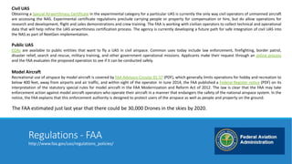
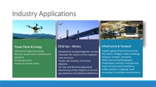
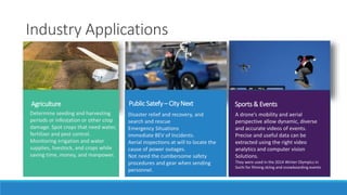
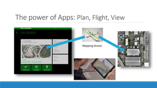
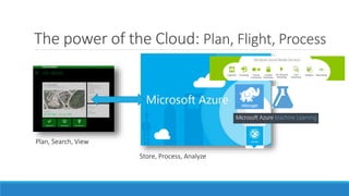
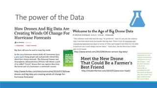
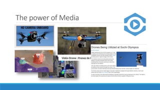
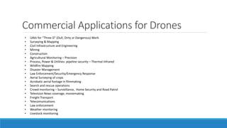
The document discusses various applications and trends related to drones and unmanned aerial vehicles (UAVs). It covers current FAA regulations for different types of drone use, as well as trends showing increasing civilian, commercial, and public sector applications. These include infrastructure inspection, agriculture, filmmaking, emergency response, and more. The document also examines technologies like sensors, cloud computing and big data that are enhancing drone capabilities and potential uses.
Drones are a different kind of new technology from what we’re used to. They offer something else: the conquest of physical space, the extension of society’s compass, the ability to be anywhere and see anything.
For the past few years, one of the most exciting class of gadgets on display has been drones. They got cheaper, lighter, and easier to use even as they became more powerful.
We believe 2015 is an important year for drones as they will change how brands interact with consumers in both advertising and events, and here's everything you need to know about the drone technology.
Drones used in every field , in order to get suitable drone for suitable business, it is essential to check before buying. You must have knowledge about drones,its types and its features. In this presentation we have discussed basic things about drone, its features, advantages,disadvantages and types of drones. Also check our website to know more about best drone advisor and drones.
The given slides provide the information on the evolution of UAV in the USA and its scope in the coming time. The slides previews about the drone startups and famous drones build in the USA.
An unmanned aerial vehicle (UAV), commonly known as a Drone, is an aircraft without a human pilot on board. UAVs can be remote controlled aircraft (e.g. flown by a pilot at a ground control station) or can fly autonomously based on pre-programmed flight plans or more complex dynamic automation systems
A UAV is defined as being capable of controlled, sustained level flight and powered by a jet or reciprocating engine. In addition, a cruise missile can be considered to be a UAV, but is treated separately on the basis that the vehicle is the weapon.
Unmanned Aerial Vehicles (UAVs) are aircrafts that fly without any humans being onboard. They are either remotely piloted, or piloted by an onboard computer. This kind of aircrafts can be used in different military missions such as surveillance, reconnaissance, battle damage assessment, communications relay, minesweeping, hazardous substances detection and radar jamming. However they can be used in other than military missions like detection of hazardous objects on train rails and investigation of infected areas. Aircrafts that are able of hovering and vertical flying can also be used for indoor missions like counter terrorist operations
To download this ppt click on this link
https://adf.ly/PdL4V
In past couple years, drones have been receiving a lot of attention. This presentation provides background, history, and applications of drones from multiple sources.
This presentation gives several examples of how commercial drones are used in industry. Originally presented at the Day of Drones, Hiller Museum of Aviation, San Carlos, California, August 27, 2016
Police and Law Enforcement Drones: Drones In The FieldDronefly
The application of drones equipped with optical, zoom, and/or thermal cameras allow law enforcement to be more effective. Drone technology allows officials to have a better vantage point in situations where sending ground personnel in blind is too risky. This technology also allows accident or crime scenes to be better evaluated to help understand the timeline of events that occurred.
La revolución de los drones. Esta presentación es parte de un gran evento realizado por el GDG Cali donde se hablo de drones y se expuso como programar drones para que realicen cosas autónomas con Node.js
Drone Insights 2021, and its Impact on other sectors in IndiaKaushik Biswas
The Booming Drone Industry and its prospect by 2025. What are the sectors in which Drones can be used in India, the regulatory frameworks comparing World Vs India, What are the Top 3 companies we can do business with, who are the other players in the industry?
I have also done a small survey on what Indians think about the drone industry overall, and finally a conclusion on where we are vs the world
The slides give the brief description of the top most famous drones presently available in the market. These Drones are highly efficient and User-Friendly, that's why it is being loved so much.
This presentation is about ISRAELI drones....by taking through from the article
The link is:(http://www.businessinsider.com/israel-the-land-of-drone-startups-2016-3)
Unmanned Aerial Vehicles (UAVs) are aircrafts that fly without any humans being onboard. They are either remotely piloted, or piloted by an onboard computer. This kind of aircrafts can be used in different military missions such as surveillance, reconnaissance, battle damage assessment, communications relay, minesweeping, hazardous substances detection and radar jamming. However they can be used in other than military missions like detection of hazardous objects on train rails and investigation of infected areas. Aircrafts that are able of hovering and vertical flying can also be used for indoor missions like counter terrorist operations.
Power Presentation on UAVs.Basically covering all the informative topics related to UAVs.Starting from different terminology and ending up to future vision and advantages.
It is actually a fully made presentation one can directly use to present it.It contains pictures so by the use of it one can able to understand each and every line in the particular slide.
Lidar is an acronym for light detection and ranging. It is an optical remote sensing technology that can measure the distance to, or other properties of a target by illuminating the target with light, often using pulses from a laser.
Drones and their Increasing Number of ApplicationsJeffrey Funk
These slides use concepts from my (Jeff Funk) course entitled analyzing hi-tech opportunities to analyze how drones are becoming economic feasible for an increasing number of applications as their costs fall. The costs of drones are falling as the costs of various ICs (controllers, GPS) and MEMS sensors rapidly fall, their performance rises (e.g., accuracy of GPS) and as the cost of carbon fibers fall at a somewhat slower pace than do ICs and MEMS. These falling costs are making drones economically feasible for a number of applications such as producing movies, TV reporting, surveillance, and delivery.
This presentation was given to Florida URISA via webinar on February 13, 2014 by Bill Emison, Senior Account Manager for Merrick & Company of Greenwood Village, Colorado. The purpose of this webinar was to provide an objective and practical review of current unmanned airborne mapping capabilities in the United States.
Drones: The Insurance Industry's Next Game-Changer?Cognizant
Drones promise to be the next disruptive technology -- poised to dramatically alter how industry sectors, including property and casualty insurers, conduct business. Drones have the potential to streamline and reduce the cost of insurance-related processes, including claims adjustment, risk-engineering, post-catastrophe claims settlements and weeding out fraudulent agricultural claims.
Aircraft safety systems are a major concern today and the aviation industry is working hard on technologies that will help improve flight safety. Read this Aranca report to know more.
Aircraft Safety Systems: In The Spotlight - An Aranca ReportAranca
Aircraft safety systems are a major concern today and the aviation industry is working hard on technologies that will help improve flight safety. Read this Aranca report to know more.
Aerial Data Management and The Digital EnterpriseAdvisian
Broader industries have seen improved performance across the whole of asset lifecycle with the extensive application of digital technologies and an increase in the integration of information systems. We explain how.
Drone Guardian: Countering the drone threat to commercial airportsNicholas Meadows
L3 Technologies is currently live trailing its pioneering Drone Guardian technology in both commercial and non-commercial settings. Our whitepaper explores the risk factors associated with drones at commercial airports and considers how a flexible and scalable system such as Drone Guardian can be deployed to counter an ever-growing threat from the illegal and hostile use of both commercial and military drones.
With drone sales set to rise more than
80 per cent this year, to approach
US$500 million, Euroasia Industry
explores some of the most prospective
applications across the commercial
and consumer spectrum.
Connector Corner: Automate dynamic content and events by pushing a buttonDianaGray10
Here is something new! In our next Connector Corner webinar, we will demonstrate how you can use a single workflow to:
Create a campaign using Mailchimp with merge tags/fields
Send an interactive Slack channel message (using buttons)
Have the message received by managers and peers along with a test email for review
But there’s more:
In a second workflow supporting the same use case, you’ll see:
Your campaign sent to target colleagues for approval
If the “Approve” button is clicked, a Jira/Zendesk ticket is created for the marketing design team
But—if the “Reject” button is pushed, colleagues will be alerted via Slack message
Join us to learn more about this new, human-in-the-loop capability, brought to you by Integration Service connectors.
And...
Speakers:
Akshay Agnihotri, Product Manager
Charlie Greenberg, Host
Key Trends Shaping the Future of Infrastructure.pdfCheryl Hung
Keynote at DIGIT West Expo, Glasgow on 29 May 2024.
Cheryl Hung, ochery.com
Sr Director, Infrastructure Ecosystem, Arm.
The key trends across hardware, cloud and open-source; exploring how these areas are likely to mature and develop over the short and long-term, and then considering how organisations can position themselves to adapt and thrive.
Epistemic Interaction - tuning interfaces to provide information for AI supportAlan Dix
Paper presented at SYNERGY workshop at AVI 2024, Genoa, Italy. 3rd June 2024
https://alandix.com/academic/papers/synergy2024-epistemic/
As machine learning integrates deeper into human-computer interactions, the concept of epistemic interaction emerges, aiming to refine these interactions to enhance system adaptability. This approach encourages minor, intentional adjustments in user behaviour to enrich the data available for system learning. This paper introduces epistemic interaction within the context of human-system communication, illustrating how deliberate interaction design can improve system understanding and adaptation. Through concrete examples, we demonstrate the potential of epistemic interaction to significantly advance human-computer interaction by leveraging intuitive human communication strategies to inform system design and functionality, offering a novel pathway for enriching user-system engagements.
Kubernetes & AI - Beauty and the Beast !?! @KCD Istanbul 2024Tobias Schneck
As AI technology is pushing into IT I was wondering myself, as an “infrastructure container kubernetes guy”, how get this fancy AI technology get managed from an infrastructure operational view? Is it possible to apply our lovely cloud native principals as well? What benefit’s both technologies could bring to each other?
Let me take this questions and provide you a short journey through existing deployment models and use cases for AI software. On practical examples, we discuss what cloud/on-premise strategy we may need for applying it to our own infrastructure to get it to work from an enterprise perspective. I want to give an overview about infrastructure requirements and technologies, what could be beneficial or limiting your AI use cases in an enterprise environment. An interactive Demo will give you some insides, what approaches I got already working for real.
The Art of the Pitch: WordPress Relationships and SalesLaura Byrne
Clients don’t know what they don’t know. What web solutions are right for them? How does WordPress come into the picture? How do you make sure you understand scope and timeline? What do you do if sometime changes?
All these questions and more will be explored as we talk about matching clients’ needs with what your agency offers without pulling teeth or pulling your hair out. Practical tips, and strategies for successful relationship building that leads to closing the deal.
Smart TV Buyer Insights Survey 2024 by 91mobiles.pdf91mobiles
91mobiles recently conducted a Smart TV Buyer Insights Survey in which we asked over 3,000 respondents about the TV they own, aspects they look at on a new TV, and their TV buying preferences.
Dev Dives: Train smarter, not harder – active learning and UiPath LLMs for do...UiPathCommunity
💥 Speed, accuracy, and scaling – discover the superpowers of GenAI in action with UiPath Document Understanding and Communications Mining™:
See how to accelerate model training and optimize model performance with active learning
Learn about the latest enhancements to out-of-the-box document processing – with little to no training required
Get an exclusive demo of the new family of UiPath LLMs – GenAI models specialized for processing different types of documents and messages
This is a hands-on session specifically designed for automation developers and AI enthusiasts seeking to enhance their knowledge in leveraging the latest intelligent document processing capabilities offered by UiPath.
Speakers:
👨🏫 Andras Palfi, Senior Product Manager, UiPath
👩🏫 Lenka Dulovicova, Product Program Manager, UiPath
Let's dive deeper into the world of ODC! Ricardo Alves (OutSystems) will join us to tell all about the new Data Fabric. After that, Sezen de Bruijn (OutSystems) will get into the details on how to best design a sturdy architecture within ODC.
Transcript: Selling digital books in 2024: Insights from industry leaders - T...BookNet Canada
The publishing industry has been selling digital audiobooks and ebooks for over a decade and has found its groove. What’s changed? What has stayed the same? Where do we go from here? Join a group of leading sales peers from across the industry for a conversation about the lessons learned since the popularization of digital books, best practices, digital book supply chain management, and more.
Link to video recording: https://bnctechforum.ca/sessions/selling-digital-books-in-2024-insights-from-industry-leaders/
Presented by BookNet Canada on May 28, 2024, with support from the Department of Canadian Heritage.
Essentials of Automations: Optimizing FME Workflows with ParametersSafe Software
Are you looking to streamline your workflows and boost your projects’ efficiency? Do you find yourself searching for ways to add flexibility and control over your FME workflows? If so, you’re in the right place.
Join us for an insightful dive into the world of FME parameters, a critical element in optimizing workflow efficiency. This webinar marks the beginning of our three-part “Essentials of Automation” series. This first webinar is designed to equip you with the knowledge and skills to utilize parameters effectively: enhancing the flexibility, maintainability, and user control of your FME projects.
Here’s what you’ll gain:
- Essentials of FME Parameters: Understand the pivotal role of parameters, including Reader/Writer, Transformer, User, and FME Flow categories. Discover how they are the key to unlocking automation and optimization within your workflows.
- Practical Applications in FME Form: Delve into key user parameter types including choice, connections, and file URLs. Allow users to control how a workflow runs, making your workflows more reusable. Learn to import values and deliver the best user experience for your workflows while enhancing accuracy.
- Optimization Strategies in FME Flow: Explore the creation and strategic deployment of parameters in FME Flow, including the use of deployment and geometry parameters, to maximize workflow efficiency.
- Pro Tips for Success: Gain insights on parameterizing connections and leveraging new features like Conditional Visibility for clarity and simplicity.
We’ll wrap up with a glimpse into future webinars, followed by a Q&A session to address your specific questions surrounding this topic.
Don’t miss this opportunity to elevate your FME expertise and drive your projects to new heights of efficiency.
Search and Society: Reimagining Information Access for Radical FuturesBhaskar Mitra
The field of Information retrieval (IR) is currently undergoing a transformative shift, at least partly due to the emerging applications of generative AI to information access. In this talk, we will deliberate on the sociotechnical implications of generative AI for information access. We will argue that there is both a critical necessity and an exciting opportunity for the IR community to re-center our research agendas on societal needs while dismantling the artificial separation between the work on fairness, accountability, transparency, and ethics in IR and the rest of IR research. Instead of adopting a reactionary strategy of trying to mitigate potential social harms from emerging technologies, the community should aim to proactively set the research agenda for the kinds of systems we should build inspired by diverse explicitly stated sociotechnical imaginaries. The sociotechnical imaginaries that underpin the design and development of information access technologies needs to be explicitly articulated, and we need to develop theories of change in context of these diverse perspectives. Our guiding future imaginaries must be informed by other academic fields, such as democratic theory and critical theory, and should be co-developed with social science scholars, legal scholars, civil rights and social justice activists, and artists, among others.
5. Civil UAS
Obtaining a Special Airworthiness Certificate in the experimental category for a particular UAS is currently the only way civil operators of unmanned aircraft
are accessing the NAS. Experimental certificate regulations preclude carrying people or property for compensation or hire, but do allow operations for
research and development, flight and sales demonstrations and crew training. The FAA is working with civilian operators to collect technical and operational
data that will help refine the UAS airworthiness certification process. The agency is currently developing a future path for safe integration of civil UAS into
the NAS as part of NextGen implementation.
Public UAS
COAs are available to public entities that want to fly a UAS in civil airspace. Common uses today include law enforcement, firefighting, border patrol,
disaster relief, search and rescue, military training, and other government operational missions. Applicants make their request through an online process
and the FAA evaluates the proposed operation to see if it can be conducted safely.
Model Aircraft
Recreational use of airspace by model aircraft is covered by FAA Advisory Circular 91-57 (PDF), which generally limits operations for hobby and recreation to
below 400 feet, away from airports and air traffic, and within sight of the operator. In June 2014, the FAA published a Federal Register notice (PDF) on its
interpretation of the statutory special rules for model aircraft in the FAA Modernization and Reform Act of 2012. The law is clear that the FAA may take
enforcement action against model aircraft operators who operate their aircraft in a manner that endangers the safety of the national airspace system. In the
notice, the FAA explains that this enforcement authority is designed to protect users of the airspace as well as people and property on the ground.
The FAA estimated just last year that there could be 30,000 Drones in the skies by 2020.
Regulations - FAA
http://www.faa.gov/uas/regulations_policies/
6. Industry Applications
Power Plants & Energy Oil & Gas –Minery
Advanced Image processing
Monitor power lines, turbines and
pipelines.
Surveying assets
Access to remote areas
Geophysical and geomagnetic surveys
Calculate the nature of the magnetic
rock structure
Predict the location of mineral
deposits.
Oil, Gas and Mineral exploration
Monitoring of the integrity of oil and
gas pipelines and related installations.
Infrastructure & Transport
Inspect aging infrastructure across
the nation: bridges, roads, buildings,
railways, harbors, and ports.
DEMs and orthophotography
Understand, monitor, and optimize
road and train track conditions,
traffic patterns, mapping. Land
surveying & Landslide measurement
7. Industry Applications
Agriculture Public Satefy – City Next
Determine seeding and harvesting
periods or infestation or other crop
damage. Spot crops that need water,
fertilizer and pest control.
Monitoring irrigation and water
supplies, livestock, and crops while
saving time, money, and manpower.
Disaster relief and recovery, and
search and rescue
Emergency Situations
Immediate BEV of Incidents.
Aerial inspections at will to locate the
cause of power outages.
Not need the cumbersome safety
procedures and gear when sending
personnel.
Sports & Events
A drone’s mobility and aerial
perspective allow dynamic, diverse
and accurate videos of events.
Precise and useful data can be
extracted using the right video
analytics and computer vision
Solutions.
They were used in the 2014 Winter Olympics in
Sochi for filming skiing and snowboarding events.
8. The power of Apps: Plan, Flight, View
Mapping drones
9. The power of the Cloud: Plan, Flight, Process
Plan, Search, View
Store, Process, Analyze
10. The power of the Data
http://www.wired.com/2013/04/drone-sensors-big-data/
http://www.forbes.com/sites/centurylink/2014/07/28/how-drones-
and-big-data-are-creating-winds-of-change-for-hurricane-
forecasts/
http://modernfarmer.com/2014/01/precision-hawk/
13. Arr.drone 2.0 by Parrot
HD Battery
1000 mAh
Navigation
Board
Main Board
VIDEOS
•Low latency streaming
•Video storage on the fly with remote device or with USB flash drive
•JPEG photo capture
•720p - 30FPS - H264 encoding base profile
All parts and
instructions for
repairing available
on the internet
• Wi-Fi connection to the Ground Control System
(App)
•Outdoor and Indoor Hull
1GHz 32 bit ARM Cortex A8 processor with 800MHz
video DSP TMS320DMC64x
Linux 2.6.32
1GB DDR2 RAM at 200MHz
USB 2.0 high speed for extensions
http://ardrone2.parrot.com/
15. Remote Sensing: Current … Futures
UAV remote sensing functions include electromagnetic spectrum sensors,
gamma ray sensors, biological sensors, and chemical sensors.
A UAV's electromagnetic sensors typically include visual spectrum, infrared, or
near infrared cameras as well as radar systems.
Biological sensors are sensors capable of detecting the airborne presence of
various microorganisms and other biological factors.
Chemical sensors use laser spectroscopy to analyze the concentrations of each
element in the air.
Today, sUAS make accurate, high resolution point clouds representing the “surface”
of things.
LiDAR sensors will become common in the next 1-3 years, and will produce high
resolution point clouds of the earth, not only the surface of things.
18. Jerga
Drone or UAV - unmanned aerial vehicle, also unpiloted aerial vehicle
Or UAS - unpiloted air system or RPA - remotely piloted aircraft
FAA - Federal Aviation Administration
BEV- Bird eye view
GCS - Ground Control Station
GDT – Ground Data Terminal
FPV – First Person View
FMV – Full Motion Video
APM Advanced Power Management Support
19. Commercial Applications for Drones
• UAVs for “Three D” (Dull, Dirty or Dangerous) Work
• Surveying & Mapping
• Civil Infrastructure and Engineering
• Mining
• Construction
• Agricultural Monitoring – Precision
• Process, Power & Utilities: pipeline security – Thermal Infrared
• Wildfire Mapping
• Disaster Management
• Law Enforcement/Security/Emergency Response
• Aerial Surveying of crops
• Acrobatic aerial footage in filmmaking
• Search and rescue operations
• Crowd monitoring – Surveillance, Home Security and Road Patrol
• Television News coverage, moviemaking
• Freight Transport
• Telecomunications
• Law enforcement
• Weather monitoring
• Livestock monitoring
20. Links
http://www.forbes.com/sites/forbesleadershipforum/2014/10/10/drones-in-hollywood-what-industry-is-next/
https://www.energyvoice.com/oilandgas/51543/robot-flying-machines-set-make-oil-industry-mark/
http://www.ted.com/talks/sergei_lupashin_a_flying_camera_on_a_leash
http://irjci.blogspot.com/2014/04/energy-industry-using-drones-as.html
http://www.motiondsp.com/Stories/#View Inside the Well
http://www.nytimes.com/2014/04/22/business/energy-environment/drones-are-becoming-energys-new-roustabouts.html?_r=1
http://www.wired.com/2014/11/faas-drone-rules-narrow-theyre-better-nothing/
http://live.huffingtonpost.com/r/segment/drones-drone-technology-dji-innovations/546171692b8c2adc30000001
http://fukushimaupdate.com/drones-to-monitor-radiation-at-crippled-fukushima-plant-in-2015/
https://www.skycatch.com/data.html
http://news.yahoo.com/sochi-drone-shooting-olympic-tv-not-terrorists-152517775.html
http://www.wired.com/2014/07/the-next-big-thing-you-missed-drones-as-a-cloud-service-that-actually-flies/
http://droneanalyst.com/2014/02/14/drones-revolution-means-big-data-cloud-services/
The greater value is in the data captured. Because small drones can fly at low-altitude, they make perfect precision image and data capture vehicles. Right now, it’s more efficient to fly an inexpensive drone over a large land area than it is to traverse it in a vehicle — and even more efficient than sending out an expensive multi-person surveying team. Keep in mind a digital photograph or video is not simply an image or composite of images. Rather, it is the result of processing visual light (blue, green, and red) as a binary numeric representation of a two-dimensional image—in other words, light becomes digital data. As cameras become more resolute, the amount of data captured goes up — as does the potential value of those images. But prices are coming down. For example, what once was available a few years ago only from a high-value satellite image service provider now comes from a drone affixed with a consumer level camera and off-the-shelf PC software. The software can automatically build textured 3D models from still images. And then there’s infrared cameras. They are now small enough, light enough, and cheap enough to mount on a drone. Infrared cameras don’t just let you see differences in heat; they let you measure those differences. So, there’s even more valuable data to evaluate.
Big farms mean big data. Dr. Kevin Price of Kansas State University says that about 80% of the money that will be spent on unmanned aerial vehicles in the next 10 years will be spent in the area of agriculture. He and others predict this will be a $100 billion industry by the year 2025. Agriculture applications for drones currently in development include data collection on crop health, vigor and yields; tracking the spread of invasive plant species; and monitoring cattle feedlots. Field images from cameras mounted on drones can be captured within an inch of accuracy. You can’t get that from a satellite or commercial aircraft image. Small drones are agile enough to provide ‘anywhere, anytime’ remote access. That means farmers and ranchers can do daily surveys to find exactly the right time to harvest or replenish feed stock. Similarly, changes over time can be equally revealing. By doing regular surveys and using software to highlight differences over time, it’s possible to zero in on anomalies. This valuable information, of course, can be used to improve productivity.
Cloud-based services are the future. You can buy a decent image-capture drone off the shelf for about $1200 US, but that doesn’t make you an image information specialist. The first thing you need to realize is that flying a drone and taking pictures is merely the first step in the data collection process. Images need to be corrected, calibrated, processed, stored, and evaluated. For precision agriculture, data quality and post-processing are critical to getting real value from the images. And helping the customer attain that value is the role of a data services provider. Already PrecisionHawk offers a service they call PrecisionMapper, “a cloud-based application that gives anyone the ability to upload, store, process, and share their aerial image data.”
By gathering data on a large scale over time, service providers will be able to process unprecedented levels of detail data and turn it into usable information for farmers. This vision is confirmed in a recent article where PrecisionHawk’s president Ernest Earon says ” the company views itself as a data company, rather than a drone company. He envisions an “app store” model that would allow, say, somebody in North Dakota with a top-notch algorithm for detecting potato blight, to license it to other farmers.”
There you have it. This is the future of small drones and I suspect as their use and applications increase small and medium business (SMB) niche service providers will flourish. And as they flourish these firms will differentiate themselves based on processing speed and the salience of their insights. Certainly the use of a cloud-based in-memory computing platform to accelerate analytics, processes, and predictive capabilities will be foundational to that differentiation.
Feel free to leave a comment telling me about your interest in this innovation.