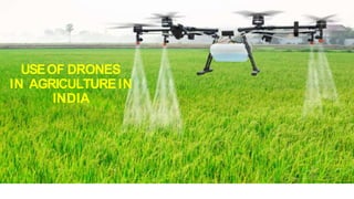
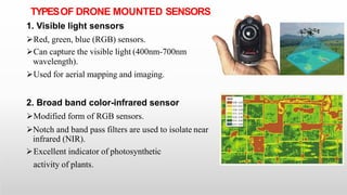
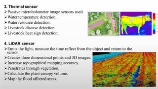
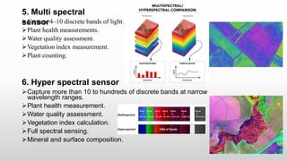
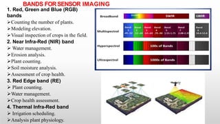
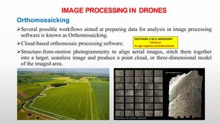
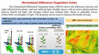
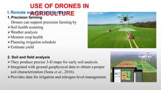
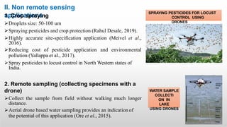
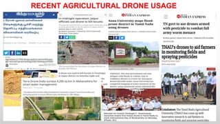
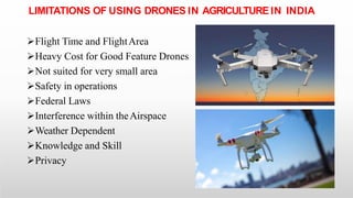
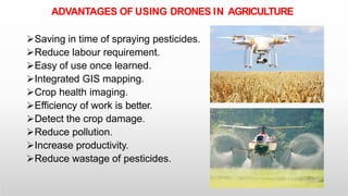
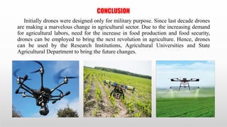
USEOF DRONES
IN AGRICULTUREIN
INDIA
INTRODUCTION
Global food hunger affects 815 million people every year.
FAO projected that current Agricultural production level need to
rise up to 60% by 2050.
IPCC warns that crop yield may decrease by 10 to 25% in the
fact of climate change by 2050.
Farming communities must adopt the various technologies to
increase the yield and food grains production.
One of such a latest modern technology is the use of small,
unmanned aerial vehicles (UAV’s) commonly known as drone.
“In the current milieu, use of sustainable information and
communication technology in agriculture in not an option. It is
a necessity.”
Gerard Sylvester,
FAO
What is drone?
Navigation
Drone is a common name for Unmanned Aerial Vehicles.
Drone stands for Dynamic Remotely Operated
Equipment.
Drone is a remotely piloted aircraft controlled directly by a human
operator via a radio link, or with various levels of autonomy achieved by
using autopilot technology.
HISTORY OF DRONES
In 1849 Austrians used unmanned air balloons.
Reginald Denny manufactured fifteen thousand radio plane
drones for the US Army during World WarII.
French Engineer, Etienne Omnichen invented the first
quadcopter “Omnichen 2” in 1922.
In 1983, remote control aerial spraying system was used to
spray agro chemicals in Japan.
The R-50 was the world’s first unmanned helicopter for
crop dusting capable of carrying a 20 kg payload.
The well-documented potential for drones to revolutionize
agriculture reached its zenith in 2015.
The value of global drone sales reached USD $8.5bn in
2016 and is expected to surpass USD $12bn by 2021.
CLASSIFICATION OF DRONES
I. Based on form, features and functions
1. Fixed wing drone
Have two wing design as like aero plane.
Operate up to the speed of 50km/hr.
Larger field mapping.
Transport heavier loads over long distance.
They cannot takeoff vertically.
2. Single rotor drone
Have only one rotor.
Can takeoff and land vertically.
More efficient than multi rotor drones.
Used for spraying of agrochemicals.
3. Multi rotor drone
Have four rotors or Eight rotors.
Life time only of 10 to 20 minutes.
Take off and land vertically.
Record pictures and transport light cargo.
Mostly used for spraying of agrochemicals.
4. Hybrid drone
Equipped with both wings and rotors.
Can takeoff and land vertically.
Cover far longer distances.
carry heavier cargo than multi-rotor drones.
5. Ducted fan drone
Can take off and land vertically.
Used for crop monitoring.
II. Based on maximum takeoff weight (including
payload)
Civil Remotely Piloted Aircraft is categorized in accordance with
maximum takeoff weight as
1. Nano: Less than or equal to 250 grams.
2. Micro: Greater than 250 grams and less than or equal to 2 kg.
3. Small: Greater than 2 kg and less than or equal to 25 Kg.
4. Medium: Greater than 25 kg and less than or equal to 150 kg.
5. Large: Greater than 150 kg.
COMPONENTS OF A DRONE
1. Sensors
Silicon based sensors are mostly used.
Camera systems
Video systems
Scanners
2. Mechanical tools
Frame
Motors
Electronic speed controller
Battery
Radio receiver
Spraying systems
3. Cargo
Carrying and delivering all kind of
things.
TYPESOF DRONE MOUNTED SENSORS
1. Visible light sensors
Red, green, blue (RGB) sensors.
Can capture the visible light (400nm-700nm
wavelength).
Used for aerial mapping and imaging.
2. Broad band color-infrared sensor
Modified form of RGB sensors.
Notch and band pass filters are used to isolate near
infrared (NIR).
Excellent indicator of photosynthetic
activity of plants.
3. Thermal sensor
Passive microbolometer image sensors used.
Water temperature detection.
Water resource detection.
Livestock disease detection.
Livestock heat sign detection.
4. LiDAR sensor
Emits the light, measure the time reflect from the object and return to the
sensor.
Creates three dimensional points and 3D images.
Increase topographical mapping accuracy.
Penetrates through vegetation.
Calculate the plant canopy volume.
Map the flood affected areas.
5. Multi spectral
sensor
Capture 4–10 discrete bands of light.
Plant health measurements.
Water quality assessment.
Vegetation index measurement.
Plant counting.
6. Hyper spectral sensor
Capture more than 10 to hundreds of discrete bands at narrow
wavelength ranges.
Plant health measurement.
Water quality assessment.
Vegetation index calculation.
Full spectral sensing.
Mineral and surface composition.
BANDS FORSENSOR IMAGING
1. Red, Green and Blue (RGB)
bands
Counting the number of plants.
Modeling elevation.
Visual inspection of crops in the field.
2. Near Infra-Red (NIR) band
 Water management.
Erosion analysis.
Plant counting.
Soil moisture analysis.
Assessment of crop health.
3. Red Edge band (RE)
 Plant counting.
Water management.
Crop health assessment.
4. Thermal Infra-Red band
 Irrigation scheduling.
Analysis plant physiology.
IMAGE PROCESSING IN DRONES
Orthomosaicking
Several possible workflows aimed at preparing data for analysis in image processing
software is known as Orthomosaicking.
Cloud-based orthomosaic processing software.
Structure-from-motion photogrammetry to align aerial images, stitch them together
into a larger, seamless image and produce a point cloud, or three-dimensional model
of the imaged area.
Normalized Difference Vegetation Index
The Normalized Differential Vegetation Index (NDVI) shows the difference between red
light reflected from plants, and near infrared light. Healthy leaves with an active photosynthesis
process absorb red light, and strongly reflect near infrared light. Dead, or unhealthy leaves
reflect both wavelengths of light. This property can be used to measure the health of crops.
NIR - Near Infrared light
The range of NDVI lies between -1 and
+1.
NDVI has been used extensively with remarkable success, for
vegetation
assessment over a wide range of spatial scales and remote sensing
platforms.
(Carlson and Ripley, 1997)
DRONE TECHNOLOGY IN AGRICULTUREIN INDIA
The Drone Federation of India (DFI), supports and attempts to build a safer and scalable unmanned
aviation industry in India.
In India presently, the firms registered in the DIGITAL SKY platform of DGCA (Director General
Civil Aviation, GOI) for manufacture of drones are listed in thetable.
S. No RPA Name Manufacturer Name Max. take-off
weight (kg)
Max. height
attainable (ft)
1 LookOut VTOL RPAS Throttle Aerospace Systems
Private
Limited
1.99 400
2 Patang Skylark Drones Pvt Ltd 1.9 1000
3 A200 Asteria Aerospace Pvt Ltd 1.9 200
4 Insight Aarav Unmanned Systems Pvt
Ltd
3.6 400
5 Ninja ideaForge Technology Pvt Ltd 1.98 400
6 Agribot UAV (AGUAV) IoTechWorld Avigation Pvt Ltd 23.2 33
7 Prion Mk3 UAVE Limited 42.88 12100
8 Starlite Hubblefly Technologies Pvt Ltd 1.92 9842
9 Freebird Z1 A Ecom Infotech India Limited 4 13123
10 DH-Q4 Dhasksha Unmanned Systems
Pvt
Ltd
5.18 400
11 WHITE HAWK EDALL SYSTEMS 1.98 11482
12 Staredge Hubblefly Technologies Pvt
Limited
4.25 400
13 Model V CBAI Technologies Private
Limited
3.33 400
14 A400 Asteria Aerospace Pvt Ltd 3.4 400
15 NOCTUA DS Detect Technologies Pvt Ltd 1.85 2624
USE OF DRONES IN
AGRICULTURE
I. Remote sensing applications
1. Precision farming
Drones can support precision farming by
Soil health scanning
Weather analysis
Monitor crop health
Planning irrigation schedule
Estimate yield
2. Soil and field analysis
They produce precise 3-D maps for early soil analysis.
Integrated with ground geophysical data to obtain a proper
soil characterization (Sona et al., 2016).
Provides data for irrigation and nitrogen-level management.
3. Planting
Seed dispersing software is mounted on quadcopter.
Seeds are precisely released at the desired location (Fortes,
2017).
4. Seedling emergence assessment
Seedlings can be viewed.
Identify unsuccessful germination (Sankaran et al., 2015).
5. Weed mapping
Weed mapping by drones is commonly used in agriculture
(Thorp and Tian, 2004).
Identify greater weed density using vectorized weed and
crop cover maps.
6. Crop health
assessment
Disease surveillance
FAO designed the dLocust drones to monitor the locust infestation.
7. Crop damage assessment & Crop
insurance
Flood assessment in Cuddalore district in 2015 (Gille,
Pazhanivelan and Yadav, 2016).
Location and quantification of crop damage (Puri et al., 2017).
Drought assessment in 2016 in Tamil Nadu.
2,00,000 farmers got insurance claims.
Monitor the flood affected field in Beed district of Maharashtra.
In 2014, Skymet, AIC and the Gujarat government implemented
drones across 10 villages in Morbi district of Gujarat to detect
flood affected areas.
DROUGHT ASSESSMENT
DURING 2016 IN CAUVERY
DELTA ZONE
PEST AFFECTED TEA BUSHES
IN
ASSAM
8. Land use
survey
Exact area measurements of land utilization.
9. Water management
Drones with hyper spectral, multispectral, or thermal
sensors can identify which parts of a field are dry or
need improvements.
NDVI, Crop-Water Stress Index (CWSI) and the
Canopy-Chlorophyll Content Index (CCCI) can be
used.
When the plant becomes dehydrated or stressed, the
leaves reflect less NIR light, but the same amount in
the visible range. This is used to detect water stress.
LAND SURVEY BY TERRA DRONE INDIA IN
MAHARASTRA
WATER STRESS DETECTION IN WHEAT
10. Forestry and Wildlife
conservation
 Carbon sequestration.
 Tree canopy analysis.
 Track native species.
 Monitoring biodiversity.
 Ecological landscape features.
 Detect poachers in Kaziranga National
Park.
 Forest department used drone over Sirumugai
and
Mettupalayam forest ranges to find the sick wild
elephant in that area.
temperature - infectious diseases in
11.
Livestock
 Elevated
body
livestock.
 Measurement of body
temperature.
 Screening of livestock for the possible presence of
infections (Gloster et al.,
2011).
 Locate inflammatory lesions (McManus et al.,
2016).
 Detect heat in livestock.
 Counting the livestock.
WILD ANIMAL SURVEY AT KAZIRANGA
NATIONAL PARK, SIRUMUGAI AND
METTUPALAYAM FOREST RANGES
DETECTION OF BODY TEMPERATURE IN CATTLE
AND
COUNTING NUMBER OF CATTLE IN A FIELD
II. Non remote sensing
applications
1. Crop spraying
Droplets size: 50-100 um
Spraying pesticides and crop protection (Rahul Desale, 2019).
Highly accurate site-specification application (Meivel et al.,
2016).
Reducing cost of pesticide application and environmental
pollution (Yallappa et al., 2017).
Spray pesticides to locust control in North Western states of
India.
2. Remote sampling (collecting specimens with a
drone)
Collect the sample from field without walking much longer
distance.
Aerial drone based water sampling provides an indication of
the potential of this application (Ore et al., 2015).
SPRAYING PESTICIDES FOR LOCUST
CONTROL USING
DRONES
WATER SAMPLE
COLLECTI
ON IN
LAKE
USING DRONES
RECENT AGRICULTURAL DRONE USAGE
IN INDIA
LIMITATIONS OF USING DRONES IN AGRICULTURE IN INDIA
Flight Time and FlightArea
Heavy Cost for Good Feature Drones
Not suited for very small area
Safety in operations
Federal Laws
Interference within theAirspace
Weather Dependent
Knowledge and Skill
Privacy
AGRICULTURESOFTWAREPACKAGESFOR AERIAL IMAGING
PIX4D
QGIS
DroneDeploy
PRECISION HAWK
Sentera AgVaultWeb
Botlink
ADVANTAGES OF USING DRONES IN AGRICULTURE
Saving in time of spraying pesticides.
Reduce labour requirement.
Easy of use once learned.
Integrated GIS mapping.
Crop health imaging.
Efficiency of work is better.
Detect the crop damage.
Reduce pollution.
Increase productivity.
Reduce wastage of pesticides.
LEGALISSUES,RULESAND REGULATIONS FOR USING DRONES IN
INDIA
 Directorate General of Civil Aviation - Import clearance , Issuance of UIN , Issuance & renewal of UAOP , Suspension /
Cancellation of UIN & UAOP in case of violations of regulations.
 Directorate General of Foreign Trade - Import license
 Ministry of Home Affairs - Security clearance
over the
 Ministry of Defense - Permission for aerial survey/imageries/ videography/ still photography
restricted/prohibited areas.
 Indian Air Force - Air Defense Clearance, Monitoring of RPAmovements in thecountry
 Wireless Planning and Coordination Wing, Department of Telecommunication - License for drone
 Bureau of Civil Aviation Security -Approval of Security Programme.
 Airport Authority of India - Flight Plan Approval , Monitoring of RPAmovements in thecountry
 Local Police Office -Enforcement of violators as per applicable IPCs
S. No CATEGORY COST (Rs)
1 UIN 1000
2 Fresh UAOP 25,000
3 Renewal of UAOP 10,000
CONCLUSION
Initially drones were designed only for military purpose. Since last decade drones
are making a marvelous change in agricultural sector. Due to the increasing demand
for agricultural labors, need for the increase in food production and food security,
drones can be employed to bring the next revolution in agriculture. Hence, drones
can be used by the Research Institutions, Agricultural Universities and State
Agricultural Department to bring the future changes.
THANK YOU

use of drones.pptx

  • 1.
  • 2.
    INTRODUCTION Global food hungeraffects 815 million people every year. FAO projected that current Agricultural production level need to rise up to 60% by 2050. IPCC warns that crop yield may decrease by 10 to 25% in the fact of climate change by 2050. Farming communities must adopt the various technologies to increase the yield and food grains production. One of such a latest modern technology is the use of small, unmanned aerial vehicles (UAV’s) commonly known as drone. “In the current milieu, use of sustainable information and communication technology in agriculture in not an option. It is a necessity.” Gerard Sylvester, FAO
  • 3.
    What is drone? Navigation Droneis a common name for Unmanned Aerial Vehicles. Drone stands for Dynamic Remotely Operated Equipment. Drone is a remotely piloted aircraft controlled directly by a human operator via a radio link, or with various levels of autonomy achieved by using autopilot technology.
  • 4.
    HISTORY OF DRONES In1849 Austrians used unmanned air balloons. Reginald Denny manufactured fifteen thousand radio plane drones for the US Army during World WarII. French Engineer, Etienne Omnichen invented the first quadcopter “Omnichen 2” in 1922. In 1983, remote control aerial spraying system was used to spray agro chemicals in Japan. The R-50 was the world’s first unmanned helicopter for crop dusting capable of carrying a 20 kg payload. The well-documented potential for drones to revolutionize agriculture reached its zenith in 2015. The value of global drone sales reached USD $8.5bn in 2016 and is expected to surpass USD $12bn by 2021.
  • 5.
    CLASSIFICATION OF DRONES I.Based on form, features and functions 1. Fixed wing drone Have two wing design as like aero plane. Operate up to the speed of 50km/hr. Larger field mapping. Transport heavier loads over long distance. They cannot takeoff vertically. 2. Single rotor drone Have only one rotor. Can takeoff and land vertically. More efficient than multi rotor drones. Used for spraying of agrochemicals.
  • 6.
    3. Multi rotordrone Have four rotors or Eight rotors. Life time only of 10 to 20 minutes. Take off and land vertically. Record pictures and transport light cargo. Mostly used for spraying of agrochemicals. 4. Hybrid drone Equipped with both wings and rotors. Can takeoff and land vertically. Cover far longer distances. carry heavier cargo than multi-rotor drones. 5. Ducted fan drone Can take off and land vertically. Used for crop monitoring.
  • 7.
    II. Based onmaximum takeoff weight (including payload) Civil Remotely Piloted Aircraft is categorized in accordance with maximum takeoff weight as 1. Nano: Less than or equal to 250 grams. 2. Micro: Greater than 250 grams and less than or equal to 2 kg. 3. Small: Greater than 2 kg and less than or equal to 25 Kg. 4. Medium: Greater than 25 kg and less than or equal to 150 kg. 5. Large: Greater than 150 kg.
  • 8.
    COMPONENTS OF ADRONE 1. Sensors Silicon based sensors are mostly used. Camera systems Video systems Scanners 2. Mechanical tools Frame Motors Electronic speed controller Battery Radio receiver Spraying systems 3. Cargo Carrying and delivering all kind of things.
  • 9.
    TYPESOF DRONE MOUNTEDSENSORS 1. Visible light sensors Red, green, blue (RGB) sensors. Can capture the visible light (400nm-700nm wavelength). Used for aerial mapping and imaging. 2. Broad band color-infrared sensor Modified form of RGB sensors. Notch and band pass filters are used to isolate near infrared (NIR). Excellent indicator of photosynthetic activity of plants.
  • 10.
    3. Thermal sensor Passivemicrobolometer image sensors used. Water temperature detection. Water resource detection. Livestock disease detection. Livestock heat sign detection. 4. LiDAR sensor Emits the light, measure the time reflect from the object and return to the sensor. Creates three dimensional points and 3D images. Increase topographical mapping accuracy. Penetrates through vegetation. Calculate the plant canopy volume. Map the flood affected areas.
  • 11.
    5. Multi spectral sensor Capture4–10 discrete bands of light. Plant health measurements. Water quality assessment. Vegetation index measurement. Plant counting. 6. Hyper spectral sensor Capture more than 10 to hundreds of discrete bands at narrow wavelength ranges. Plant health measurement. Water quality assessment. Vegetation index calculation. Full spectral sensing. Mineral and surface composition.
  • 12.
    BANDS FORSENSOR IMAGING 1.Red, Green and Blue (RGB) bands Counting the number of plants. Modeling elevation. Visual inspection of crops in the field. 2. Near Infra-Red (NIR) band  Water management. Erosion analysis. Plant counting. Soil moisture analysis. Assessment of crop health. 3. Red Edge band (RE)  Plant counting. Water management. Crop health assessment. 4. Thermal Infra-Red band  Irrigation scheduling. Analysis plant physiology.
  • 13.
    IMAGE PROCESSING INDRONES Orthomosaicking Several possible workflows aimed at preparing data for analysis in image processing software is known as Orthomosaicking. Cloud-based orthomosaic processing software. Structure-from-motion photogrammetry to align aerial images, stitch them together into a larger, seamless image and produce a point cloud, or three-dimensional model of the imaged area.
  • 14.
    Normalized Difference VegetationIndex The Normalized Differential Vegetation Index (NDVI) shows the difference between red light reflected from plants, and near infrared light. Healthy leaves with an active photosynthesis process absorb red light, and strongly reflect near infrared light. Dead, or unhealthy leaves reflect both wavelengths of light. This property can be used to measure the health of crops. NIR - Near Infrared light The range of NDVI lies between -1 and +1. NDVI has been used extensively with remarkable success, for vegetation assessment over a wide range of spatial scales and remote sensing platforms. (Carlson and Ripley, 1997)
  • 15.
    DRONE TECHNOLOGY INAGRICULTUREIN INDIA The Drone Federation of India (DFI), supports and attempts to build a safer and scalable unmanned aviation industry in India. In India presently, the firms registered in the DIGITAL SKY platform of DGCA (Director General Civil Aviation, GOI) for manufacture of drones are listed in thetable. S. No RPA Name Manufacturer Name Max. take-off weight (kg) Max. height attainable (ft) 1 LookOut VTOL RPAS Throttle Aerospace Systems Private Limited 1.99 400 2 Patang Skylark Drones Pvt Ltd 1.9 1000 3 A200 Asteria Aerospace Pvt Ltd 1.9 200 4 Insight Aarav Unmanned Systems Pvt Ltd 3.6 400 5 Ninja ideaForge Technology Pvt Ltd 1.98 400 6 Agribot UAV (AGUAV) IoTechWorld Avigation Pvt Ltd 23.2 33 7 Prion Mk3 UAVE Limited 42.88 12100 8 Starlite Hubblefly Technologies Pvt Ltd 1.92 9842 9 Freebird Z1 A Ecom Infotech India Limited 4 13123 10 DH-Q4 Dhasksha Unmanned Systems Pvt Ltd 5.18 400 11 WHITE HAWK EDALL SYSTEMS 1.98 11482 12 Staredge Hubblefly Technologies Pvt Limited 4.25 400 13 Model V CBAI Technologies Private Limited 3.33 400 14 A400 Asteria Aerospace Pvt Ltd 3.4 400 15 NOCTUA DS Detect Technologies Pvt Ltd 1.85 2624
  • 16.
    USE OF DRONESIN AGRICULTURE I. Remote sensing applications 1. Precision farming Drones can support precision farming by Soil health scanning Weather analysis Monitor crop health Planning irrigation schedule Estimate yield 2. Soil and field analysis They produce precise 3-D maps for early soil analysis. Integrated with ground geophysical data to obtain a proper soil characterization (Sona et al., 2016). Provides data for irrigation and nitrogen-level management.
  • 17.
    3. Planting Seed dispersingsoftware is mounted on quadcopter. Seeds are precisely released at the desired location (Fortes, 2017). 4. Seedling emergence assessment Seedlings can be viewed. Identify unsuccessful germination (Sankaran et al., 2015). 5. Weed mapping Weed mapping by drones is commonly used in agriculture (Thorp and Tian, 2004). Identify greater weed density using vectorized weed and crop cover maps.
  • 18.
    6. Crop health assessment Diseasesurveillance FAO designed the dLocust drones to monitor the locust infestation. 7. Crop damage assessment & Crop insurance Flood assessment in Cuddalore district in 2015 (Gille, Pazhanivelan and Yadav, 2016). Location and quantification of crop damage (Puri et al., 2017). Drought assessment in 2016 in Tamil Nadu. 2,00,000 farmers got insurance claims. Monitor the flood affected field in Beed district of Maharashtra. In 2014, Skymet, AIC and the Gujarat government implemented drones across 10 villages in Morbi district of Gujarat to detect flood affected areas. DROUGHT ASSESSMENT DURING 2016 IN CAUVERY DELTA ZONE PEST AFFECTED TEA BUSHES IN ASSAM
  • 19.
    8. Land use survey Exactarea measurements of land utilization. 9. Water management Drones with hyper spectral, multispectral, or thermal sensors can identify which parts of a field are dry or need improvements. NDVI, Crop-Water Stress Index (CWSI) and the Canopy-Chlorophyll Content Index (CCCI) can be used. When the plant becomes dehydrated or stressed, the leaves reflect less NIR light, but the same amount in the visible range. This is used to detect water stress. LAND SURVEY BY TERRA DRONE INDIA IN MAHARASTRA WATER STRESS DETECTION IN WHEAT
  • 20.
    10. Forestry andWildlife conservation  Carbon sequestration.  Tree canopy analysis.  Track native species.  Monitoring biodiversity.  Ecological landscape features.  Detect poachers in Kaziranga National Park.  Forest department used drone over Sirumugai and Mettupalayam forest ranges to find the sick wild elephant in that area. temperature - infectious diseases in 11. Livestock  Elevated body livestock.  Measurement of body temperature.  Screening of livestock for the possible presence of infections (Gloster et al., 2011).  Locate inflammatory lesions (McManus et al., 2016).  Detect heat in livestock.  Counting the livestock. WILD ANIMAL SURVEY AT KAZIRANGA NATIONAL PARK, SIRUMUGAI AND METTUPALAYAM FOREST RANGES DETECTION OF BODY TEMPERATURE IN CATTLE AND COUNTING NUMBER OF CATTLE IN A FIELD
  • 21.
    II. Non remotesensing applications 1. Crop spraying Droplets size: 50-100 um Spraying pesticides and crop protection (Rahul Desale, 2019). Highly accurate site-specification application (Meivel et al., 2016). Reducing cost of pesticide application and environmental pollution (Yallappa et al., 2017). Spray pesticides to locust control in North Western states of India. 2. Remote sampling (collecting specimens with a drone) Collect the sample from field without walking much longer distance. Aerial drone based water sampling provides an indication of the potential of this application (Ore et al., 2015). SPRAYING PESTICIDES FOR LOCUST CONTROL USING DRONES WATER SAMPLE COLLECTI ON IN LAKE USING DRONES
  • 22.
  • 23.
    LIMITATIONS OF USINGDRONES IN AGRICULTURE IN INDIA Flight Time and FlightArea Heavy Cost for Good Feature Drones Not suited for very small area Safety in operations Federal Laws Interference within theAirspace Weather Dependent Knowledge and Skill Privacy
  • 24.
  • 25.
    ADVANTAGES OF USINGDRONES IN AGRICULTURE Saving in time of spraying pesticides. Reduce labour requirement. Easy of use once learned. Integrated GIS mapping. Crop health imaging. Efficiency of work is better. Detect the crop damage. Reduce pollution. Increase productivity. Reduce wastage of pesticides.
  • 26.
    LEGALISSUES,RULESAND REGULATIONS FORUSING DRONES IN INDIA  Directorate General of Civil Aviation - Import clearance , Issuance of UIN , Issuance & renewal of UAOP , Suspension / Cancellation of UIN & UAOP in case of violations of regulations.  Directorate General of Foreign Trade - Import license  Ministry of Home Affairs - Security clearance over the  Ministry of Defense - Permission for aerial survey/imageries/ videography/ still photography restricted/prohibited areas.  Indian Air Force - Air Defense Clearance, Monitoring of RPAmovements in thecountry  Wireless Planning and Coordination Wing, Department of Telecommunication - License for drone  Bureau of Civil Aviation Security -Approval of Security Programme.  Airport Authority of India - Flight Plan Approval , Monitoring of RPAmovements in thecountry  Local Police Office -Enforcement of violators as per applicable IPCs S. No CATEGORY COST (Rs) 1 UIN 1000 2 Fresh UAOP 25,000 3 Renewal of UAOP 10,000
  • 27.
    CONCLUSION Initially drones weredesigned only for military purpose. Since last decade drones are making a marvelous change in agricultural sector. Due to the increasing demand for agricultural labors, need for the increase in food production and food security, drones can be employed to bring the next revolution in agriculture. Hence, drones can be used by the Research Institutions, Agricultural Universities and State Agricultural Department to bring the future changes.
  • 28.