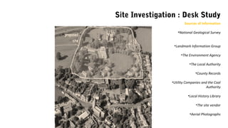
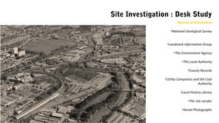
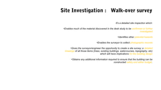
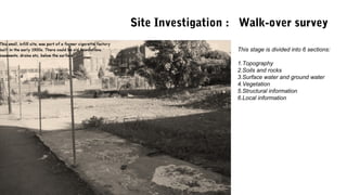
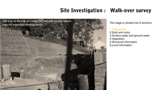
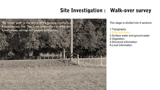
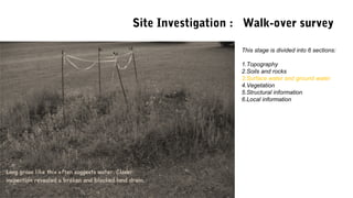
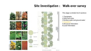
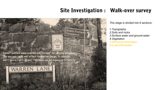
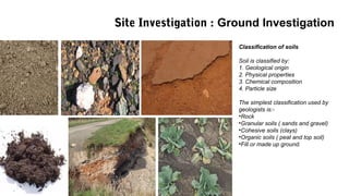
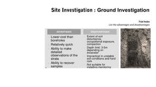
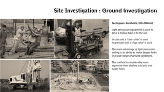
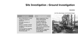
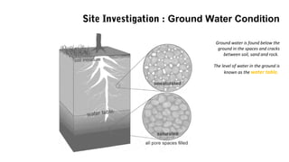
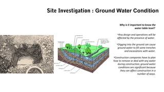
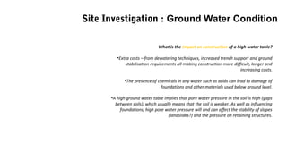
S I T E I N V E S T I G A T I O N
CONSTRUCTION METHODS & DETAILS I LECTURE 01
• A desk study.
• A walk-over survey
• A physical exploration and inspection, of the ground by means of boreholes or
trial pits. This third stage is sometimes called the ground investigation.
Site Investigation : Three stages
• The desk study is the first stage in the site investigation.
• Essentially, it comprises the collection and analysis of existing
information (records) about the site.
• The information will come from a variety of sources and, and, once
analysed, will form the basis for the second stage, the walk-over survey.
Site Investigation : Desk Study
Objectives:
•to determine the nature, past use, and condition of the site.
•to determine whether this has any implications for the proposed building and its foundations
•To ascertain primary feasibility of construction of the proposed structure on that site
•Provide A check list for closer investigation during the walk-over survey
•Identify potential hazards that may require specialist input
Site Investigation : Desk Study
Sources of Information
•National Geological Survey
•Landmark Information Group
•The Environment Agency
•The Local Authority
•County Records
•Utility Companies and the Coal
Authority
•Local History Library
•The site vendor
•Aerial Photographs
Site Investigation : Desk Study
Sources of Information
•National Geological Survey
•Landmark Information Group
•The Environment Agency
•The Local Authority
•County Records
•Utility Companies and the Coal
Authority
•Local History Library
•The site vendor
•Aerial Photographs
Site Investigation : Walk-over survey
It's a detailed site inspection which:
•Enables much of the material discovered in the desk study to be confirmed or further
investigated
•Identifies other potential hazards
•Enables the surveyor to collect photographic records
•Gives the surveyor/engineer the opportunity to create a site survey; a detailed
drawings of all those items (trees, existing buildings, watercourses, topography, etc)
which will have implications for the building design
•Obtains any additional information required to ensure that the building can be
constructed safely and within budget.
This stage is divided into 6 sections:
1.Topography
2.Soils and rocks
3.Surface water and ground water
4.Vegetation
5.Structural information
6.Local information
Site Investigation : Walk-over survey
This stage is divided into 6 sections:
1.Topography
2.Soils and rocks
3.Surface water and ground water
4.Vegetation
5.Structural information
6.Local information
Site Investigation : Walk-over survey
This stage is divided into 6 sections:
1.Topography
2.Soils and rocks
3.Surface water and ground water
4.Vegetation
5.Structural information
6.Local information
Site Investigation : Walk-over survey
This stage is divided into 6 sections:
1.Topography
2.Soils and rocks
3.Surface water and ground water
4.Vegetation
5.Structural information
6.Local information
Site Investigation : Walk-over survey
This stage is divided into 6 sections:
1.Topography
2.Soils and rocks
3.Surface water and ground water
4.Vegetation
5.Structural information
6.Local information
Site Investigation : Walk-over survey
This stage is divided into 6 sections:
1.Topography
2.Soils and rocks
3.Surface water and ground water
4.Vegetation
5.Structural information
6.Local information
Site Investigation : Walk-over survey
Key term: Geotechnical properties
How soil is likely to perform when imposing loads on it or what will happen when
water is removed to allow work to take place.
A direct ground investigation is the third stage in the site investigation. It provides detailed
information on:-
•The nature and thickness of made up ground/top soil above the subsoil.
•The nature, thickness and stratum depth of subsoil
•An assessment of allowable bearing pressure.
•Groundwater levels, chemicals in the ground etc.
•Existing structures or hazards in the ground.
Site Investigation : Ground Investigation
Key term:
How the soil will react to the building works and imposing loads.
The soil can be expected to carry a certain weight depending on its parameters
and its characteristics.
Ground investigations should provide the following:-
•Classification of soils
•Soil profile
•Soil parameters
Site Investigation : Ground Investigation
Classification of soils
Soil is classified by:
1. Geological origin
2. Physical properties
3. Chemical composition
4. Particle size
The simplest classification used by
geologists is:-
•Rock
•Granular soils ( sands and gravel)
•Cohesive soils (clays)
•Organic soils ( peat and top soil)
•Fill or made up ground.
Site Investigation : Ground Investigation
Soil profile:-
•Identification of the layers of soil
below ground level, depth and type.
•Boundaries between the various
layers/types are not always distinct,
which means it is sometimes difficult
to tell what condition will actually be
found when digging into the earth
Site Investigation : Ground Investigation
Soil Parameters:-
The load imposed by a building and the
ability of the ground to support this needs
to be quantified.
E.g. Approved Documents; Part A, Table 10
Analysis of soil type and loadings, giving
recommended foundation widths.
Site Investigation : Ground Investigation
Key term: exploratory hole
Holes sunk into the ground to extract soil samples at differing levels.
The information is recorded as the holes are drilled so that the design engineer
discovers at what depth each soil is found.
Key term: Made Ground
Any ground that has been artificially made from previous works, e.g. layers of
stone compacted and laid to form a level surface ready for construction work.
Site Investigation : Ground Investigation
Techniques: Trial pits (Max 5m deep)
Trial pits are particularly useful in the
investigation of sites intended for low –
rise construction
Records need to be kept as a ‘log’ with
the profile recorded as the hole is dug.
Trial pits are relatively cheap but care
must be taken with exposed
excavations, and some may need
shoring with timber or hydraulic earth
supports. These also need to be well
identified as open excavation can also
be dangerous to any person on site.
Trial holes
List the advantages and disadvantages
Site Investigation : Ground Investigation
Techniques: Boreholes (105-200mm)
Light percussion equipment is used to
drive a hollow tube in to the soil
In clay soils a ‘clay cutter’ is used
In granular soils a ‘flap valve’ is used
The main advantage of light percussion
drilling is its ability to make deeper holes
in a wide range of ground conditions.
This method is considerably more
expensive than shallow trial pits and
auger holes.
Site Investigation : Ground Investigation
Site Investigation: Ground Investigation
Bore hole clip
Boreholes
List the advantages and disadvantages
Site Investigation : Ground Investigation
Exploratory holes: How deep?
Depth depends on ‘stress distribution’ under the foundation.
Boreholes should penetrate all deposits unsuitable for foundation purposes such as
unconsolidated fill or materials that need compacting e.g. peat, organic silts, and very soft
compressible clays.
Depth requirements should be reconsidered when the results of the first tests have become
available, as it may be possible to reduce the depth of the subsequent borings.
Site Investigation : Ground Investigation
Exploratory holes: How many?
The maximum number of boreholes will depend on the complexity of the local geology and
construction project.
The number can change as more information becomes available from earlier investigations.
Exploratory holes: Where?
The location of boreholes is dependent on the nature of the site and proposed construction.
Additional boreholes are drilled at problem areas and near the site of the proposed structure.
Where practicable boreholes should be located along ‘grid lines’ at regular intervals to enable
section drawing to be produced across indicated planes.
Site Investigation : Ground Investigation
Ground water is found below the
ground in the spaces and cracks
between soil, sand and rock.
The level of water in the ground is
known as the water table.
Site Investigation : Ground Water Condition
Why is it important to know the
water table level?
•Any design and operations will be
affected by the presence of water.
•Digging into the ground can cause
ground water to fill some trenches
and excavations with water.
•Construction companies have to plan
how to remove or deal with any water
during construction; ground water
conditions are significant because
they can affect construction in a
number of ways.
Site Investigation : Ground Water Condition
What is the impact on construction of a high water table?
•Extra costs – from dewatering techniques, increased trench support and ground
stabilisation requirements all making construction more difficult, longer and
increasing costs.
•The presence of chemicals in any water such as acids can lead to damage of
foundations and other materials used below ground level.
•A high ground water table implies that pore water pressure in the soil is high (gaps
between soils), which usually means that the soil is weaker. As well as influencing
foundations, high pore water pressure will and can affect the stability of slopes
(landslides?) and the pressure on retaining structures.
Site Investigation : Ground Water Condition

site investigation

  • 1.
    S I TE I N V E S T I G A T I O N CONSTRUCTION METHODS & DETAILS I LECTURE 01
  • 2.
    • A deskstudy. • A walk-over survey • A physical exploration and inspection, of the ground by means of boreholes or trial pits. This third stage is sometimes called the ground investigation. Site Investigation : Three stages
  • 3.
    • The deskstudy is the first stage in the site investigation. • Essentially, it comprises the collection and analysis of existing information (records) about the site. • The information will come from a variety of sources and, and, once analysed, will form the basis for the second stage, the walk-over survey. Site Investigation : Desk Study
  • 4.
    Objectives: •to determine thenature, past use, and condition of the site. •to determine whether this has any implications for the proposed building and its foundations •To ascertain primary feasibility of construction of the proposed structure on that site •Provide A check list for closer investigation during the walk-over survey •Identify potential hazards that may require specialist input Site Investigation : Desk Study
  • 5.
    Sources of Information •NationalGeological Survey •Landmark Information Group •The Environment Agency •The Local Authority •County Records •Utility Companies and the Coal Authority •Local History Library •The site vendor •Aerial Photographs Site Investigation : Desk Study
  • 6.
    Site Investigation :Desk Study Sources of Information •National Geological Survey •Landmark Information Group •The Environment Agency •The Local Authority •County Records •Utility Companies and the Coal Authority •Local History Library •The site vendor •Aerial Photographs
  • 7.
    Site Investigation :Walk-over survey It's a detailed site inspection which: •Enables much of the material discovered in the desk study to be confirmed or further investigated •Identifies other potential hazards •Enables the surveyor to collect photographic records •Gives the surveyor/engineer the opportunity to create a site survey; a detailed drawings of all those items (trees, existing buildings, watercourses, topography, etc) which will have implications for the building design •Obtains any additional information required to ensure that the building can be constructed safely and within budget.
  • 8.
    This stage isdivided into 6 sections: 1.Topography 2.Soils and rocks 3.Surface water and ground water 4.Vegetation 5.Structural information 6.Local information Site Investigation : Walk-over survey
  • 9.
    This stage isdivided into 6 sections: 1.Topography 2.Soils and rocks 3.Surface water and ground water 4.Vegetation 5.Structural information 6.Local information Site Investigation : Walk-over survey
  • 10.
    This stage isdivided into 6 sections: 1.Topography 2.Soils and rocks 3.Surface water and ground water 4.Vegetation 5.Structural information 6.Local information Site Investigation : Walk-over survey
  • 11.
    This stage isdivided into 6 sections: 1.Topography 2.Soils and rocks 3.Surface water and ground water 4.Vegetation 5.Structural information 6.Local information Site Investigation : Walk-over survey
  • 12.
    This stage isdivided into 6 sections: 1.Topography 2.Soils and rocks 3.Surface water and ground water 4.Vegetation 5.Structural information 6.Local information Site Investigation : Walk-over survey
  • 13.
    This stage isdivided into 6 sections: 1.Topography 2.Soils and rocks 3.Surface water and ground water 4.Vegetation 5.Structural information 6.Local information Site Investigation : Walk-over survey
  • 14.
    Key term: Geotechnicalproperties How soil is likely to perform when imposing loads on it or what will happen when water is removed to allow work to take place. A direct ground investigation is the third stage in the site investigation. It provides detailed information on:- •The nature and thickness of made up ground/top soil above the subsoil. •The nature, thickness and stratum depth of subsoil •An assessment of allowable bearing pressure. •Groundwater levels, chemicals in the ground etc. •Existing structures or hazards in the ground. Site Investigation : Ground Investigation
  • 15.
    Key term: How thesoil will react to the building works and imposing loads. The soil can be expected to carry a certain weight depending on its parameters and its characteristics. Ground investigations should provide the following:- •Classification of soils •Soil profile •Soil parameters Site Investigation : Ground Investigation
  • 16.
    Classification of soils Soilis classified by: 1. Geological origin 2. Physical properties 3. Chemical composition 4. Particle size The simplest classification used by geologists is:- •Rock •Granular soils ( sands and gravel) •Cohesive soils (clays) •Organic soils ( peat and top soil) •Fill or made up ground. Site Investigation : Ground Investigation
  • 17.
    Soil profile:- •Identification ofthe layers of soil below ground level, depth and type. •Boundaries between the various layers/types are not always distinct, which means it is sometimes difficult to tell what condition will actually be found when digging into the earth Site Investigation : Ground Investigation
  • 18.
    Soil Parameters:- The loadimposed by a building and the ability of the ground to support this needs to be quantified. E.g. Approved Documents; Part A, Table 10 Analysis of soil type and loadings, giving recommended foundation widths. Site Investigation : Ground Investigation
  • 19.
    Key term: exploratoryhole Holes sunk into the ground to extract soil samples at differing levels. The information is recorded as the holes are drilled so that the design engineer discovers at what depth each soil is found. Key term: Made Ground Any ground that has been artificially made from previous works, e.g. layers of stone compacted and laid to form a level surface ready for construction work. Site Investigation : Ground Investigation
  • 20.
    Techniques: Trial pits(Max 5m deep) Trial pits are particularly useful in the investigation of sites intended for low – rise construction Records need to be kept as a ‘log’ with the profile recorded as the hole is dug. Trial pits are relatively cheap but care must be taken with exposed excavations, and some may need shoring with timber or hydraulic earth supports. These also need to be well identified as open excavation can also be dangerous to any person on site. Site Investigation : Ground Investigation
  • 21.
    Site Investigation :Ground Investigation Techniques: Trial pits (Max 5m deep) Trial pits are particularly useful in the investigation of sites intended for low – rise construction Records need to be kept as a ‘log’ with the profile recorded as the hole is dug. Trial pits are relatively cheap but care must be taken with exposed excavations, and some may need shoring with timber or hydraulic earth supports. These also need to be well identified as open excavation can also be dangerous to any person on site.
  • 22.
    Trial holes List theadvantages and disadvantages Site Investigation : Ground Investigation
  • 23.
    Techniques: Boreholes (105-200mm) Lightpercussion equipment is used to drive a hollow tube in to the soil In clay soils a ‘clay cutter’ is used In granular soils a ‘flap valve’ is used The main advantage of light percussion drilling is its ability to make deeper holes in a wide range of ground conditions. This method is considerably more expensive than shallow trial pits and auger holes. Site Investigation : Ground Investigation
  • 24.
    Site Investigation: GroundInvestigation Bore hole clip
  • 25.
    Boreholes List the advantagesand disadvantages Site Investigation : Ground Investigation
  • 26.
    Exploratory holes: Howdeep? Depth depends on ‘stress distribution’ under the foundation. Boreholes should penetrate all deposits unsuitable for foundation purposes such as unconsolidated fill or materials that need compacting e.g. peat, organic silts, and very soft compressible clays. Depth requirements should be reconsidered when the results of the first tests have become available, as it may be possible to reduce the depth of the subsequent borings. Site Investigation : Ground Investigation
  • 27.
    Exploratory holes: Howmany? The maximum number of boreholes will depend on the complexity of the local geology and construction project. The number can change as more information becomes available from earlier investigations. Exploratory holes: Where? The location of boreholes is dependent on the nature of the site and proposed construction. Additional boreholes are drilled at problem areas and near the site of the proposed structure. Where practicable boreholes should be located along ‘grid lines’ at regular intervals to enable section drawing to be produced across indicated planes. Site Investigation : Ground Investigation
  • 28.
    Ground water isfound below the ground in the spaces and cracks between soil, sand and rock. The level of water in the ground is known as the water table. Site Investigation : Ground Water Condition
  • 29.
    Why is itimportant to know the water table level? •Any design and operations will be affected by the presence of water. •Digging into the ground can cause ground water to fill some trenches and excavations with water. •Construction companies have to plan how to remove or deal with any water during construction; ground water conditions are significant because they can affect construction in a number of ways. Site Investigation : Ground Water Condition
  • 30.
    What is theimpact on construction of a high water table? •Extra costs – from dewatering techniques, increased trench support and ground stabilisation requirements all making construction more difficult, longer and increasing costs. •The presence of chemicals in any water such as acids can lead to damage of foundations and other materials used below ground level. •A high ground water table implies that pore water pressure in the soil is high (gaps between soils), which usually means that the soil is weaker. As well as influencing foundations, high pore water pressure will and can affect the stability of slopes (landslides?) and the pressure on retaining structures. Site Investigation : Ground Water Condition

Editor's Notes

  • #6 The bullet points list a number of potential sources of information for the desk study. Aerial photographs can also be useful.  
  • #7 When the desk study is complete it should be possible to produce a check list of items which require closer investigation during the walk-over survey. It may also be possible at this stage to identify hazards which require specialist input. 
  • #9 NHBC:  (National House Builders Council)
  • #10 are there any abrupt changes in slope, or excavations at the base of slopes? are there depressions or valley bottoms that may be soft or filled? are there any signs of landslip such as sloping walls or tilting trees? is there evidence of imported soil or fill? is there any sign of subsidence?
  • #11 what is the basic type of ground? is there evidence of peat, silt, or other highly compressible material? is there surface cracking or stickiness which might indicate a shrinkable clay? are there sudden changes in material, eg, clay to rock?
  • #12 is a high water table indicated , eg, by waterlogged ground? are there any signs of flooding? are there any reeds or water loving plants? are there any springs, ditches or ponds etc? is there any discoloured water, if so, what is its source?
  • #13 is the vegetation sparse, dead or dying? what is the nature of the vegetation adjoining the land? what are the species, height and condition of the trees? is there evidence of tree removal? If, following the desk study and walk-over survey, hazards are suspected specialist input will be required and more detailed investigation will be necessary.
  • #14 is there evidence of damage to buildings on, or near, the site? is there other evidence of movement? is there evidence of buildings or services below the ground? is there local knowledge regarding past use of the site? do local place names, road names, etc. help identify former use of the site?
  • #17 These broad soil classifications coupled with simple tests to determine soil parameters or to detect the presence of harmful chemicals to construction materials are normally sufficient for low rise buildings.
  • #19 Engineering design and calculations may be required to find out the soil parameters especially ground that has difficult soils such as clays since these soils perform variably. Hence the need to quantify the load imposed by a building and the ability of the ground to support this load (See table 10). E.g. rock - well Peat – very weak, therefore must transfer load to a suitable substrata below the peat (pile foundations).
  • #21 Extremely valuable if the depth of the investigation is limited to approx 5m or less. Can be excavated using a back-actor or 360 degree slew hydraulic excavator. Trial pits are particularly useful in the investigation of sites intended for low – rise construction because the foundation type for this type of structure is generally 0.4 to 0.6m wide and max 3m deep. Thus the depth would be around 3 to 5m.
  • #22 For low rise housing, on green-field sites, machine-dug trial pits are probably the most common method of ground investigation. The pits do not normally need to be deeper than 4-5 metres unless specific problems are encountered. BS 8103 states that; "The depth of the trial pits should be at least 2 metres. If, at this depth,  the ground is unsuitable for the proposed foundations, (ie, strip foundations) a suitable qualified person should be consulted". Trial pits should be excavated close to the proposed foundation, but not so close as to affect its actual construction. The number of pits is usually a matter for judgement and will depend on the size of the proposed development, the nature of the site, and the consistency of the soil across the site.
  • #23 For low rise housing, on green-field sites, machine-dug trial pits are probably the most common method of ground investigation. The pits do not normally need to be deeper than 4-5 metres unless specific problems are encountered. BS 8103 states that; "The depth of the trial pits should be at least 2 metres. If, at this depth,  the ground is unsuitable for the proposed foundations, (ie, strip foundations) a suitable qualified person should be consulted". Trial pits should be excavated close to the proposed foundation, but not so close as to affect its actual construction. The number of pits is usually a matter for judgement and will depend on the size of the proposed development, the nature of the site, and the consistency of the soil across the site.
  • #24 Clay cutter – dropping a hollow tube into the clay so that the clay becomes lodged in the base. The clay cutter and contents is then carefully lifted to the surface. Flap Valve – hollow tube is pressed into ground using water pressure creating a water/soil mix. Soil drops out of this mixture are collected and retained as ‘disturbed samples. Can be analysed in a lab to determine it’s load bearing capacity.
  • #25 Clay cutter – dropping a hollow tube into the clay so that the clay becomes lodged in the base. The clay cutter and contents is then carefully lifted to the surface. Flap Valve – hollow tube is pressed into ground using water pressure creating a water/soil mix. Soil drops out of this mixture are collected and retained as ‘disturbed samples. Can be analysed in a lab to determine it’s load bearing capacity.
  • #27 Compressible clay can be compressed to increase its strength or load bearing capacity.
  • #28 Grid lines – An imaginary series of lines running north/south and east/west allows designers and engineers to plot exactly the key positions on the site. Section drawings: A profile of the ground using information from the boreholes next to one another. This allows the engineers to predict what happens to the ground between each borehole.
  • #31 Pore-water pressure is the pressure that water exerts on the ground as it moves through the fissures and cracks in the ground Retaining structures – walls or buildings that hold back or support the earth.