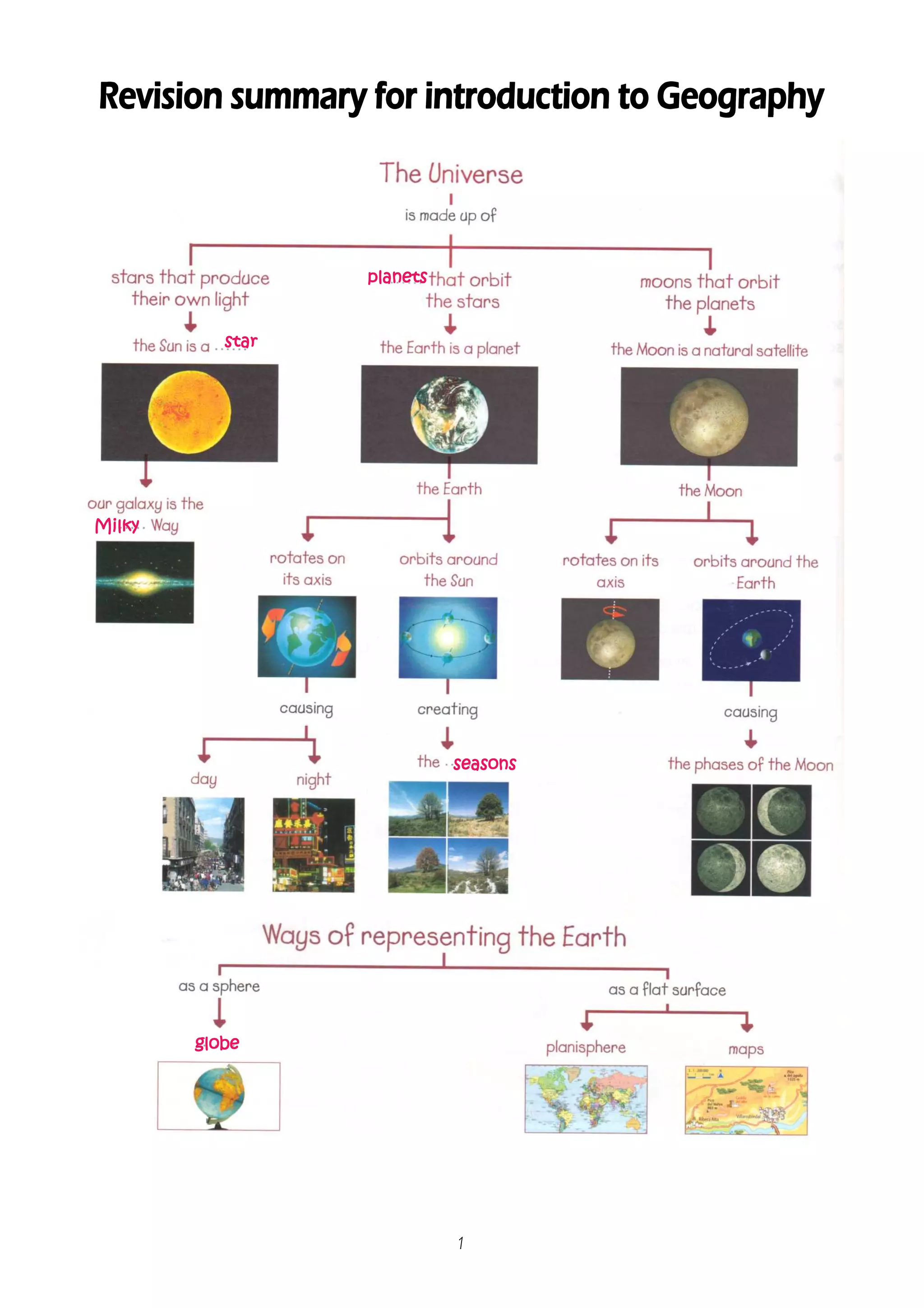
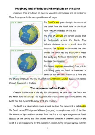
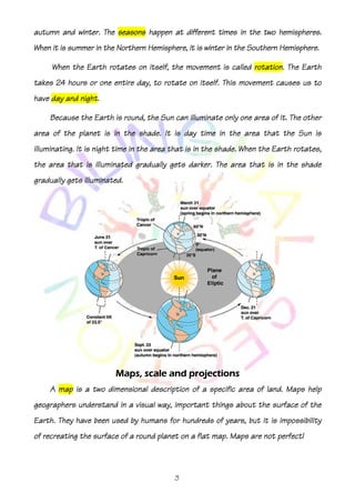
planets


           star


Milky


                            seasons


        globe


                            1
Imaginary lines of latitude and longitude on the Earth
    Imaginary lines are drawn on maps to describe where places are on the Earth.
                               positions
These lines appear in the same positions on all maps

                                       The Earth's axis goes through the centre of
                                       the Earth from the North Pole to the South
                                       Pole. The Earth rotates on this axis

                                       The lines of latitude are parallel circles that
                                       go horizontally around the Earth. They
                                                                  south
                                       indicate distance north or south from the
                                       Equator. The Equator is the middle line that
                                       divides the Earth into two equal parts. These
                                       two parts are Northern Hemisphere and the
                                       Southern Hemispheres

                                       The lines of longitude go vertically from pole to
                                       pole. Every point on Earth is measured iin
                                                                                n
                                       terms of how far east or west it is from the
line of zero longitude. This line is called the Greenwich Meridian because it passes
through Greenwich in England

                        The movements of the Earth
    Celestial bodies move in the sky. For this reason, we know that the Earth and
the Moon move in the sky. This happens even if we cannot feel the movement. The
Earth has two movements, called orbit and rotation.

                                                                              orbit.
    The Earth is a planet which moves around the Sun. This movement is called orbit.
The Earth takes 365 days and 6 hours (one year) to complete one orbit of the Sun.
The amount of light and heat received form the Sun is not equal everywhere on Earth
because of the Earth's tilt. This causes different climates in different areas of the
world. It is also responsible for the changes in season during the year: spring, summer,

                                           2
hemispheres.
autumn and winter. The seasons happen at different times in the two hemispheres.
When it is summer in the Northern Hemisphere, it is winter in the Southern Hemisphere.

                               itself,                        rotation.
     When the Earth rotates on itself, the movement is called rotation. The Earth
takes 24 hours or one entire day, to rotate on itself. This movement causes us to
             night.
have day and night.

    Because the Earth is round, the Sun can illuminate only one area of it. The other
                         the
area of the planet is in the shade. It is day time in the area that the Sun is
illuminating. It is night time in the area that is in the shade. When the Earth rotates,
the area that is illuminated gradually gets darker. The area that is in the shade
gradually gets illuminated.


                         Maps,
                         Maps, scale and projections
    A map is a two dimensional description of a specific area of land. Maps help
geographers understand in a visual way, important things about the surface of the
Earth. They have been used by humans for hundreds of years, but it is impossibility
                                                                      impossibility
of recreating the surface of a round planet on a flat map. Maps are not perfect!


                                           3
Maps can represent a variety of
                                                     information. This information includes things
                                                     such roads, tourist attractions or towns.
                                                     Something can help us understand maps. For
                                                     example, title, legend, scale, geographic
                                                     coordinates or projection. The objects on a
                                                     map are represented using symbols. A symbol
                                                          picture
                                                     is a picture on the map that represents
                                                     something in the real world. To read a map
                                                     you need to understand compass directions
(showing which way is up —North-), grid references (numbered squares), the map's key
                          North-
(the reader knows what the symbols on the map represent) and scale (the reader can
                                                                   (the
translate distances shown on the map into distances on the ground). Make sure
                                                           ground).
         the
you read the title of a map before you start to use it (eg land use or vegetation cover).
This will give you a general idea about the information it stores.

 The scale below is for a 1:50,000 scale       The scale is the proportion between the real size of
 map. At this scale, 1 cm on the map
 represents 50,000 cm on the ground        the represented territory and the corresponding size on
 (= 500 m or 0.5 km)
                                           the map. For example, your map has a scale of 1:25 000,
                                           which means that every 1 cm on the map represents
                                           25000
                                           25000 of those same units of measurement on the
                                           ground (for example, 25000 cm = 250 metres). There
                                                                25000
                                           are three common methods used by map makers to
                                           depict
                                           depict scale: graphic method and fractional method.

                                                                   3-
     A map projection is any of many methods used to represent the 3-dimensional
                          2-
surface of the Earth on a 2-dimensional plane in cartography. There are three map
                                        plane.
projection types: cylindrical, cone and plane.


                                                      4

Revision Summary 00 GEO

  • 1.
    planets star Milky seasons globe 1
  • 2.
    Imaginary lines oflatitude and longitude on the Earth Imaginary lines are drawn on maps to describe where places are on the Earth. positions These lines appear in the same positions on all maps The Earth's axis goes through the centre of the Earth from the North Pole to the South Pole. The Earth rotates on this axis The lines of latitude are parallel circles that go horizontally around the Earth. They south indicate distance north or south from the Equator. The Equator is the middle line that divides the Earth into two equal parts. These two parts are Northern Hemisphere and the Southern Hemispheres The lines of longitude go vertically from pole to pole. Every point on Earth is measured iin n terms of how far east or west it is from the line of zero longitude. This line is called the Greenwich Meridian because it passes through Greenwich in England The movements of the Earth Celestial bodies move in the sky. For this reason, we know that the Earth and the Moon move in the sky. This happens even if we cannot feel the movement. The Earth has two movements, called orbit and rotation. orbit. The Earth is a planet which moves around the Sun. This movement is called orbit. The Earth takes 365 days and 6 hours (one year) to complete one orbit of the Sun. The amount of light and heat received form the Sun is not equal everywhere on Earth because of the Earth's tilt. This causes different climates in different areas of the world. It is also responsible for the changes in season during the year: spring, summer, 2
  • 3.
    hemispheres. autumn and winter.The seasons happen at different times in the two hemispheres. When it is summer in the Northern Hemisphere, it is winter in the Southern Hemisphere. itself, rotation. When the Earth rotates on itself, the movement is called rotation. The Earth takes 24 hours or one entire day, to rotate on itself. This movement causes us to night. have day and night. Because the Earth is round, the Sun can illuminate only one area of it. The other the area of the planet is in the shade. It is day time in the area that the Sun is illuminating. It is night time in the area that is in the shade. When the Earth rotates, the area that is illuminated gradually gets darker. The area that is in the shade gradually gets illuminated. Maps, Maps, scale and projections A map is a two dimensional description of a specific area of land. Maps help geographers understand in a visual way, important things about the surface of the Earth. They have been used by humans for hundreds of years, but it is impossibility impossibility of recreating the surface of a round planet on a flat map. Maps are not perfect! 3
  • 4.
    Maps can representa variety of information. This information includes things such roads, tourist attractions or towns. Something can help us understand maps. For example, title, legend, scale, geographic coordinates or projection. The objects on a map are represented using symbols. A symbol picture is a picture on the map that represents something in the real world. To read a map you need to understand compass directions (showing which way is up —North-), grid references (numbered squares), the map's key North- (the reader knows what the symbols on the map represent) and scale (the reader can (the translate distances shown on the map into distances on the ground). Make sure ground). the you read the title of a map before you start to use it (eg land use or vegetation cover). This will give you a general idea about the information it stores. The scale below is for a 1:50,000 scale The scale is the proportion between the real size of map. At this scale, 1 cm on the map represents 50,000 cm on the ground the represented territory and the corresponding size on (= 500 m or 0.5 km) the map. For example, your map has a scale of 1:25 000, which means that every 1 cm on the map represents 25000 25000 of those same units of measurement on the ground (for example, 25000 cm = 250 metres). There 25000 are three common methods used by map makers to depict depict scale: graphic method and fractional method. 3- A map projection is any of many methods used to represent the 3-dimensional 2- surface of the Earth on a 2-dimensional plane in cartography. There are three map plane. projection types: cylindrical, cone and plane. 4