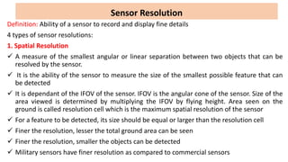
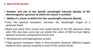
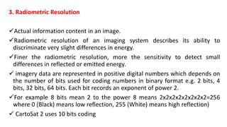
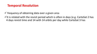
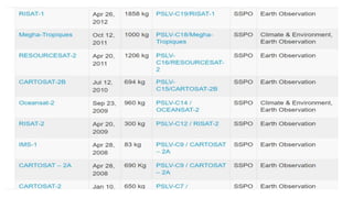
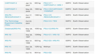
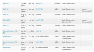
SlideShare a Scribd company logo
1 of 11
Sensor Resolution
Definition: Ability of a sensor to record and display fine details
4 types of sensor resolutions:
1. Spatial Resolution
 A measure of the smallest angular or linear separation between two objects that can be
resolved by the sensor.
 It is the ability of the sensor to measure the size of the smallest possible feature that can
be detected
 It is dependant of the IFOV of the sensor. IFOV is the angular cone of the sensor. Size of the
area viewed is determined by multiplying the IFOV by flying height. Area seen on the
ground is called resolution cell which is the maximum spatial resolution of the sensor
 For a feature to be detected, its size should be equal or larger than the resolution cell
 Finer the resolution, lesser the total ground area can be seen
 Finer the resolution, smaller the objects can be detected
 Military sensors have finer resolution as compared to commercial sensors
2. Spectral Resolution
 Number and size of the specific wavelength intervals (bands) of the
electromagnetic spectrum to which the sensor is sensitive
 Ability of a sensor to define the fine wavelengths intervals (bands)
Finer the spectral resolution, narrower the wavelength ranges of a
particular band
Black and white films record only visible bands of the EM spectrum while
color film also does same but can detect the colors of RGB so have higher
spectral resolution compared to former one
 Multispectral and Hyperspectral sensors
 High spectral resolution helps in discrimination between different targets
based on their spectral response in each of the narrow bands
3. Radiometric Resolution
Actual information content in an image.
Radiometric resolution of an imaging system describes its ability to
discriminate very slight differences in energy.
Finer the radiometric resolution, more the sensitivity to detect small
differences in reflected or emitted energy.
 imagery data are represented in positive digital numbers which depends on
the number of bits used for coding numbers in binary format e.g. 2 bits, 4
bits, 32 bits, 64 bits. Each bit records an exponent of power 2.
For example 8 bits mean 2 to the power 8 means 2x2x2x2x2x2x2x2=256
where 0 (Black) means low reflection, 255 (White) means high reflection)
 CartoSat 2 uses 10 bits coding
Temporal Resolution
 frequency of obtaining data over a given area
It is related with the revisit period which is often in days (e.g. CartoSat 2 has
4 days revisit time and 14 with 14 orbits per day while CartoSat 3 has
The Saga of Indian Remote Sensing Satellite System
• IRS-1A, the first of the series of indigenous state-of-art operating remote
sensing satellites, was successfully launched into a polar sun-synchronous
orbit on March 17, 1988 from the Soviet Cosmodrome at Baikonur.
• The successful launch of IRS-1A was one of the proudest moments for the
entire country, which depicted the maturity of satellite to address the various
requirements for managing natural resources of the nation. Its LISS-I had a
spatial resolution of 72.5 meters with a swath of 148 km on ground sensors,
LISS-II A and LISS-II B, with spatial resolution of 36.25 meters each and
mounted on the spacecraft in such a way to provide a composite swath of
146.98 km on ground. LISS-II had two separate imaging sensors
• The IRS-1A satellite, with its LISS-I and LISS-II sensors quickly enabled
India to map, monitor and manage its natural resources at coarse and
medium spatial resolutions. The operational availability of data products to
the user organisations further strengthened the operationalisation of remote
sensing applications and management in the country.
• Starting with IRS-1A in 1988, ISRO has launched many
operational remote sensing satellites. Today, India has one of
the largest constellations of remote sensing satellites in
operation. Currently, *thirteen* operational satellites are in Sun-
synchronous orbit – RESOURCESAT-1, 2, 2A CARTOSAT-1, 2,
2A, 2B, RISAT-1 and 2, OCEANSAT-2, Megha-Tropiques,
SARAL and SCATSAT-1, and *four* in Geostationary orbit-
INSAT-3D, Kalpana & INSAT 3A, INSAT -3DR.
• The data from these satellites are used for several applications
covering agriculture, water resources, urban planning, rural
development, mineral prospecting, environment, forestry, ocean
resources and disaster management.
Resolution.pptx remote sensing resolution

More Related Content

Similar to Resolution.pptx remote sensing resolution

Remote Sensing: Meaning, Concept and Components | Geography
Remote Sensing: Meaning, Concept and Components | GeographyRemote Sensing: Meaning, Concept and Components | Geography
Remote Sensing: Meaning, Concept and Components | GeographySrimantaKarak
 
Remote sensing
 Remote sensing Remote sensing
Remote sensingFidy Zegge
 
Hyperspectral & Remote Sensing on Remote Sensing and GIS.pptx
Hyperspectral & Remote Sensing on Remote Sensing and GIS.pptxHyperspectral & Remote Sensing on Remote Sensing and GIS.pptx
Hyperspectral & Remote Sensing on Remote Sensing and GIS.pptxKabaliVasudevasu
 
Basics of Remote Sensing
Basics of Remote SensingBasics of Remote Sensing
Basics of Remote SensingAkash Tikhe
 
Unit 1 introduction to remote sensing
Unit  1 introduction to remote sensing Unit  1 introduction to remote sensing
Unit 1 introduction to remote sensing Dhanalakshmi Dasari
 
rsbasics-150227022648-conversion-gate01.pptx
rsbasics-150227022648-conversion-gate01.pptxrsbasics-150227022648-conversion-gate01.pptx
rsbasics-150227022648-conversion-gate01.pptxBSuresh26
 
Continuing chapter rs.pptx
Continuing chapter rs.pptxContinuing chapter rs.pptx
Continuing chapter rs.pptxThomasHundasa1
 
1Resolutions of Remote Sensing1. Spatial (what area an.docx
1Resolutions of Remote Sensing1. Spatial (what area an.docx1Resolutions of Remote Sensing1. Spatial (what area an.docx
1Resolutions of Remote Sensing1. Spatial (what area an.docxaulasnilda
 
Surveying ii ajith sir class4
Surveying ii ajith sir class4Surveying ii ajith sir class4
Surveying ii ajith sir class4SHAMJITH KM
 
High resolution data
High resolution dataHigh resolution data
High resolution dataPrem Chandra
 
Lrm 111 intro remote sensing lesson iv
Lrm 111 intro remote sensing lesson ivLrm 111 intro remote sensing lesson iv
Lrm 111 intro remote sensing lesson ivmusadoto
 
RS - Presentation by AP2023.pptx
RS - Presentation by AP2023.pptxRS - Presentation by AP2023.pptx
RS - Presentation by AP2023.pptxDrAbhishekPandey9
 
Optical remote sensing
Optical remote sensingOptical remote sensing
Optical remote sensingSumant Diwakar
 

Similar to Resolution.pptx remote sensing resolution (20)

Remote sensing
Remote sensingRemote sensing
Remote sensing
 
Remote Sensing: Meaning, Concept and Components | Geography
Remote Sensing: Meaning, Concept and Components | GeographyRemote Sensing: Meaning, Concept and Components | Geography
Remote Sensing: Meaning, Concept and Components | Geography
 
Remote sensing
 Remote sensing Remote sensing
Remote sensing
 
Remote sensing
Remote sensingRemote sensing
Remote sensing
 
Hyperspectral & Remote Sensing on Remote Sensing and GIS.pptx
Hyperspectral & Remote Sensing on Remote Sensing and GIS.pptxHyperspectral & Remote Sensing on Remote Sensing and GIS.pptx
Hyperspectral & Remote Sensing on Remote Sensing and GIS.pptx
 
Basics of Remote Sensing
Basics of Remote SensingBasics of Remote Sensing
Basics of Remote Sensing
 
Unit 1 introduction to remote sensing
Unit  1 introduction to remote sensing Unit  1 introduction to remote sensing
Unit 1 introduction to remote sensing
 
rsbasics-150227022648-conversion-gate01.pptx
rsbasics-150227022648-conversion-gate01.pptxrsbasics-150227022648-conversion-gate01.pptx
rsbasics-150227022648-conversion-gate01.pptx
 
Continuing chapter rs.pptx
Continuing chapter rs.pptxContinuing chapter rs.pptx
Continuing chapter rs.pptx
 
1Resolutions of Remote Sensing1. Spatial (what area an.docx
1Resolutions of Remote Sensing1. Spatial (what area an.docx1Resolutions of Remote Sensing1. Spatial (what area an.docx
1Resolutions of Remote Sensing1. Spatial (what area an.docx
 
Remote Sensin
Remote SensinRemote Sensin
Remote Sensin
 
IRS Sattellite
IRS SattelliteIRS Sattellite
IRS Sattellite
 
Surveying ii ajith sir class4
Surveying ii ajith sir class4Surveying ii ajith sir class4
Surveying ii ajith sir class4
 
High resolution data
High resolution dataHigh resolution data
High resolution data
 
IRSP6
IRSP6IRSP6
IRSP6
 
Lrm 111 intro remote sensing lesson iv
Lrm 111 intro remote sensing lesson ivLrm 111 intro remote sensing lesson iv
Lrm 111 intro remote sensing lesson iv
 
RS - Presentation by AP2023.pptx
RS - Presentation by AP2023.pptxRS - Presentation by AP2023.pptx
RS - Presentation by AP2023.pptx
 
SENSORS
SENSORSSENSORS
SENSORS
 
Rs
RsRs
Rs
 
Optical remote sensing
Optical remote sensingOptical remote sensing
Optical remote sensing
 

Recently uploaded

SOC 101 Demonstration of Learning Presentation
SOC 101 Demonstration of Learning PresentationSOC 101 Demonstration of Learning Presentation
SOC 101 Demonstration of Learning Presentationcamerronhm
 
Graduate Outcomes Presentation Slides - English
Graduate Outcomes Presentation Slides - EnglishGraduate Outcomes Presentation Slides - English
Graduate Outcomes Presentation Slides - Englishneillewis46
 
Exploring_the_Narrative_Style_of_Amitav_Ghoshs_Gun_Island.pptx
Exploring_the_Narrative_Style_of_Amitav_Ghoshs_Gun_Island.pptxExploring_the_Narrative_Style_of_Amitav_Ghoshs_Gun_Island.pptx
Exploring_the_Narrative_Style_of_Amitav_Ghoshs_Gun_Island.pptxPooja Bhuva
 
On_Translating_a_Tamil_Poem_by_A_K_Ramanujan.pptx
On_Translating_a_Tamil_Poem_by_A_K_Ramanujan.pptxOn_Translating_a_Tamil_Poem_by_A_K_Ramanujan.pptx
On_Translating_a_Tamil_Poem_by_A_K_Ramanujan.pptxPooja Bhuva
 
Tatlong Kwento ni Lola basyang-1.pdf arts
Tatlong Kwento ni Lola basyang-1.pdf artsTatlong Kwento ni Lola basyang-1.pdf arts
Tatlong Kwento ni Lola basyang-1.pdf artsNbelano25
 
Accessible Digital Futures project (20/03/2024)
Accessible Digital Futures project (20/03/2024)Accessible Digital Futures project (20/03/2024)
Accessible Digital Futures project (20/03/2024)Jisc
 
Details on CBSE Compartment Exam.pptx1111
Details on CBSE Compartment Exam.pptx1111Details on CBSE Compartment Exam.pptx1111
Details on CBSE Compartment Exam.pptx1111GangaMaiya1
 
Philosophy of china and it's charactistics
Philosophy of china and it's charactisticsPhilosophy of china and it's charactistics
Philosophy of china and it's charactisticshameyhk98
 
80 ĐỀ THI THỬ TUYỂN SINH TIẾNG ANH VÀO 10 SỞ GD – ĐT THÀNH PHỐ HỒ CHÍ MINH NĂ...
80 ĐỀ THI THỬ TUYỂN SINH TIẾNG ANH VÀO 10 SỞ GD – ĐT THÀNH PHỐ HỒ CHÍ MINH NĂ...80 ĐỀ THI THỬ TUYỂN SINH TIẾNG ANH VÀO 10 SỞ GD – ĐT THÀNH PHỐ HỒ CHÍ MINH NĂ...
80 ĐỀ THI THỬ TUYỂN SINH TIẾNG ANH VÀO 10 SỞ GD – ĐT THÀNH PHỐ HỒ CHÍ MINH NĂ...Nguyen Thanh Tu Collection
 
Understanding Accommodations and Modifications
Understanding  Accommodations and ModificationsUnderstanding  Accommodations and Modifications
Understanding Accommodations and ModificationsMJDuyan
 
How to Create and Manage Wizard in Odoo 17
How to Create and Manage Wizard in Odoo 17How to Create and Manage Wizard in Odoo 17
How to Create and Manage Wizard in Odoo 17Celine George
 
Food safety_Challenges food safety laboratories_.pdf
Food safety_Challenges food safety laboratories_.pdfFood safety_Challenges food safety laboratories_.pdf
Food safety_Challenges food safety laboratories_.pdfSherif Taha
 
dusjagr & nano talk on open tools for agriculture research and learning
dusjagr & nano talk on open tools for agriculture research and learningdusjagr & nano talk on open tools for agriculture research and learning
dusjagr & nano talk on open tools for agriculture research and learningMarc Dusseiller Dusjagr
 
Google Gemini An AI Revolution in Education.pptx
Google Gemini An AI Revolution in Education.pptxGoogle Gemini An AI Revolution in Education.pptx
Google Gemini An AI Revolution in Education.pptxDr. Sarita Anand
 
Single or Multiple melodic lines structure
Single or Multiple melodic lines structureSingle or Multiple melodic lines structure
Single or Multiple melodic lines structuredhanjurrannsibayan2
 
How to setup Pycharm environment for Odoo 17.pptx
How to setup Pycharm environment for Odoo 17.pptxHow to setup Pycharm environment for Odoo 17.pptx
How to setup Pycharm environment for Odoo 17.pptxCeline George
 
FICTIONAL SALESMAN/SALESMAN SNSW 2024.pdf
FICTIONAL SALESMAN/SALESMAN SNSW 2024.pdfFICTIONAL SALESMAN/SALESMAN SNSW 2024.pdf
FICTIONAL SALESMAN/SALESMAN SNSW 2024.pdfPondicherry University
 
Sensory_Experience_and_Emotional_Resonance_in_Gabriel_Okaras_The_Piano_and_Th...
Sensory_Experience_and_Emotional_Resonance_in_Gabriel_Okaras_The_Piano_and_Th...Sensory_Experience_and_Emotional_Resonance_in_Gabriel_Okaras_The_Piano_and_Th...
Sensory_Experience_and_Emotional_Resonance_in_Gabriel_Okaras_The_Piano_and_Th...Pooja Bhuva
 
Basic Civil Engineering first year Notes- Chapter 4 Building.pptx
Basic Civil Engineering first year Notes- Chapter 4 Building.pptxBasic Civil Engineering first year Notes- Chapter 4 Building.pptx
Basic Civil Engineering first year Notes- Chapter 4 Building.pptxDenish Jangid
 

Recently uploaded (20)

SOC 101 Demonstration of Learning Presentation
SOC 101 Demonstration of Learning PresentationSOC 101 Demonstration of Learning Presentation
SOC 101 Demonstration of Learning Presentation
 
Graduate Outcomes Presentation Slides - English
Graduate Outcomes Presentation Slides - EnglishGraduate Outcomes Presentation Slides - English
Graduate Outcomes Presentation Slides - English
 
Exploring_the_Narrative_Style_of_Amitav_Ghoshs_Gun_Island.pptx
Exploring_the_Narrative_Style_of_Amitav_Ghoshs_Gun_Island.pptxExploring_the_Narrative_Style_of_Amitav_Ghoshs_Gun_Island.pptx
Exploring_the_Narrative_Style_of_Amitav_Ghoshs_Gun_Island.pptx
 
On_Translating_a_Tamil_Poem_by_A_K_Ramanujan.pptx
On_Translating_a_Tamil_Poem_by_A_K_Ramanujan.pptxOn_Translating_a_Tamil_Poem_by_A_K_Ramanujan.pptx
On_Translating_a_Tamil_Poem_by_A_K_Ramanujan.pptx
 
Tatlong Kwento ni Lola basyang-1.pdf arts
Tatlong Kwento ni Lola basyang-1.pdf artsTatlong Kwento ni Lola basyang-1.pdf arts
Tatlong Kwento ni Lola basyang-1.pdf arts
 
Accessible Digital Futures project (20/03/2024)
Accessible Digital Futures project (20/03/2024)Accessible Digital Futures project (20/03/2024)
Accessible Digital Futures project (20/03/2024)
 
Details on CBSE Compartment Exam.pptx1111
Details on CBSE Compartment Exam.pptx1111Details on CBSE Compartment Exam.pptx1111
Details on CBSE Compartment Exam.pptx1111
 
Philosophy of china and it's charactistics
Philosophy of china and it's charactisticsPhilosophy of china and it's charactistics
Philosophy of china and it's charactistics
 
80 ĐỀ THI THỬ TUYỂN SINH TIẾNG ANH VÀO 10 SỞ GD – ĐT THÀNH PHỐ HỒ CHÍ MINH NĂ...
80 ĐỀ THI THỬ TUYỂN SINH TIẾNG ANH VÀO 10 SỞ GD – ĐT THÀNH PHỐ HỒ CHÍ MINH NĂ...80 ĐỀ THI THỬ TUYỂN SINH TIẾNG ANH VÀO 10 SỞ GD – ĐT THÀNH PHỐ HỒ CHÍ MINH NĂ...
80 ĐỀ THI THỬ TUYỂN SINH TIẾNG ANH VÀO 10 SỞ GD – ĐT THÀNH PHỐ HỒ CHÍ MINH NĂ...
 
Understanding Accommodations and Modifications
Understanding  Accommodations and ModificationsUnderstanding  Accommodations and Modifications
Understanding Accommodations and Modifications
 
How to Create and Manage Wizard in Odoo 17
How to Create and Manage Wizard in Odoo 17How to Create and Manage Wizard in Odoo 17
How to Create and Manage Wizard in Odoo 17
 
Food safety_Challenges food safety laboratories_.pdf
Food safety_Challenges food safety laboratories_.pdfFood safety_Challenges food safety laboratories_.pdf
Food safety_Challenges food safety laboratories_.pdf
 
dusjagr & nano talk on open tools for agriculture research and learning
dusjagr & nano talk on open tools for agriculture research and learningdusjagr & nano talk on open tools for agriculture research and learning
dusjagr & nano talk on open tools for agriculture research and learning
 
Google Gemini An AI Revolution in Education.pptx
Google Gemini An AI Revolution in Education.pptxGoogle Gemini An AI Revolution in Education.pptx
Google Gemini An AI Revolution in Education.pptx
 
Mehran University Newsletter Vol-X, Issue-I, 2024
Mehran University Newsletter Vol-X, Issue-I, 2024Mehran University Newsletter Vol-X, Issue-I, 2024
Mehran University Newsletter Vol-X, Issue-I, 2024
 
Single or Multiple melodic lines structure
Single or Multiple melodic lines structureSingle or Multiple melodic lines structure
Single or Multiple melodic lines structure
 
How to setup Pycharm environment for Odoo 17.pptx
How to setup Pycharm environment for Odoo 17.pptxHow to setup Pycharm environment for Odoo 17.pptx
How to setup Pycharm environment for Odoo 17.pptx
 
FICTIONAL SALESMAN/SALESMAN SNSW 2024.pdf
FICTIONAL SALESMAN/SALESMAN SNSW 2024.pdfFICTIONAL SALESMAN/SALESMAN SNSW 2024.pdf
FICTIONAL SALESMAN/SALESMAN SNSW 2024.pdf
 
Sensory_Experience_and_Emotional_Resonance_in_Gabriel_Okaras_The_Piano_and_Th...
Sensory_Experience_and_Emotional_Resonance_in_Gabriel_Okaras_The_Piano_and_Th...Sensory_Experience_and_Emotional_Resonance_in_Gabriel_Okaras_The_Piano_and_Th...
Sensory_Experience_and_Emotional_Resonance_in_Gabriel_Okaras_The_Piano_and_Th...
 
Basic Civil Engineering first year Notes- Chapter 4 Building.pptx
Basic Civil Engineering first year Notes- Chapter 4 Building.pptxBasic Civil Engineering first year Notes- Chapter 4 Building.pptx
Basic Civil Engineering first year Notes- Chapter 4 Building.pptx
 

Resolution.pptx remote sensing resolution

  • 1. Sensor Resolution Definition: Ability of a sensor to record and display fine details 4 types of sensor resolutions: 1. Spatial Resolution  A measure of the smallest angular or linear separation between two objects that can be resolved by the sensor.  It is the ability of the sensor to measure the size of the smallest possible feature that can be detected  It is dependant of the IFOV of the sensor. IFOV is the angular cone of the sensor. Size of the area viewed is determined by multiplying the IFOV by flying height. Area seen on the ground is called resolution cell which is the maximum spatial resolution of the sensor  For a feature to be detected, its size should be equal or larger than the resolution cell  Finer the resolution, lesser the total ground area can be seen  Finer the resolution, smaller the objects can be detected  Military sensors have finer resolution as compared to commercial sensors
  • 2. 2. Spectral Resolution  Number and size of the specific wavelength intervals (bands) of the electromagnetic spectrum to which the sensor is sensitive  Ability of a sensor to define the fine wavelengths intervals (bands) Finer the spectral resolution, narrower the wavelength ranges of a particular band Black and white films record only visible bands of the EM spectrum while color film also does same but can detect the colors of RGB so have higher spectral resolution compared to former one  Multispectral and Hyperspectral sensors  High spectral resolution helps in discrimination between different targets based on their spectral response in each of the narrow bands
  • 3. 3. Radiometric Resolution Actual information content in an image. Radiometric resolution of an imaging system describes its ability to discriminate very slight differences in energy. Finer the radiometric resolution, more the sensitivity to detect small differences in reflected or emitted energy.  imagery data are represented in positive digital numbers which depends on the number of bits used for coding numbers in binary format e.g. 2 bits, 4 bits, 32 bits, 64 bits. Each bit records an exponent of power 2. For example 8 bits mean 2 to the power 8 means 2x2x2x2x2x2x2x2=256 where 0 (Black) means low reflection, 255 (White) means high reflection)  CartoSat 2 uses 10 bits coding
  • 4. Temporal Resolution  frequency of obtaining data over a given area It is related with the revisit period which is often in days (e.g. CartoSat 2 has 4 days revisit time and 14 with 14 orbits per day while CartoSat 3 has
  • 5. The Saga of Indian Remote Sensing Satellite System • IRS-1A, the first of the series of indigenous state-of-art operating remote sensing satellites, was successfully launched into a polar sun-synchronous orbit on March 17, 1988 from the Soviet Cosmodrome at Baikonur. • The successful launch of IRS-1A was one of the proudest moments for the entire country, which depicted the maturity of satellite to address the various requirements for managing natural resources of the nation. Its LISS-I had a spatial resolution of 72.5 meters with a swath of 148 km on ground sensors, LISS-II A and LISS-II B, with spatial resolution of 36.25 meters each and mounted on the spacecraft in such a way to provide a composite swath of 146.98 km on ground. LISS-II had two separate imaging sensors • The IRS-1A satellite, with its LISS-I and LISS-II sensors quickly enabled India to map, monitor and manage its natural resources at coarse and medium spatial resolutions. The operational availability of data products to the user organisations further strengthened the operationalisation of remote sensing applications and management in the country.
  • 6. • Starting with IRS-1A in 1988, ISRO has launched many operational remote sensing satellites. Today, India has one of the largest constellations of remote sensing satellites in operation. Currently, *thirteen* operational satellites are in Sun- synchronous orbit – RESOURCESAT-1, 2, 2A CARTOSAT-1, 2, 2A, 2B, RISAT-1 and 2, OCEANSAT-2, Megha-Tropiques, SARAL and SCATSAT-1, and *four* in Geostationary orbit- INSAT-3D, Kalpana & INSAT 3A, INSAT -3DR. • The data from these satellites are used for several applications covering agriculture, water resources, urban planning, rural development, mineral prospecting, environment, forestry, ocean resources and disaster management.