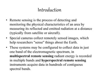
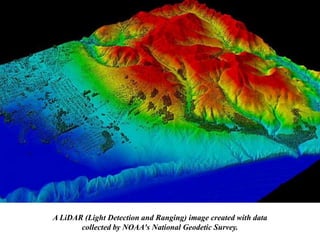
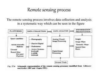
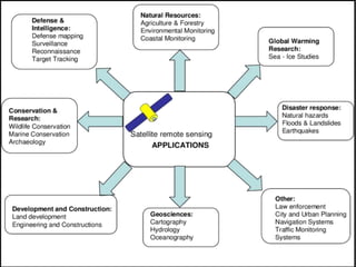
Remote sensing is the process of detecting and monitoring the physical characteristics of an area by measuring its reflected and emitted radiation at a distance (typically from satellite or aircraft).
Special cameras collect remotely sensed images, which help researchers "sense" things about the Earth.
Remote sensing application in agriculture & forestry_Dr Menon A R R (The Kera...India Water Portal
This presentation by Dr A R R Menon, Emeritus scientist, CED on Remote Sensing applications in agriculture and forestry was made at at the Kerala Environment Congress, Trivandrum organised by the Centre for Environment and Development
Application of Remote Sensing in AgricultureUTTAM KUMAR
Remote sensing has been found to be a valuable tool in evaluation, monitoring and management of land, water and crop resources. The launching of the Indian remote sensing satellite (IRS) has enhanced the capabilities for better utilization of this technology and significant progress has been made in soil and land cover mapping, land degradation studies, monitoring of waste land, assessment of crop conditions crop acreage and production estimates
GIS in agriculture helps farmers to achieve increased production and reduced costs by enabling better management of land resources. The risk of marginalization and vulnerability of small and marginal farmers, who constitute about 85% of farmers globally, also gets reduced.
Agricultural Geographic Information Systems using Geomatics Technology enable the farmers to map and project current and future fluctuations in precipitation, temperature, crop output etc.
Mumbai University, T.Y.B.Sc.(I.T.), Semester VI, Principles of Geographic Information System, USIT604, Discipline Specific Elective Unit 1: Introduction to GIS
Workshop on Operationalizing the Regional Collaborative Platform to Address ‘Water Consumption, Water Productivity and Drought Management’ in Agriculture, 27 - 29 October 2015, Cairo, Egypt
Also known as geospatial data or geographic information it is the data or information that identifies the geographic location of features and boundaries on Earth, such as natural or constructed features, oceans, and more. Spatial data is usually stored as coordinates and topology, and is data that can be mapped.
The concept of GIS was first introduced in the early 1960s, and it was subsequently researched and developed as a new discipline. The GIS history views Roger Tomlinson as a pioneer of the concept, where the first iteration was designed to store, collate, and analyze data about land usage in Canada.
The land area of India is classified into several classes of regions and sub-regions based on these three major parameters. Over a period of time, experts and geographers found that it is possible to delineate the zones of agriculture with reference to all these features. It is necessary to delineate the agro-climatic and agro-ecological zones of India, for planning and development of Agriculture. For this, a systematic appraisal of the Agro-ecological zones is needed. This module explains the major aspects of the agroecological zones of India.
This presentation cover description of microwave remote sensing, Active and Passive Microwave remote sensing, RADAR, Slant range distortion like Foreshortening and Layover, Sar image and some Recent works in where microwave remote sensing has used to detect natural calamities
WRI’s brand new “Food Service Playbook for Promoting Sustainable Food Choices” gives food service operators the very latest strategies for creating dining environments that empower consumers to choose sustainable, plant-rich dishes. This research builds off our first guide for food service, now with industry experience and insights from nearly 350 academic trials.
UNDERSTANDING WHAT GREEN WASHING IS!.pdfJulietMogola
Many companies today use green washing to lure the public into thinking they are conserving the environment but in real sense they are doing more harm. There have been such several cases from very big companies here in Kenya and also globally. This ranges from various sectors from manufacturing and goes to consumer products. Educating people on greenwashing will enable people to make better choices based on their analysis and not on what they see on marketing sites.
Artificial Reefs by Kuddle Life Foundation - May 2024punit537210
Situated in Pondicherry, India, Kuddle Life Foundation is a charitable, non-profit and non-governmental organization (NGO) dedicated to improving the living standards of coastal communities and simultaneously placing a strong emphasis on the protection of marine ecosystems.
One of the key areas we work in is Artificial Reefs. This presentation captures our journey so far and our learnings. We hope you get as excited about marine conservation and artificial reefs as we are.
Please visit our website: https://kuddlelife.org
Our Instagram channel:
@kuddlelifefoundation
Our Linkedin Page:
https://www.linkedin.com/company/kuddlelifefoundation/
and write to us if you have any questions:
info@kuddlelife.org
"Understanding the Carbon Cycle: Processes, Human Impacts, and Strategies for...MMariSelvam4
The carbon cycle is a critical component of Earth's environmental system, governing the movement and transformation of carbon through various reservoirs, including the atmosphere, oceans, soil, and living organisms. This complex cycle involves several key processes such as photosynthesis, respiration, decomposition, and carbon sequestration, each contributing to the regulation of carbon levels on the planet.
Human activities, particularly fossil fuel combustion and deforestation, have significantly altered the natural carbon cycle, leading to increased atmospheric carbon dioxide concentrations and driving climate change. Understanding the intricacies of the carbon cycle is essential for assessing the impacts of these changes and developing effective mitigation strategies.
By studying the carbon cycle, scientists can identify carbon sources and sinks, measure carbon fluxes, and predict future trends. This knowledge is crucial for crafting policies aimed at reducing carbon emissions, enhancing carbon storage, and promoting sustainable practices. The carbon cycle's interplay with climate systems, ecosystems, and human activities underscores its importance in maintaining a stable and healthy planet.
In-depth exploration of the carbon cycle reveals the delicate balance required to sustain life and the urgent need to address anthropogenic influences. Through research, education, and policy, we can work towards restoring equilibrium in the carbon cycle and ensuring a sustainable future for generations to come.
Characterization and the Kinetics of drying at the drying oven and with micro...Open Access Research Paper
The objective of this work is to contribute to valorization de Nephelium lappaceum by the characterization of kinetics of drying of seeds of Nephelium lappaceum. The seeds were dehydrated until a constant mass respectively in a drying oven and a microwawe oven. The temperatures and the powers of drying are respectively: 50, 60 and 70°C and 140, 280 and 420 W. The results show that the curves of drying of seeds of Nephelium lappaceum do not present a phase of constant kinetics. The coefficients of diffusion vary between 2.09.10-8 to 2.98. 10-8m-2/s in the interval of 50°C at 70°C and between 4.83×10-07 at 9.04×10-07 m-8/s for the powers going of 140 W with 420 W the relation between Arrhenius and a value of energy of activation of 16.49 kJ. mol-1 expressed the effect of the temperature on effective diffusivity.
Climate Change All over the World .pptxsairaanwer024
Climate change refers to significant and lasting changes in the average weather patterns over periods ranging from decades to millions of years. It encompasses both global warming driven by human emissions of greenhouse gases and the resulting large-scale shifts in weather patterns. While climate change is a natural phenomenon, human activities, particularly since the Industrial Revolution, have accelerated its pace and intensity
Epcon is One of the World's leading Manufacturing Companies.EpconLP
Epcon is One of the World's leading Manufacturing Companies. With over 4000 installations worldwide, EPCON has been pioneering new techniques since 1977 that have become industry standards now. Founded in 1977, Epcon has grown from a one-man operation to a global leader in developing and manufacturing innovative air pollution control technology and industrial heating equipment.
Willie Nelson Net Worth: A Journey Through Music, Movies, and Business Venturesgreendigital
Willie Nelson is a name that resonates within the world of music and entertainment. Known for his unique voice, and masterful guitar skills. and an extraordinary career spanning several decades. Nelson has become a legend in the country music scene. But, his influence extends far beyond the realm of music. with ventures in acting, writing, activism, and business. This comprehensive article delves into Willie Nelson net worth. exploring the various facets of his career that have contributed to his large fortune.
Follow us on: Pinterest
Introduction
Willie Nelson net worth is a testament to his enduring influence and success in many fields. Born on April 29, 1933, in Abbott, Texas. Nelson's journey from a humble beginning to becoming one of the most iconic figures in American music is nothing short of inspirational. His net worth, which estimated to be around $25 million as of 2024. reflects a career that is as diverse as it is prolific.
Early Life and Musical Beginnings
Humble Origins
Willie Hugh Nelson was born during the Great Depression. a time of significant economic hardship in the United States. Raised by his grandparents. Nelson found solace and inspiration in music from an early age. His grandmother taught him to play the guitar. setting the stage for what would become an illustrious career.
First Steps in Music
Nelson's initial foray into the music industry was fraught with challenges. He moved to Nashville, Tennessee, to pursue his dreams, but success did not come . Working as a songwriter, Nelson penned hits for other artists. which helped him gain a foothold in the competitive music scene. His songwriting skills contributed to his early earnings. laying the foundation for his net worth.
Rise to Stardom
Breakthrough Albums
The 1970s marked a turning point in Willie Nelson's career. His albums "Shotgun Willie" (1973), "Red Headed Stranger" (1975). and "Stardust" (1978) received critical acclaim and commercial success. These albums not only solidified his position in the country music genre. but also introduced his music to a broader audience. The success of these albums played a crucial role in boosting Willie Nelson net worth.
Iconic Songs
Willie Nelson net worth is also attributed to his extensive catalog of hit songs. Tracks like "Blue Eyes Crying in the Rain," "On the Road Again," and "Always on My Mind" have become timeless classics. These songs have not only earned Nelson large royalties but have also ensured his continued relevance in the music industry.
Acting and Film Career
Hollywood Ventures
In addition to his music career, Willie Nelson has also made a mark in Hollywood. His distinctive personality and on-screen presence have landed him roles in several films and television shows. Notable appearances include roles in "The Electric Horseman" (1979), "Honeysuckle Rose" (1980), and "Barbarosa" (1982). These acting gigs have added a significant amount to Willie Nelson net worth.
Television Appearances
Nelson's char
2. contents
1. Introduction
2. Physical basis of RS
3. Remote Sensing process
– Platforms and sensors for RS
– RS satellites
– Systems for Data Collection
– Data analysis
4. Application
5. Advantages
6. Disadvantages
3. Introduction
• Remote sensing is the process of detecting and
monitoring the physical characteristics of an area by
measuring its reflected and emitted radiation at a distance
(typically from satellite or aircraft).
• Special cameras collect remotely sensed images, which
help researchers "sense" things about the Earth.
• These systems may be configured to collect data in just
one band of the electromagnetic spectrum, in
multispectral remote sensing radiant energy is recorded
in multiple bands and hyperspectral remote sensing
instruments acquire data in hundreds of contiguous
spectral bands.
4. A LiDAR (Light Detection and Ranging) image created with data
collected by NOAA's National Geodetic Survey.
5. Physical basis for remote sensing
• In remote sensing observations of the target
(the physical object or geographic area) are
made from a distance, using specialized
instruments called sensors.
• Reflected radiation from the objects are
recorded by sensors such as photographic
camera, scanners or radiometers which are
mounted on suitable platforms
6. Remote sensing process
The remote sensing process involves data collection and analysis
in a systematic way which can be seen in the figure
7. Platforms and sensors for remote sensing
• For remote sensing data acquisition and the platforms
could be ground based (hydraulic lift), aerial (balloon
helicopter and aircraft), and space borne satellites.
• Scanners are most commonly used in satellites to
overcome the problem of returning photographic film
on earth.
• The two most important components of sensors are
their spatial and spectral resolution
• The spatial resolution is defined by the smallest feature
that can be SEEN by the sensors, where as the spectral
resolution is the range and number of bands within the
spectrum to which a sensor is sensitive.
8. Remote sensing satellites
1. LANDSAT
• NASA launched a series of LANDSAT satellites over the period of more
than three decades the landsat missions have used various devices for
collecting the information like the return beam vidicon camera (RBVC)
2. SPOT
• The earth resource satellite of France was launched in February 1986. It
has highly sensitive sensors, which can collect information from different
directions. It can detect details as small as 10m and resolve heights with
an aggregation of less than 5 km.
3. IKONOS
• IKONOS was the first commercial high resolution satellite launched in
1999, with optical sensor assembly (OSA) having four spectral bands (1-
4). The data are used for small to medium scale topographic mapping and
also for updating the existing topographic maps.
9. 4. Indian remote sensing satellites
• Indian remote sensing satellites have been of immense
use in hydrology, forestry, urban and land use planning
and geology to identify and monitor various coastal
zone features, also it has helped to study the natural
resource management.
5. NOAA
• The National oceanic and atmospheric administration
polar orbiting satellites (NOAA 10 and NOAA11) carry
the advanced high resolution radiometer, a passage
system that is sensitive to visible and infrared
wavelengths.
6. GOES
• Geostationary operational environmental satellites
known as GOES-8 and GOES-9 provide the daily
infrared and visible images of the weather.
10. Systems for data collection
• Remote sensing data are collected using either
passive or active remote systems.
• Remote sensing systems collect analogue and
digital data.
• The satellite or aerial scanner data are processed
on board, and related down to the ground
receiving station.
• The data are stored temporarily on high density
data tapes (HDDT). The two types of system for
collecting information are
11.
12. Passive system
• Passive system consists of an array of small sensors for
detectors which record the amount of electromagnetic
radiation reflected and/or emitted from the Earth
surface in the visible on near infrared and far red
regions.
• For receiving the emission in the visible light various
types of camera and vidicon cameras are used.
• Several types of photographic films used in the cameras
are: panchromatic, black and white - topography;
infrared - land and water distribution; false color -
vegetation; thermal infrared - microwave emission and
x and gamma rays.
13. Active Systems
• An active system uses its own source of electromagnetic
radiation and measures the intensity of the return signal as
digital numbers.
• The system includes radar pulse, photoflash beams and
laser beams and use the artificial source of energy
resources for remote sensing.
• Electromagnetic energy is propagated near the sensor and
bound towards the sensor system.
• RADAR (radio detection and ranging), SAR (synthetic
aperture radar), SONAR (sound navigation and ranging),
LiDAR (light detection and ranging) are all examples of
active systems for data collection
14. Data analysis
• The analysis of remotely sensed data includes
a variety of image processing techniques that
include analog (visual) image processing of
image data, the digital image processing of
digital data.
• The remote sensing data interpretation can be
applied for a number of purposes in geology,
forestry, agriculture, soil mapping, ecology,
water resources and wildlife management.
15.
16. Analogue (visual) image processing
• The principles of photo interpretation was developed
for aerial photography and are not applicable to all
remote sensing visual data products.
• The visual image analysis includes image interpretation
and photogrammetric measurement on the basis of the
size, shape, shadow, color, pattern, texture, and site and
precise measurement of object.
• This depends on the ability of a person to draw
conclusions either by direct and spontaneous
recognitions of object or by using the reasoning
process.
17. Digital image processing of digital data
• The major type of digital image processing involve
statistical and syntactical pattern , photogrammetric
image processing of the stereoscopic imagery,
hyperspectral data analysis, expert system and neural
network image analysis.
• In digital image processing instead of human vision
computer is instructed to perform and interpretation
according to certain conditions.
• The goal of image classification is to convert image
data into thematic data (thematic characteristics include
land use, land cover, soil type, etc).
18. Applications
• Remote sensing has a wide range of applications
in many different fields:
• Coastal applications: Monitor shoreline changes,
track sediment transport, and map coastal
features. Data can be used for coastal mapping
and erosion prevention.
• Ocean applications: Monitor ocean circulation
and current systems, measure ocean temperature
and wave heights, and track sea ice. Data can be
used to better understand the oceans and how to
best manage ocean resources.
19. contd.
• Hazard assessment: Track hurricanes,
earthquakes, erosion, and flooding. Data can be
used to assess the impacts of a natural disaster and
create preparedness strategies to be used before
and after a hazardous event.
• Natural resource management: Monitor land
use, map wetlands, and chart wildlife habitats.
Data can be used to minimize the damage that
urban growth has on the environment and help
decide how to best protect natural resources.
20.
21. Advantages of remote sensing
• Synoptic view: a large area can be covered by a
single image as produced from different sensors
and satellites enabling us to see all the features of
the area together
• Repetivity: the data for any area can be obtained
repeatedly at regular interval of time which help
to monitor changes over time
• Mapping of different terrain: accurate data can
be collected for the inaccessible areas like
mountains, swampy areas, and thick forests.
22. contd.
• Management planning: the digital data in
different spectral regions can be processed and
analyzed using a computer to get baseline
information for a suitable management of an
area.
• Cost effective and time effective: if used
efficiently, remote sensing could be cost
effective and less time consuming for
monitoring large areas.
23. Disadvantages of remote sensing
• Expensive to build and operate.
• Measurement uncertainty can be large.
• Resolution is often coarse.
• Data interpretation can be difficult.
• One needs to understand theoretically how the
instrument is processing the measurements.
• Knowledge of the phenomena should be well
addressed while sampling.