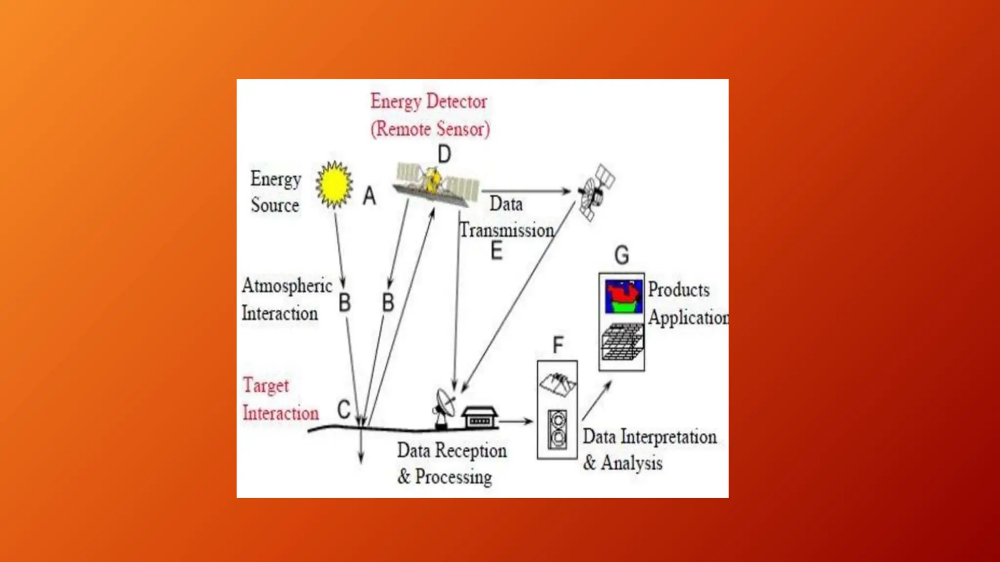
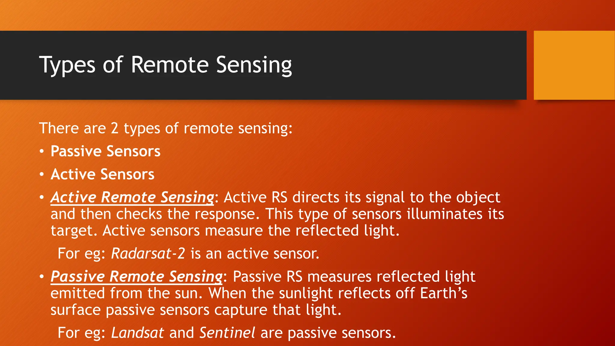
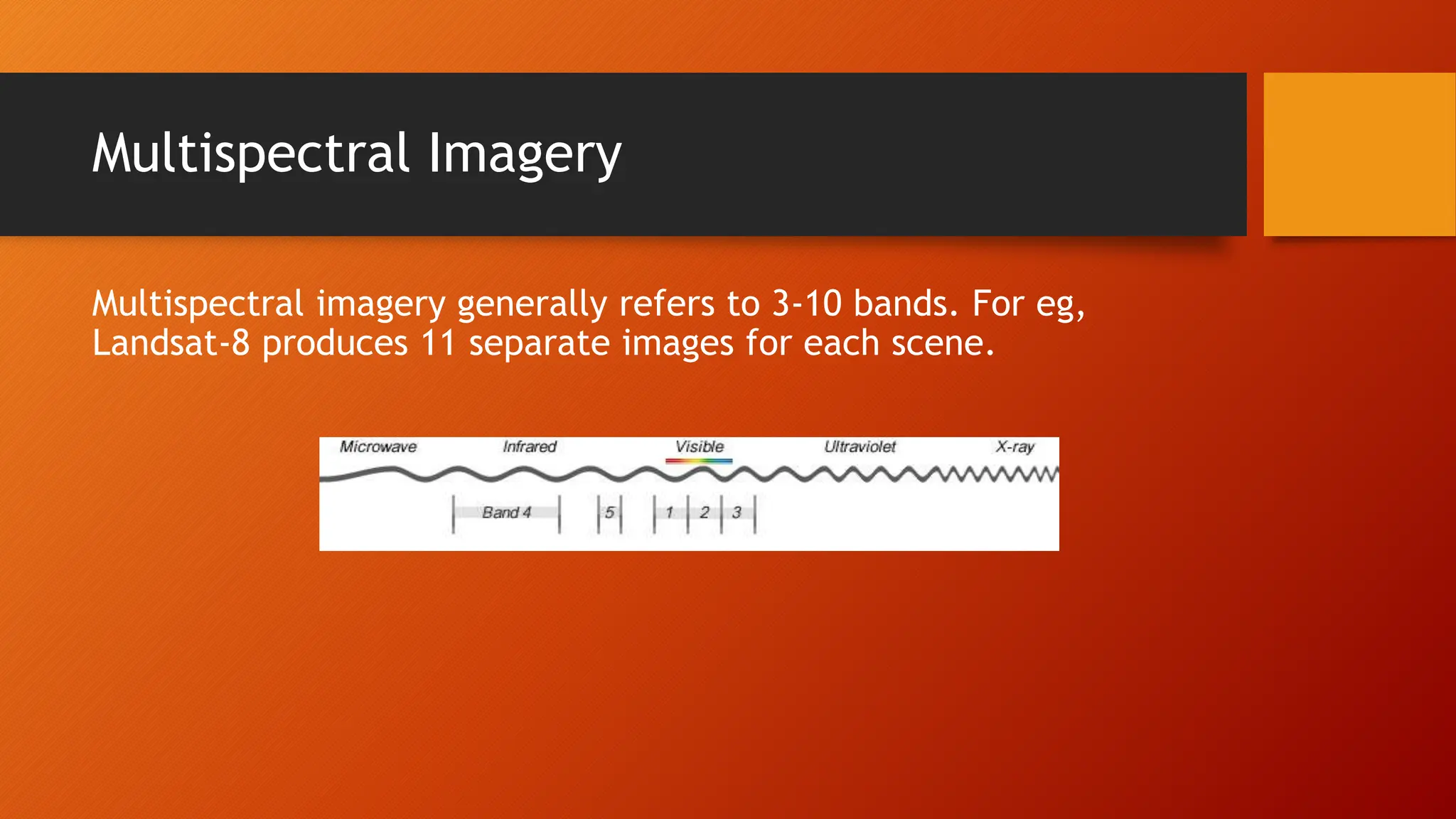
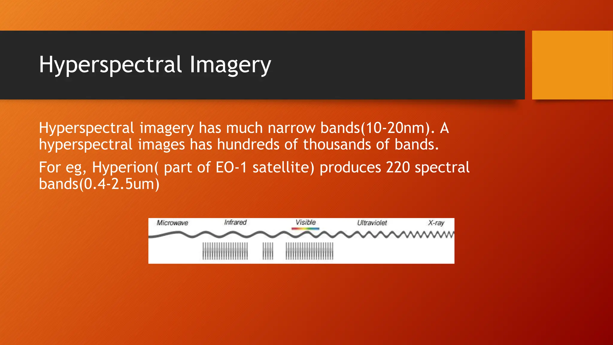
SlideShare a Scribd company logo
1 of 19
Remote Sensing And Its
Application
By-Binita Yadav
CONTENT:
• Remote sensing
• Basic components of Remote Sensing
• Types of Remote Sensing
• Spectral Bands
• GIS
• Application of Remote Sensing
• References
What is Remote Sensing?
Remote sensing is the securing of data about an object or
phenomenon without connecting with the object. Remote sensing is
utilized in various fields like topography, hydrology, environment,
oceanography and many more.
Conventionally remote sensing deals with the usenof light, i.e.,
electromagnetic radiation as the medium of interactions. RS refers
to the identification of earth features by detecting the characterist-
ics electromagnetic radiation that is reflected from the earth’s
surface.
Basic Components of Remote Sensing
• Energy source or Illumination: It is the first requirements of
remote sensing. It illuminates or provides electromagnetic energy
to the target of interest.
• Radiation and the Atmosphere: As the energy travels from its
source to the target, it will come in contact with and interact
with the atmosphere it passes through. This interaction may take
place a second time as the energy travels from the target to the
sensor.
• Interaction with the Target: Once the energy makes its way to the
target through the atmosphere, it interacts with the target
depending on the properties of both the target and the radiation.
• Recording of Energy by the sensor: After the energy has been
scattered by or emitted from the target, a sensor is required to
collect and record the electromagnetic radiation.
• Transmission, Reception, and Processing: The energy recorded by
the sensor has to be transmitted, often in electronic form,to a
receiving and processing station where the data are processed into
an image.
• Interpretation and Analysis: The processed image is interpreted,
visually and or digitally or electronically to extract information
about the target which was illuminated.
• Application: The final element of the remote sensing process is
achieved when the information extracted from the imagery about
the target is applied in order to better understand it. Ir reveals
some new information or assist in solving a particular problem.
Types of Remote Sensing
There are 2 types of remote sensing:
• Passive Sensors
• Active Sensors
• Active Remote Sensing: Active RS directs its signal to the object
and then checks the response. This type of sensors illuminates its
target. Active sensors measure the reflected light.
For eg: Radarsat-2 is an active sensor.
• Passive Remote Sensing: Passive RS measures reflected light
emitted from the sun. When the sunlight reflects off Earth’s
surface passive sensors capture that light.
For eg: Landsat and Sentinel are passive sensors.
Active Remote sensing Instrument
• Radar: It is a sensor assisting in ranging with radio signals. Its
specific feature is the antenna emiting impulses. Based on energy
amount and travelling time, its possible to estimate how far the
target is.
• Lidar: It determines distance with light. Lidar active remote
sensing implies transmitting light impulses and checking the
quantity retrieved. The target location and distance are measured
by multiplying the time by the speed of light.
The Electromagnetic Spectrum
The electromagnetic spectrum ranges from short wavelength (like
X-rays) to long wavelength (like radio waves). Human eyes can
possibly see the visible ranges of light(red, green, blue). But sensors
can see beyond human visible ranges. Hence RS is so powerful.
Human eyes can see spectrum ranges 390-700nm. Sensors were
design to capture beyond this wavelengths in the atmospheric
window.
For eg: Near infrared(NIR) is in the 700-1400nm ranges. Vegetation
reflects more green light because that’s how human eyes see it. But
its even more sensitive to near infrared. That’s why indexes like
NDVI is used to classify vegetation.
Passive Remote Sensing Instruments
• Spectometer: It distinguishes and analyzes spectral bands.
• Radiometers: Determines the power of radiation emitted by the
objects in particular band ranges(visible, IR, microwave)
Spectral Bands
Spectral bands are groups of wavelengths. For eg: Ultraviolet,
visible, near-infrared, thermal infrared and microwave are spectral
bands.
Spectral regions are categorized based on its frequency(v) or
wavelength. There are two types of imagery for passive sensors:
• Multispectral imagery
• Hyperspectral imagery
Multispectral Imagery
Multispectral imagery generally refers to 3-10 bands. For eg,
Landsat-8 produces 11 separate images for each scene.
Hyperspectral Imagery
Hyperspectral imagery has much narrow bands(10-20nm). A
hyperspectral images has hundreds of thousands of bands.
For eg, Hyperion( part of EO-1 satellite) produces 220 spectral
bands(0.4-2.5um)
Geographic Information System:
GIS is a combination of hardware and software that enables the
collection of data from different sources(remote sensing being one
of them). It relates spatial/tabular data, performs spatial/tabular
analysis and designs the layout of a map. In other words, GIS is a
computer assisted system that can input, store, retrieve, analyse
and display geographically referenced information useful for
decision making. The definition of GIS is not that important, but it
must encompass
• Data and concepts concerned with spatial distribution
(Geographical)
• Notion of conveying data, ideas or analysis(Information)
• The sequence of inputs, process and outputs(System)
Application of Remote sensing
• Agriculture: Agriculture plays a dominant role in the economics of both
developed and underdeveloped countries. Mapping tool such as satellite and
airborne images are used to classify crops, examine their health, examine
their viability and monitoring farming practices. Remote sensing application
in agriculture includes crop type classification, crop condition assessment,
crop yields estimation, mapping of soil characteristics, mapping of soil
management practices, and compliance monitoring.
• Forestry: Forest are a source of valuable resources for providing food,
shelter, wild life habitant, fuel and many daily supplies like medicinal
plants. Application of remote sensing in forestry include :
• Reconnaissance mapping: It helps in monitoring depletion and measuring
bio physical properties of forest stands.
• Commercial forestry : Remote sensing in commercial forestry helps in
collecting harvest information, updating inventory information for timber
supply, broad forest type, vegetation density, bio mass measurement
• Environmental monitoring: Conservation authorities are concerned with
monitoring the quantity, health and diversity of earths forest
• Geology: Geological application of remote sensing include the following :bad
rock mapping, lithogical mapping, structural mapping, sand and gravel
exploration, mineral exploration, hydrocarbon exploration, environmental
geology, sedimentation monitoring and planetary monitoring
• Fisheries: Remote sensing in fisheries provide spatial data on suspended
sediments, dissolve organic matters, phytoplankton, algalblooms and oil slicks
which are useful in management of fish stocks, monitor the water quality and
natural water pollution such as oil spill or algalbloom which are harmful to
aquatic life
• Remote sensing is very useful in identifying Potential Fishing zones(PFZ). This
data is very useful for fisher man because they came to know likely occurrence
of fish sholals which help them for getting more catch
References:
• https://eos.com/blog/types-of-remote-sensing/
• https://www.toppr.com/guides/physics/earth/remote-sensing/
• https://tudip.com/blog-post/what-is-remote-sensing-and-its-
applications/
THANK YOU

More Related Content

Similar to Application of Remote Sensing And GIS ..

Basic Concepts of Remote Sensing
Basic Concepts of Remote Sensing Basic Concepts of Remote Sensing
Basic Concepts of Remote Sensing Somenath Goswami
 
passive and active remote sensing systems, characteristics and operations
passive and active remote sensing systems,  characteristics and operationspassive and active remote sensing systems,  characteristics and operations
passive and active remote sensing systems, characteristics and operationsNzar Braim
 
Optical and infrared remote sensing
Optical and infrared remote sensingOptical and infrared remote sensing
Optical and infrared remote sensingNeha Sharma
 
Remote Sensing: Meaning, Concept and Components | Geography
Remote Sensing: Meaning, Concept and Components | GeographyRemote Sensing: Meaning, Concept and Components | Geography
Remote Sensing: Meaning, Concept and Components | GeographySrimantaKarak
 
A Brief Introduction to Remote Sensing Satellites
A Brief Introduction to Remote Sensing Satellites A Brief Introduction to Remote Sensing Satellites
A Brief Introduction to Remote Sensing Satellites Alireza Rahimzadeganasl
 
remote sensing for study.docx
remote sensing for study.docxremote sensing for study.docx
remote sensing for study.docxbbc37142
 
Remote sensing technology and applications
Remote  sensing technology and applicationsRemote  sensing technology and applications
Remote sensing technology and applicationsShyam Sundar Roy
 
Unit 1 introduction to remote sensing
Unit  1 introduction to remote sensing Unit  1 introduction to remote sensing
Unit 1 introduction to remote sensing Dhanalakshmi Dasari
 
remotesensing-150904070146-lva1-app6892.pdf
remotesensing-150904070146-lva1-app6892.pdfremotesensing-150904070146-lva1-app6892.pdf
remotesensing-150904070146-lva1-app6892.pdfBSuresh26
 
Remote sensing
Remote sensingRemote sensing
Remote sensingImran Syed
 
35001320006_Saraswati Mahato_Remote sensing and gis_ca 1_2024_even.pdf
35001320006_Saraswati Mahato_Remote sensing and gis_ca 1_2024_even.pdf35001320006_Saraswati Mahato_Remote sensing and gis_ca 1_2024_even.pdf
35001320006_Saraswati Mahato_Remote sensing and gis_ca 1_2024_even.pdfbarunmahato3
 
Remote sensing and tunneling.pptx
Remote sensing and tunneling.pptxRemote sensing and tunneling.pptx
Remote sensing and tunneling.pptxpandieswarim1
 

Similar to Application of Remote Sensing And GIS .. (20)

Remote sensing
Remote sensingRemote sensing
Remote sensing
 
remote sensing
remote sensingremote sensing
remote sensing
 
Ch 5 b remote sensing
Ch 5 b remote sensingCh 5 b remote sensing
Ch 5 b remote sensing
 
MAPPING REMOTE PLANTS THROUGH REMOTE SENSING TECHNOLOGY AND GIS
MAPPING REMOTE PLANTS THROUGH REMOTE SENSING TECHNOLOGY AND GISMAPPING REMOTE PLANTS THROUGH REMOTE SENSING TECHNOLOGY AND GIS
MAPPING REMOTE PLANTS THROUGH REMOTE SENSING TECHNOLOGY AND GIS
 
Remote sensing
Remote sensingRemote sensing
Remote sensing
 
Basic Concepts of Remote Sensing
Basic Concepts of Remote Sensing Basic Concepts of Remote Sensing
Basic Concepts of Remote Sensing
 
passive and active remote sensing systems, characteristics and operations
passive and active remote sensing systems,  characteristics and operationspassive and active remote sensing systems,  characteristics and operations
passive and active remote sensing systems, characteristics and operations
 
Optical and infrared remote sensing
Optical and infrared remote sensingOptical and infrared remote sensing
Optical and infrared remote sensing
 
Remote Sensing: Meaning, Concept and Components | Geography
Remote Sensing: Meaning, Concept and Components | GeographyRemote Sensing: Meaning, Concept and Components | Geography
Remote Sensing: Meaning, Concept and Components | Geography
 
A Brief Introduction to Remote Sensing Satellites
A Brief Introduction to Remote Sensing Satellites A Brief Introduction to Remote Sensing Satellites
A Brief Introduction to Remote Sensing Satellites
 
Remote sensing
Remote sensingRemote sensing
Remote sensing
 
RS_GIS_GPS.pdf
RS_GIS_GPS.pdfRS_GIS_GPS.pdf
RS_GIS_GPS.pdf
 
remote sensing for study.docx
remote sensing for study.docxremote sensing for study.docx
remote sensing for study.docx
 
Remote sensing technology and applications
Remote  sensing technology and applicationsRemote  sensing technology and applications
Remote sensing technology and applications
 
Remote sensing
Remote sensingRemote sensing
Remote sensing
 
Unit 1 introduction to remote sensing
Unit  1 introduction to remote sensing Unit  1 introduction to remote sensing
Unit 1 introduction to remote sensing
 
remotesensing-150904070146-lva1-app6892.pdf
remotesensing-150904070146-lva1-app6892.pdfremotesensing-150904070146-lva1-app6892.pdf
remotesensing-150904070146-lva1-app6892.pdf
 
Remote sensing
Remote sensingRemote sensing
Remote sensing
 
35001320006_Saraswati Mahato_Remote sensing and gis_ca 1_2024_even.pdf
35001320006_Saraswati Mahato_Remote sensing and gis_ca 1_2024_even.pdf35001320006_Saraswati Mahato_Remote sensing and gis_ca 1_2024_even.pdf
35001320006_Saraswati Mahato_Remote sensing and gis_ca 1_2024_even.pdf
 
Remote sensing and tunneling.pptx
Remote sensing and tunneling.pptxRemote sensing and tunneling.pptx
Remote sensing and tunneling.pptx
 

Recently uploaded

Call Girls in Mayapuri Delhi 💯Call Us 🔝9953322196🔝 💯Escort.
Call Girls in Mayapuri Delhi 💯Call Us 🔝9953322196🔝 💯Escort.Call Girls in Mayapuri Delhi 💯Call Us 🔝9953322196🔝 💯Escort.
Call Girls in Mayapuri Delhi 💯Call Us 🔝9953322196🔝 💯Escort.aasikanpl
 
Analytical Profile of Coleus Forskohlii | Forskolin .pptx
Analytical Profile of Coleus Forskohlii | Forskolin .pptxAnalytical Profile of Coleus Forskohlii | Forskolin .pptx
Analytical Profile of Coleus Forskohlii | Forskolin .pptxSwapnil Therkar
 
Animal Communication- Auditory and Visual.pptx
Animal Communication- Auditory and Visual.pptxAnimal Communication- Auditory and Visual.pptx
Animal Communication- Auditory and Visual.pptxUmerFayaz5
 
Disentangling the origin of chemical differences using GHOST
Disentangling the origin of chemical differences using GHOSTDisentangling the origin of chemical differences using GHOST
Disentangling the origin of chemical differences using GHOSTSérgio Sacani
 
Scheme-of-Work-Science-Stage-4 cambridge science.docx
Scheme-of-Work-Science-Stage-4 cambridge science.docxScheme-of-Work-Science-Stage-4 cambridge science.docx
Scheme-of-Work-Science-Stage-4 cambridge science.docxyaramohamed343013
 
Nanoparticles synthesis and characterization​ ​
Nanoparticles synthesis and characterization​  ​Nanoparticles synthesis and characterization​  ​
Nanoparticles synthesis and characterization​ ​kaibalyasahoo82800
 
Artificial Intelligence In Microbiology by Dr. Prince C P
Artificial Intelligence In Microbiology by Dr. Prince C PArtificial Intelligence In Microbiology by Dr. Prince C P
Artificial Intelligence In Microbiology by Dr. Prince C PPRINCE C P
 
Behavioral Disorder: Schizophrenia & it's Case Study.pdf
Behavioral Disorder: Schizophrenia & it's Case Study.pdfBehavioral Disorder: Schizophrenia & it's Case Study.pdf
Behavioral Disorder: Schizophrenia & it's Case Study.pdfSELF-EXPLANATORY
 
Biopesticide (2).pptx .This slides helps to know the different types of biop...
Biopesticide (2).pptx  .This slides helps to know the different types of biop...Biopesticide (2).pptx  .This slides helps to know the different types of biop...
Biopesticide (2).pptx .This slides helps to know the different types of biop...RohitNehra6
 
Natural Polymer Based Nanomaterials
Natural Polymer Based NanomaterialsNatural Polymer Based Nanomaterials
Natural Polymer Based NanomaterialsAArockiyaNisha
 
Unlocking the Potential: Deep dive into ocean of Ceramic Magnets.pptx
Unlocking  the Potential: Deep dive into ocean of Ceramic Magnets.pptxUnlocking  the Potential: Deep dive into ocean of Ceramic Magnets.pptx
Unlocking the Potential: Deep dive into ocean of Ceramic Magnets.pptxanandsmhk
 
Physiochemical properties of nanomaterials and its nanotoxicity.pptx
Physiochemical properties of nanomaterials and its nanotoxicity.pptxPhysiochemical properties of nanomaterials and its nanotoxicity.pptx
Physiochemical properties of nanomaterials and its nanotoxicity.pptxAArockiyaNisha
 
Call Girls in Munirka Delhi 💯Call Us 🔝9953322196🔝 💯Escort.
Call Girls in Munirka Delhi 💯Call Us 🔝9953322196🔝 💯Escort.Call Girls in Munirka Delhi 💯Call Us 🔝9953322196🔝 💯Escort.
Call Girls in Munirka Delhi 💯Call Us 🔝9953322196🔝 💯Escort.aasikanpl
 
Recombination DNA Technology (Nucleic Acid Hybridization )
Recombination DNA Technology (Nucleic Acid Hybridization )Recombination DNA Technology (Nucleic Acid Hybridization )
Recombination DNA Technology (Nucleic Acid Hybridization )aarthirajkumar25
 
STERILITY TESTING OF PHARMACEUTICALS ppt by DR.C.P.PRINCE
STERILITY TESTING OF PHARMACEUTICALS ppt by DR.C.P.PRINCESTERILITY TESTING OF PHARMACEUTICALS ppt by DR.C.P.PRINCE
STERILITY TESTING OF PHARMACEUTICALS ppt by DR.C.P.PRINCEPRINCE C P
 
Spermiogenesis or Spermateleosis or metamorphosis of spermatid
Spermiogenesis or Spermateleosis or metamorphosis of spermatidSpermiogenesis or Spermateleosis or metamorphosis of spermatid
Spermiogenesis or Spermateleosis or metamorphosis of spermatidSarthak Sekhar Mondal
 
Is RISC-V ready for HPC workload? Maybe?
Is RISC-V ready for HPC workload? Maybe?Is RISC-V ready for HPC workload? Maybe?
Is RISC-V ready for HPC workload? Maybe?Patrick Diehl
 
Stunning ➥8448380779▻ Call Girls In Panchshil Enclave Delhi NCR
Stunning ➥8448380779▻ Call Girls In Panchshil Enclave Delhi NCRStunning ➥8448380779▻ Call Girls In Panchshil Enclave Delhi NCR
Stunning ➥8448380779▻ Call Girls In Panchshil Enclave Delhi NCRDelhi Call girls
 
Analytical Profile of Coleus Forskohlii | Forskolin .pdf
Analytical Profile of Coleus Forskohlii | Forskolin .pdfAnalytical Profile of Coleus Forskohlii | Forskolin .pdf
Analytical Profile of Coleus Forskohlii | Forskolin .pdfSwapnil Therkar
 

Recently uploaded (20)

Call Girls in Mayapuri Delhi 💯Call Us 🔝9953322196🔝 💯Escort.
Call Girls in Mayapuri Delhi 💯Call Us 🔝9953322196🔝 💯Escort.Call Girls in Mayapuri Delhi 💯Call Us 🔝9953322196🔝 💯Escort.
Call Girls in Mayapuri Delhi 💯Call Us 🔝9953322196🔝 💯Escort.
 
Analytical Profile of Coleus Forskohlii | Forskolin .pptx
Analytical Profile of Coleus Forskohlii | Forskolin .pptxAnalytical Profile of Coleus Forskohlii | Forskolin .pptx
Analytical Profile of Coleus Forskohlii | Forskolin .pptx
 
Animal Communication- Auditory and Visual.pptx
Animal Communication- Auditory and Visual.pptxAnimal Communication- Auditory and Visual.pptx
Animal Communication- Auditory and Visual.pptx
 
Disentangling the origin of chemical differences using GHOST
Disentangling the origin of chemical differences using GHOSTDisentangling the origin of chemical differences using GHOST
Disentangling the origin of chemical differences using GHOST
 
Scheme-of-Work-Science-Stage-4 cambridge science.docx
Scheme-of-Work-Science-Stage-4 cambridge science.docxScheme-of-Work-Science-Stage-4 cambridge science.docx
Scheme-of-Work-Science-Stage-4 cambridge science.docx
 
Nanoparticles synthesis and characterization​ ​
Nanoparticles synthesis and characterization​  ​Nanoparticles synthesis and characterization​  ​
Nanoparticles synthesis and characterization​ ​
 
9953056974 Young Call Girls In Mahavir enclave Indian Quality Escort service
9953056974 Young Call Girls In Mahavir enclave Indian Quality Escort service9953056974 Young Call Girls In Mahavir enclave Indian Quality Escort service
9953056974 Young Call Girls In Mahavir enclave Indian Quality Escort service
 
Artificial Intelligence In Microbiology by Dr. Prince C P
Artificial Intelligence In Microbiology by Dr. Prince C PArtificial Intelligence In Microbiology by Dr. Prince C P
Artificial Intelligence In Microbiology by Dr. Prince C P
 
Behavioral Disorder: Schizophrenia & it's Case Study.pdf
Behavioral Disorder: Schizophrenia & it's Case Study.pdfBehavioral Disorder: Schizophrenia & it's Case Study.pdf
Behavioral Disorder: Schizophrenia & it's Case Study.pdf
 
Biopesticide (2).pptx .This slides helps to know the different types of biop...
Biopesticide (2).pptx  .This slides helps to know the different types of biop...Biopesticide (2).pptx  .This slides helps to know the different types of biop...
Biopesticide (2).pptx .This slides helps to know the different types of biop...
 
Natural Polymer Based Nanomaterials
Natural Polymer Based NanomaterialsNatural Polymer Based Nanomaterials
Natural Polymer Based Nanomaterials
 
Unlocking the Potential: Deep dive into ocean of Ceramic Magnets.pptx
Unlocking  the Potential: Deep dive into ocean of Ceramic Magnets.pptxUnlocking  the Potential: Deep dive into ocean of Ceramic Magnets.pptx
Unlocking the Potential: Deep dive into ocean of Ceramic Magnets.pptx
 
Physiochemical properties of nanomaterials and its nanotoxicity.pptx
Physiochemical properties of nanomaterials and its nanotoxicity.pptxPhysiochemical properties of nanomaterials and its nanotoxicity.pptx
Physiochemical properties of nanomaterials and its nanotoxicity.pptx
 
Call Girls in Munirka Delhi 💯Call Us 🔝9953322196🔝 💯Escort.
Call Girls in Munirka Delhi 💯Call Us 🔝9953322196🔝 💯Escort.Call Girls in Munirka Delhi 💯Call Us 🔝9953322196🔝 💯Escort.
Call Girls in Munirka Delhi 💯Call Us 🔝9953322196🔝 💯Escort.
 
Recombination DNA Technology (Nucleic Acid Hybridization )
Recombination DNA Technology (Nucleic Acid Hybridization )Recombination DNA Technology (Nucleic Acid Hybridization )
Recombination DNA Technology (Nucleic Acid Hybridization )
 
STERILITY TESTING OF PHARMACEUTICALS ppt by DR.C.P.PRINCE
STERILITY TESTING OF PHARMACEUTICALS ppt by DR.C.P.PRINCESTERILITY TESTING OF PHARMACEUTICALS ppt by DR.C.P.PRINCE
STERILITY TESTING OF PHARMACEUTICALS ppt by DR.C.P.PRINCE
 
Spermiogenesis or Spermateleosis or metamorphosis of spermatid
Spermiogenesis or Spermateleosis or metamorphosis of spermatidSpermiogenesis or Spermateleosis or metamorphosis of spermatid
Spermiogenesis or Spermateleosis or metamorphosis of spermatid
 
Is RISC-V ready for HPC workload? Maybe?
Is RISC-V ready for HPC workload? Maybe?Is RISC-V ready for HPC workload? Maybe?
Is RISC-V ready for HPC workload? Maybe?
 
Stunning ➥8448380779▻ Call Girls In Panchshil Enclave Delhi NCR
Stunning ➥8448380779▻ Call Girls In Panchshil Enclave Delhi NCRStunning ➥8448380779▻ Call Girls In Panchshil Enclave Delhi NCR
Stunning ➥8448380779▻ Call Girls In Panchshil Enclave Delhi NCR
 
Analytical Profile of Coleus Forskohlii | Forskolin .pdf
Analytical Profile of Coleus Forskohlii | Forskolin .pdfAnalytical Profile of Coleus Forskohlii | Forskolin .pdf
Analytical Profile of Coleus Forskohlii | Forskolin .pdf
 

Application of Remote Sensing And GIS ..

  • 1. Remote Sensing And Its Application By-Binita Yadav
  • 2. CONTENT: • Remote sensing • Basic components of Remote Sensing • Types of Remote Sensing • Spectral Bands • GIS • Application of Remote Sensing • References
  • 3. What is Remote Sensing? Remote sensing is the securing of data about an object or phenomenon without connecting with the object. Remote sensing is utilized in various fields like topography, hydrology, environment, oceanography and many more. Conventionally remote sensing deals with the usenof light, i.e., electromagnetic radiation as the medium of interactions. RS refers to the identification of earth features by detecting the characterist- ics electromagnetic radiation that is reflected from the earth’s surface.
  • 4. Basic Components of Remote Sensing • Energy source or Illumination: It is the first requirements of remote sensing. It illuminates or provides electromagnetic energy to the target of interest. • Radiation and the Atmosphere: As the energy travels from its source to the target, it will come in contact with and interact with the atmosphere it passes through. This interaction may take place a second time as the energy travels from the target to the sensor. • Interaction with the Target: Once the energy makes its way to the target through the atmosphere, it interacts with the target depending on the properties of both the target and the radiation.
  • 5. • Recording of Energy by the sensor: After the energy has been scattered by or emitted from the target, a sensor is required to collect and record the electromagnetic radiation. • Transmission, Reception, and Processing: The energy recorded by the sensor has to be transmitted, often in electronic form,to a receiving and processing station where the data are processed into an image. • Interpretation and Analysis: The processed image is interpreted, visually and or digitally or electronically to extract information about the target which was illuminated. • Application: The final element of the remote sensing process is achieved when the information extracted from the imagery about the target is applied in order to better understand it. Ir reveals some new information or assist in solving a particular problem.
  • 6.
  • 7. Types of Remote Sensing There are 2 types of remote sensing: • Passive Sensors • Active Sensors • Active Remote Sensing: Active RS directs its signal to the object and then checks the response. This type of sensors illuminates its target. Active sensors measure the reflected light. For eg: Radarsat-2 is an active sensor. • Passive Remote Sensing: Passive RS measures reflected light emitted from the sun. When the sunlight reflects off Earth’s surface passive sensors capture that light. For eg: Landsat and Sentinel are passive sensors.
  • 8. Active Remote sensing Instrument • Radar: It is a sensor assisting in ranging with radio signals. Its specific feature is the antenna emiting impulses. Based on energy amount and travelling time, its possible to estimate how far the target is. • Lidar: It determines distance with light. Lidar active remote sensing implies transmitting light impulses and checking the quantity retrieved. The target location and distance are measured by multiplying the time by the speed of light.
  • 9. The Electromagnetic Spectrum The electromagnetic spectrum ranges from short wavelength (like X-rays) to long wavelength (like radio waves). Human eyes can possibly see the visible ranges of light(red, green, blue). But sensors can see beyond human visible ranges. Hence RS is so powerful. Human eyes can see spectrum ranges 390-700nm. Sensors were design to capture beyond this wavelengths in the atmospheric window. For eg: Near infrared(NIR) is in the 700-1400nm ranges. Vegetation reflects more green light because that’s how human eyes see it. But its even more sensitive to near infrared. That’s why indexes like NDVI is used to classify vegetation.
  • 10. Passive Remote Sensing Instruments • Spectometer: It distinguishes and analyzes spectral bands. • Radiometers: Determines the power of radiation emitted by the objects in particular band ranges(visible, IR, microwave)
  • 11.
  • 12. Spectral Bands Spectral bands are groups of wavelengths. For eg: Ultraviolet, visible, near-infrared, thermal infrared and microwave are spectral bands. Spectral regions are categorized based on its frequency(v) or wavelength. There are two types of imagery for passive sensors: • Multispectral imagery • Hyperspectral imagery
  • 13. Multispectral Imagery Multispectral imagery generally refers to 3-10 bands. For eg, Landsat-8 produces 11 separate images for each scene.
  • 14. Hyperspectral Imagery Hyperspectral imagery has much narrow bands(10-20nm). A hyperspectral images has hundreds of thousands of bands. For eg, Hyperion( part of EO-1 satellite) produces 220 spectral bands(0.4-2.5um)
  • 15. Geographic Information System: GIS is a combination of hardware and software that enables the collection of data from different sources(remote sensing being one of them). It relates spatial/tabular data, performs spatial/tabular analysis and designs the layout of a map. In other words, GIS is a computer assisted system that can input, store, retrieve, analyse and display geographically referenced information useful for decision making. The definition of GIS is not that important, but it must encompass • Data and concepts concerned with spatial distribution (Geographical) • Notion of conveying data, ideas or analysis(Information) • The sequence of inputs, process and outputs(System)
  • 16. Application of Remote sensing • Agriculture: Agriculture plays a dominant role in the economics of both developed and underdeveloped countries. Mapping tool such as satellite and airborne images are used to classify crops, examine their health, examine their viability and monitoring farming practices. Remote sensing application in agriculture includes crop type classification, crop condition assessment, crop yields estimation, mapping of soil characteristics, mapping of soil management practices, and compliance monitoring. • Forestry: Forest are a source of valuable resources for providing food, shelter, wild life habitant, fuel and many daily supplies like medicinal plants. Application of remote sensing in forestry include : • Reconnaissance mapping: It helps in monitoring depletion and measuring bio physical properties of forest stands.
  • 17. • Commercial forestry : Remote sensing in commercial forestry helps in collecting harvest information, updating inventory information for timber supply, broad forest type, vegetation density, bio mass measurement • Environmental monitoring: Conservation authorities are concerned with monitoring the quantity, health and diversity of earths forest • Geology: Geological application of remote sensing include the following :bad rock mapping, lithogical mapping, structural mapping, sand and gravel exploration, mineral exploration, hydrocarbon exploration, environmental geology, sedimentation monitoring and planetary monitoring • Fisheries: Remote sensing in fisheries provide spatial data on suspended sediments, dissolve organic matters, phytoplankton, algalblooms and oil slicks which are useful in management of fish stocks, monitor the water quality and natural water pollution such as oil spill or algalbloom which are harmful to aquatic life • Remote sensing is very useful in identifying Potential Fishing zones(PFZ). This data is very useful for fisher man because they came to know likely occurrence of fish sholals which help them for getting more catch