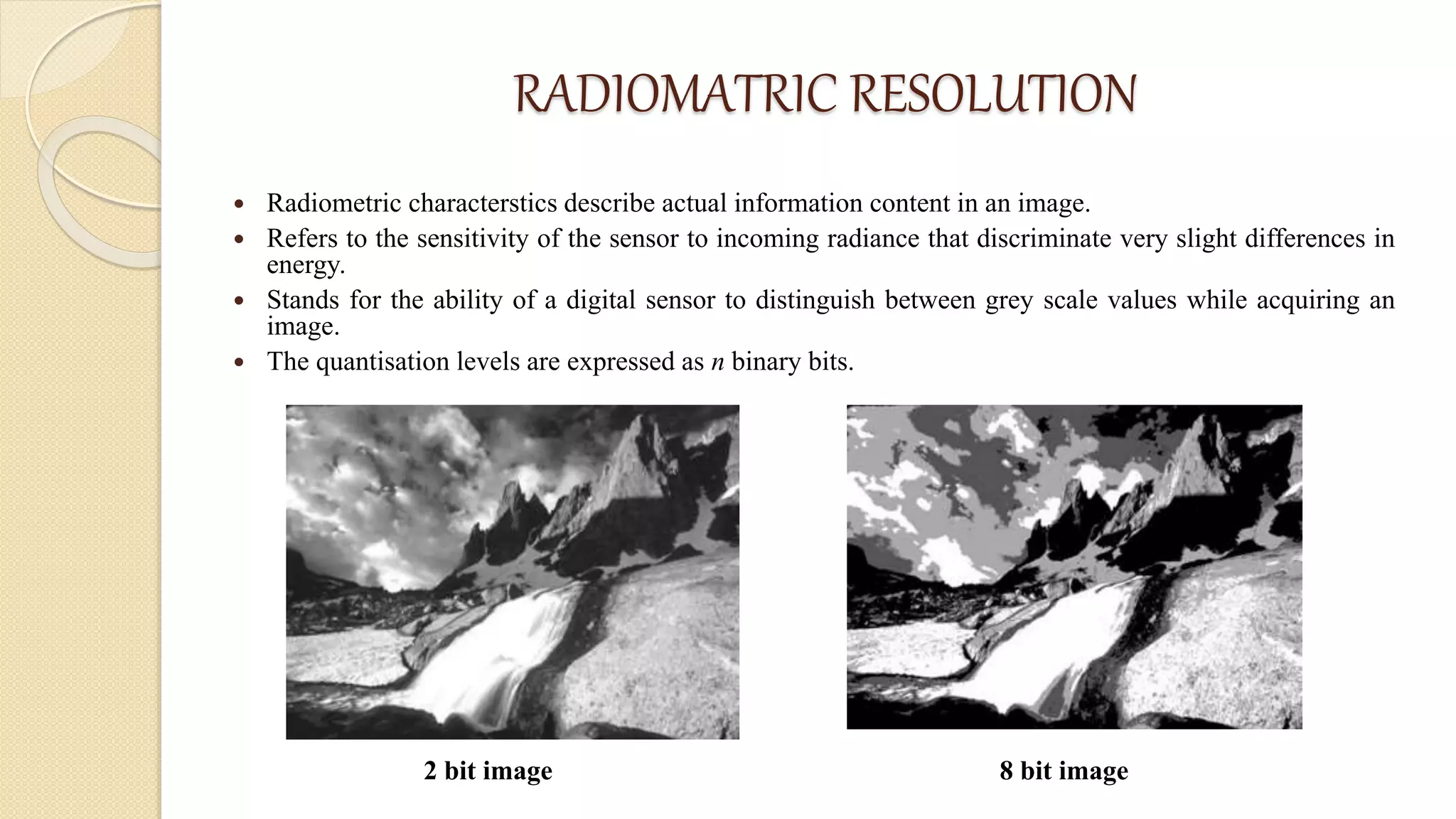
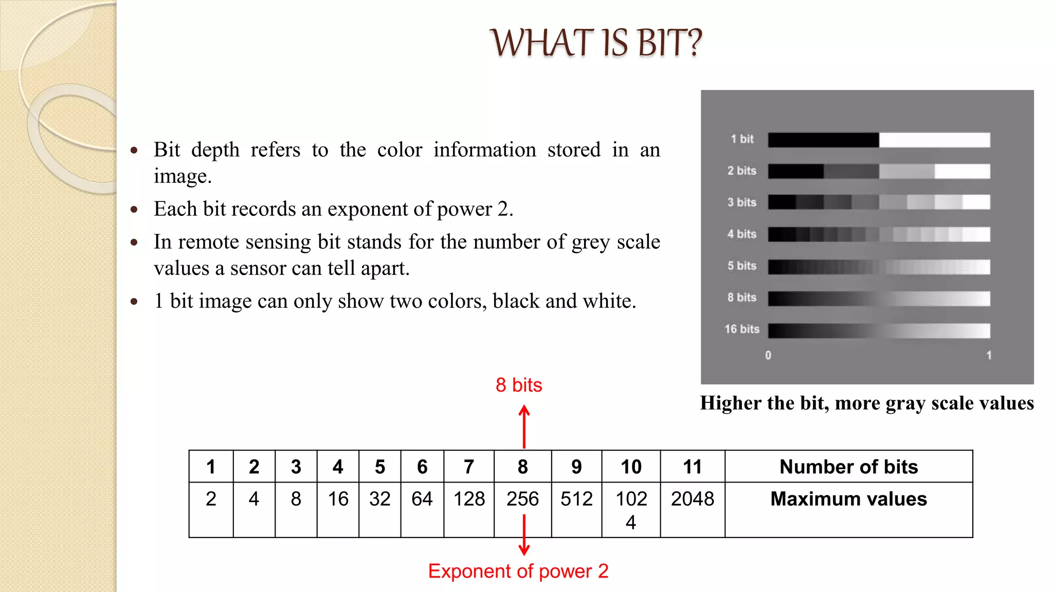
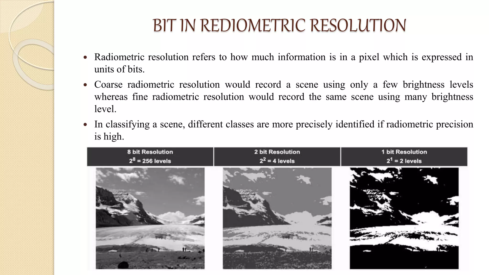
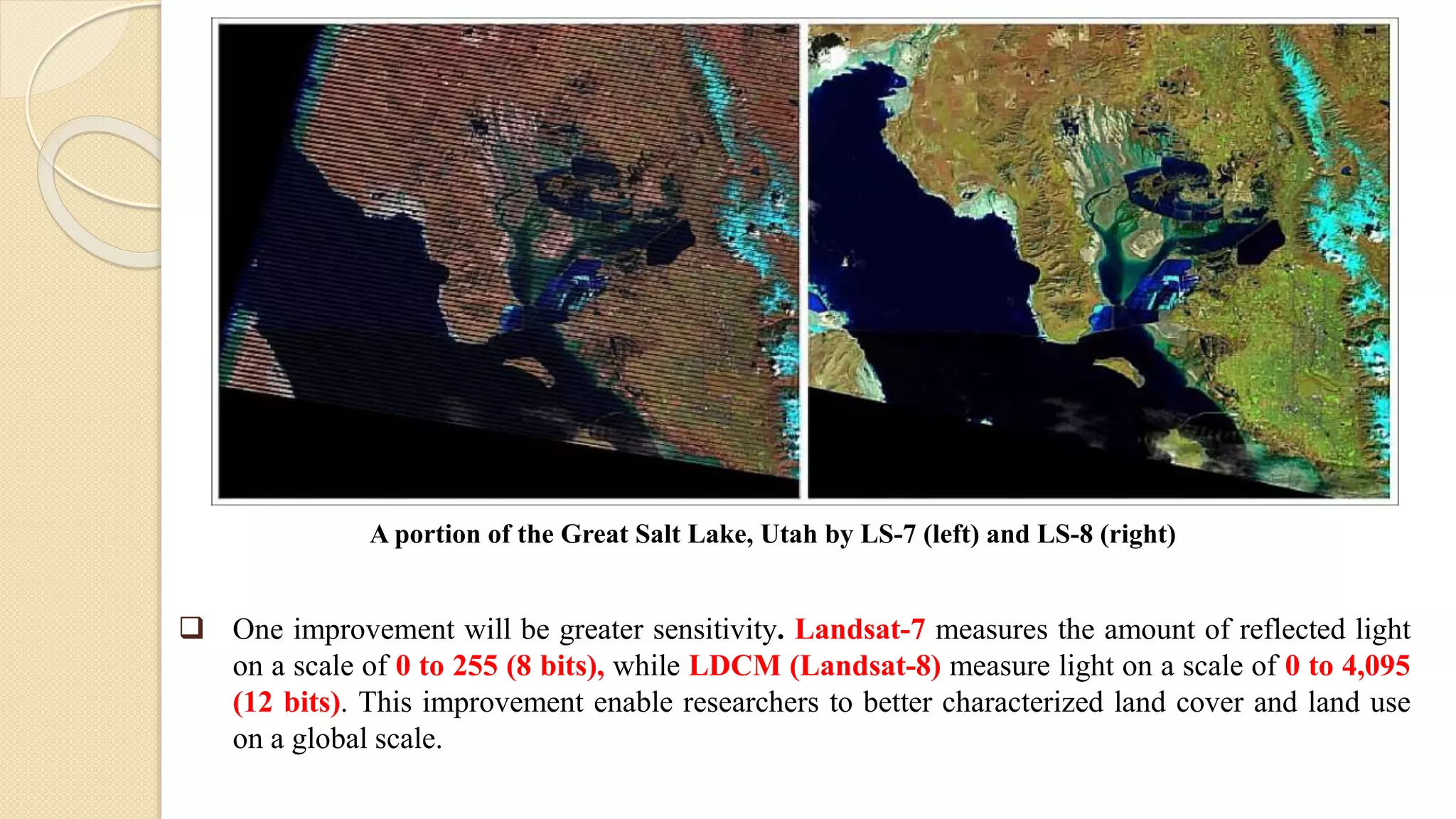
Radiometric resolution
ASSAM UNIVERSITY, SILCHAR
DEPARTMENT OF EARTH SCIENCE
PRESENTED BY:
KUKI MONJORI BORUAH
MSc. 1ST SEMESTER
ROLL NO-202112
SUBMITTED TO:
Dr. PURBOJYOTI PHUKON
ASSISTANT PROFESSOR
CONTENT
 INTRODUCTION
 RADIOMETRIC RESOLUTION
 BIT
 BIT IN RADIOMATRIC RESOLUTION
 APPLICATION OF RADIOMETRIC RESOLUTION
 CONCLUSION
 REFERENCES
INTRODUCTION
 Image resolution refers to the ability of a remote sensing system to record and display the
finer details including the quality of data.
 Resolution of a sensor system is its capability to discriminate two closely spaced objects
from each other.
 Varies from sensor to sensor and broadly described as coarse and fine.
 Categorized into four types-
 Spatial resolution (what area & how detailed)
 Spectral resolution (what color bands)
 Temporal resolution (time of day/season/year)
 Rediometric resolution (color depth)
RADIOMATRIC RESOLUTION
 Radiometric characterstics describe actual information content in an image.
 Refers to the sensitivity of the sensor to incoming radiance that discriminate very slight differences in
energy.
 Stands for the ability of a digital sensor to distinguish between grey scale values while acquiring an
image.
 The quantisation levels are expressed as n binary bits.
2 bit image 8 bit image
WHAT IS BIT?
 Bit depth refers to the color information stored in an
image.
 Each bit records an exponent of power 2.
 In remote sensing bit stands for the number of grey scale
values a sensor can tell apart.
 1 bit image can only show two colors, black and white.
1 2 3 4 5 6 7 8 9 10 11 Number of bits
2 4 8 16 32 64 128 256 512 102
4
2048 Maximum values
8 bits
Exponent of power 2
Higher the bit, more gray scale values
BIT IN REDIOMETRIC RESOLUTION
 Radiometric resolution refers to how much information is in a pixel which is expressed in
units of bits.
 Coarse radiometric resolution would record a scene using only a few brightness levels
whereas fine radiometric resolution would record the same scene using many brightness
level.
 In classifying a scene, different classes are more precisely identified if radiometric precision
is high.
APPLICATION OF RADIOMETRIC RESOLUTION
• A satellite perceives different wavelengths in different
intensities and can only distinguish between bright and
dark.
• A spectral image is not less than a raster consisting of
different grey-scale values.
• NASA Satellite sensor examples:
o 12 bit sensor (MODIS, MISR, LANDSAT-9
TM/MSS), 4096 levels
o 10 bit sensor (AVHRR), 1024 levels
o 8 bit sensor (LANDSAT-7 TM), 256 levels
o 6 bit sensor (LANDSAT-7 MSS), 64 levels
 One improvement will be greater sensitivity. Landsat-7 measures the amount of reflected light
on a scale of 0 to 255 (8 bits), while LDCM (Landsat-8) measure light on a scale of 0 to 4,095
(12 bits). This improvement enable researchers to better characterized land cover and land use
on a global scale.
A portion of the Great Salt Lake, Utah by LS-7 (left) and LS-8 (right)
CONCLUSION
 The radiometric resolution of image data in remote sensing stands for the
ability of the sensor to distinguish different grey-scale values.
 It is measured in bits.
 The more bit an image has the more grey-scale values can be stored and thus
more differences in the reflection on the land surface can be spotted.
REFERENCES
 Gupta, Ravi P.; 3rd edition; Remote Sensing Geology.
 https://egyankosh.ac.in/bitestream/123456789/39533/1/Unit-5.pdf
 https://appliedsciences.nasa.gov/sites/default/files/D1P3_Fundamentals.pdf
 https://www.coursera.org/lecture/spatial-analysis-satellite-imagery-in-a-
gis/radiometric-resolution-of-satellite-sensors-Y7pkP
RADIOMETRIC RESOLUTION.pptx

RADIOMETRIC RESOLUTION.pptx

  • 1.
    Radiometric resolution ASSAM UNIVERSITY,SILCHAR DEPARTMENT OF EARTH SCIENCE PRESENTED BY: KUKI MONJORI BORUAH MSc. 1ST SEMESTER ROLL NO-202112 SUBMITTED TO: Dr. PURBOJYOTI PHUKON ASSISTANT PROFESSOR
  • 2.
    CONTENT  INTRODUCTION  RADIOMETRICRESOLUTION  BIT  BIT IN RADIOMATRIC RESOLUTION  APPLICATION OF RADIOMETRIC RESOLUTION  CONCLUSION  REFERENCES
  • 3.
    INTRODUCTION  Image resolutionrefers to the ability of a remote sensing system to record and display the finer details including the quality of data.  Resolution of a sensor system is its capability to discriminate two closely spaced objects from each other.  Varies from sensor to sensor and broadly described as coarse and fine.  Categorized into four types-  Spatial resolution (what area & how detailed)  Spectral resolution (what color bands)  Temporal resolution (time of day/season/year)  Rediometric resolution (color depth)
  • 4.
    RADIOMATRIC RESOLUTION  Radiometriccharacterstics describe actual information content in an image.  Refers to the sensitivity of the sensor to incoming radiance that discriminate very slight differences in energy.  Stands for the ability of a digital sensor to distinguish between grey scale values while acquiring an image.  The quantisation levels are expressed as n binary bits. 2 bit image 8 bit image
  • 5.
    WHAT IS BIT? Bit depth refers to the color information stored in an image.  Each bit records an exponent of power 2.  In remote sensing bit stands for the number of grey scale values a sensor can tell apart.  1 bit image can only show two colors, black and white. 1 2 3 4 5 6 7 8 9 10 11 Number of bits 2 4 8 16 32 64 128 256 512 102 4 2048 Maximum values 8 bits Exponent of power 2 Higher the bit, more gray scale values
  • 6.
    BIT IN REDIOMETRICRESOLUTION  Radiometric resolution refers to how much information is in a pixel which is expressed in units of bits.  Coarse radiometric resolution would record a scene using only a few brightness levels whereas fine radiometric resolution would record the same scene using many brightness level.  In classifying a scene, different classes are more precisely identified if radiometric precision is high.
  • 7.
    APPLICATION OF RADIOMETRICRESOLUTION • A satellite perceives different wavelengths in different intensities and can only distinguish between bright and dark. • A spectral image is not less than a raster consisting of different grey-scale values. • NASA Satellite sensor examples: o 12 bit sensor (MODIS, MISR, LANDSAT-9 TM/MSS), 4096 levels o 10 bit sensor (AVHRR), 1024 levels o 8 bit sensor (LANDSAT-7 TM), 256 levels o 6 bit sensor (LANDSAT-7 MSS), 64 levels
  • 8.
     One improvementwill be greater sensitivity. Landsat-7 measures the amount of reflected light on a scale of 0 to 255 (8 bits), while LDCM (Landsat-8) measure light on a scale of 0 to 4,095 (12 bits). This improvement enable researchers to better characterized land cover and land use on a global scale. A portion of the Great Salt Lake, Utah by LS-7 (left) and LS-8 (right)
  • 9.
    CONCLUSION  The radiometricresolution of image data in remote sensing stands for the ability of the sensor to distinguish different grey-scale values.  It is measured in bits.  The more bit an image has the more grey-scale values can be stored and thus more differences in the reflection on the land surface can be spotted.
  • 10.
    REFERENCES  Gupta, RaviP.; 3rd edition; Remote Sensing Geology.  https://egyankosh.ac.in/bitestream/123456789/39533/1/Unit-5.pdf  https://appliedsciences.nasa.gov/sites/default/files/D1P3_Fundamentals.pdf  https://www.coursera.org/lecture/spatial-analysis-satellite-imagery-in-a- gis/radiometric-resolution-of-satellite-sensors-Y7pkP