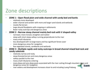
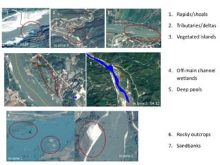
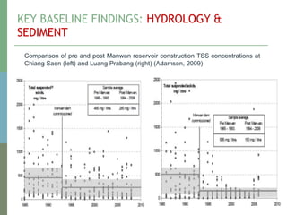
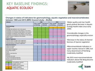
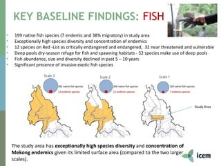
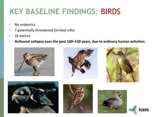
1) The document summarizes key baseline findings from an environmental study of the Lancang-Mekong River, including descriptions of three zones along the river with differing geomorphological characteristics.
2) Major findings include the identification of deep pools that are dry season fish habitats, changes to hydrology and sediment levels from Chinese dams, declines in the status of aquatic ecology indicators, and high fish diversity including endangered species that use deep pools.
3) Key drivers of environmental changes in the region include dams in the upper Mekong, land use changes, development activities, and increased pressures from activities like fishing, hunting, and agriculture.
FULL ENJOY Call Girls In kashmiri gate (Delhi) Call Us 9953056974
Lancang-Mekong Development Plan Findings
1. Final Workshop: 10 December 2018, MRC, Vientiane
Peter-John Meynell
Environmental Study of the
Lancang-Mekong Development Plan
Baseline assessment findings – key issues, trends and
drivers
2.
3. Zone descriptions
• ZONE 1 - Open flood plain and wide channel with sandy bed and banks
– relatively more developed
– wider channel and sandier with more and larger sand islands and wetlands
– mostly flat terrain
– large alluvial floodplains with cropping or settlements
– fewer rocky outcrops and dangerous areas
• ZONE 2 - Narrow steep channel mainly bed rock with V shaped valley
– narrower, more incised, straighter and rockier
– steep with short steep valleys running perpendicular to the river
– many small tributaries
– less developed with no large towns and has significant forest cover
– more dangerous areas for navigation
– few vegetated islands, sandbanks and wetlands
• ZONE 3 - Multiple rapids and rocky outcrops in broad channel mixed bed rock and
sandy substrate
– relatively narrow and rocky
– steep forested terrain and many dangerous areas
– valleys parallel to the river
– many small tributaries entering
– many deep and very deep pools associated with the river cutting through mountain ridges and
dangerous areas for navigation
– river widens and development increases closer to and including Luang Prabang
6. A ‘fly over’ of the target Mekong River
PJ to show Google Earth Fly-over
7. KEY BASELINE FINDINGS: BATHYMETRIC
SURVEY (SWIM UNDER)
7
• Deep pools: dry-season refuge for fish; spawning habitats
• 52 fish species known to make use of deep pools
• 19 deep (5 – 20m) and 10 very deep (up to 90m) pools
• Each pool - 10 to 15 ha
• Very deep pools concentrated between Pak Beng dam site
and Pak Ou
8. KEY BASELINE FINDINGS: HYDROLOGY &
SEDIMENT
• Increase in dry season flows, decrease in wet season flows due to China
dams
• Significant reduction in suspended sediment concentrations at Chiang Saen
after 1992 dams
• Land use changes - some evidence of increased sediment loads due to
tributary contributions in study zone with implications for reservoir
9. KEY BASELINE FINDINGS: HYDROLOGY &
SEDIMENT
Percentage of average flow originating in each countryduring
wet – June to November (left – 55% from China in study area)
dry – December to May (right – 75% from China in study area).
The study section is indicated by the red arrows
MRC 2005
10. KEY BASELINE FINDINGS: HYDROLOGY &
SEDIMENT
Comparison of pre and post Manwan reservoir construction TSS concentrations at
Chiang Saen (left) and Luang Prabang (right) (Adamson, 2009)
11. KEY BASELINE FINDINGS:
AQUATIC ECOLOGY
Changes in status of indicators for geomorphology, aquatic vegetation and macroinvertebrates
between 1985 and 2015 (MRC Council study – BioRa)
•Water quality and river health
good; gradual decrease in Aquatic
Ecology Health Index since early
2000s
•Considerable changes in the
geomorphology, especially erosion
•Decrease in the status of channel
biomass of riparian vegetation
•Macroinvertebrate indicators in
upper reaches natural in 1985, but
many downstream of Pak Beng
moderately modified
•By 2015 most macroinvertebrate
indicators above Pak Beng become
moderately modified
Indicator 1985 2015
China border
to Pak Beng
Pak Beng to
Vientiane
China border
to Pak Beng
Pak Beng to
Vientiane
Geomorphology
Erosion A A D D
Average bed sediment size in dry season A A B B
Availability of exposed sandy habitat in dry season A A C C
Availability of inundated sandy habitat in dry season A A C C
Availability of exposed rocky habitats in dry season A A C C
Avaialbility of inundated rocky habitats in dry season A A C C
Depth of pools in bedrock in dry season A A B B
Water clarity A A C C
Aquatic Vegetation
Channel extent of upper bank vegetation C C C C
Channel extent of lower bank vegetation C C C C
Channel biomass of riparian vegetation B B C C
Macroinvertebrates
Insects on stones B B B B
Insects on sand B B B B
Dry season emergence B C C C
Burrowing mayflies B C C C
Snails B C C C
Aquatic snail diversity B C C C
Bivalves B B B B
Shrimps and crabs B C C C
Littoral invertebrate diversity B C C C
Benthic invertebrate diversity B C C C
Zooplankton B B B B
A Unmodified, natural
B Largely natural
C Moderately modified
D Largely modified
E Completely modified
12. KEY BASELINE FINDINGS: FISH
The study area has exceptionally high species diversity and concentration of
Mekong endemics given its limited surface area (compared to the two larger
scales).
• 199 native fish species (7 endemic and 38% migratory) in study area
• Exceptionally high species diversity and concentration of endemics
• 12 species on Red -List as critically endangered and endangered, 32 near threatened and vulnerable
• Deep pools dry-season refuge for fish and spawning habitats - 52 species make use of deep pools
• Fish abundance, size and diversity declined in past 5 – 10 years
• Significant presence of invasive exotic fish species
Study Area
13. KEY BASELINE FINDINGS: BIRDS
• No endemics
• 7 potentially threatened (limited info)
• 32 extinct
• Avifaunal collapse over the past 100–150 years, due to ordinary human activities
14. KEY BASELINE FINDINGS:
AMPHIBIANS AND REPTILES
• 25 amphibian and reptile species observed and 7 reported
• 8 species (6 turtle species and 2 snake species) globally and nationally threatened
from overexploitation for food and traditional medicine
15. KEY BASELINE FINDINGS: NAVIGATION /WATERWAYS
15
• 22 rapids and shoals between Huay Xay and Luang Prabang
• No major improvements for navigation downstream of Chiang Saen
• Minor removals of obstacles in Lao PDR
• New Chiang Saen Port: capacity for 10 small, 4 large (300 DWT) boats
• 32km (33%) hardened river banks on Thai section
• Consequent geomorphological changes and bank erosion on the Lao side
• Cargo flows increased significantly from 2004-14
16. KEY BASELINE FINDINGS: SOCIO-ECONOMICS
• Poverty rates and minority numbers
high
• Fish important for food security
• Agribusiness undermining livelihoods
of vulnerable groups
• Land titling a key issue
• GT a hotspot for wildlife trade
Lao-Tai Mon-Khmer Hmong Lewmien Sino-Tibetan
ZONE ONE
Left bank population 21,100 16,200 8,600 10,400
Right bank population* unknown unknown unknown unknown
ZONE TWO
Left bank population 1,600 1,800 700 700
Right bank population 2,300 800 500 300
ZONE THREE
Left bank population 2,900 6,900 1,700 400
Right bank population 1,800 900 400 0
Province Poverty rate
2013
Change in poverty
rate since 2008
Oudomx
ay
30.1% -3.6%
Luang
Prabang
25.5% -1.7%
Xayabury 15.4% -0.2%
Bokeo 44.4% +11.8%
17. Key drivers of change…
Hydrology and sediment
Upper Mekong dams
Land clearing and
deforestation
Embankment developments
Climate change
Aquatic ecology
Changes of land use in the
watershed
Changes in agriculture down to the
river banks
Increases in urban run-off and
pollution
Increases in infrastructure
development.
Navigation improvements
Increase in navigation traffic
Fish
Deteriorating water quality
Declines in benthic fauna and
flora
Changes in water level
Increasing fishing pressure
Decline in algae
Amphibians and reptiles
Land clearing and
development
Forest degradation
Agriculture (banana, rubber,
rice)
Infrastructure
Birds
Local hunting pressure
Dogs and rats
Disturbance to nests and habitats
Socio-economics
Annual population growth rates
ranging from 0.38% in Chiang
Rai, up to 2.1% in Bokeo
Promotion of agri-business is
coming at the expense of the
livelihoods and food security of
poor and vulnerable
communities
Illegal logging is continuing to
grow
Wetlands / island terraces concentrated between Chiang Saen and Pak Tha
Sand banks located throughout, concentrated between Chiang Saen and Pak Tha
Rocky outcrops and tributaries throughout but more numerous downstream of Pak Tha
As detailed by Halls et al. (2013), most deep pools are 15 - 20 m deep and have areas of 10 to 15 ha. The deepest pools are 80 - 90 m deep and are found in particular between Huay Xai and Vientiane.
110 pools identified most occur in the section between Pak Tha and Pak Ou, while very deep pools are concentrated between Pak Beng dam site and Pak Ou;
Of the 206 fish species recorded in the study zone, 52 are known to make use of deep pools. Among these are 22 species of Cyprinidae (minnows and barbs), 10 species of Pangasiidae (panga catfish) and 3 species of Notopteridae (featherbacks), followed by 1 to 2 species in 14 other families (Figure 3).
MRC WQ mon. (3 locations; 2009-2015) WQ appears to be declining since 2011 but still good; MRC Aquatic Health Index (5 locations; 2005-2013) - generally good-excellent except Ban Xiengkok, which has been poor; study field trip macroinvertebrate sampling (13 locations) – river health typically fair;
MRC condition surveyed 22 rapids and shoals between Huay Xay and Luang Prabang in 2008
Minor removals of obstacles are reported to have been undertaken in Lao PDR